May 2018 Observations & Discussions
+24
aiannone
jimv45
SoulSingMG
bluebythec
billg315
ak926
Quietace
sroc4
jmanley32
rb924119
Math23x7
weatherwatchermom
Vinnydula
Radz
1190ftalt
Grselig
Dunnzoo
Dtone
frank 638
dkodgis
Snow88
amugs
skinsfan1177
Frank_Wx
28 posters
Page 6 of 7 •  1, 2, 3, 4, 5, 6, 7
 Re: May 2018 Observations & Discussions
MJO phase 2 = Tropical Cyclonic Activity in Western Carribean. Great call Rb and Sroc on this
Also Memorial Day may be looking unettled. The GFS is showing the Tropical LP coming up the eastern seaboard. Timing is still variation but nonetheless it keeps showing this.
I have a paper that is 110 pages long that is a very interesting read for its work on solar and it's effects on weather, patterns, food production and human population.
amugs- Advanced Forecaster - Mod

- Posts : 15147
Join date : 2013-01-07
 Re: May 2018 Observations & Discussions
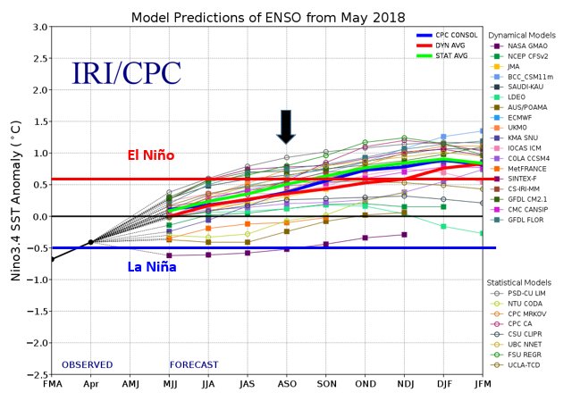
Nino incoming for next winter. Sub surface waters support this to. As Sroc stated in a tremendous write up above Modoki El Nino

amugs- Advanced Forecaster - Mod

- Posts : 15147
Join date : 2013-01-07
 Re: May 2018 Observations & Discussions
I'm starting to see some pretty stout resemblances to Harvey from last year with the development of our upcoming tropical cyclone in the Gulf. Not to the same strength, but the stagnation and duration; very similar evolution showing up here from what I can recall of last year and only at quick glances of modeling, but maybe somebody can confirm or dismiss this observation.
rb924119- Meteorologist

- Posts : 7091
Reputation : 195
Join date : 2013-02-06
Age : 32
Location : Greentown, Pa
 Re: May 2018 Observations & Discussions
AND HERE. WE. GOOOOOOOOOOOO!!!!


rb924119- Meteorologist

- Posts : 7091
Reputation : 195
Join date : 2013-02-06
Age : 32
Location : Greentown, Pa
 Re: May 2018 Observations & Discussions
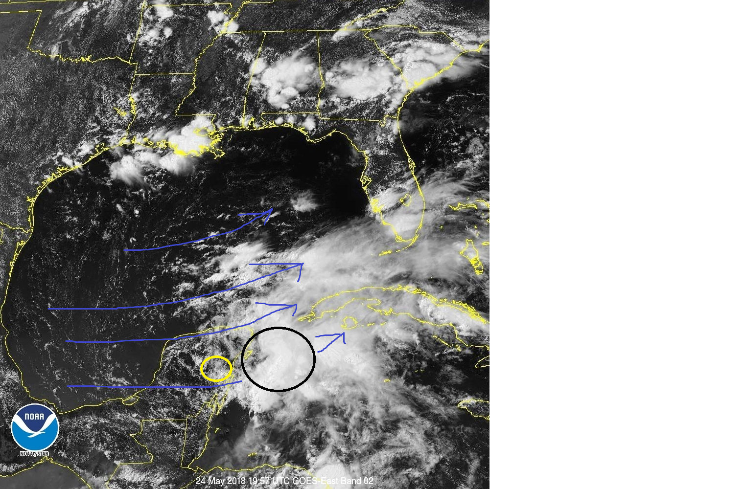
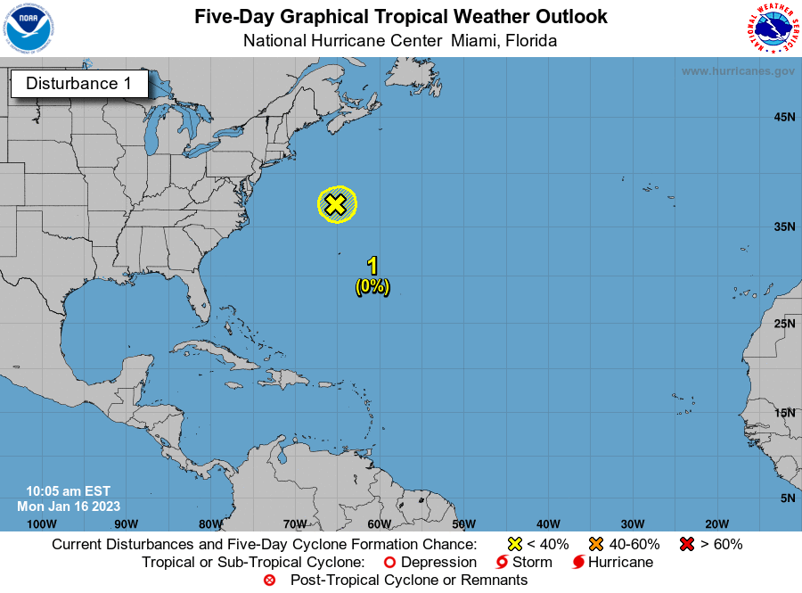
A distinct low level center of circulation can be seen over land now. (within the yellow circle). NHC has very high probability for trop development within the next 2-5days, however, only slow development is likely once the LLC moves out over open waters of the GOM over the next 2days. There is currently very strong wind shear(blue arrows) west to east to the north of the system that will likely inhibit any rapid intensification. Unless the shear drops off significantly anything beyond a TD or weak TS is not likely. Even that may not develop if the wind shear does not diminish some. Notice the higher cloud tops are well east of the LLC as a result of the shear(black circle).




_________________
"In weather and in life, there's no winning and losing; there's only winning and learning."
WINTER 2012/2013 TOTALS 43.65"WINTER 2017/2018 TOTALS 62.85" WINTER 2022/2023 TOTALS 4.9"
WINTER 2013/2014 TOTALS 64.85"WINTER 2018/2019 TOTALS 14.25" WINTER 2023/2024 TOTALS 13.1"
WINTER 2014/2015 TOTALS 71.20"WINTER 2019/2020 TOTALS 6.35" WINTER 2024/2025 TOTALS 0.00
WINTER 2015/2016 TOTALS 35.00"WINTER 2020/2021 TOTALS 37.75"
WINTER 2016/2017 TOTALS 42.25"WINTER 2021/2022 TOTALS 31.65"

sroc4- Admin

- Posts : 8458
Reputation : 302
Join date : 2013-01-07
Location : Wading River, LI
 Re: May 2018 Observations & Discussions
Another look at the current wind shear

_________________
"In weather and in life, there's no winning and losing; there's only winning and learning."
WINTER 2012/2013 TOTALS 43.65"WINTER 2017/2018 TOTALS 62.85" WINTER 2022/2023 TOTALS 4.9"
WINTER 2013/2014 TOTALS 64.85"WINTER 2018/2019 TOTALS 14.25" WINTER 2023/2024 TOTALS 13.1"
WINTER 2014/2015 TOTALS 71.20"WINTER 2019/2020 TOTALS 6.35" WINTER 2024/2025 TOTALS 0.00
WINTER 2015/2016 TOTALS 35.00"WINTER 2020/2021 TOTALS 37.75"
WINTER 2016/2017 TOTALS 42.25"WINTER 2021/2022 TOTALS 31.65"

sroc4- Admin

- Posts : 8458
Reputation : 302
Join date : 2013-01-07
Location : Wading River, LI
 Re: May 2018 Observations & Discussions

Hope this is wrong cause Beaches of NJ are going to be not good for Sun and Mon


_________________
Mugs
AKA:King: Snow Weenie
Self Proclaimed
WINTER 2014-15 : 55.12" +.02 for 6 coatings (avg. 35")
WINTER 2015-16 Total - 29.8" (Avg 35")
WINTER 2016-17 : 39.5" so far

amugs- Advanced Forecaster - Mod

- Posts : 15147
Reputation : 213
Join date : 2013-01-07
Age : 54
Location : Hillsdale,NJ
 Re: May 2018 Observations & Discussions

_________________
Mugs
AKA:King: Snow Weenie
Self Proclaimed
WINTER 2014-15 : 55.12" +.02 for 6 coatings (avg. 35")
WINTER 2015-16 Total - 29.8" (Avg 35")
WINTER 2016-17 : 39.5" so far

amugs- Advanced Forecaster - Mod

- Posts : 15147
Reputation : 213
Join date : 2013-01-07
Age : 54
Location : Hillsdale,NJ
 Re: May 2018 Observations & Discussions
sroc4 wrote:Another look at the current wind shear
Give it time, Scott. It has to couple and slide beneath the upper-level low. Once it does that it will begin to intensify pretty steadily I think. I think a high-end TS or low-end Cat-1 will be achievable here. Right now it is still out ahead of the mid-level feature which is why it's sheared right now - essentially it's developing like a typical mid-latitude cyclone (same processes involved right now). Once it gets beneath the mid- and upper-level low(s), the shear will back off significantly, and the low-level center can then begin the W.I.S.H.E. feedback and warm/intensify it from the bottom up.
rb924119- Meteorologist

- Posts : 7091
Reputation : 195
Join date : 2013-02-06
Age : 32
Location : Greentown, Pa
 Re: May 2018 Observations & Discussions
rb924119 wrote:sroc4 wrote:Another look at the current wind shear
Give it time, Scott. It has to couple and slide beneath the upper-level low. Once it does that it will begin to intensify pretty steadily I think. I think a high-end TS or low-end Cat-1 will be achievable here. Right now it is still out ahead of the mid-level feature which is why it's sheared right now - essentially it's developing like a typical mid-latitude cyclone (same processes involved right now). Once it gets beneath the mid- and upper-level low(s), the shear will back off significantly, and the low-level center can then begin the W.I.S.H.E. feedback and warm/intensify it from the bottom up.
Trust me I understand what your saying. The LLC is still over land; however, looking at the shear forecasts to the systems N over the next 48-72 hrs combined with the dry air that remains to the west of the system, I am highly skeptical that we ever achieve high end TS/Cat one status. If we do its very short lived and likely never becomes much of an issue for land with the exception of a very small area around the center as it is likely very short lived unless the center stalls just off the Gulf coast. There are some differences with the upper level trough over the GOM now between the GFS and Euro regarding its orientation over the next 72hrs. If it remains neutral; certainly positive like it is now, then shear will prevent any real good organization and coupling of the mid/upper level centers with the LLC; however if it tilts neg then maybe. Well see just how organized this system can really get, but for now I am skeptical. I think IF we see true tropical characteristics and organization beyond a weak TS/Depression status we need to wait until it reaches at least 25-26N lat to do so. Well see.
_________________
"In weather and in life, there's no winning and losing; there's only winning and learning."
WINTER 2012/2013 TOTALS 43.65"WINTER 2017/2018 TOTALS 62.85" WINTER 2022/2023 TOTALS 4.9"
WINTER 2013/2014 TOTALS 64.85"WINTER 2018/2019 TOTALS 14.25" WINTER 2023/2024 TOTALS 13.1"
WINTER 2014/2015 TOTALS 71.20"WINTER 2019/2020 TOTALS 6.35" WINTER 2024/2025 TOTALS 0.00
WINTER 2015/2016 TOTALS 35.00"WINTER 2020/2021 TOTALS 37.75"
WINTER 2016/2017 TOTALS 42.25"WINTER 2021/2022 TOTALS 31.65"

sroc4- Admin

- Posts : 8458
Reputation : 302
Join date : 2013-01-07
Location : Wading River, LI
 Re: May 2018 Observations & Discussions
Looks like several LLC this morning on visible sat imagery


_________________
"In weather and in life, there's no winning and losing; there's only winning and learning."
WINTER 2012/2013 TOTALS 43.65"WINTER 2017/2018 TOTALS 62.85" WINTER 2022/2023 TOTALS 4.9"
WINTER 2013/2014 TOTALS 64.85"WINTER 2018/2019 TOTALS 14.25" WINTER 2023/2024 TOTALS 13.1"
WINTER 2014/2015 TOTALS 71.20"WINTER 2019/2020 TOTALS 6.35" WINTER 2024/2025 TOTALS 0.00
WINTER 2015/2016 TOTALS 35.00"WINTER 2020/2021 TOTALS 37.75"
WINTER 2016/2017 TOTALS 42.25"WINTER 2021/2022 TOTALS 31.65"

sroc4- Admin

- Posts : 8458
Reputation : 302
Join date : 2013-01-07
Location : Wading River, LI
 Re: May 2018 Observations & Discussions
sroc4 wrote:Looks like several LLC this morning on visible sat imagery
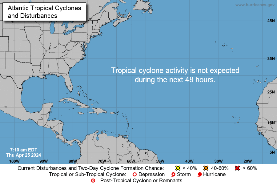
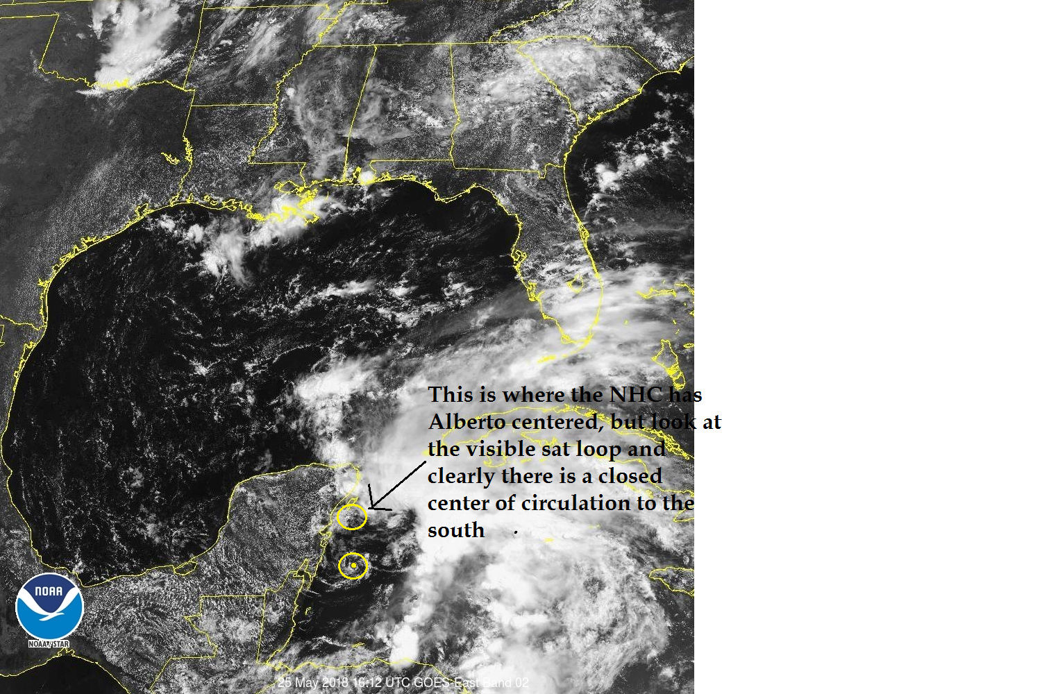
They named it this morning. We have "Sub Tropical Storm" Alberto.
_________________
"In weather and in life, there's no winning and losing; there's only winning and learning."
WINTER 2012/2013 TOTALS 43.65"WINTER 2017/2018 TOTALS 62.85" WINTER 2022/2023 TOTALS 4.9"
WINTER 2013/2014 TOTALS 64.85"WINTER 2018/2019 TOTALS 14.25" WINTER 2023/2024 TOTALS 13.1"
WINTER 2014/2015 TOTALS 71.20"WINTER 2019/2020 TOTALS 6.35" WINTER 2024/2025 TOTALS 0.00
WINTER 2015/2016 TOTALS 35.00"WINTER 2020/2021 TOTALS 37.75"
WINTER 2016/2017 TOTALS 42.25"WINTER 2021/2022 TOTALS 31.65"

sroc4- Admin

- Posts : 8458
Reputation : 302
Join date : 2013-01-07
Location : Wading River, LI
 Re: May 2018 Observations & Discussions
Personally I think thats ridiculous and a bit premature, because clearly there is a LLC well south of where they have the center positioned meaning that there are at least two LLCs, and it is still highly disorganized.



_________________
"In weather and in life, there's no winning and losing; there's only winning and learning."
WINTER 2012/2013 TOTALS 43.65"WINTER 2017/2018 TOTALS 62.85" WINTER 2022/2023 TOTALS 4.9"
WINTER 2013/2014 TOTALS 64.85"WINTER 2018/2019 TOTALS 14.25" WINTER 2023/2024 TOTALS 13.1"
WINTER 2014/2015 TOTALS 71.20"WINTER 2019/2020 TOTALS 6.35" WINTER 2024/2025 TOTALS 0.00
WINTER 2015/2016 TOTALS 35.00"WINTER 2020/2021 TOTALS 37.75"
WINTER 2016/2017 TOTALS 42.25"WINTER 2021/2022 TOTALS 31.65"

sroc4- Admin

- Posts : 8458
Reputation : 302
Join date : 2013-01-07
Location : Wading River, LI
 Re: May 2018 Observations & Discussions
wow hit 90* ....i love the sun...but can I ask how many days till winter???? 

weatherwatchermom- Senior Enthusiast

- Posts : 3892
Reputation : 78
Join date : 2014-11-25
Location : Hazlet Township, NJ
 Re: May 2018 Observations & Discussions
sroc4 wrote:Personally I think thats ridiculous and a bit premature, because clearly there is a LLC well south of where they have the center positioned meaning that there are at least two LLCs, and it is still highly disorganized.
what happened to the like button? like

weatherwatchermom- Senior Enthusiast

- Posts : 3892
Reputation : 78
Join date : 2014-11-25
Location : Hazlet Township, NJ
 Re: May 2018 Observations & Discussions
88 degrees with sunny skies. Tomorrow I am heading out to the beach even though the water temperature is still cold but I am jumping in.
frank 638- Senior Enthusiast

- Posts : 2878
Reputation : 37
Join date : 2016-01-01
Age : 41
Location : bronx ny
 Re: May 2018 Observations & Discussions
weatherwatchermom wrote:sroc4 wrote:Personally I think thats ridiculous and a bit premature, because clearly there is a LLC well south of where they have the center positioned meaning that there are at least two LLCs, and it is still highly disorganized.
what happened to the like button? like
I dont know?? Frank must have done something to it because I didnt.
_________________
"In weather and in life, there's no winning and losing; there's only winning and learning."
WINTER 2012/2013 TOTALS 43.65"WINTER 2017/2018 TOTALS 62.85" WINTER 2022/2023 TOTALS 4.9"
WINTER 2013/2014 TOTALS 64.85"WINTER 2018/2019 TOTALS 14.25" WINTER 2023/2024 TOTALS 13.1"
WINTER 2014/2015 TOTALS 71.20"WINTER 2019/2020 TOTALS 6.35" WINTER 2024/2025 TOTALS 0.00
WINTER 2015/2016 TOTALS 35.00"WINTER 2020/2021 TOTALS 37.75"
WINTER 2016/2017 TOTALS 42.25"WINTER 2021/2022 TOTALS 31.65"

sroc4- Admin

- Posts : 8458
Reputation : 302
Join date : 2013-01-07
Location : Wading River, LI
 Re: May 2018 Observations & Discussions
Perfect day to be at the beach even though the water was cold. Now we have lots of lightning and thunder early high of 90 degrees
frank 638- Senior Enthusiast

- Posts : 2878
Reputation : 37
Join date : 2016-01-01
Age : 41
Location : bronx ny
 Re: May 2018 Observations & Discussions
Hi of 90.2° here, totally sucked being on call with all my gear on, 2 calls back to back, 2nd one we were outside. Was drinking so much water I thought I would float away!
_________________
Janet
Snowfall winter of 2023-2024 17.5"
Snowfall winter of 2022-2023 6.0"
Snowfall winter of 2021-2022 17.6" 1" sleet 2/25/22
Snowfall winter of 2020-2021 51.1"
Snowfall winter of 2019-2020 8.5"
Snowfall winter of 2018-2019 25.1"
Snowfall winter of 2017-2018 51.9"
Snowfall winter of 2016-2017 45.6"
Snowfall winter of 2015-2016 29.5"
Snowfall winter of 2014-2015 50.55"
Snowfall winter of 2013-2014 66.5"
Dunnzoo- Senior Enthusiast - Mod

- Posts : 4934
Reputation : 68
Join date : 2013-01-11
Age : 62
Location : Westwood, NJ
 Re: May 2018 Observations & Discussions
And today, 61° and cool breeze, still socked in with clouds. Thankfully had no plans today, so I guess I'll cook!
_________________
Janet
Snowfall winter of 2023-2024 17.5"
Snowfall winter of 2022-2023 6.0"
Snowfall winter of 2021-2022 17.6" 1" sleet 2/25/22
Snowfall winter of 2020-2021 51.1"
Snowfall winter of 2019-2020 8.5"
Snowfall winter of 2018-2019 25.1"
Snowfall winter of 2017-2018 51.9"
Snowfall winter of 2016-2017 45.6"
Snowfall winter of 2015-2016 29.5"
Snowfall winter of 2014-2015 50.55"
Snowfall winter of 2013-2014 66.5"

Dunnzoo- Senior Enthusiast - Mod

- Posts : 4934
Reputation : 68
Join date : 2013-01-11
Age : 62
Location : Westwood, NJ
 Re: May 2018 Observations & Discussions
Catastrophic flash flooding again in Ellicott City, MD and around Baltomore area in general.
https://www.washingtonpost.com/news/capital-weather-gang/wp/2018/05/27/flash-flood-emergency-in-ellicott-city-md-as-thunderstorms-unload-excessive-rainfall/?utm_term=.a08232039aff
https://www.washingtonpost.com/news/capital-weather-gang/wp/2018/05/27/flash-flood-emergency-in-ellicott-city-md-as-thunderstorms-unload-excessive-rainfall/?utm_term=.a08232039aff
It’s happening all over again. Main Street in @EllicottCity with devastating flooding. @CairnsKcairns @FOXBaltimore @wbaltv11 @wjz video courtesy my sister Kali Harris. (Explicit language) #EllicottCity #Maryland pic.twitter.com/IuwBRyPRzW
— Jeremy Harris (@JeremyHarrisTV) May 27, 2018
Dtone- Wx Statistician Guru

- Posts : 1738
Reputation : 9
Join date : 2013-08-26
Location : Bronx, NY
 Re: May 2018 Observations & Discussions
OMG dtone! That is unbelievable
_________________
"In weather and in life, there's no winning and losing; there's only winning and learning."
WINTER 2012/2013 TOTALS 43.65"WINTER 2017/2018 TOTALS 62.85" WINTER 2022/2023 TOTALS 4.9"
WINTER 2013/2014 TOTALS 64.85"WINTER 2018/2019 TOTALS 14.25" WINTER 2023/2024 TOTALS 13.1"
WINTER 2014/2015 TOTALS 71.20"WINTER 2019/2020 TOTALS 6.35" WINTER 2024/2025 TOTALS 0.00
WINTER 2015/2016 TOTALS 35.00"WINTER 2020/2021 TOTALS 37.75"
WINTER 2016/2017 TOTALS 42.25"WINTER 2021/2022 TOTALS 31.65"

sroc4- Admin

- Posts : 8458
Reputation : 302
Join date : 2013-01-07
Location : Wading River, LI
 Re: May 2018 Observations & Discussions
Dtone wrote:Catastrophic flash flooding again in Ellicott City, MD and around Baltomore area in general.
https://www.washingtonpost.com/news/capital-weather-gang/wp/2018/05/27/flash-flood-emergency-in-ellicott-city-md-as-thunderstorms-unload-excessive-rainfall/?utm_term=.a08232039affIt’s happening all over again. Main Street in @EllicottCity with devastating flooding. @CairnsKcairns @FOXBaltimore @wbaltv11 @wjz video courtesy my sister Kali Harris. (Explicit language) #EllicottCity #Maryland pic.twitter.com/IuwBRyPRzW
— Jeremy Harris (@JeremyHarrisTV) May 27, 2018
saw that yesterday absolutely horrifying..feel so bad..they just recovered from the last flash flood

weatherwatchermom- Senior Enthusiast

- Posts : 3892
Reputation : 78
Join date : 2014-11-25
Location : Hazlet Township, NJ
 Re: May 2018 Observations & Discussions
we had 2.5 inches of rain yesterday...

weatherwatchermom- Senior Enthusiast

- Posts : 3892
Reputation : 78
Join date : 2014-11-25
Location : Hazlet Township, NJ
 Re: May 2018 Observations & Discussions
Just a few more days of May left. Time is flyin'
June looks like it wants to get off to a below normal start. A lot of cut-off low's showing up in the long range under an NAO block.
Weather in general in our area has been uneventful for my liking. Looks like a rainy weekend ahead. Why have our weekends been timed with crap weather??
June looks like it wants to get off to a below normal start. A lot of cut-off low's showing up in the long range under an NAO block.
Weather in general in our area has been uneventful for my liking. Looks like a rainy weekend ahead. Why have our weekends been timed with crap weather??
_________________
_______________________________________________________________________________________________________
CLICK HERE to view NJ Strong Snowstorm Classifications
 Re: May 2018 Observations & Discussions
Frank_Wx wrote:Just a few more days of May left. Time is flyin'
June looks like it wants to get off to a below normal start. A lot of cut-off low's showing up in the long range under an NAO block.
Weather in general in our area has been uneventful for my liking. Looks like a rainy weekend ahead. Why have our weekends been timed with crap weather??
Happy belated Birthday you old timer!!!! Hahaha hope your day was well spent!! Your post is music to my ears regarding the extended; I'm done with this heat, give me winter again!!! Frank, you're the man to get that accomplished......I beg of you, please strike a deal with Mother Nature lol or as you also said, at least make it more interesting to pass the time lmao
rb924119- Meteorologist

- Posts : 7091
Reputation : 195
Join date : 2013-02-06
Age : 32
Location : Greentown, Pa
 Re: May 2018 Observations & Discussions
rb924119 wrote:Frank_Wx wrote:Just a few more days of May left. Time is flyin'
June looks like it wants to get off to a below normal start. A lot of cut-off low's showing up in the long range under an NAO block.
Weather in general in our area has been uneventful for my liking. Looks like a rainy weekend ahead. Why have our weekends been timed with crap weather??
Happy belated Birthday you old timer!!!! Hahaha hope your day was well spent!! Your post is music to my ears regarding the extended; I'm done with this heat, give me winter again!!! Frank, you're the man to get that accomplished......I beg of you, please strike a deal with Mother Nature lol or as you also said, at least make it more interesting to pass the time lmao
Already miss the cold, eh?
Here is the cut-off low this weekend:
 '
'Then next week the trough offshore links with another dropping down from Canada:

And mid-June the trough is still there

Obviously below normal in June is not "cold" but it will not be the scorching heat nor humid air mass we've seen. The west is going to BAKE.
_________________
_______________________________________________________________________________________________________
CLICK HERE to view NJ Strong Snowstorm Classifications
Page 6 of 7 •  1, 2, 3, 4, 5, 6, 7
Permissions in this forum:
You cannot reply to topics in this forum
 Home
Home