Long Range Discussion 20(20) (Ha!)
+43
toople
TheAresian
Koroptim
Bkdude
essexcountypete
chief7
GreyBeard
crippo84
hyde345
lglickman1
Zhukov1945
bloc1357
SENJsnowman
Snow88
CPcantmeasuresnow
bobjohnsonforthehall
weatherwatchermom
skinsfan1177
billg315
SoulSingMG
phil155
aiannone
nutleyblizzard
Math23x7
Wheezer
Irish
Frank_Wx
mwilli
Grselig
Isotherm
heehaw453
jimv45
frank 638
docstox12
rb924119
sroc4
HectorO
algae888
dkodgis
Radz
jmanley32
amugs
Dunnzoo
47 posters
Page 17 of 30
Page 17 of 30 •  1 ... 10 ... 16, 17, 18 ... 23 ... 30
heehaw453- Advanced Forecaster

- Posts : 3931
Join date : 2014-01-20
 Re: Long Range Discussion 20(20) (Ha!)
In terms of chances before 1/10 guidance is clearly colder now for 1/5-1/8 than the torch it was showing a few days ago. You take the +10 days out with a grain of salt.
heehaw453- Advanced Forecaster

- Posts : 3931
Join date : 2014-01-20
 Re: Long Range Discussion 20(20) (Ha!)
Def a thread the needle type event, but we've seen it happen before. All we can do is track it and hope for the best.
_________________
"In weather and in life, there's no winning and losing; there's only winning and learning."
WINTER 2012/2013 TOTALS 43.65"WINTER 2017/2018 TOTALS 62.85" WINTER 2022/2023 TOTALS 4.9"
WINTER 2013/2014 TOTALS 64.85"WINTER 2018/2019 TOTALS 14.25" WINTER 2023/2024 TOTALS 13.1"
WINTER 2014/2015 TOTALS 71.20"WINTER 2019/2020 TOTALS 6.35" WINTER 2024/2025 TOTALS 0.00
WINTER 2015/2016 TOTALS 35.00"WINTER 2020/2021 TOTALS 37.75"
WINTER 2016/2017 TOTALS 42.25"WINTER 2021/2022 TOTALS 31.65"

sroc4- Admin

- Posts : 8458
Reputation : 302
Join date : 2013-01-07
Location : Wading River, LI
heehaw453- Advanced Forecaster

- Posts : 3931
Reputation : 86
Join date : 2014-01-20
Location : Bedminster Township, PA Elevation 600' ASL
 Re: Long Range Discussion 20(20) (Ha!)
heehaw453 wrote:In terms of chances before 1/10 guidance is clearly colder now for 1/5-1/8 than the torch it was showing a few days ago. You take the +10 days out with a grain of salt.
We’re headed toward a very active cold and snowy pattern in my opinion. I understand Rays concern with the Pac, but I think it’s going to improve JUST enough to promote eastern US cold/snow chances.
Also, I will look to start a new thread for the event on the 3rd sometime tomorrow. But if anyone gets to it today, be my guest!!
_________________
_______________________________________________________________________________________________________
CLICK HERE to view NJ Strong Snowstorm Classifications
sroc4, heehaw453 and phil155 like this post
 Re: Long Range Discussion 20(20) (Ha!)
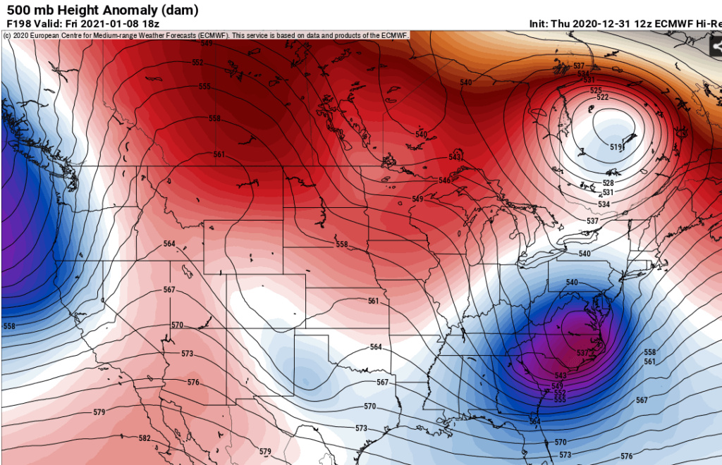
It looks like models are finally starting to catch on to the blocking Heights have lowered significantly for our region as a piece of the polar vortex breaks off and sits in Ontario and Quebec and that's not in Fantasyland right around day 7 looks like our good pattern is being pushed up in time the new Euro weeklies just came out and it's an epic pattern right through the end of January a once in every 10-year pattern get ready folks here we go

algae888- Advanced Forecaster

- Posts : 5311
Reputation : 46
Join date : 2013-02-05
Age : 62
Location : mt. vernon, new york
 Re: Long Range Discussion 20(20) (Ha!)
18z Nam came in colder for the Sunday system and now has accumulating snow for the city north and west.

algae888- Advanced Forecaster

- Posts : 5311
Reputation : 46
Join date : 2013-02-05
Age : 62
Location : mt. vernon, new york
 Re: Long Range Discussion 20(20) (Ha!)
algae888 wrote:It looks like models are finally starting to catch on to the blocking Heights have lowered significantly for our region as a piece of the polar vortex breaks off and sits in Ontario and Quebec and that's not in Fantasyland right around day 7 looks like our good pattern is being pushed up in time the new Euro weeklies just came out and it's an epic pattern right through the end of January a once in every 10-year pattern get ready folks here we go
Al you have bought a ticket for tjis Winter Train?
Who else is ready to get on board?
Look at this map and sorry but you'll be stuck in a frozen hell if not. The block is moving up as Al stated and you get a 50/50 from these storms and log jam up the hotlantic and...look at this map EPS. 2009-10, 10-11 , 77-78 look here peeps.

_________________
Mugs
AKA:King: Snow Weenie
Self Proclaimed
WINTER 2014-15 : 55.12" +.02 for 6 coatings (avg. 35")
WINTER 2015-16 Total - 29.8" (Avg 35")
WINTER 2016-17 : 39.5" so far

amugs- Advanced Forecaster - Mod

- Posts : 15148
Reputation : 213
Join date : 2013-01-07
Age : 54
Location : Hillsdale,NJ
 Re: Long Range Discussion 20(20) (Ha!)
I am ready but cautiously optimistic as sroc says. Hoping we might see something down here Sunday but it may just be too warm, we will see.

jmanley32- Senior Enthusiast

- Posts : 20645
Reputation : 108
Join date : 2013-12-12
Age : 43
Location : Yonkers, NY
 Re: Long Range Discussion 20(20) (Ha!)
I havent heard you say this in quite sometime, maybe a year or two, lets hope you are right. I much prefer snow over rain.Frank_Wx wrote:heehaw453 wrote:In terms of chances before 1/10 guidance is clearly colder now for 1/5-1/8 than the torch it was showing a few days ago. You take the +10 days out with a grain of salt.
We’re headed toward a very active cold and snowy pattern in my opinion. I understand Rays concern with the Pac, but I think it’s going to improve JUST enough to promote eastern US cold/snow chances.
Also, I will look to start a new thread for the event on the 3rd sometime tomorrow. But if anyone gets to it today, be my guest!!

jmanley32- Senior Enthusiast

- Posts : 20645
Reputation : 108
Join date : 2013-12-12
Age : 43
Location : Yonkers, NY
 Re: Long Range Discussion 20(20) (Ha!)
Here he comes PEEPS MR PV Doing a BANANA SPLIT!
Off Tweeter
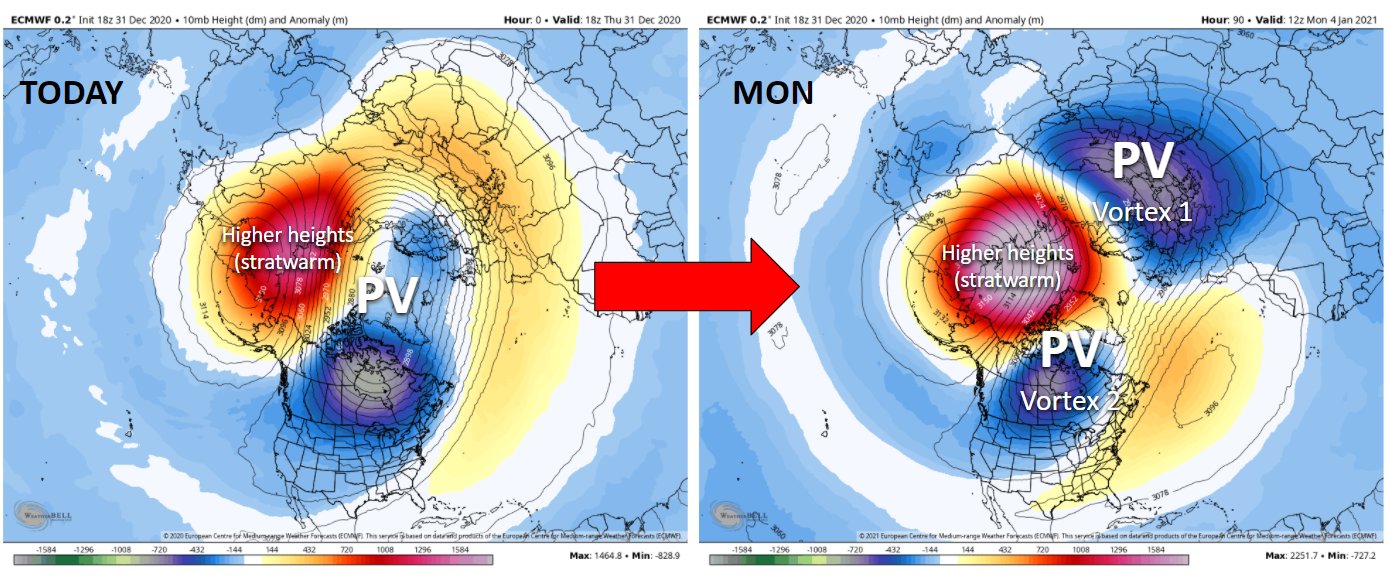
From DEC 23rd and right on cue
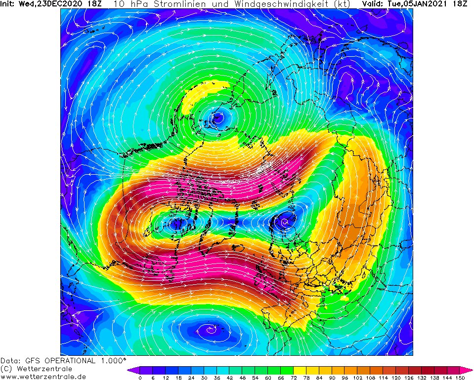
Off Tweeter

From DEC 23rd and right on cue

_________________
Mugs
AKA:King: Snow Weenie
Self Proclaimed
WINTER 2014-15 : 55.12" +.02 for 6 coatings (avg. 35")
WINTER 2015-16 Total - 29.8" (Avg 35")
WINTER 2016-17 : 39.5" so far

amugs- Advanced Forecaster - Mod

- Posts : 15148
Reputation : 213
Join date : 2013-01-07
Age : 54
Location : Hillsdale,NJ
 Re: Long Range Discussion 20(20) (Ha!)
just looked the gfs model long range. check out 1/15 rain off coast/snow ny/nnj looks big right now happy new year
mwilli- Posts : 132
Reputation : 3
Join date : 2019-02-11
 Re: Long Range Discussion 20(20) (Ha!)
If there is a Mothrazilla Sunday, remember that almost three years ago to the day we had another come to town
https://www.njstrongweatherforum.com/t876-january-4th-mothrazilla-final-call-observations?highlight=Mothrazilla
https://www.njstrongweatherforum.com/t876-january-4th-mothrazilla-final-call-observations?highlight=Mothrazilla

dkodgis- Senior Enthusiast

- Posts : 2688
Reputation : 98
Join date : 2013-12-29
 Re: Long Range Discussion 20(20) (Ha!)
dkodgis wrote:If there is a Mothrazilla Sunday, remember that almost three years ago to the day we had another come to town
https://www.njstrongweatherforum.com/t876-january-4th-mothrazilla-final-call-observations?highlight=Mothrazilla
That storm was a brilliant high end Godzilla for the Jersey Shore.
SENJsnowman- Senior Enthusiast

- Posts : 1198
Reputation : 61
Join date : 2017-01-06
Age : 51
Location : Long Branch, NJ
 Re: Long Range Discussion 20(20) (Ha!)
amugs wrote:Here he comes PEEPS MR PV Doing a BANANA SPLIT!
Off Tweeter
From DEC 23rd and right on cue
If the Strat PV splits, which is still a big IF in my opinion, we are going to love mid-Jan into most of February. Regardless, the Wave 1 warming / displacement of the PV will give us a nice 10-day stretch of winter weather beginning around January 8th.
_________________
_______________________________________________________________________________________________________
CLICK HERE to view NJ Strong Snowstorm Classifications
 Re: Long Range Discussion 20(20) (Ha!)
I am thinking this will in part present itself in lower temps. The reason I say this is I see temps still at upper 30s and low 20s up here in the look aheads

dkodgis- Senior Enthusiast

- Posts : 2688
Reputation : 98
Join date : 2013-12-29
 Re: Long Range Discussion 20(20) (Ha!)
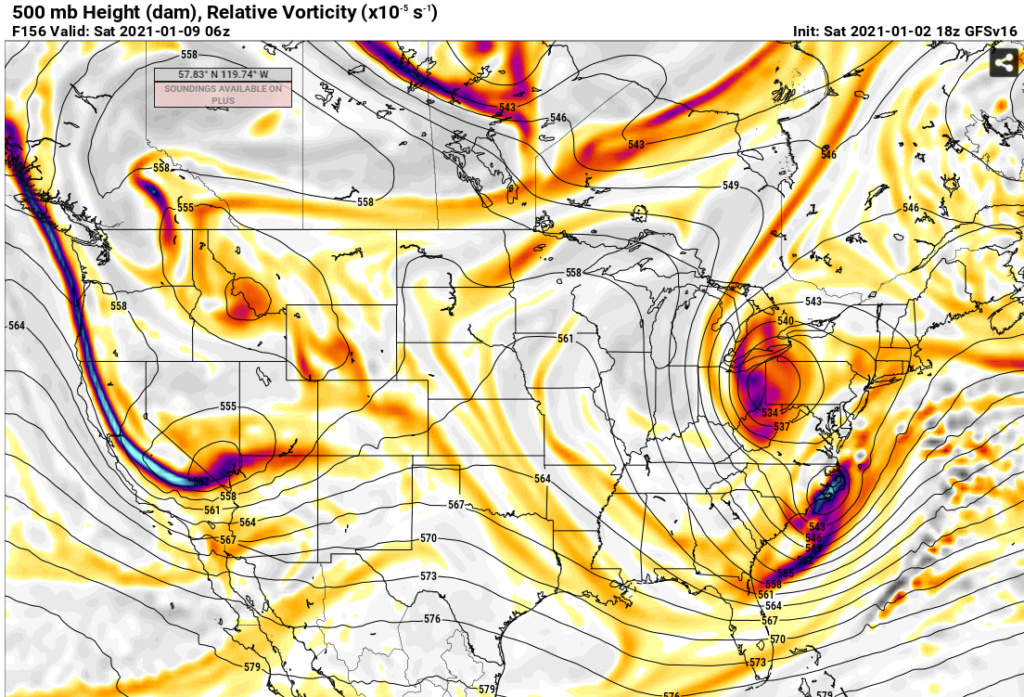
A couple things I noticed from the long range GFS regarding next week (1/9), and I wondered if someone can weigh in and tell me if I'm interpreting things correctly.
The GFS has always been showing some kind of system coming off the Carolinas, but now seems to more consistently a storm with cold air involved, as evidenced by the snow developing in southern and western Virginia and northern North Carolina.
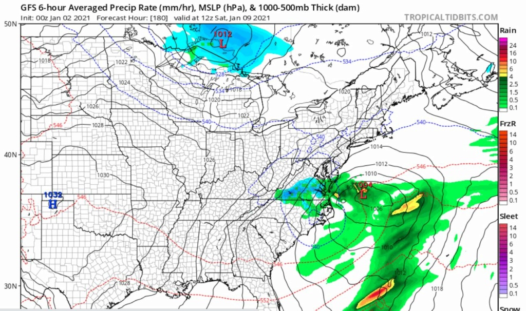
In fact, the latest run shows a stronger low forming producing some heavy snow into those areas.


And the lower levels appear to be cold.


And it also looks like a trough forms and TRIES to swing negative, and in fact does, but just a little too late.

Still a swing and a miss, if I'm even seeing this correct, but it looks like things are trying to happen.
The GFS has always been showing some kind of system coming off the Carolinas, but now seems to more consistently a storm with cold air involved, as evidenced by the snow developing in southern and western Virginia and northern North Carolina.

In fact, the latest run shows a stronger low forming producing some heavy snow into those areas.


And the lower levels appear to be cold.


And it also looks like a trough forms and TRIES to swing negative, and in fact does, but just a little too late.

Still a swing and a miss, if I'm even seeing this correct, but it looks like things are trying to happen.
SENJsnowman- Senior Enthusiast

- Posts : 1198
Reputation : 61
Join date : 2017-01-06
Age : 51
Location : Long Branch, NJ
 Re: Long Range Discussion 20(20) (Ha!)
SENJsnowman wrote:A couple things I noticed from the long range GFS regarding next week (1/9), and I wondered if someone can weigh in and tell me if I'm interpreting things correctly.
The GFS has always been showing some kind of system coming off the Carolinas, but now seems to more consistently a storm with cold air involved, as evidenced by the snow developing in southern and western Virginia and northern North Carolina.
In fact, the latest run shows a stronger low forming producing some heavy snow into those areas.
And the lower levels appear to be cold.
And it also looks like a trough forms and TRIES to swing negative, and in fact does, but just a little too late.
Still a swing and a miss, if I'm even seeing this correct, but it looks like things are trying to happen.
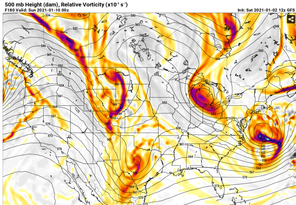
For sure there have been signals amongst the guidance for that time frame. The 500mb trough needs to go negative as it hits the coast to guide the system up the coast, otherwise it's going to be pushed right out to sea. The other unknown is how much cold air will be available for this when/if we get to that point.
So the two things we don't really know are: 1) Will this trough stay neutral and this storm pushes out to sea. 2) will the southern stream interact with northern stream to supply more cold air and make it a powerful storm that gets guided up the coast.
At this time it's just a window of interest. In a blocking situation where the atmosphere is not progressive the models aren't going to be much help with better clues until probably day 5. I'll say this take the under on the temps for whatever models are showing 7 days from now in -NAO/-AO pattern.
heehaw453- Advanced Forecaster

- Posts : 3931
Reputation : 86
Join date : 2014-01-20
Location : Bedminster Township, PA Elevation 600' ASL
 Re: Long Range Discussion 20(20) (Ha!)
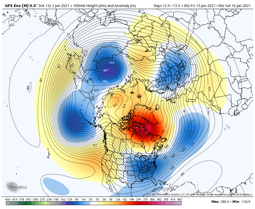
Heehaw I concur - with this GEFS look its going to be a very int3rsting and fun tracking time.
Looks like we have storms:
3-4h
Other upcoming time frames
8th
12th
15/16th
Looks like we have storms:
3-4h
Other upcoming time frames
8th
12th
15/16th

_________________
Mugs
AKA:King: Snow Weenie
Self Proclaimed
WINTER 2014-15 : 55.12" +.02 for 6 coatings (avg. 35")
WINTER 2015-16 Total - 29.8" (Avg 35")
WINTER 2016-17 : 39.5" so far

amugs- Advanced Forecaster - Mod

- Posts : 15148
Reputation : 213
Join date : 2013-01-07
Age : 54
Location : Hillsdale,NJ
 Re: Long Range Discussion 20(20) (Ha!)
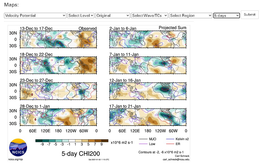
MJO forcing set to move into 7-8-1-2 as per AM tweet - here is the chart

_________________
Mugs
AKA:King: Snow Weenie
Self Proclaimed
WINTER 2014-15 : 55.12" +.02 for 6 coatings (avg. 35")
WINTER 2015-16 Total - 29.8" (Avg 35")
WINTER 2016-17 : 39.5" so far

amugs- Advanced Forecaster - Mod

- Posts : 15148
Reputation : 213
Join date : 2013-01-07
Age : 54
Location : Hillsdale,NJ
 Re: Long Range Discussion 20(20) (Ha!)
amugs wrote:MJO forcing set to move into 7-8-1-2 as per AM tweet - here is the chart
What are the best numbers for positive setups?

Irish- Pro Enthusiast

- Posts : 788
Reputation : 19
Join date : 2019-01-16
Age : 46
Location : Old Bridge, NJ
 Re: Long Range Discussion 20(20) (Ha!)
amugs wrote:MJO forcing set to move into 7-8-1-2 as per AM tweet - here is the chart
It was supposed to do this three weeks ago and it never did. I don’t trust these forecasts, as I’m pretty sure they’re based on the CFS which has a known bias of being too progressive in the tropics. To date, the standing wave over the Maritime Continent has ruled the roost regarding these circulation forecasts and their expected impacts, and given the status of things, I don’t see that changing.
rb924119- Meteorologist

- Posts : 7097
Reputation : 195
Join date : 2013-02-06
Age : 32
Location : Greentown, Pa
 Re: Long Range Discussion 20(20) (Ha!)
The mjo is a non-factor this year as it's been basically in The Circle of Death since the first of December

algae888- Advanced Forecaster

- Posts : 5311
Reputation : 46
Join date : 2013-02-05
Age : 62
Location : mt. vernon, new york
heehaw453- Advanced Forecaster

- Posts : 3931
Reputation : 86
Join date : 2014-01-20
Location : Bedminster Township, PA Elevation 600' ASL
 Re: Long Range Discussion 20(20) (Ha!)
The 12z CMC was a big blow for eastern CT and the cape with godzilla there, super narrow miss here but southern jersey gets a mothrazilla. I will be happy for them if they get it as they rarely see a good storm. What do you guys think about the 12z CMC for 9th? Will it be a threat for the area for a good size storm? Asking cuz I am supposed be going somewhere they day and want to plan accordingly. Though I can drive in pretty much anything, it's others I am concerned about.

jmanley32- Senior Enthusiast

- Posts : 20645
Reputation : 108
Join date : 2013-12-12
Age : 43
Location : Yonkers, NY
 Re: Long Range Discussion 20(20) (Ha!)
It's going to probably get interesting in regard to tracking here in a hurry. Several models are starting to like the threat for 1/8 and i don't think that's the only one we'll be looking at either. We'll see if guidance continues to favor 1/8 and I think we'll know soon if this is legit or not.
heehaw453- Advanced Forecaster

- Posts : 3931
Reputation : 86
Join date : 2014-01-20
Location : Bedminster Township, PA Elevation 600' ASL
 Re: Long Range Discussion 20(20) (Ha!)
Every 4 days we have threats on the GFS seeing rhe block. Pro Mets Simon Lee, Alex Borehem and Petong saying this block could be liken to 2010 or greater. Time will tell.
JMAN to far out to tell, one storm at a time. Could be Monthra here as well.
Get your sleep folks its going to be a busy period. And who said no snow rhe next two weeks?? LOL.
4 years of lowest solar in recorded history, extremely small sample, showing some muscle here. Cosmic rays are high levels for years now as well.
Volcanoes erupting, percolating, EQ rumbling. Going to be wild folks. Be prepared and not scared.
_________________
Mugs
AKA:King: Snow Weenie
Self Proclaimed
WINTER 2014-15 : 55.12" +.02 for 6 coatings (avg. 35")
WINTER 2015-16 Total - 29.8" (Avg 35")
WINTER 2016-17 : 39.5" so far

amugs- Advanced Forecaster - Mod

- Posts : 15148
Reputation : 213
Join date : 2013-01-07
Age : 54
Location : Hillsdale,NJ
Page 17 of 30 •  1 ... 10 ... 16, 17, 18 ... 23 ... 30
Page 17 of 30
Permissions in this forum:
You cannot reply to topics in this forum
 Home
Home
