Long Range Discussion 20(20) (Ha!)
+43
toople
TheAresian
Koroptim
Bkdude
essexcountypete
chief7
GreyBeard
crippo84
hyde345
lglickman1
Zhukov1945
bloc1357
SENJsnowman
Snow88
CPcantmeasuresnow
bobjohnsonforthehall
weatherwatchermom
skinsfan1177
billg315
SoulSingMG
phil155
aiannone
nutleyblizzard
Math23x7
Wheezer
Irish
Frank_Wx
mwilli
Grselig
Isotherm
heehaw453
jimv45
frank 638
docstox12
rb924119
sroc4
HectorO
algae888
dkodgis
Radz
jmanley32
amugs
Dunnzoo
47 posters
Page 27 of 30
Page 27 of 30 •  1 ... 15 ... 26, 27, 28, 29, 30
 Re: Long Range Discussion 20(20) (Ha!)
Lol @ "I'm not falling for the banana in the tailpipe again." Great movie reference.
But yes, this 1/31 to 2/1 system does seem to have a more favorable set-up and is beginning to generate some chatter. We'll see how it plays out as the week progresses because I Won't Get Fooled Again.
But yes, this 1/31 to 2/1 system does seem to have a more favorable set-up and is beginning to generate some chatter. We'll see how it plays out as the week progresses because I Won't Get Fooled Again.
billg315- Advanced Forecaster - Mod

- Posts : 4562
Join date : 2015-01-24
 Re: Long Range Discussion 20(20) (Ha!)
billg315 wrote:Lol @ "I'm not falling for the banana in the tailpipe again." Great movie reference.
But yes, this 1/31 to 2/1 system does seem to have a more favorable set-up and is beginning to generate some chatter. We'll see how it plays out as the week progresses because I Won't Get Fooled Again.
But do you prefer the banana in the tailpipe?
Irish- Pro Enthusiast

- Posts : 788
Join date : 2019-01-16
 Re: Long Range Discussion 20(20) (Ha!)
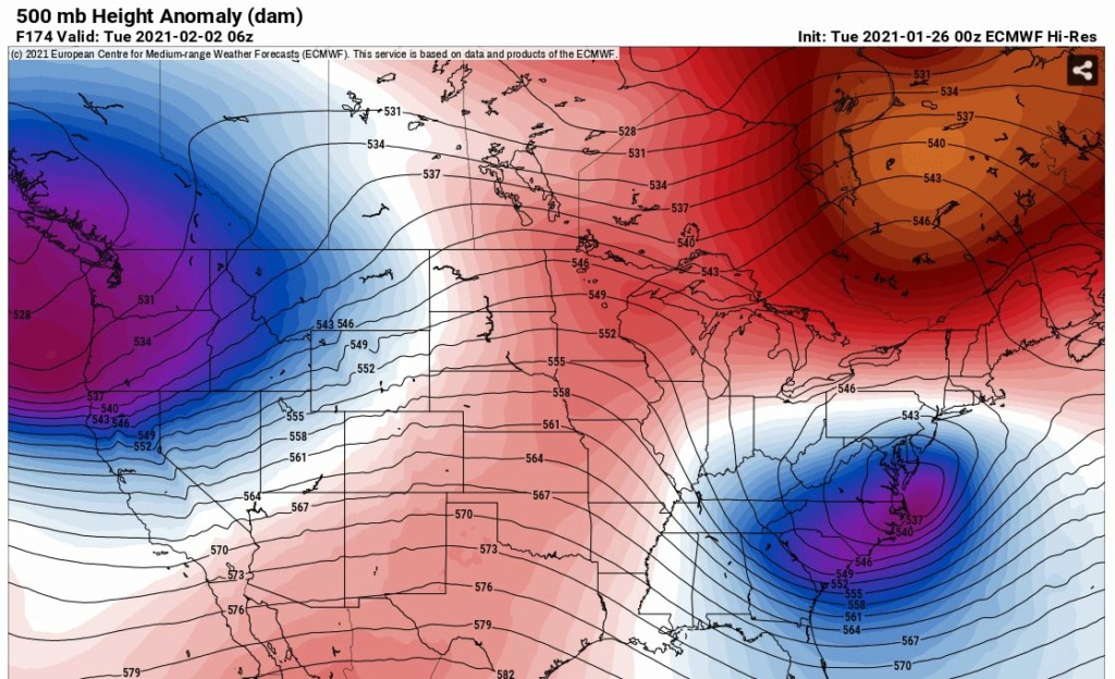
I want to believe in the 0Z Euro today w.r.t. 1/31. I really do. Closed off and stalled upper level low that just dumps snow on us for many an hour. Ahh sweet dreams.
heehaw453- Advanced Forecaster

- Posts : 3936
Reputation : 86
Join date : 2014-01-20
Location : Bedminster Township, PA Elevation 600' ASL
 Re: Long Range Discussion 20(20) (Ha!)
heehaw453 wrote:I want to believe in the 0Z Euro today w.r.t. 1/31. I really do. Closed off and stalled upper level low that just dumps snow on us for many an hour. Ahh sweet dreams.
Would be nice if it actually came to fruition. Actually if it hits 1/31 that would give us a major snowstorm in December and one in January. Get one more in February and frankly that’s an average winter in these parts.
But, too far out for now. As we’ve seen theses things can fizzle when they appear in the 5-6 day range. So I’m heading back to the pool of drunken pessimism for a couple days hoping it changes our luck. Lol.

billg315- Advanced Forecaster - Mod

- Posts : 4562
Reputation : 185
Join date : 2015-01-24
Age : 50
Location : Flemington, NJ
 Re: Long Range Discussion 20(20) (Ha!)
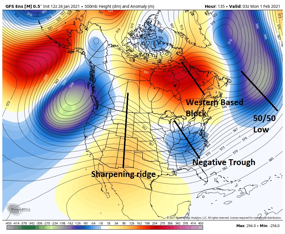
This definitely has more legs than the other 2 waves. Better ridge in better placement. I would not be expecting much in northerly trends with this if this Euro 500 mb is correct. That block is pretty far south to James Bay. If anything I could see this getting pushed further south. It's also why I'm hesitant on a big SCOPE storm because it's going to make it harder for heights to rise and allow for a negative tilt of the trough. In your big snow makers that cover wide areas troughs will tilt more negatively to throw moisture well inland. If the trough doesn't tilt negative then it's a much smaller scope of precipitation. Doesn't mean smaller areas can't get hit hard though. My thought on this now is moderate impact potential and watching for southerly trends.

heehaw453- Advanced Forecaster

- Posts : 3936
Reputation : 86
Join date : 2014-01-20
Location : Bedminster Township, PA Elevation 600' ASL
 Re: Long Range Discussion 20(20) (Ha!)
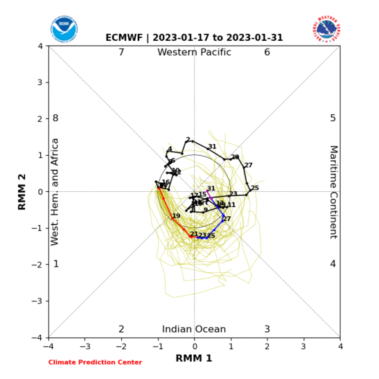
If we can get to PHSAE 8 for Feb later 1st week then usually about a 3-4 day lag time we get the pattern to be more favorable for cold and storminess. See if it happens

_________________
Mugs
AKA:King: Snow Weenie
Self Proclaimed
WINTER 2014-15 : 55.12" +.02 for 6 coatings (avg. 35")
WINTER 2015-16 Total - 29.8" (Avg 35")
WINTER 2016-17 : 39.5" so far

amugs- Advanced Forecaster - Mod

- Posts : 15149
Reputation : 213
Join date : 2013-01-07
Age : 54
Location : Hillsdale,NJ
 Re: Long Range Discussion 20(20) (Ha!)
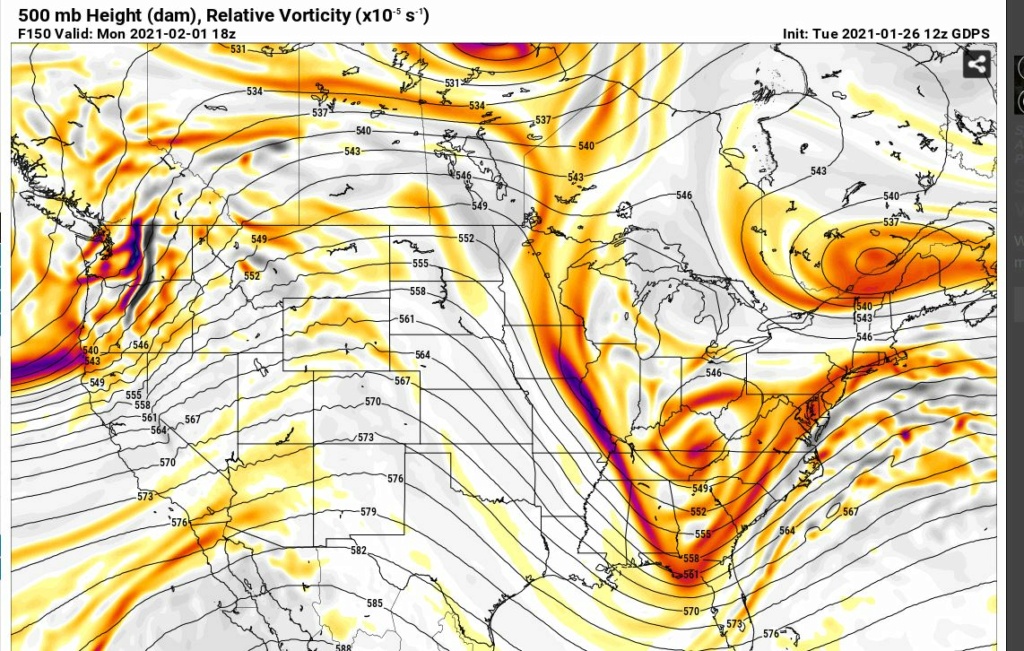
This 500 mb is kind of what I'm thinking from the CMC. You have a good setup. Deep trough due to good ridge in west and very vigorous shortwave. The only thing preventing this from blowing up to a major snowstorm is the upper energy doesn't meet up with the energy off the coast. The trough just needs a bit of a negative tilt and the surface panels would be very different. The press in NNE would cap how far north it gets. As is this would be a moderate to low end significant hit for most. That's why I'd keep my expectation to moderate as the interaction of the energy and the press of the northern block is no where near from being known. Going to see models go back and forth. I would be surprised to get nothing though.

heehaw453- Advanced Forecaster

- Posts : 3936
Reputation : 86
Join date : 2014-01-20
Location : Bedminster Township, PA Elevation 600' ASL

CPcantmeasuresnow- Wx Statistician Guru

- Posts : 7284
Reputation : 230
Join date : 2013-01-08
Age : 103
Location : Eastern Orange County, NY

jmanley32- Senior Enthusiast

- Posts : 20645
Reputation : 108
Join date : 2013-12-13
Age : 43
Location : Yonkers, NY
 Re: Long Range Discussion 20(20) (Ha!)
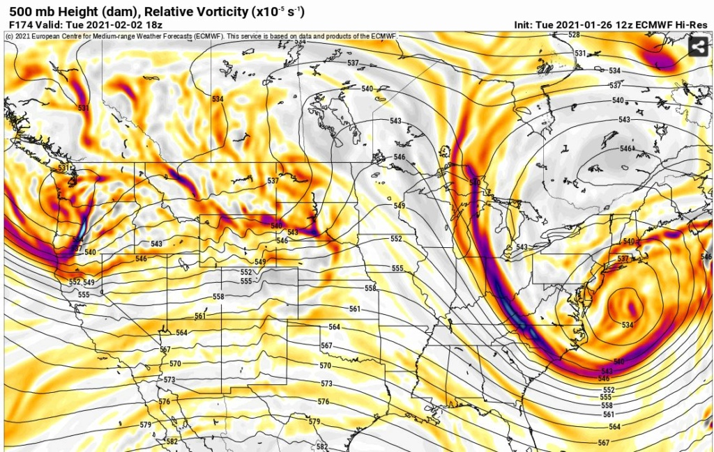
Dare I show excitement at this range. I like look on this one right now. The ULL closing off underneath us is very intriguing. The relaxation of the -NAO may really give this a shot to come up. Getting confident someone on the east coast is going to get really nailed with this. Will it be us? To me it depends on confluence and any potential press on the ULL from NE.

heehaw453- Advanced Forecaster

- Posts : 3936
Reputation : 86
Join date : 2014-01-20
Location : Bedminster Township, PA Elevation 600' ASL
weatherwatchermom likes this post
 Re: Long Range Discussion 20(20) (Ha!)
heehaw453 wrote:Dare I show excitement at this range. I like look on this one right now. The ULL closing off underneath us is very intriguing. The relaxation of the -NAO may really give this a shot to come up. Getting confident someone on the east coast is going to get really nailed with this. Will it be us? To me it depends on confluence and any potential press on the ULL from NE.
Ah the good ol' long range bait and switch.
I've never fully understood how to interpret that image. What displays that the ULL has closed off? How would you explain how that's demonstrated to the challenged folk like myself?
I always am interested when the experts on this forum pointing out when a low closes off and I understand that it loses connection with the main upper air flow. But does that image show this?
If this is a dumb question - I'm asking for a friend.

crippo84- Posts : 383
Reputation : 20
Join date : 2013-11-07
Age : 40
Location : East Village, NYC
Irish likes this post
 Re: Long Range Discussion 20(20) (Ha!)
crippo84 wrote:heehaw453 wrote:Dare I show excitement at this range. I like look on this one right now. The ULL closing off underneath us is very intriguing. The relaxation of the -NAO may really give this a shot to come up. Getting confident someone on the east coast is going to get really nailed with this. Will it be us? To me it depends on confluence and any potential press on the ULL from NE.
Ah the good ol' long range bait and switch.
I've never fully understood how to interpret that image. What displays that the ULL has closed off? How would you explain how that's demonstrated to the challenged folk like myself?
I always am interested when the experts on this forum pointing out when a low closes off and I understand that it loses connection with the main upper air flow. But does that image show this?
If this is a dumb question - I'm asking for a friend.
Just a shade under 6 yrs ago this very same question was answered. I archived it in the weather education thread. Definitely NOT a dumb question.
https://www.njstrongweatherforum.com/t518-a-general-discussion-about-h5-500mb-and-cutoff-lows
_________________
"In weather and in life, there's no winning and losing; there's only winning and learning."
WINTER 2012/2013 TOTALS 43.65"WINTER 2017/2018 TOTALS 62.85" WINTER 2022/2023 TOTALS 4.9"
WINTER 2013/2014 TOTALS 64.85"WINTER 2018/2019 TOTALS 14.25" WINTER 2023/2024 TOTALS 13.1"
WINTER 2014/2015 TOTALS 71.20"WINTER 2019/2020 TOTALS 6.35" WINTER 2024/2025 TOTALS 0.00
WINTER 2015/2016 TOTALS 35.00"WINTER 2020/2021 TOTALS 37.75"
WINTER 2016/2017 TOTALS 42.25"WINTER 2021/2022 TOTALS 31.65"

sroc4- Admin

- Posts : 8458
Reputation : 302
Join date : 2013-01-07
Location : Wading River, LI
 Re: Long Range Discussion 20(20) (Ha!)
The EPS are very encouraging. They are not a look of suppression whatsoever. It's a look of a strong coastal climbing up the east coast. Powerful signal IMO.
heehaw453- Advanced Forecaster

- Posts : 3936
Reputation : 86
Join date : 2014-01-20
Location : Bedminster Township, PA Elevation 600' ASL
 Re: Long Range Discussion 20(20) (Ha!)
sroc4 wrote:crippo84 wrote:heehaw453 wrote:Dare I show excitement at this range. I like look on this one right now. The ULL closing off underneath us is very intriguing. The relaxation of the -NAO may really give this a shot to come up. Getting confident someone on the east coast is going to get really nailed with this. Will it be us? To me it depends on confluence and any potential press on the ULL from NE.
Ah the good ol' long range bait and switch.
I've never fully understood how to interpret that image. What displays that the ULL has closed off? How would you explain how that's demonstrated to the challenged folk like myself?
I always am interested when the experts on this forum pointing out when a low closes off and I understand that it loses connection with the main upper air flow. But does that image show this?
If this is a dumb question - I'm asking for a friend.
Just a shade under 6 yrs ago this very same question was answered. I archived it in the weather education thread. Definitely NOT a dumb question.
https://www.njstrongweatherforum.com/t518-a-general-discussion-about-h5-500mb-and-cutoff-lows
This was great - thank you!

crippo84- Posts : 383
Reputation : 20
Join date : 2013-11-07
Age : 40
Location : East Village, NYC
sroc4 likes this post
 Re: Long Range Discussion 20(20) (Ha!)
TWC is showing 6-12 inches for Sunday- early Tuesday this far out. I'm getting a little excited here. The tracking and antipating are my favorite part.

Irish- Pro Enthusiast

- Posts : 788
Reputation : 19
Join date : 2019-01-16
Age : 46
Location : Old Bridge, NJ
 Re: Long Range Discussion 20(20) (Ha!)
Would be nice to get some more insight on this Sunday-Monday/Tuesday system from some of the experts we have on the board as this system seems to have more potential that we have seen in a while
phil155- Pro Enthusiast

- Posts : 497
Reputation : 4
Join date : 2019-12-16
 Re: Long Range Discussion 20(20) (Ha!)
crippo84 wrote:sroc4 wrote:crippo84 wrote:heehaw453 wrote:Dare I show excitement at this range. I like look on this one right now. The ULL closing off underneath us is very intriguing. The relaxation of the -NAO may really give this a shot to come up. Getting confident someone on the east coast is going to get really nailed with this. Will it be us? To me it depends on confluence and any potential press on the ULL from NE.
Ah the good ol' long range bait and switch.
I've never fully understood how to interpret that image. What displays that the ULL has closed off? How would you explain how that's demonstrated to the challenged folk like myself?
I always am interested when the experts on this forum pointing out when a low closes off and I understand that it loses connection with the main upper air flow. But does that image show this?
If this is a dumb question - I'm asking for a friend.
Just a shade under 6 yrs ago this very same question was answered. I archived it in the weather education thread. Definitely NOT a dumb question.
https://www.njstrongweatherforum.com/t518-a-general-discussion-about-h5-500mb-and-cutoff-lows
This was great - thank you!
Great question, and thank you both for asking and answering. Love this place.

essexcountypete- Pro Enthusiast

- Posts : 783
Reputation : 12
Join date : 2013-12-09
Location : Bloomfield, NJ
 Re: Long Range Discussion 20(20) (Ha!)
Very cold air for the weekend. Could get down into the single digits Saturday and Sunday AM for some here and the low teens for others. Highs Saturday and Sunday may stay below freezing most places. I’m not going to get into the storm potential until we’re three days out. That’s my new rule I think. But cold air will not be in short supply.

billg315- Advanced Forecaster - Mod

- Posts : 4562
Reputation : 185
Join date : 2015-01-24
Age : 50
Location : Flemington, NJ
 Re: Long Range Discussion 20(20) (Ha!)
phil155 wrote:Would be nice to get some more insight on this Sunday-Monday/Tuesday system from some of the experts we have on the board as this system seems to have more potential that we have seen in a while
Well, since you asked...
The MJO is flip flopping around the stratospheric anomalies, while the -NAO, EPO and Greenland block intermingles with digging troughs over the James Bay, as Sir Mix-a-lot does the Humpty Dance into a bombo-genesis up the Atlantic Coast exploding dandruff all over us all!

Irish- Pro Enthusiast

- Posts : 788
Reputation : 19
Join date : 2019-01-16
Age : 46
Location : Old Bridge, NJ
heehaw453- Advanced Forecaster

- Posts : 3936
Reputation : 86
Join date : 2014-01-20
Location : Bedminster Township, PA Elevation 600' ASL
 Re: Long Range Discussion 20(20) (Ha!)
_________________
Mugs
AKA:King: Snow Weenie
Self Proclaimed
WINTER 2014-15 : 55.12" +.02 for 6 coatings (avg. 35")
WINTER 2015-16 Total - 29.8" (Avg 35")
WINTER 2016-17 : 39.5" so far

amugs- Advanced Forecaster - Mod

- Posts : 15149
Reputation : 213
Join date : 2013-01-07
Age : 54
Location : Hillsdale,NJ
 Re: Long Range Discussion 20(20) (Ha!)
All these ingredients IF they come together spell a good east coast snowstorm. Not even looking at snow or op maps at this stage. Long ways to go in the weather world.
NAO relaxing and AO drops a beast of cold from Friday afternoon through Sunday night here that helps set this up. Archambault Event? Some have been prolific storms in the past. Time will tell.
NAO relaxing and AO drops a beast of cold from Friday afternoon through Sunday night here that helps set this up. Archambault Event? Some have been prolific storms in the past. Time will tell.
_________________
Mugs
AKA:King: Snow Weenie
Self Proclaimed
WINTER 2014-15 : 55.12" +.02 for 6 coatings (avg. 35")
WINTER 2015-16 Total - 29.8" (Avg 35")
WINTER 2016-17 : 39.5" so far

amugs- Advanced Forecaster - Mod

- Posts : 15149
Reputation : 213
Join date : 2013-01-07
Age : 54
Location : Hillsdale,NJ
 Re: Long Range Discussion 20(20) (Ha!)
phil155 wrote:Would be nice to get some more insight on this Sunday-Monday/Tuesday system from some of the experts we have on the board as this system seems to have more potential that we have seen in a while
The key to the increased potential relative to the Thursday threat is "WAVE SPACING" here is the last portion of the write up I had for the now non threat to the Thursday system.

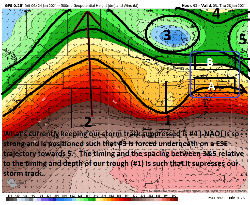
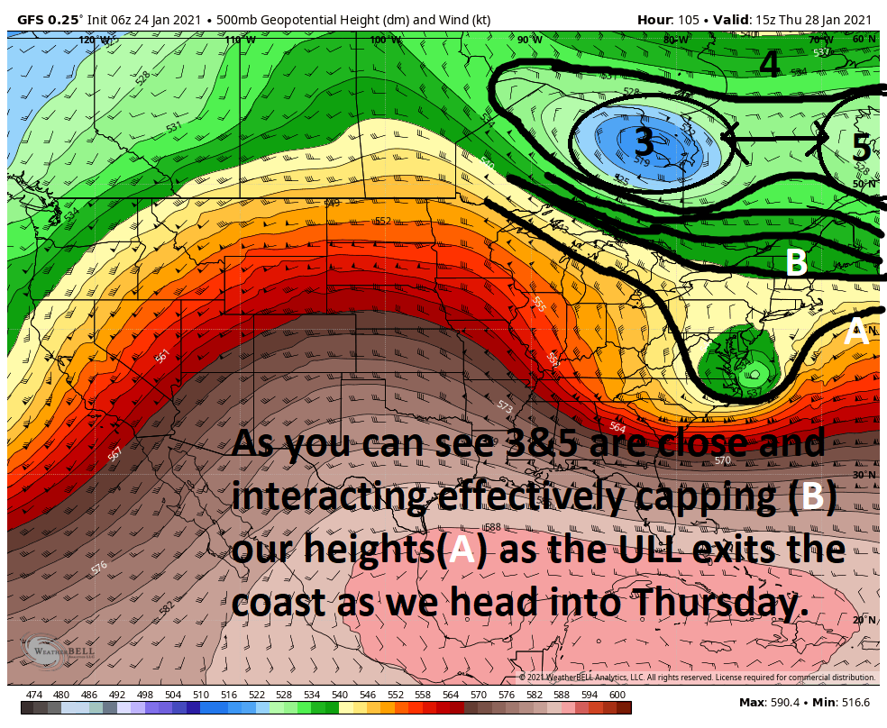

So Unfort IMHO the pattern is such that a more suppressed storm track is the most likely scenario, but areas as far north as the I95 along the CT coast should def keep on alert for any subtle shifts and from Atlantic city on southward are def in the game.
Here are a few scenarios either on their own or in combination that could allow for a more NEward shift to the storm track:
1) amplify 2 and 1 will dig more. If you dig the energy in 1 further south you amplify the trough. Picture two people holding opposite ends of a rubber band. You take your finger and push down in the middle of the rubber band. The more you push down in the middle the steeper the sides become.
2) if we can space out the distance between 3&5 a little ie: shift 5 east, then you have room for B to up effectively raising the ceiling to how high A can amplify as it reaches the coast.
3) If we can position 3 a tad further NW, W, or SW again we can increase the space between 3&5 effectively leaving room for our ceiling/Cap to increase allowing A to go up etc.
Again Ill reiterate or beat the dead horse; the pattern seems to me to suggest that a more suppressed track effectively taking most of our coverage area out of the main equation but thre are enough southern areas definitely in play here AND there is still plenty of lead time to see our models continue to evolve the situation....for better (up the coast) OR worse (even more suppressed.
As you can see above Ive bolded the things that needed to happen to give this system a chance, but unfort that does not appear to be happening for the Thursday system, BUT this next one things look better spread out. In the thursday threat The -NAO block is too strong and it defelects the TPV on that ESE trajectory. This combined with the fact that it is actually slightly out in front of the system causing it to deflect our Thursday system well south and E
Here is the zoomed out view of the Wed time frame with the system on approach for thursday. Once again highlighting everything. The white arrows indicate what the current modeling depicts the trough ridge configuration to the Sunday time frame, ie: the approach to the Monday system.
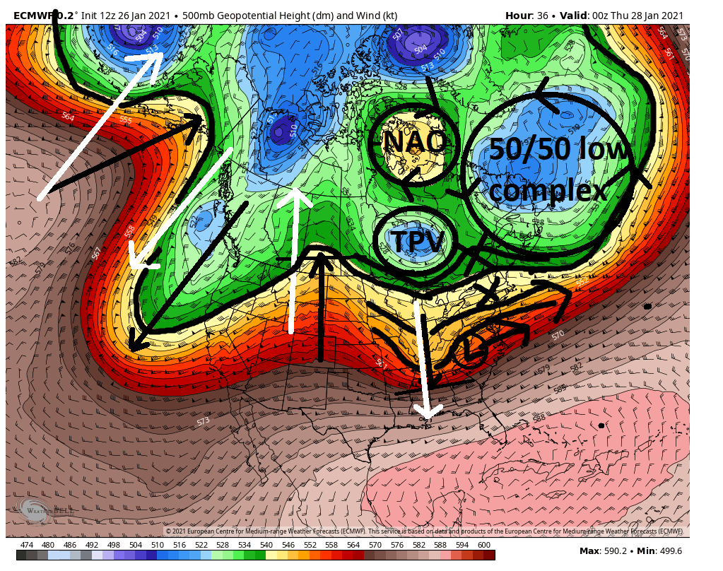
Now look at the approach to the Monday system. In this image the white arrows was the prev set up for comparison. Notice the amplitude of the ridge to the west is greater. The ridge out west is better because the long wave troughs and ridges behind IT are spread out better and in a better configuration for the room needed for it to be more amplified. The resultis a more amplified trough asscosited with our system as seen by how much further south the base of it is. Toggle between both images below and above to see what I mean.
Now look at the at the area where the -NAO and TPV were. Thius area is VERY diff and also vital for the set up. Without a strong -NAO we dont have the TPV diving ESE out ahead of our system steering it off the coast. Instead we actually have a short wave (as depicted by the circle and black arrrow right over N central CONUS. This is actaully energy that instead of steering our system actually gets added into the back side of the trough that is our system as it approaches the coast, aka phases with. If you read the ULL link I posted above to answer the ULL question you can see how this helps close off the upper levels into an ULL.
Because the ridge is a bit taller to the west, and because there is energy digging into the back side of the trough instead of out ahead steering the trough heights are able to amplyfy on the east side of the trough(yellow arrow). And because there is better spacing between the 505/low complex(5) and the energy digging into the back side of the trough(3) there area between (blue circle)
has room to get out of the way allowing the potential for our storm to come further north up the coast.
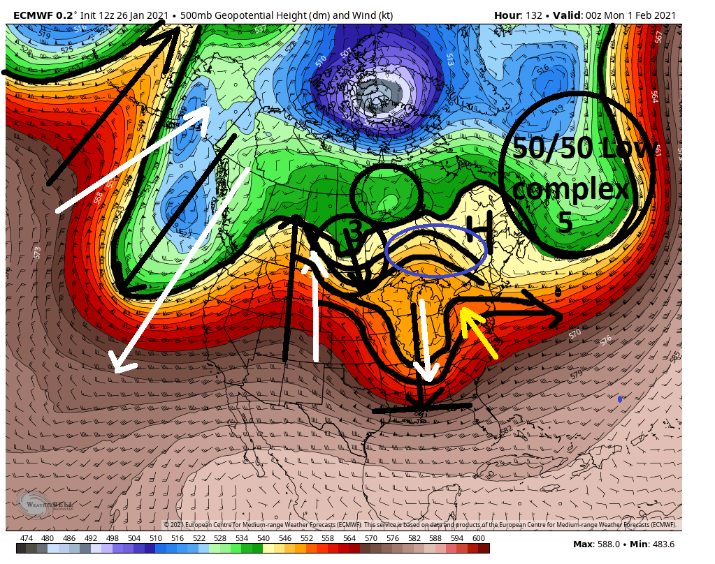
I really hope its not too confusing. To reiterate the key to this still boils down to timing and "WAVE SPACING" We shall see how the next few days plays out.
_________________
"In weather and in life, there's no winning and losing; there's only winning and learning."
WINTER 2012/2013 TOTALS 43.65"WINTER 2017/2018 TOTALS 62.85" WINTER 2022/2023 TOTALS 4.9"
WINTER 2013/2014 TOTALS 64.85"WINTER 2018/2019 TOTALS 14.25" WINTER 2023/2024 TOTALS 13.1"
WINTER 2014/2015 TOTALS 71.20"WINTER 2019/2020 TOTALS 6.35" WINTER 2024/2025 TOTALS 0.00
WINTER 2015/2016 TOTALS 35.00"WINTER 2020/2021 TOTALS 37.75"
WINTER 2016/2017 TOTALS 42.25"WINTER 2021/2022 TOTALS 31.65"

sroc4- Admin

- Posts : 8458
Reputation : 302
Join date : 2013-01-07
Location : Wading River, LI
 Re: Long Range Discussion 20(20) (Ha!)
_________________
Mugs
AKA:King: Snow Weenie
Self Proclaimed
WINTER 2014-15 : 55.12" +.02 for 6 coatings (avg. 35")
WINTER 2015-16 Total - 29.8" (Avg 35")
WINTER 2016-17 : 39.5" so far

amugs- Advanced Forecaster - Mod

- Posts : 15149
Reputation : 213
Join date : 2013-01-07
Age : 54
Location : Hillsdale,NJ
 Re: Long Range Discussion 20(20) (Ha!)
_________________
"In weather and in life, there's no winning and losing; there's only winning and learning."
WINTER 2012/2013 TOTALS 43.65"WINTER 2017/2018 TOTALS 62.85" WINTER 2022/2023 TOTALS 4.9"
WINTER 2013/2014 TOTALS 64.85"WINTER 2018/2019 TOTALS 14.25" WINTER 2023/2024 TOTALS 13.1"
WINTER 2014/2015 TOTALS 71.20"WINTER 2019/2020 TOTALS 6.35" WINTER 2024/2025 TOTALS 0.00
WINTER 2015/2016 TOTALS 35.00"WINTER 2020/2021 TOTALS 37.75"
WINTER 2016/2017 TOTALS 42.25"WINTER 2021/2022 TOTALS 31.65"

sroc4- Admin

- Posts : 8458
Reputation : 302
Join date : 2013-01-07
Location : Wading River, LI
 Re: Long Range Discussion 20(20) (Ha!)
SROC LOL!!!! 
_________________
Mugs
AKA:King: Snow Weenie
Self Proclaimed
WINTER 2014-15 : 55.12" +.02 for 6 coatings (avg. 35")
WINTER 2015-16 Total - 29.8" (Avg 35")
WINTER 2016-17 : 39.5" so far

amugs- Advanced Forecaster - Mod

- Posts : 15149
Reputation : 213
Join date : 2013-01-07
Age : 54
Location : Hillsdale,NJ
 Re: Long Range Discussion 20(20) (Ha!)
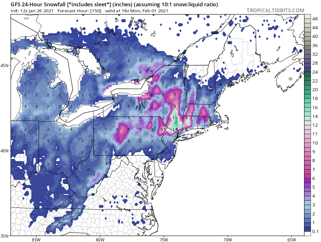
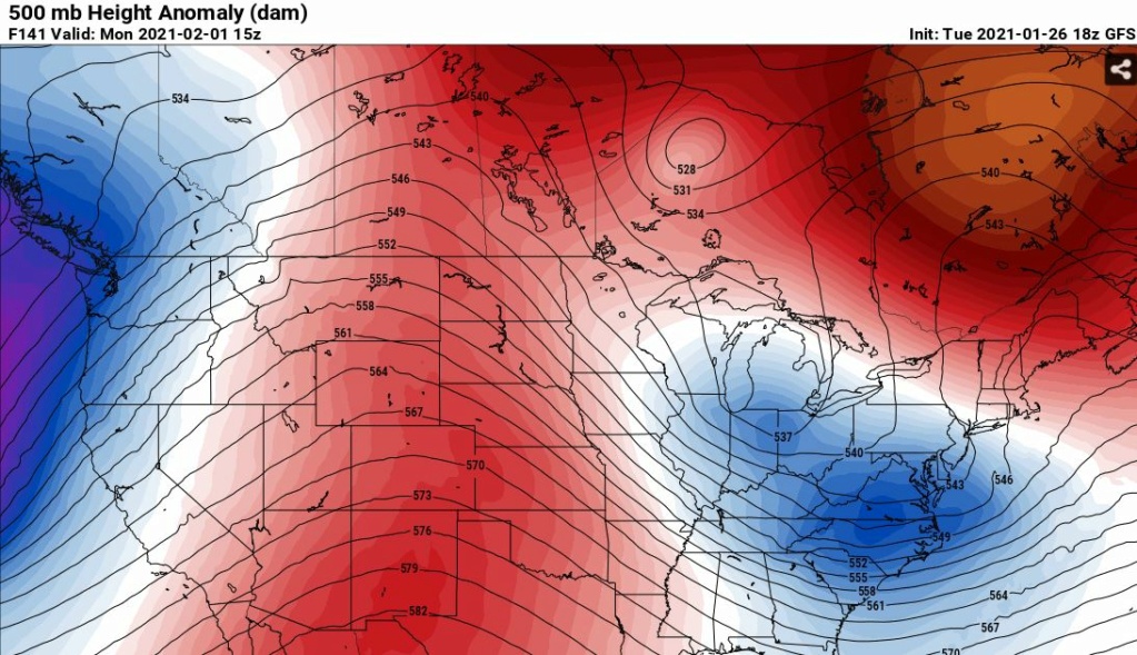
Look at the tilt of the trough on this latest GFS. That kind of tilt is basically throwing a bucket of water over the land mass after it's been filled up in the Atlantic. Big storm as shown and GFS is coming around to that. And no I'm not paying one bit of attention to GFS thermal profiles right now. I'm just trying to see what it's doing at the 500 mb.
What you are seeing is uncanny model agreement on a major EC storm at D5+. Details obviously are not known...
18Z GFS
What you are seeing is uncanny model agreement on a major EC storm at D5+. Details obviously are not known...
18Z GFS

heehaw453- Advanced Forecaster

- Posts : 3936
Reputation : 86
Join date : 2014-01-20
Location : Bedminster Township, PA Elevation 600' ASL
Page 27 of 30 •  1 ... 15 ... 26, 27, 28, 29, 30
Page 27 of 30
Permissions in this forum:
You cannot reply to topics in this forum
 Home
Home