Long Range Discussions 21.0
+33
jimv45
oldtimer
hyde345
sabamfa
SENJsnowman
essexcountypete
SNOW MAN
algae888
docstox12
mmanisca
skinsfan1177
rb924119
mwilli
weatherwatchermom
CPcantmeasuresnow
dkodgis
TheAresian
Snow88
Zhukov1945
Mike1984
dsix85
sroc4
lglickman1
WeatherBob
heehaw453
Irish
phil155
billg315
jmanley32
aiannone
frank 638
amugs
Frank_Wx
37 posters
Page 8 of 15
Page 8 of 15 •  1 ... 5 ... 7, 8, 9 ... 11 ... 15
 Re: Long Range Discussions 21.0
---
Last edited by phil155 on Thu Feb 11, 2021 8:04 pm; edited 1 time in total
phil155- Pro Enthusiast

- Posts : 497
Join date : 2019-12-16
 Re: Long Range Discussions 21.0
Nice push of cold to beat back that SE ridge a bit - every little bit helps and keep us colder and the mid levels to boot


amugs- Advanced Forecaster - Mod

- Posts : 15148
Join date : 2013-01-07
 Re: Long Range Discussions 21.0
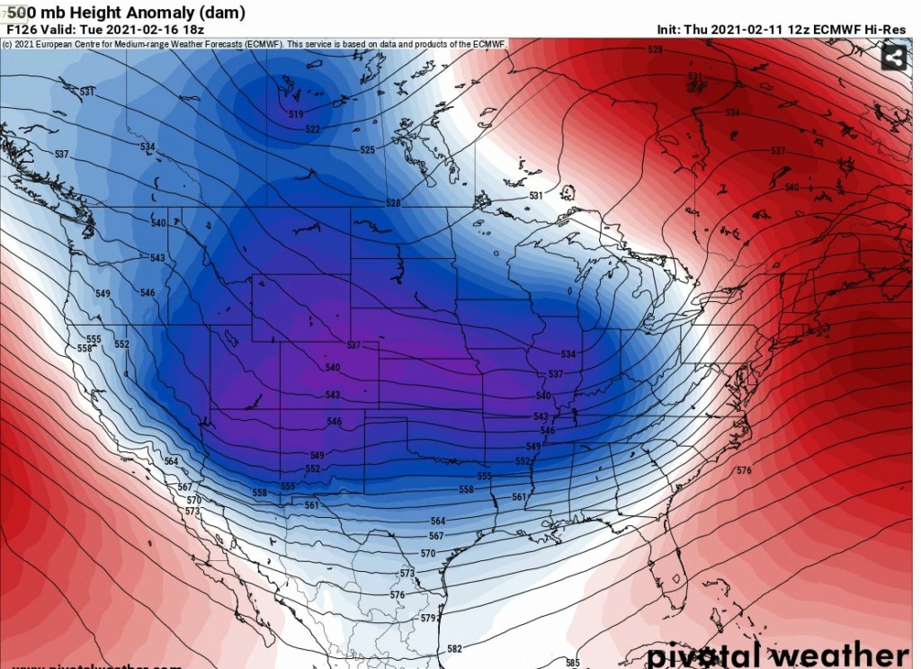
I dont know in the end how this all plays out just yet for the Tuesday system, but its been my experience in the past as we head later in the season when we have had high lat blocking in place like in strong persistent -EPO years, or in this year's case a strong -NAO/-AO couplet, you get a deep entrenched cold pool that has engulfed not just the local area but a very large portion of the area to our N and West. Its not uncommon to see models over due the SE ridge in the LT and MT.
When you get the strong energy coming out of the SW models like to over do the latent heat release resulting in a much stronger looking SE ridge in the modeling in the LR and Md range.
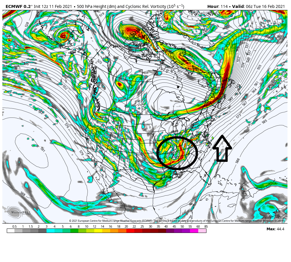
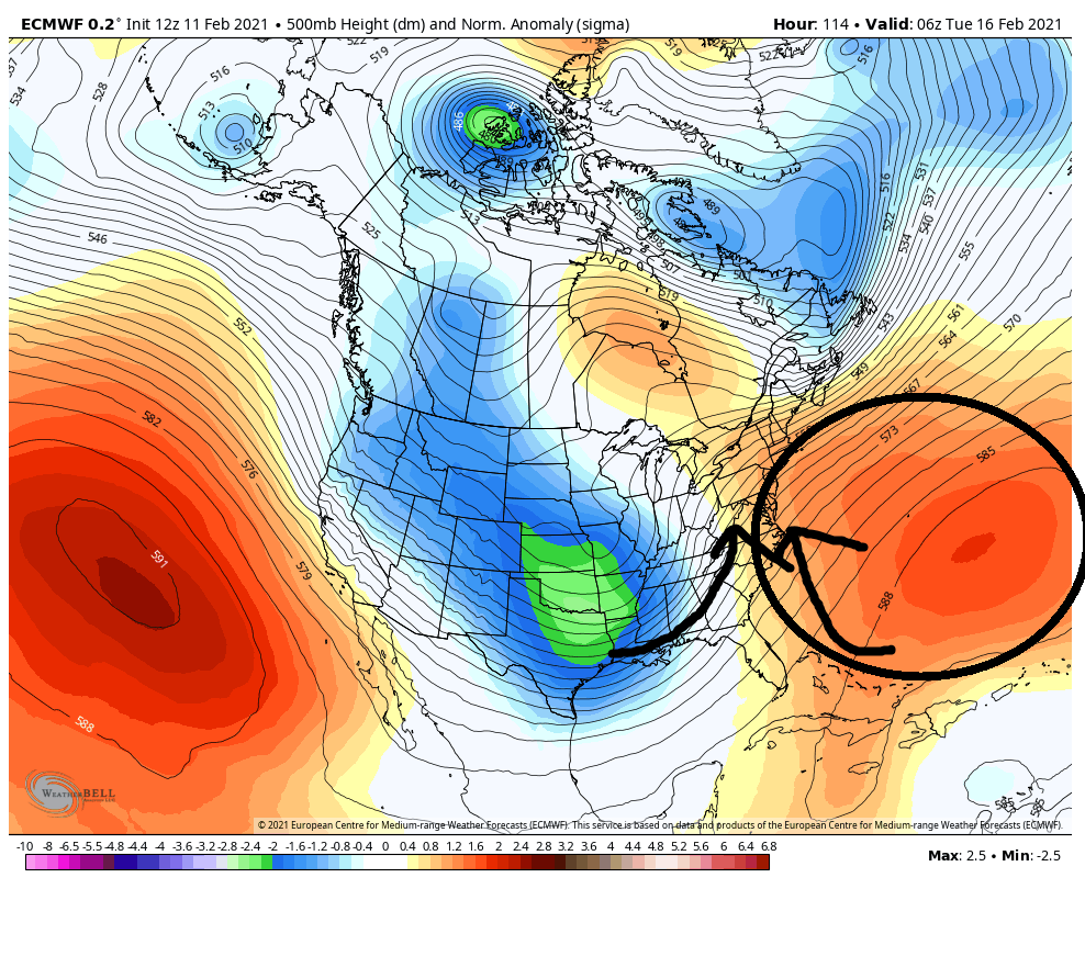
But as we begin to get in close the models begin to pick up on this firmly entrenched cold pool and realize its not going to be that easy to kick out. I mean we aren't talking about some marginally cold temps. We are talking about wide spread below 0*f temps on our front door, and single digits to teens already in our back yards having drinks. The pretty decent cold pack region wide enhances the denseness of this cold air.
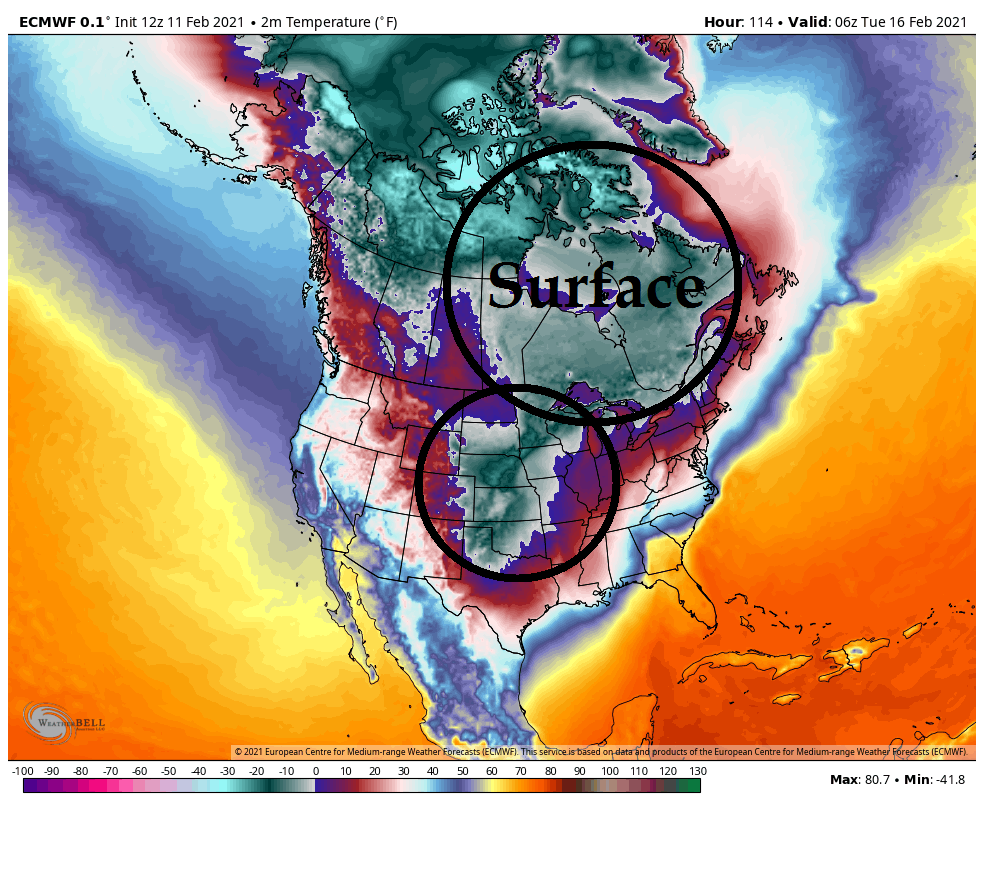
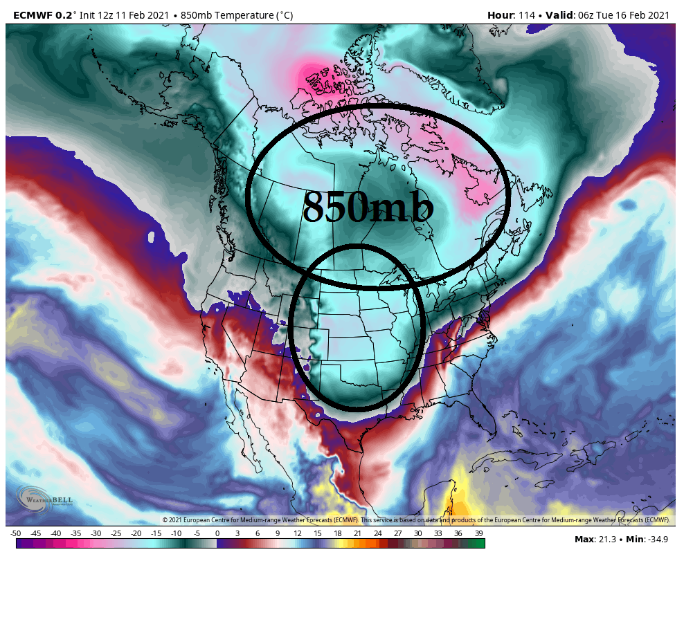
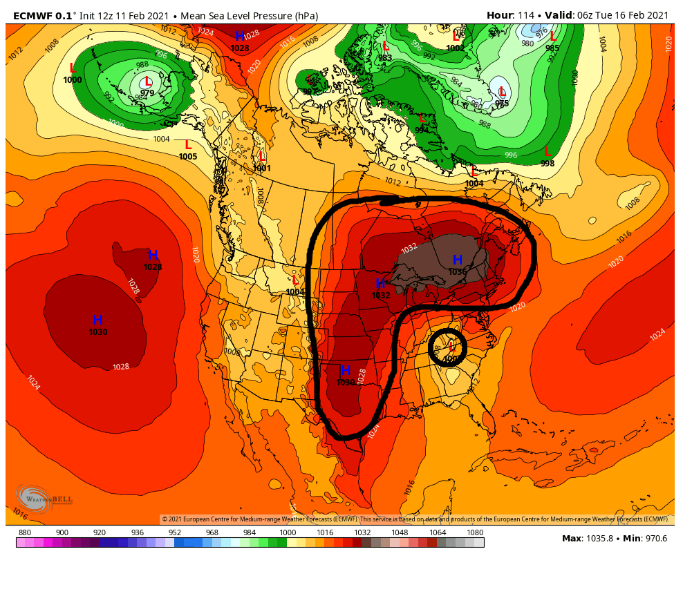
So when we get a banana HP set up like this with our low trying to plow through the Tenn valley into the Ohio valley I do not believe a cutter nor a coastal hugger ends up as our end product. Id be shocked if we didnt see a significant trend colder for the entire coverage area as we head into Sunday for the Tuesday system. A weaker primary transfering earlier and a LP track just inside to perhaps on the benchmark is my guess ATT simply based on the above stated experiences but again I dont know how it will end in the end. The coast of course will still need to worry about mixing issue(esp if inside the BM), and since it appears to be a pretty classic Miller B set up, an area of subsidence during the transfer is likely to screw someone. Should be interesting to see how this theory plays out over the next 3-4days. IMHO Tuesday has serious blockbuster potential.
WE TRACK!!

_________________
"In weather and in life, there's no winning and losing; there's only winning and learning."
WINTER 2012/2013 TOTALS 43.65"WINTER 2017/2018 TOTALS 62.85" WINTER 2022/2023 TOTALS 4.9"
WINTER 2013/2014 TOTALS 64.85"WINTER 2018/2019 TOTALS 14.25" WINTER 2023/2024 TOTALS 13.1"
WINTER 2014/2015 TOTALS 71.20"WINTER 2019/2020 TOTALS 6.35" WINTER 2024/2025 TOTALS 0.00
WINTER 2015/2016 TOTALS 35.00"WINTER 2020/2021 TOTALS 37.75"
WINTER 2016/2017 TOTALS 42.25"WINTER 2021/2022 TOTALS 31.65"

sroc4- Admin

- Posts : 8458
Reputation : 302
Join date : 2013-01-07
Location : Wading River, LI
amugs, rb924119, dolphins222 and phil155 like this post
 Re: Long Range Discussions 21.0
Like part two of 31st &1st potential?sroc4 wrote:
I dont know in the end how this all plays out just yet for the Tuesday system, but its been my experience in the past as we head later in the season when we have had high lat blocking in place like in strong persistent -EPO years, or in this year's case a strong -NAO/-AO couplet, you get a deep entrenched cold pool that has engulfed not just the local area but a very large portion of the area to our N and West. Its not uncommon to see models over due the SE ridge in the LT and MT.
When you get the strong energy coming out of the SW models like to over do the latent heat release resulting in a much stronger looking SE ridge in the modeling in the LR and Md range.
But as we begin to get in close the models begin to pick up on this firmly entrenched cold pool and realize its not going to be that easy to kick out. I mean we aren't talking about some marginally cold temps. We are talking about wide spread below 0*f temps on our front door, and single digits to teens already in our back yards having drinks. The pretty decent cold pack region wide enhances the denseness of this cold air.
So when we get a banana HP set up like this with our low trying to plow through the Tenn valley into the Ohio valley I do not believe a cutter nor a coastal hugger ends up as our end product. Id be shocked if we didnt see a significant trend colder for the entire coverage area as we head into Sunday for the Tuesday system. A weaker primary transfering earlier and a LP track just inside to perhaps on the benchmark is my guess ATT simply based on the above stated experiences but again I dont know how it will end in the end. The coast of course will still need to worry about mixing issue(esp if inside the BM), and since it appears to be a pretty classic Miller B set up, an area of subsidence during the transfer is likely to screw someone. Should be interesting to see how this theory plays out over the next 3-4days. IMHO Tuesday has serious blockbuster potential.
WE TRACK!!

jmanley32- Senior Enthusiast

- Posts : 20645
Reputation : 108
Join date : 2013-12-12
Age : 43
Location : Yonkers, NY
 Re: Long Range Discussions 21.0
sroc4 wrote:
I dont know in the end how this all plays out just yet for the Tuesday system, but its been my experience in the past as we head later in the season when we have had high lat blocking in place like in strong persistent -EPO years, or in this year's case a strong -NAO/-AO couplet, you get a deep entrenched cold pool that has engulfed not just the local area but a very large portion of the area to our N and West. Its not uncommon to see models over due the SE ridge in the LT and MT.
When you get the strong energy coming out of the SW models like to over do the latent heat release resulting in a much stronger looking SE ridge in the modeling in the LR and Md range.
But as we begin to get in close the models begin to pick up on this firmly entrenched cold pool and realize its not going to be that easy to kick out. I mean we aren't talking about some marginally cold temps. We are talking about wide spread below 0*f temps on our front door, and single digits to teens already in our back yards having drinks. The pretty decent cold pack region wide enhances the denseness of this cold air.
So when we get a banana HP set up like this with our low trying to plow through the Tenn valley into the Ohio valley I do not believe a cutter nor a coastal hugger ends up as our end product. Id be shocked if we didnt see a significant trend colder for the entire coverage area as we head into Sunday for the Tuesday system. A weaker primary transfering earlier and a LP track just inside to perhaps on the benchmark is my guess ATT simply based on the above stated experiences but again I dont know how it will end in the end. The coast of course will still need to worry about mixing issue(esp if inside the BM), and since it appears to be a pretty classic Miller B set up, an area of subsidence during the transfer is likely to screw someone. Should be interesting to see how this theory plays out over the next 3-4days. IMHO Tuesday has serious blockbuster potential.
WE TRACK!!
100% THIS. I’ve quickly checked some things, and if I can squeak five minutes in, I may be able to make a better comment. But that ridging coming across Hudson Bay at both the surface and aloft is a *very interesting* piece to me. In my opinion, that holds the key, AND, pursuant to me exploring hypotheses as to why I busted with “The Big One”, I am going to maybe explore one such hypothesis that would result in favorable trends for this one, as Scott alluded to above. This will be a great real-time battle test if I can find the time and it works like I think it may!
rb924119- Meteorologist

- Posts : 7102
Reputation : 195
Join date : 2013-02-06
Age : 32
Location : Greentown, Pa
 Re: Long Range Discussions 21.0
How much of this depends on the strength/placement of the easternmost high? Does a high further north or north east mean the low can travel further north before the transfer takes place? My memory is nowhere near what it used to be, but I thought a lot of rb's theory on the big one depended on the low being able to move further north than it actually did.
Also, the 0z GFS has warm 850 temps and freezing surface. That's the recipe for ice, isn't it?
Also, the 0z GFS has warm 850 temps and freezing surface. That's the recipe for ice, isn't it?
TheAresian- Senior Enthusiast

- Posts : 145
Reputation : 10
Join date : 2019-11-13
Location : Painted Post, NY
 Re: Long Range Discussions 21.0
All I can say is between sat and tues god help people in central jersey and long island, ice storm of historic proportions on GFS verbatin but last run it wasnt that much s o we are going to see tons of changes but the risk is there i think....TheAresian wrote:How much of this depends on the strength/placement of the easternmost high? Does a high further north or north east mean the low can travel further north before the transfer takes place? My memory is nowhere near what it used to be, but I thought a lot of rb's theory on the big one depended on the low being able to move further north than it actually did.
Also, the 0z GFS has warm 850 temps and freezing surface. That's the recipe for ice, isn't it?

jmanley32- Senior Enthusiast

- Posts : 20645
Reputation : 108
Join date : 2013-12-12
Age : 43
Location : Yonkers, NY
 Re: Long Range Discussions 21.0
Models trends are disturbing w.r.t. to ice potential. This is exactly what we don't want and I'd rather take a cutter that rains. Very dangerous setup w.r.t. low level cold and big Atlantic ridge. Now things will probably change, but if they don't back off this by Saturday evening then that'll be big trouble. NAM is usually good at thermal profiles and it'll be in good range on Sunday.
heehaw453- Advanced Forecaster

- Posts : 3931
Reputation : 86
Join date : 2014-01-20
Location : Bedminster Township, PA Elevation 600' ASL
phil155 likes this post
 Re: Long Range Discussions 21.0
heehaw453 wrote:Models trends are disturbing w.r.t. to ice potential. This is exactly what we don't want and I'd rather take a cutter that rains. Very dangerous setup w.r.t. low level cold and big Atlantic ridge. Now things will probably change, but if they don't back off this by Saturday evening then that'll be big trouble. NAM is usually good at thermal profiles and it'll be in good range on Sunday.
Agree 100%, i would rather rain over ice any day
phil155- Pro Enthusiast

- Posts : 497
Reputation : 4
Join date : 2019-12-16
 Re: Long Range Discussions 21.0
Heehaw use your magical powers and make it snow for all the members on this board instead freezing rain and sleet. LOL ! Freezing rain and sleet are the two things I dislike the most. It's just to dangerous.

SNOW MAN- Senior Enthusiast

- Posts : 1361
Reputation : 25
Join date : 2013-01-13
Age : 65
Location : Marshalls Creek Pa.
 Re: Long Range Discussions 21.0
I was texting with some friends this morning about some of the crappy model runs overnight. Here are some of my thoughts. Some of these ideas/concerns regarding the pattern involving our NAO and AO I mentioned before the big Feb 1st-3rd Storm too.
I’ve been texting with a buddy of mine. He was commenting how the models seem to want to show cutters. This was my response.
Yeah. It’s only a matter of time. With the MJO in phase 7 with amplitude coming from phase 6, there is a resistance in the pattern. That and the La Niña, warmer tendencies. The -AO/-NAO has kept it at bay, But it can only last for so long. The Tuesday time frame takes both AO and NAO to neutral to slight pos from a deep negative state before settling back down in a more weak negative state. At least in the means. Sooo does the resistance in the air immediately flip from a track south and east to cutter right off the bat? Personally I don’t think so. That’s why I still think a track on or near the BM is still on the table for Tuesday. Here is the MJO temp tendency composite for January February March. As you can see 6&7 are warm phases. Since January 21st the MJO has been either 6 or 7, But obv it’s been cold thus far.
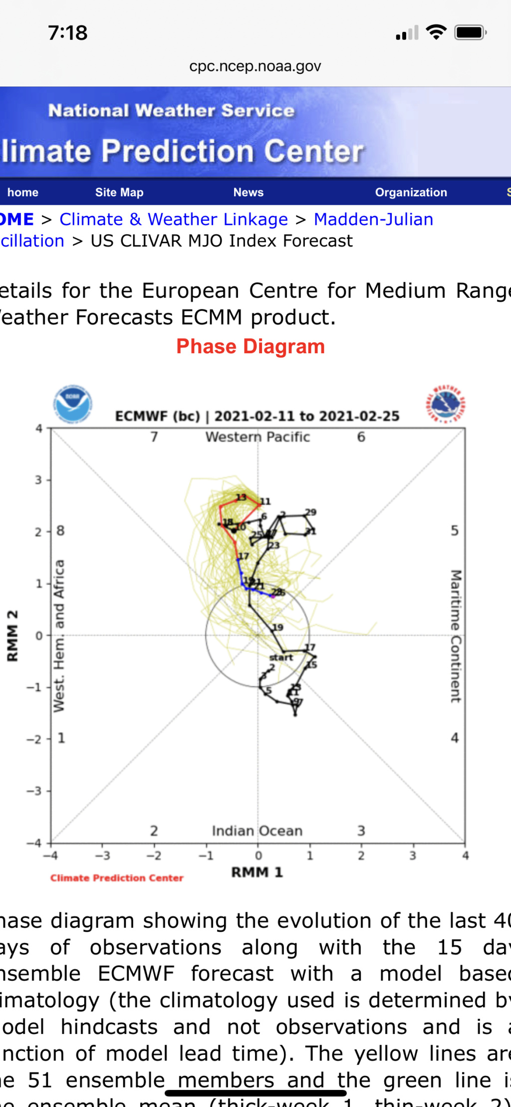
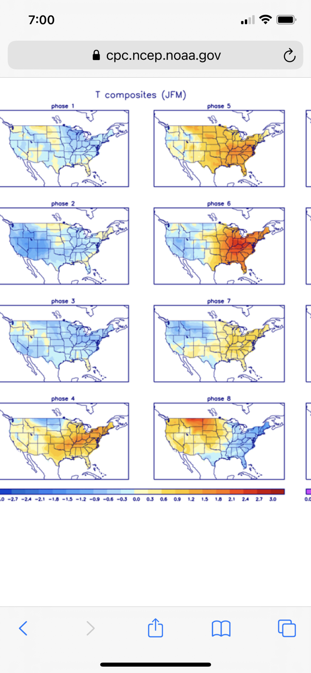
Regarding the ice storm on GFs vs Rain storm on euro i def think the ice storm has a much higher probability of verifying than rain storm does given the thoughts I highlighted last night.
I’ve been texting with a buddy of mine. He was commenting how the models seem to want to show cutters. This was my response.
Yeah. It’s only a matter of time. With the MJO in phase 7 with amplitude coming from phase 6, there is a resistance in the pattern. That and the La Niña, warmer tendencies. The -AO/-NAO has kept it at bay, But it can only last for so long. The Tuesday time frame takes both AO and NAO to neutral to slight pos from a deep negative state before settling back down in a more weak negative state. At least in the means. Sooo does the resistance in the air immediately flip from a track south and east to cutter right off the bat? Personally I don’t think so. That’s why I still think a track on or near the BM is still on the table for Tuesday. Here is the MJO temp tendency composite for January February March. As you can see 6&7 are warm phases. Since January 21st the MJO has been either 6 or 7, But obv it’s been cold thus far.


Regarding the ice storm on GFs vs Rain storm on euro i def think the ice storm has a much higher probability of verifying than rain storm does given the thoughts I highlighted last night.
_________________
"In weather and in life, there's no winning and losing; there's only winning and learning."
WINTER 2012/2013 TOTALS 43.65"WINTER 2017/2018 TOTALS 62.85" WINTER 2022/2023 TOTALS 4.9"
WINTER 2013/2014 TOTALS 64.85"WINTER 2018/2019 TOTALS 14.25" WINTER 2023/2024 TOTALS 13.1"
WINTER 2014/2015 TOTALS 71.20"WINTER 2019/2020 TOTALS 6.35" WINTER 2024/2025 TOTALS 0.00
WINTER 2015/2016 TOTALS 35.00"WINTER 2020/2021 TOTALS 37.75"
WINTER 2016/2017 TOTALS 42.25"WINTER 2021/2022 TOTALS 31.65"

sroc4- Admin

- Posts : 8458
Reputation : 302
Join date : 2013-01-07
Location : Wading River, LI
 Re: Long Range Discussions 21.0
Do you think the amounts of ice being predicted are accurate? I can't remember any accumulations that threatened to shut my area down for days at a time, but from everything the board is saying .5" of ice can cripple a region.
TheAresian- Senior Enthusiast

- Posts : 145
Reputation : 10
Join date : 2019-11-13
Location : Painted Post, NY
 Re: Long Range Discussions 21.0
Aresian. To answer both your questions: regarding the HP placement you’re absolutely correct in that if it’s too far N & or E it could allow our primary to cut cut further N and W.
Regarding the ice. I’m not looking at the totals at all but will say a soln that give many people enough ice to cripple the region is def on the table. The exact totals are probably irrelevant. That’s like asking how many punches on the chin will it take to knock you out. Once you're knocked out it’s irrelevant how many more punches you take on the chin because your already knocked out. Lol. The important thing first is storm track. That will tell the story on who sees ice. As I mentioned last night the cold pool at the surface will hold strong. Much stronger than the mid level cold. CAD(cold air damning). This is why storm track will be so important and why ice is a real threat with this set up. But for whom and exactly how much is irrelevant to me for now.
Regarding the ice. I’m not looking at the totals at all but will say a soln that give many people enough ice to cripple the region is def on the table. The exact totals are probably irrelevant. That’s like asking how many punches on the chin will it take to knock you out. Once you're knocked out it’s irrelevant how many more punches you take on the chin because your already knocked out. Lol. The important thing first is storm track. That will tell the story on who sees ice. As I mentioned last night the cold pool at the surface will hold strong. Much stronger than the mid level cold. CAD(cold air damning). This is why storm track will be so important and why ice is a real threat with this set up. But for whom and exactly how much is irrelevant to me for now.
Last edited by sroc4 on Fri Feb 12, 2021 8:57 am; edited 1 time in total
_________________
"In weather and in life, there's no winning and losing; there's only winning and learning."
WINTER 2012/2013 TOTALS 43.65"WINTER 2017/2018 TOTALS 62.85" WINTER 2022/2023 TOTALS 4.9"
WINTER 2013/2014 TOTALS 64.85"WINTER 2018/2019 TOTALS 14.25" WINTER 2023/2024 TOTALS 13.1"
WINTER 2014/2015 TOTALS 71.20"WINTER 2019/2020 TOTALS 6.35" WINTER 2024/2025 TOTALS 0.00
WINTER 2015/2016 TOTALS 35.00"WINTER 2020/2021 TOTALS 37.75"
WINTER 2016/2017 TOTALS 42.25"WINTER 2021/2022 TOTALS 31.65"

sroc4- Admin

- Posts : 8458
Reputation : 302
Join date : 2013-01-07
Location : Wading River, LI
 Re: Long Range Discussions 21.0
Thank you for answering both questions. As far as the amounts on the ice, like I said before I don't have any experience that I can recall as far as significant ice accumulation. I can remember some "be careful on the sidewalks" today type events, but nothing where there was the threat of lengthy power outages and such. I can't say that for whom is irrelevant to me. I don't worry about myself, but my mom is in her early/mid 80s so the threat of loss of power to her is something about which I care very much.
TheAresian- Senior Enthusiast

- Posts : 145
Reputation : 10
Join date : 2019-11-13
Location : Painted Post, NY
 Re: Long Range Discussions 21.0
TheAresian wrote:Thank you for answering both questions. As far as the amounts on the ice, like I said before I don't have any experience that I can recall as far as significant ice accumulation. I can remember some "be careful on the sidewalks" today type events, but nothing where there was the threat of lengthy power outages and such. I can't say that for whom is irrelevant to me. I don't worry about myself, but my mom is in her early/mid 80s so the threat of loss of power to her is something about which I care very much.
When I said for whom is irrelevant I hope you understand it’s a very broad statement meaning exactly where the ice threat will affect geographically is irrelevant at this lead time on models because they are still changing significantly therefore worrying about my own parents losing power for similar reasons is irrelevant because there is still much uncertainty so why worry yet. Possibility exists for many of us, personally you least of all given your location, so make some basic preparations now to stay ahead of the mob.
_________________
"In weather and in life, there's no winning and losing; there's only winning and learning."
WINTER 2012/2013 TOTALS 43.65"WINTER 2017/2018 TOTALS 62.85" WINTER 2022/2023 TOTALS 4.9"
WINTER 2013/2014 TOTALS 64.85"WINTER 2018/2019 TOTALS 14.25" WINTER 2023/2024 TOTALS 13.1"
WINTER 2014/2015 TOTALS 71.20"WINTER 2019/2020 TOTALS 6.35" WINTER 2024/2025 TOTALS 0.00
WINTER 2015/2016 TOTALS 35.00"WINTER 2020/2021 TOTALS 37.75"
WINTER 2016/2017 TOTALS 42.25"WINTER 2021/2022 TOTALS 31.65"

sroc4- Admin

- Posts : 8458
Reputation : 302
Join date : 2013-01-07
Location : Wading River, LI
weatherwatchermom likes this post
 Re: Long Range Discussions 21.0
sroc4 wrote:...That’s like asking how many punches on the chin will it take to knock you out. Once you're knocked out it’s irrelevant how many more punches you take on the chin because your already knocked out.
That's brilliant. I need to figure out how to apply this great bit of wisdom to my personal life.
You're like the Tony Robbins of NJStrong.

essexcountypete- Pro Enthusiast

- Posts : 783
Reputation : 12
Join date : 2013-12-09
Location : Bloomfield, NJ
 Re: Long Range Discussions 21.0
Assuming a west trajectory of the storm, east of the fall line will rain after a period of time of ice which can be significant due to the antecedent cold surface. I mean SE of I-95 and especially the NJ coast. An easterly fetch will do that. Seen that time and again what easterly winds do surface temps east of the Fall Line. You can just look at the surface freezing line on mesoscale analysis and know where the Fall Line is.
The interior is in for severe icing if this is westward. Easterly fetch won't warm the surface above freezing and won't even be close. If it's one thing EPA is good at it's icing situations especially IMBY at 600' ASL.
The way I'm seeing things now which no doubt will change my best case scenario is deeper layer of sub freezing temps in the mid-levels to keep this more IP than ZR.
All subject to change, but I really am concerned with this setup.
heehaw453- Advanced Forecaster

- Posts : 3931
Reputation : 86
Join date : 2014-01-20
Location : Bedminster Township, PA Elevation 600' ASL
sroc4 likes this post
 Re: Long Range Discussions 21.0
essexcountypete wrote:sroc4 wrote:...That’s like asking how many punches on the chin will it take to knock you out. Once you're knocked out it’s irrelevant how many more punches you take on the chin because your already knocked out.
That's brilliant. I need to figure out how to apply this great bit of wisdom to my personal life.
You're like the Tony Robbins of NJStrong.

 Thanks
Its amazing how long that guy has been around.
_________________
"In weather and in life, there's no winning and losing; there's only winning and learning."
WINTER 2012/2013 TOTALS 43.65"WINTER 2017/2018 TOTALS 62.85" WINTER 2022/2023 TOTALS 4.9"
WINTER 2013/2014 TOTALS 64.85"WINTER 2018/2019 TOTALS 14.25" WINTER 2023/2024 TOTALS 13.1"
WINTER 2014/2015 TOTALS 71.20"WINTER 2019/2020 TOTALS 6.35" WINTER 2024/2025 TOTALS 0.00
WINTER 2015/2016 TOTALS 35.00"WINTER 2020/2021 TOTALS 37.75"
WINTER 2016/2017 TOTALS 42.25"WINTER 2021/2022 TOTALS 31.65"

sroc4- Admin

- Posts : 8458
Reputation : 302
Join date : 2013-01-07
Location : Wading River, LI
 Re: Long Range Discussions 21.0
heehaw453 wrote:Assuming a west trajectory of the storm, east of the fall line will rain after a period of time of ice which can be significant due to the antecedent cold surface. I mean SE of I-95 and especially the NJ coast. An easterly fetch will do that. Seen that time and again what easterly winds do surface temps east of the Fall Line. You can just look at the surface freezing line on mesoscale analysis and know where the Fall Line is.
The interior is in for severe icing if this is westward. Easterly fetch won't warm the surface above freezing and won't even be close. If it's one thing EPA is good at it's icing situations especially IMBY at 600' ASL.
The way I'm seeing things now which no doubt will change my best case scenario is deeper layer of sub freezing temps in the mid-levels to keep this more IP than ZR.
All subject to change, but I really am concerned with this setup.
Great points
_________________
"In weather and in life, there's no winning and losing; there's only winning and learning."
WINTER 2012/2013 TOTALS 43.65"WINTER 2017/2018 TOTALS 62.85" WINTER 2022/2023 TOTALS 4.9"
WINTER 2013/2014 TOTALS 64.85"WINTER 2018/2019 TOTALS 14.25" WINTER 2023/2024 TOTALS 13.1"
WINTER 2014/2015 TOTALS 71.20"WINTER 2019/2020 TOTALS 6.35" WINTER 2024/2025 TOTALS 0.00
WINTER 2015/2016 TOTALS 35.00"WINTER 2020/2021 TOTALS 37.75"
WINTER 2016/2017 TOTALS 42.25"WINTER 2021/2022 TOTALS 31.65"

sroc4- Admin

- Posts : 8458
Reputation : 302
Join date : 2013-01-07
Location : Wading River, LI
 Re: Long Range Discussions 21.0
Hi everyone -
I renamed the valentines thread to talk about the weather impacts for this weekend and early next week. It seems like this is turning into one long day where every day between Saturday and Sunday will precipitate some form of snow, sleet, freezing rain, and rain. It's going to be annoying...
Keep this thread going for the storm system shown for next Thursday-Friday
I leave for Florida on an evening flight next Friday. I fully expect that storm to turn into a Roidzilla.
_________________
_______________________________________________________________________________________________________
CLICK HERE to view NJ Strong Snowstorm Classifications
amugs likes this post
 Re: Long Range Discussions 21.0
Frank_Wx wrote:Hi everyone -
I renamed the valentines thread to talk about the weather impacts for this weekend and early next week. It seems like this is turning into one long day where every day between Saturday and Sunday will precipitate some form of snow, sleet, freezing rain, and rain. It's going to be annoying...
Keep this thread going for the storm system shown for next Thursday-Friday
I leave for Florida on an evening flight next Friday. I fully expect that storm to turn into a Roidzilla.
And Tuesday Im assuming, or do you want to start a new thread for that?
_________________
"In weather and in life, there's no winning and losing; there's only winning and learning."
WINTER 2012/2013 TOTALS 43.65"WINTER 2017/2018 TOTALS 62.85" WINTER 2022/2023 TOTALS 4.9"
WINTER 2013/2014 TOTALS 64.85"WINTER 2018/2019 TOTALS 14.25" WINTER 2023/2024 TOTALS 13.1"
WINTER 2014/2015 TOTALS 71.20"WINTER 2019/2020 TOTALS 6.35" WINTER 2024/2025 TOTALS 0.00
WINTER 2015/2016 TOTALS 35.00"WINTER 2020/2021 TOTALS 37.75"
WINTER 2016/2017 TOTALS 42.25"WINTER 2021/2022 TOTALS 31.65"

sroc4- Admin

- Posts : 8458
Reputation : 302
Join date : 2013-01-07
Location : Wading River, LI
 Re: Long Range Discussions 21.0
Taken verbatim the 12z NAM if it went out further would be rain for most
_________________
"In weather and in life, there's no winning and losing; there's only winning and learning."
WINTER 2012/2013 TOTALS 43.65"WINTER 2017/2018 TOTALS 62.85" WINTER 2022/2023 TOTALS 4.9"
WINTER 2013/2014 TOTALS 64.85"WINTER 2018/2019 TOTALS 14.25" WINTER 2023/2024 TOTALS 13.1"
WINTER 2014/2015 TOTALS 71.20"WINTER 2019/2020 TOTALS 6.35" WINTER 2024/2025 TOTALS 0.00
WINTER 2015/2016 TOTALS 35.00"WINTER 2020/2021 TOTALS 37.75"
WINTER 2016/2017 TOTALS 42.25"WINTER 2021/2022 TOTALS 31.65"

sroc4- Admin

- Posts : 8458
Reputation : 302
Join date : 2013-01-07
Location : Wading River, LI
 Re: Long Range Discussions 21.0
Of course it would, this is next Thurs/Fri? We wont even have time to recover if we get a ice storm like might be projected. This has def been a feb of non-stop tracking! Have fun in FL.Frank_Wx wrote:Hi everyone -
I renamed the valentines thread to talk about the weather impacts for this weekend and early next week. It seems like this is turning into one long day where every day between Saturday and Sunday will precipitate some form of snow, sleet, freezing rain, and rain. It's going to be annoying...
Keep this thread going for the storm system shown for next Thursday-Friday
I leave for Florida on an evening flight next Friday. I fully expect that storm to turn into a Roidzilla.

jmanley32- Senior Enthusiast

- Posts : 20645
Reputation : 108
Join date : 2013-12-12
Age : 43
Location : Yonkers, NY
 Re: Long Range Discussions 21.0
Honestly I would rather it miss completely than have frz or rain, a wide right. But doesn't look possible.sroc4 wrote:Taken verbatim the 12z NAM if it went out further would be rain for most

jmanley32- Senior Enthusiast

- Posts : 20645
Reputation : 108
Join date : 2013-12-12
Age : 43
Location : Yonkers, NY
elkiehound likes this post
 Re: Long Range Discussions 21.0
Looks like tues is a rain storm now
frank 638- Senior Enthusiast

- Posts : 2879
Reputation : 37
Join date : 2016-01-01
Age : 41
Location : bronx ny
 Re: Long Range Discussions 21.0
Mother Nature giveth and Mother Nature taketh away. Snow pack is going to take a beating by the end of next week.
TheAresian- Senior Enthusiast

- Posts : 145
Reputation : 10
Join date : 2019-11-13
Location : Painted Post, NY
 Re: Long Range Discussions 21.0
If we lose the -AO/-NAO in a La Nina in February then sig snowfall most likely isn't going to occur around here. Then it'll be confined to CNE/NNE and upstate NY. The WAR will flex its muscles and then we go to a cutter pattern like what would have occurred had we not had the help from the arctic.
My take is to hope the -NAM state can load up again for end of February and into March then maybe we have a shot to go out in style. But if that doesn't occur, then I'd say not too much unless we get a very fortuitous setup in a short window.
My take is to hope the -NAM state can load up again for end of February and into March then maybe we have a shot to go out in style. But if that doesn't occur, then I'd say not too much unless we get a very fortuitous setup in a short window.
heehaw453- Advanced Forecaster

- Posts : 3931
Reputation : 86
Join date : 2014-01-20
Location : Bedminster Township, PA Elevation 600' ASL
Page 8 of 15 •  1 ... 5 ... 7, 8, 9 ... 11 ... 15
Page 8 of 15
Permissions in this forum:
You cannot reply to topics in this forum
 Home
Home