Long Range Thread 25.0
Page 29 of 40 •  1 ... 16 ... 28, 29, 30 ... 34 ... 40
 Re: Long Range Thread 25.0
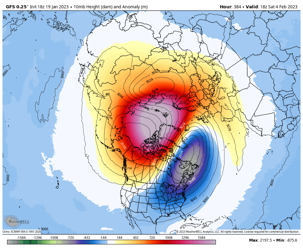
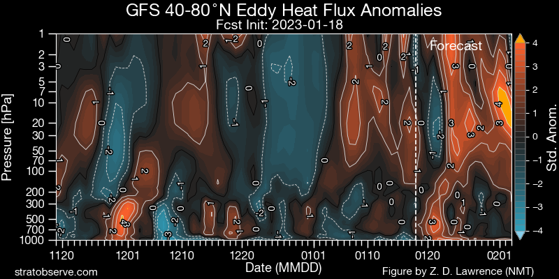
For the #PolarVortex (PV) the hits keep coming with the best yet to come from upwelling wave energy from the troposphere. What does this mean for the PV & the impact on our weather? It's serious when I dust off the six-step snow model. The blog now public: https://t.co/Gg8N2KIjJS pic.twitter.com/KBya32hZrn
— Judah Cohen (@judah47) January 18, 2023
This is along that Frank and I have been posting here for a while now. Dr. Lee and Butler are on this as well.
Cohen said, "I am not predicting a split just ....yet"!! That would be interesting if it happens for midish for late Feb.
Time will tell
amugs- Advanced Forecaster - Mod

- Posts : 15145
Join date : 2013-01-07
 Re: Long Range Thread 25.0
_________________
_______________________________________________________________________________________________________
CLICK HERE to view NJ Strong Snowstorm Classifications
 Re: Long Range Thread 25.0
_________________
_______________________________________________________________________________________________________
CLICK HERE to view NJ Strong Snowstorm Classifications
CPcantmeasuresnow and hyde345 like this post
 Re: Long Range Thread 25.0
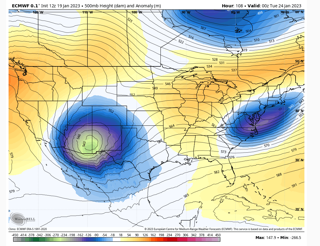
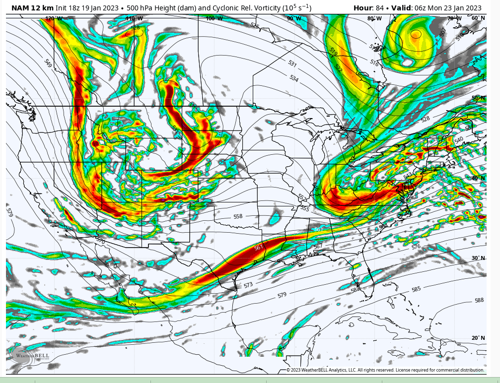
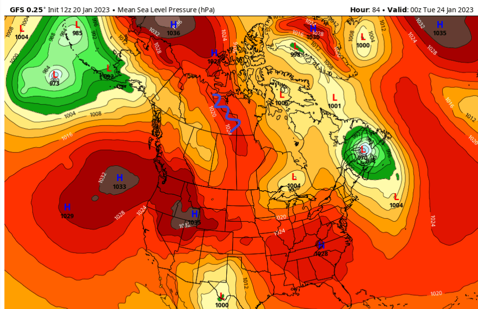
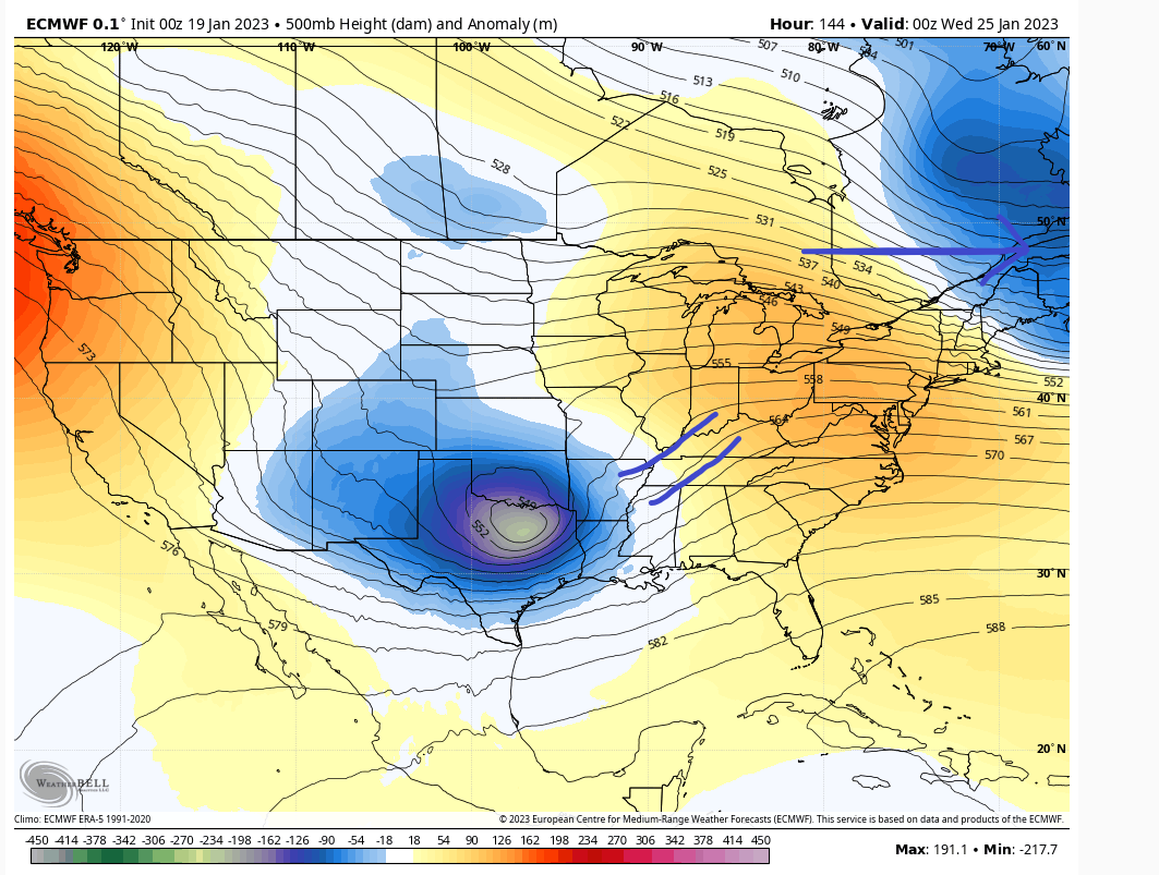
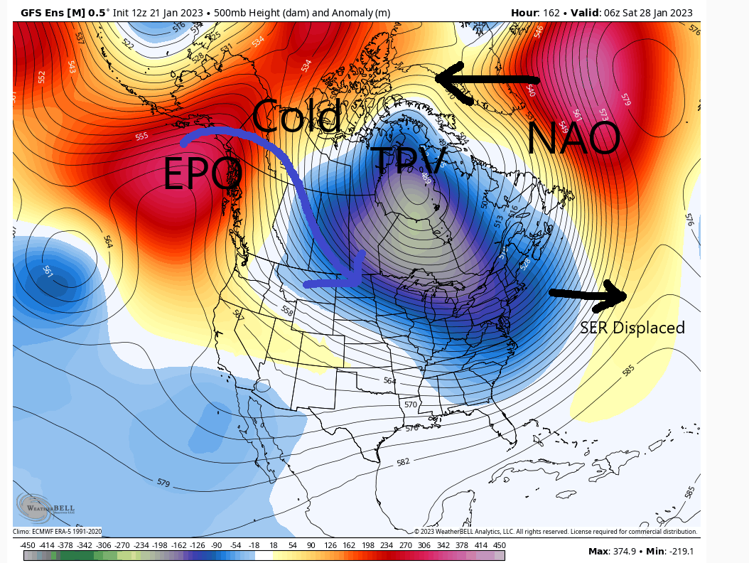
I don't think Monday storm will cut. There's not enough space between the s/w for this to blow up in January. You see the ULL deamplify as it moves east Figure A. What has plagued us this entire winter will do so again is the antecedent ridge warming the boundary levels. There simply isn't enough cold air to render snow on the coast and even inland it's not ideal. I am skeptical of 1/25 threat too with a potent s/w like you see in AZ. The only way I see that working out is if somehow heights get lowered to our north by the TPV as in Figure B.Frank_Wx wrote:Based off some research…I think N&W of NYC is going to see one heck of a snowy February. That’s not to say the coast will not see snow - they will at some point - but we’re seeing indications of a potent Pacific wave similar (but stronger) to the one we saw back in December. This will completely dismantle the Strat PV (SSWE). The first development will be a -EPO ridge that eventually becomes a -WPO ridge. Next will be a -NAO, but I’m thinking more east-based. Normally this type of 500mb setup favors N&W. That said, there will be arctic cold across the northern US and it won’t take much for that to bleed southeast. Mondays storm will likely cut west and send the cold air to the coast, setting us up for Wednesday. I think that’s the only way the coast can win right now (addition by subtraction)
Figure A
Monday
S/W close and UL energy will deamplify track will be inside BM but air mass is not ideal Would need an additional push east and intensification as it moves to our east to cool boundary layer. Doubt it.
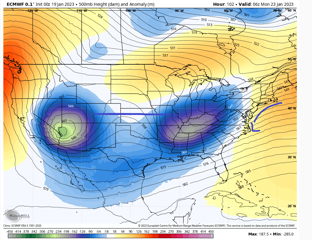
Figure B
Wednesday dampened heights start to rise as the trough above pulls away. That leads to an inland track. Unless we get confluence in that area I'm skeptical.
heehaw453- Advanced Forecaster

- Posts : 3926
Reputation : 86
Join date : 2014-01-20
Location : Bedminster Township, PA Elevation 600' ASL
 Re: Long Range Thread 25.0
heehaw453- Advanced Forecaster

- Posts : 3926
Reputation : 86
Join date : 2014-01-20
Location : Bedminster Township, PA Elevation 600' ASL
 Re: Long Range Thread 25.0
heehaw453 wrote:I'll say one more thing on the Monday storm. A setup what Euro is showing would be 6"+ snow for I95 on a decent year. One where there was cold air around. But this year is another animal as y'all know. The only thing that can give I95 a shot for a few weeks is the TPV placement and movement. But until you get your first snowfall skepticism must remain. NYC will very likely be #2 in the longest its taken for measurable snowfall and yes it's possible it beats the January 28 date, albeit I think something works out before that date. Some how some way...
Will continue to go with the mindset of what we use to refer to as winter. “Expect little, get even less”

CPcantmeasuresnow- Wx Statistician Guru

- Posts : 7281
Reputation : 230
Join date : 2013-01-07
Age : 103
Location : Eastern Orange County, NY
sroc4, Grselig and heehaw453 like this post
heehaw453- Advanced Forecaster

- Posts : 3926
Reputation : 86
Join date : 2014-01-20
Location : Bedminster Township, PA Elevation 600' ASL
heehaw453- Advanced Forecaster

- Posts : 3926
Reputation : 86
Join date : 2014-01-20
Location : Bedminster Township, PA Elevation 600' ASL
 Re: Long Range Thread 25.0

Can the GEFS help out NW and I95?? It shifted a good 50 miles SE but again the airmass is terrible for this time of year, Ocean temps running AN not helping at all!!

Watch this reverse as we get ready for the latter part of Feb through April and ruins Spring!!!
_________________
Mugs
AKA:King: Snow Weenie
Self Proclaimed
WINTER 2014-15 : 55.12" +.02 for 6 coatings (avg. 35")
WINTER 2015-16 Total - 29.8" (Avg 35")
WINTER 2016-17 : 39.5" so far

amugs- Advanced Forecaster - Mod

- Posts : 15145
Reputation : 213
Join date : 2013-01-07
Age : 54
Location : Hillsdale,NJ
heehaw453- Advanced Forecaster

- Posts : 3926
Reputation : 86
Join date : 2014-01-20
Location : Bedminster Township, PA Elevation 600' ASL
 Re: Long Range Thread 25.0
MattyICE- Advanced Forecaster

- Posts : 249
Reputation : 6
Join date : 2017-11-10
Age : 39
Location : Clifton, NJ (Eastern Passaic County)
heehaw453, weatherwatchermom and phil155 like this post
 Re: Long Range Thread 25.0
_________________
Mugs
AKA:King: Snow Weenie
Self Proclaimed
WINTER 2014-15 : 55.12" +.02 for 6 coatings (avg. 35")
WINTER 2015-16 Total - 29.8" (Avg 35")
WINTER 2016-17 : 39.5" so far

amugs- Advanced Forecaster - Mod

- Posts : 15145
Reputation : 213
Join date : 2013-01-07
Age : 54
Location : Hillsdale,NJ
 Re: Long Range Thread 25.0
_________________
Mugs
AKA:King: Snow Weenie
Self Proclaimed
WINTER 2014-15 : 55.12" +.02 for 6 coatings (avg. 35")
WINTER 2015-16 Total - 29.8" (Avg 35")
WINTER 2016-17 : 39.5" so far

amugs- Advanced Forecaster - Mod

- Posts : 15145
Reputation : 213
Join date : 2013-01-07
Age : 54
Location : Hillsdale,NJ
CPcantmeasuresnow likes this post
 Re: Long Range Thread 25.0

Irish- Pro Enthusiast

- Posts : 788
Reputation : 19
Join date : 2019-01-16
Age : 46
Location : Old Bridge, NJ
phil155 likes this post
 Re: Long Range Thread 25.0
_________________
_______________________________________________________________________________________________________
CLICK HERE to view NJ Strong Snowstorm Classifications
CPcantmeasuresnow and Irish like this post
 Re: Long Range Thread 25.0
_________________
Mugs
AKA:King: Snow Weenie
Self Proclaimed
WINTER 2014-15 : 55.12" +.02 for 6 coatings (avg. 35")
WINTER 2015-16 Total - 29.8" (Avg 35")
WINTER 2016-17 : 39.5" so far

amugs- Advanced Forecaster - Mod

- Posts : 15145
Reputation : 213
Join date : 2013-01-07
Age : 54
Location : Hillsdale,NJ
CPcantmeasuresnow likes this post
 Re: Long Range Thread 25.0
The only reason Wednesday has a shot for frozen is because as progged we may get lucky with a very well placed, but unfort weaker H to pump in just enough cold air for white gold. This highly favors NW of I95. If you are coastal I wouldn't expect much. WAA is normally going to warm nose much more than what models suggest. It takes just one layer to taint the snow. If Wednesday storm had a track like Monday storm then sig snow would have been possible. But this is what it is.

heehaw453- Advanced Forecaster

- Posts : 3926
Reputation : 86
Join date : 2014-01-20
Location : Bedminster Township, PA Elevation 600' ASL
 Re: Long Range Thread 25.0
I could see places where I am getting a couple of inches of sloppy snow out of both systems but that does not a winter make. This looks similar to mid December when we had 2-3 sloppy inches that covered the ground for several days. A non winter event for the coastal plain for now. Soon we move from Wall to Wing, I prefer when there was Winter.

CPcantmeasuresnow- Wx Statistician Guru

- Posts : 7281
Reputation : 230
Join date : 2013-01-07
Age : 103
Location : Eastern Orange County, NY
 Re: Long Range Thread 25.0
Well said. Personally winter has been telling me since December's NAO link to the SER where things stand. I just have been stubbornly not wanting to listen. And at this point I'm going to need to see decent snow on the ground to believe otherwise.CPcantmeasuresnow wrote:When the trend is in place you don’t fight it. You could go broke fighting trends in the stock market and you could go insane fighting trends in a horrible weather pattern
I could see places where I am getting a couple of inches of sloppy snow out of both systems but that does not a winter make. This looks similar to mid December when we had 2-3 sloppy inches that covered the ground for several days. A non winter event for the coastal plain for now. Soon we move from Wall to Wing, I prefer when there was Winter.
heehaw453- Advanced Forecaster

- Posts : 3926
Reputation : 86
Join date : 2014-01-20
Location : Bedminster Township, PA Elevation 600' ASL
heehaw453- Advanced Forecaster

- Posts : 3926
Reputation : 86
Join date : 2014-01-20
Location : Bedminster Township, PA Elevation 600' ASL
 Re: Long Range Thread 25.0
# of Sudden Stratospheric Warming events during ENSO phases. More frequent during La Nina in the months of January and February. pic.twitter.com/ddyExvLNgx
— Spot On Weather (@eulermatthew4) January 20, 2023
Interesting
_________________
Mugs
AKA:King: Snow Weenie
Self Proclaimed
WINTER 2014-15 : 55.12" +.02 for 6 coatings (avg. 35")
WINTER 2015-16 Total - 29.8" (Avg 35")
WINTER 2016-17 : 39.5" so far

amugs- Advanced Forecaster - Mod

- Posts : 15145
Reputation : 213
Join date : 2013-01-07
Age : 54
Location : Hillsdale,NJ
 Re: Long Range Thread 25.0
Frank_Wx wrote:Based off some research…I think N&W of NYC is going to see one heck of a snowy February. That’s not to say the coast will not see snow - they will at some point - but we’re seeing indications of a potent Pacific wave similar (but stronger) to the one we saw back in December. This will completely dismantle the Strat PV (SSWE). The first development will be a -EPO ridge that eventually becomes a -WPO ridge. Next will be a -NAO, but I’m thinking more east-based. Normally this type of 500mb setup favors N&W. That said, there will be arctic cold across the northern US and it won’t take much for that to bleed southeast. Mondays storm will likely cut west and send the cold air to the coast, setting us up for Wednesday. I think that’s the only way the coast can win right now (addition by subtraction)
Update: Anomalous WPO ridge is prevalent on both the GEFS and EPS
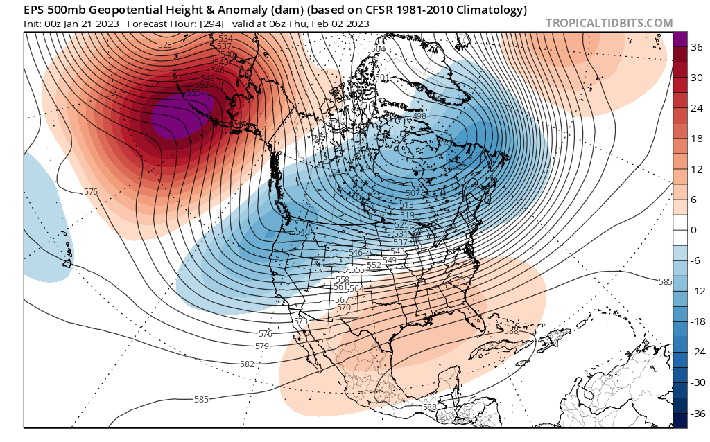
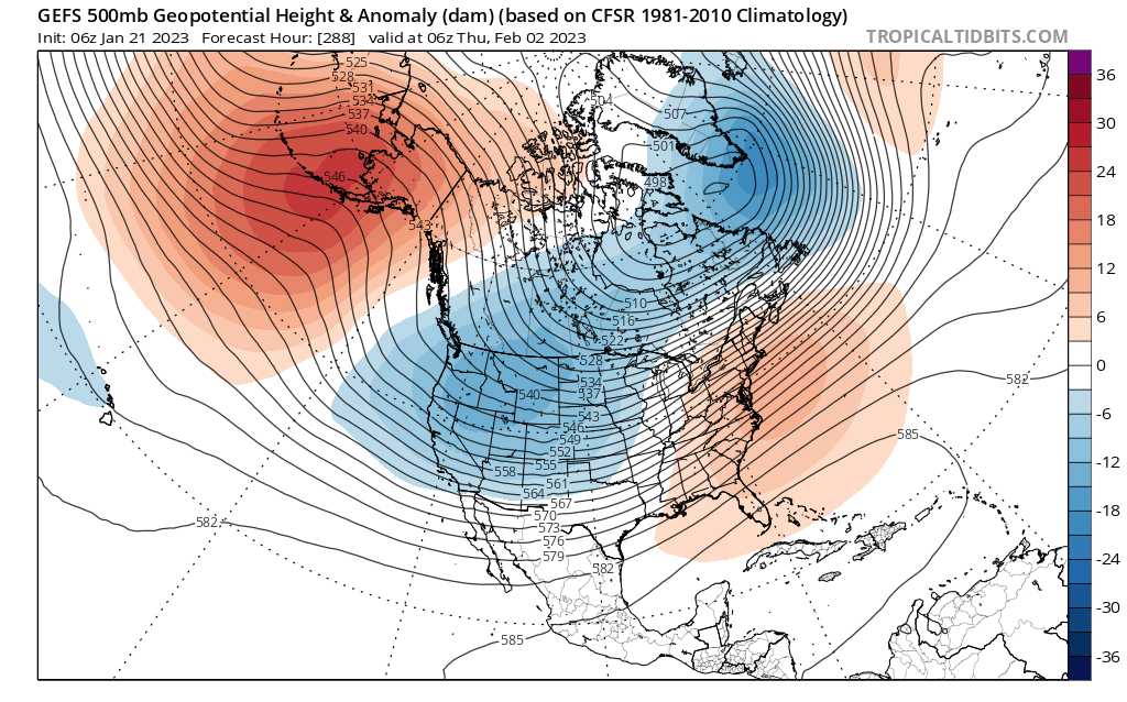
The date we see this ridge develop I’m thinking January 30th +/- 3 days. The next shoe to drop is the east based -NAO. Unfortunately that could take until the second or third week of February. Regardless, we’re staring at intense cold come February. The storm tracks will favor N&W until we see Atlantic blocking, either in the form of a -NAO, nicely placed HP, or 50/50 confluence.
_________________
_______________________________________________________________________________________________________
CLICK HERE to view NJ Strong Snowstorm Classifications
oldtimer likes this post
 Re: Long Range Thread 25.0
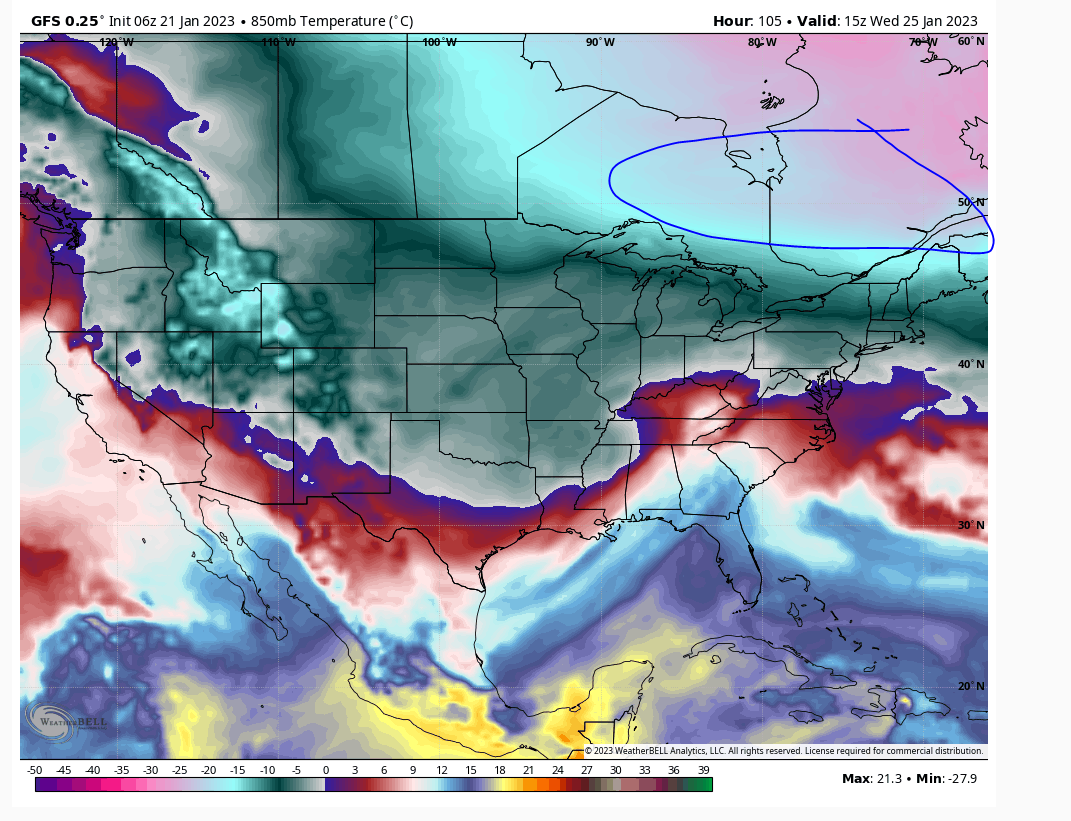
Picture B is showing mid-level temps and when you see pink that is tremendously cold air. If it pushes any further than modelled there will be frozen with this. The column will still taint as the storm approaches, but plain rain will take a longer time especially NW of I95. So it's possible NW of I95 sees several inches of snow/sleet/graupel/etc...
Picture A
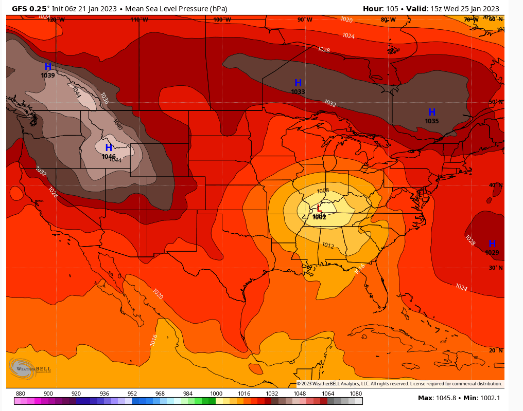
Picture B
heehaw453- Advanced Forecaster

- Posts : 3926
Reputation : 86
Join date : 2014-01-20
Location : Bedminster Township, PA Elevation 600' ASL
Frank_Wx likes this post
 Re: Long Range Thread 25.0
heehaw453- Advanced Forecaster

- Posts : 3926
Reputation : 86
Join date : 2014-01-20
Location : Bedminster Township, PA Elevation 600' ASL
 Re: Long Range Thread 25.0
https://www.nymetroweather.com/2023/01/21/nyc-approaching-record-breaking-snowless-start-to-winter/
JT33- Posts : 42
Reputation : 0
Join date : 2022-01-25
Location : Piscataway
 Re: Long Range Thread 25.0
Oh yeah. Probably better in the January discussions thread. But we're all over this one. CPK may escape infamy with a c-1" on Wednesday before precip flips to rain. Going to be close and the way this winter has evolved i'd put the probability greater than .5 (50%) that CPK breaks the record even though based on model guidance they shouldn't.JT33 wrote:This is just an FYI type of thing - came across the article just now when I opened my computer. Not sure if this is the proper location to link such things.
https://www.nymetroweather.com/2023/01/21/nyc-approaching-record-breaking-snowless-start-to-winter/
heehaw453- Advanced Forecaster

- Posts : 3926
Reputation : 86
Join date : 2014-01-20
Location : Bedminster Township, PA Elevation 600' ASL
CPcantmeasuresnow, SENJsnowman and JT33 like this post
Page 29 of 40 •  1 ... 16 ... 28, 29, 30 ... 34 ... 40

 Home
Home

