
 Search
Long Range Thread 27.0
Page 11 of 40 •  1 ... 7 ... 10, 11, 12 ... 25 ... 40
 ![]()
Re: Long Range Thread 27.0
![]() by rb924119 Tue Dec 12, 2023 11:18 pm
by rb924119 Tue Dec 12, 2023 11:18 pm
Last edited by rb924119 on Tue Dec 12, 2023 11:41 pm; edited 1 time in total
rb924119- Meteorologist

- Posts : 7033
Join date : 2013-02-06
amugs, kalleg and Irish like this post
Re: Long Range Thread 27.0
![]() by rb924119 Tue Dec 12, 2023 11:26 pm
by rb924119 Tue Dec 12, 2023 11:26 pm
sroc4 wrote:rb924119 wrote:sroc4 wrote:heehaw453 wrote:rb924119 wrote:In addendum to the above, the modeling is not going to be able to accurately reflect the dynamics in play at this stage, so aspects such as dynamical cooling, as well as the scope and intensity of the precipitation shield, won't really be "seen" yet, especially by lower-resolution ensembles. However, this is part of the reason why I think we start to see the models "trend" to a bigger snow threat in coming runs.
Great job and highly appreciated! Very comprehensive and sound reasoning. I'm too old school in my thoughts. I'm one of those that need to see a big dome of cold air in place kind of folks. I do agree with you n/s injection of the cold air could trend this colder but I think for sig snow threat that'd benefit folks deeper into NY State and CNE/NNE. If we had a fresh injection of cold before this thing arrived I'd be on board for more of the immediate area. But you definitely have my interest piqued.
Ray I have not had a chance to watch the video yet to hear the details, but since you mention things like dynamic cooling and scope and intensity of precip shield etc. I have to throw my two cents in. First let me lead with what Im about to say is about as general a statement as possible since we all know anything that involves any sort of surface details at this lead time is almost entirely useless.
That said there has to be a huge fundamental shift in how the modeling is being handled, operational and ensembles alike, regarding the 500mb set up for this. As it stands now this system comes up and is 100% southern stream. And because it is so amped up from its inception in the SW CONUS, the southern energy that will give birth to this threat, as it traverses the southern tear pf the country, raises heights out ahead with exceptional voracity. This not only resuts in a very warm antecedant air mass well into NE, but also raises dew points exceptionally high throughout NE. As it stands now as the system reaches our latitude there isnt a below freezing DP in the the NE USA, making any discussion about dynamic cooling regardless of how intense the precip banding becomes pretty much a mute point for most of the area. On top of that the 850-925mb level are torched.
Now again do not think for a second I dont recognize that the details of the three images I just showed wont change, but the point Im trying to make is that fundamentally unless we see a major shift in how these models are handling the 500mb pattern north of the boarder even if this trends cooler it wont be enough for 98% of the people on this board. Without a linkage with the northern stream min 24hrs earlier this will remain warm for pretty much all. That said it does appear that on the ensembles there has been a slow trend towards closer interactions between the N and S streams, but there is still a very long way to go.
I don’t disagree with anything you said here, brother. But I think when you watch my video, it’ll all make sense. In short, I think that we will see a much sooner, stronger interaction with incoming northern stream energy, which will not only work to amp up our storm even more, but also deliver fresh cold air and low-level nigh pressure to the west, northwest, and north of the bombing cyclone as it moves up the coast. This would only help to deliver cold air more efficiently to the system. Anyway, I am curious to hear your thoughts after you watch haha
Great Video Ray. I finally had a chance to listen. You make a few Very interesting points. Particularly when you discuss how the ridging north of 40n since it all connects adds momentum on the N side and takes momentum away along the subtropic side. This is an interesting mechanism as to how things slow down a bit. I am still not sold however on the idea as a whole that the northern energy will be enough because when you start to zoom in on the N hemisphere anomaly maps, even simply the N American view you realize there is nuance. My contention is that extremely strong northern Jet is the door shut to the cold air and it’s my opinion that there won’t be enough to open the door enough to allow the cold air in. I don’t doubt that the models will trend colder but I’m not ready to buy into the idea of anywhere further s and e than the map I drew with the prev storm gets in on meaningful action. But again great video and thank you for taking that time. I learn something new every time.


Thanks, brother Scott! You may very well be right, only time is going to tell us haha forecasting is largely subjective to begin with, and based on the most recent guidance, you’re right to say that there isn’t really any cold air close by. My whole thing is trying to predict where the modeling (and therefore, the end result) is going to end up. And in most cases, the strong northern jet usually is a killer, but in this case, I think it’s the opposite. It’s gonna be fun to track for sure, and I’m definitely looking forward to the discussion as subsequent runs come in!
rb924119- Meteorologist
- Posts : 7033
Join date : 2013-02-06
Re: Long Range Thread 27.0
![]() by Irish Wed Dec 13, 2023 6:24 am
by Irish Wed Dec 13, 2023 6:24 am

Irish- Pro Enthusiast

- Posts : 788
Reputation : 19
Join date : 2019-01-16
Age : 46
Location : Old Bridge, NJ
Re: Long Range Thread 27.0
![]() by Frank_Wx Wed Dec 13, 2023 6:56 am
by Frank_Wx Wed Dec 13, 2023 6:56 am

Normally when we talk triple phase in the middle of December, this forums entire appearance changes to storm mode and I’m calling for a Roidzilla. Sadly I’m not sure that will be the case this time around. The Pacific energy is too potent - hence all the Pacific jet extension talk the last two days - as it attempts to close off over the Central part of the country which raises heights along the east coast. It may even try to partially phase with northern energy and turn into a big vortex, which ends up tracking east to phase with the STJ energy. The 500mb setup just doesn’t feel right for snow in my opinion. When both the AO and NAO are positive, it normally means there isn’t enough cold air / enough wave length that allows east coast storms to bomb out.
_________________
_______________________________________________________________________________________________________
CLICK HERE to view NJ Strong Snowstorm Classifications

Frank_Wx- Godzilla Seeker

- Posts : 21311
Reputation : 328
Join date : 2013-01-05
Age : 32
Location : Jersey City, NJ -

docstox12, rb924119 and MattyICE like this post
Re: Long Range Thread 27.0
![]() by jmanley32 Wed Dec 13, 2023 7:31 am
by jmanley32 Wed Dec 13, 2023 7:31 am

jmanley32- Senior Enthusiast

- Posts : 20637
Reputation : 108
Join date : 2013-12-12
Age : 43
Location : Yonkers, NY
Re: Long Range Thread 27.0
![]() by nutleyblizzard Wed Dec 13, 2023 7:42 am
by nutleyblizzard Wed Dec 13, 2023 7:42 am

nutleyblizzard- Senior Enthusiast
- Posts : 1963
Reputation : 41
Join date : 2014-01-30
Age : 58
Location : Nutley, new jersey
Re: Long Range Thread 27.0
![]() by jmanley32 Wed Dec 13, 2023 8:04 am
by jmanley32 Wed Dec 13, 2023 8:04 am
yup snd the cmc and euro showed 4 to 5 inches with more high winds. Even i dont care as much sbout that. Its only fun in snow cuz you can go out in it.nutleyblizzard wrote:There’s just no arctic air available on our side of the globe. Just marginally cool air. That’s not going to get it done even with a benchmark track. Our only hope is that the storm really bombs out to produce its own cold air but that rarely works out for us. On a good note like Ray said on his video, at the very least this storm will help to kickstart the overall pattern into a more colder regime; Christmas week into the new year. We just need to be a little more patient, although I have to admit these ongoing rainstorms are starting to tick me off.
jmanley32- Senior Enthusiast
- Posts : 20637
Reputation : 108
Join date : 2013-12-12
Age : 43
Location : Yonkers, NY
Re: Long Range Thread 27.0
![]() by jmanley32 Wed Dec 13, 2023 8:06 am
by jmanley32 Wed Dec 13, 2023 8:06 am
i thonk ray or scott said it that dont focus on temps this far out. It will chsnge for better or worse.Irish wrote:Looks like temps have edged a little warmer for the 18th. Looks like a threat for lots of rain from the 17th onward for a couple days.
jmanley32- Senior Enthusiast
- Posts : 20637
Reputation : 108
Join date : 2013-12-12
Age : 43
Location : Yonkers, NY
Re: Long Range Thread 27.0
![]() by amugs Wed Dec 13, 2023 8:26 am
by amugs Wed Dec 13, 2023 8:26 am
rb924119 wrote:Synopsis of 00z runs so far: GFS is too high and tight with the storm track, should be further southeast. GEM verbatim arguably is the width of a wheaties flake away from one of the biggest snow storms we could ever see, especially for the interior lol I’ll take it!
GEM verbatim arguably is the width of a wheaties flake away from one of the biggest snow storms we could ever see, especially for the interior lol I’ll take it!
Maybe the quote of the winter LOL!!
Okay here comes the MJO wave we are all chomping at the bit for?
Phase 8 by Xmass Time frame which gives us this:
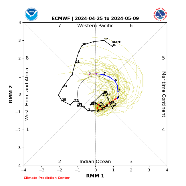

Last edited by amugs on Wed Dec 13, 2023 8:34 am; edited 1 time in total
_________________
Mugs
AKA:King: Snow Weenie
Self Proclaimed
WINTER 2014-15 : 55.12" +.02 for 6 coatings (avg. 35")
WINTER 2015-16 Total - 29.8" (Avg 35")
WINTER 2016-17 : 39.5" so far

amugs- Advanced Forecaster - Mod

- Posts : 15130
Reputation : 213
Join date : 2013-01-07
Age : 54
Location : Hillsdale,NJ
rb924119 and Irish like this post
Re: Long Range Thread 27.0
![]() by amugs Wed Dec 13, 2023 8:32 am
by amugs Wed Dec 13, 2023 8:32 am


MEH

Double MEH

_________________
Mugs
AKA:King: Snow Weenie
Self Proclaimed
WINTER 2014-15 : 55.12" +.02 for 6 coatings (avg. 35")
WINTER 2015-16 Total - 29.8" (Avg 35")
WINTER 2016-17 : 39.5" so far
amugs- Advanced Forecaster - Mod
- Posts : 15130
Reputation : 213
Join date : 2013-01-07
Age : 54
Location : Hillsdale,NJ
Re: Long Range Thread 27.0
![]() by rb924119 Wed Dec 13, 2023 8:37 am
by rb924119 Wed Dec 13, 2023 8:37 am
amugs wrote:rb924119 wrote:Synopsis of 00z runs so far: GFS is too high and tight with the storm track, should be further southeast. GEM verbatim arguably is the width of a wheaties flake away from one of the biggest snow storms we could ever see, especially for the interior lol I’ll take it!
GEM verbatim arguably is the width of a wheaties flake away from one of the biggest snow storms we could ever see, especially for the interior lol I’ll take it!
Maybe the quote of the winter LOL!!
Okay here comes the MJO wave we are all chomping at the bit for?
Phase 8 by Xmass Time frame which gives us this:
Trust the process, mugsy haha
rb924119- Meteorologist
- Posts : 7033
Reputation : 195
Join date : 2013-02-06
Age : 32
Location : Greentown, Pa
Re: Long Range Thread 27.0
![]() by rb924119 Wed Dec 13, 2023 8:41 am
by rb924119 Wed Dec 13, 2023 8:41 am
amugs wrote:This may be interesting verbatim but a week out. Don't know what it is seeing but we have to start somewhere right? Slop but at this point I'd take it on the eve of the winter solstice.
MEH
Double MEH
This is still the same storm that we are tracking from the 18th. This run cuts it off and allows it to fester beneath the block. The bigger story to me is the evolution at H5, which took a huge step toward my ideas, as did the thermal profile. I 100% believe that I’m on the right track, so I’m just going to let things ride for right now, trust the process, and see what comes of it
rb924119- Meteorologist
- Posts : 7033
Reputation : 195
Join date : 2013-02-06
Age : 32
Location : Greentown, Pa
Re: Long Range Thread 27.0
![]() by rb924119 Wed Dec 13, 2023 8:58 am
by rb924119 Wed Dec 13, 2023 8:58 am
Frank_Wx wrote:Both major suites show the coastal coming up the coast late Sunday into Monday. In fact, it’s been awhile since we have seen a triple phase storm at 500mb. That is a perk of El Niño patterns, where the STJ (sub tropical jet) contributes “juice” into our eastern seaboard storms. You can clearly see the 3 pieces of energy here valid Sunday morning on the 6z GFS.
Normally when we talk triple phase in the middle of December, this forums entire appearance changes to storm mode and I’m calling for a Roidzilla. Sadly I’m not sure that will be the case this time around. The Pacific energy is too potent - hence all the Pacific jet extension talk the last two days - as it attempts to close off over the Central part of the country which raises heights along the east coast. It may even try to partially phase with northern energy and turn into a big vortex, which ends up tracking east to phase with the STJ energy. The 500mb setup just doesn’t feel right for snow in my opinion. When both the AO and NAO are positive, it normally means there isn’t enough cold air / enough wave length that allows east coast storms to bomb out.
I’m not sure if you saw my video yet, Frank, but I argue (respectfully, of course lol) that although we don’t have a true statistical -NAO or -AO, the way that the Northern Hemispheric pattern is aligned, we will end up with a pseudo -NAO/AO couplet. Assuming this is the case, I believe that it will slow the bowling ball low down over the Southeast, and with the added momentum in the northern jet, we should see the arrival of a fourth piece of energy, which would be the source of a fresh “cold enough” airmass and high pressure building in behind and bridging over the top of our storm, allowing for a steady supply of “cold enough” air throughout the storm (or at least a majority of it). Yea, I think the coast will still have issues, but I also think that the coast has a legitimate shot to see an accumulating snow from this. I think the modeling *may be* starting to catch on to this idea, but we’ll see how future runs play out. We track!
rb924119- Meteorologist
- Posts : 7033
Reputation : 195
Join date : 2013-02-06
Age : 32
Location : Greentown, Pa
docstox12, amugs and Irish like this post
Re: Long Range Thread 27.0
![]() by amugs Wed Dec 13, 2023 9:43 am
by amugs Wed Dec 13, 2023 9:43 am

_________________
Mugs
AKA:King: Snow Weenie
Self Proclaimed
WINTER 2014-15 : 55.12" +.02 for 6 coatings (avg. 35")
WINTER 2015-16 Total - 29.8" (Avg 35")
WINTER 2016-17 : 39.5" so far
amugs- Advanced Forecaster - Mod
- Posts : 15130
Reputation : 213
Join date : 2013-01-07
Age : 54
Location : Hillsdale,NJ
Re: Long Range Thread 27.0
![]() by amugs Wed Dec 13, 2023 10:11 am
by amugs Wed Dec 13, 2023 10:11 am
Basically a triple single at play or a Quad Parley at play? Amazing.rb924119 wrote:Frank_Wx wrote:Both major suites show the coastal coming up the coast late Sunday into Monday. In fact, it’s been awhile since we have seen a triple phase storm at 500mb. That is a perk of El Niño patterns, where the STJ (sub tropical jet) contributes “juice” into our eastern seaboard storms. You can clearly see the 3 pieces of energy here valid Sunday morning on the 6z GFS.
Normally when we talk triple phase in the middle of December, this forums entire appearance changes to storm mode and I’m calling for a Roidzilla. Sadly I’m not sure that will be the case this time around. The Pacific energy is too potent - hence all the Pacific jet extension talk the last two days - as it attempts to close off over the Central part of the country which raises heights along the east coast. It may even try to partially phase with northern energy and turn into a big vortex, which ends up tracking east to phase with the STJ energy. The 500mb setup just doesn’t feel right for snow in my opinion. When both the AO and NAO are positive, it normally means there isn’t enough cold air / enough wave length that allows east coast storms to bomb out.
I’m not sure if you saw my video yet, Frank, but I argue (respectfully, of course lol) that although we don’t have a true statistical -NAO or -AO, the way that the Northern Hemispheric pattern is aligned, we will end up with a pseudo -NAO/AO couplet. Assuming this is the case, I believe that it will slow the bowling ball low down over the Southeast, and with the added momentum in the northern jet, we should see the arrival of a fourth piece of energy, which would be the source of a fresh “cold enough” airmass and high pressure building in behind and bridging over the top of our storm, allowing for a steady supply of “cold enough” air throughout the storm (or at least a majority of it). Yea, I think the coast will still have issues, but I also think that the coast has a legitimate shot to see an accumulating snow from this. I think the modeling *may be* starting to catch on to this idea, but we’ll see how future runs play out. We track!
Give this to us again in Januray in a phase 8 or 1 and Frank loses his mind LOL!!!


_________________
Mugs
AKA:King: Snow Weenie
Self Proclaimed
WINTER 2014-15 : 55.12" +.02 for 6 coatings (avg. 35")
WINTER 2015-16 Total - 29.8" (Avg 35")
WINTER 2016-17 : 39.5" so far
amugs- Advanced Forecaster - Mod
- Posts : 15130
Reputation : 213
Join date : 2013-01-07
Age : 54
Location : Hillsdale,NJ
rb924119 likes this post
Re: Long Range Thread 27.0
![]() by heehaw453 Wed Dec 13, 2023 10:19 am
by heehaw453 Wed Dec 13, 2023 10:19 am
rb924119 wrote:Frank_Wx wrote:Both major suites show the coastal coming up the coast late Sunday into Monday. In fact, it’s been awhile since we have seen a triple phase storm at 500mb. That is a perk of El Niño patterns, where the STJ (sub tropical jet) contributes “juice” into our eastern seaboard storms. You can clearly see the 3 pieces of energy here valid Sunday morning on the 6z GFS.
Normally when we talk triple phase in the middle of December, this forums entire appearance changes to storm mode and I’m calling for a Roidzilla. Sadly I’m not sure that will be the case this time around. The Pacific energy is too potent - hence all the Pacific jet extension talk the last two days - as it attempts to close off over the Central part of the country which raises heights along the east coast. It may even try to partially phase with northern energy and turn into a big vortex, which ends up tracking east to phase with the STJ energy. The 500mb setup just doesn’t feel right for snow in my opinion. When both the AO and NAO are positive, it normally means there isn’t enough cold air / enough wave length that allows east coast storms to bomb out.
I’m not sure if you saw my video yet, Frank, but I argue (respectfully, of course lol) that although we don’t have a true statistical -NAO or -AO, the way that the Northern Hemispheric pattern is aligned, we will end up with a pseudo -NAO/AO couplet. Assuming this is the case, I believe that it will slow the bowling ball low down over the Southeast, and with the added momentum in the northern jet, we should see the arrival of a fourth piece of energy, which would be the source of a fresh “cold enough” airmass and high pressure building in behind and bridging over the top of our storm, allowing for a steady supply of “cold enough” air throughout the storm (or at least a majority of it). Yea, I think the coast will still have issues, but I also think that the coast has a legitimate shot to see an accumulating snow from this. I think the modeling *may be* starting to catch on to this idea, but we’ll see how future runs play out. We track!
If you look at the size of the ridge (SE of Greenland) that's clearly showing a very large blocking mechanism (pseudo -NAO). I'm on board with that. The antecedent air mass will be way too warm for any frozen precip and I think we can all agree on that. Now as the N/S comes down I agree that will inject cold air to the EC. What I'm struggling with though is that southern stream being slowed enough to allow for that n/s to capture in time. I can see your idea at play here though. Most times when I have hoped for good timing for snow I come up with this face


heehaw453- Advanced Forecaster

- Posts : 3910
Reputation : 86
Join date : 2014-01-20
Location : Bedminster Township, PA Elevation 600' ASL
sroc4 likes this post
Re: Long Range Thread 27.0
![]() by MattyICE Wed Dec 13, 2023 11:23 am
by MattyICE Wed Dec 13, 2023 11:23 am
heehaw453 wrote:rb924119 wrote:Frank_Wx wrote:Both major suites show the coastal coming up the coast late Sunday into Monday. In fact, it’s been awhile since we have seen a triple phase storm at 500mb. That is a perk of El Niño patterns, where the STJ (sub tropical jet) contributes “juice” into our eastern seaboard storms. You can clearly see the 3 pieces of energy here valid Sunday morning on the 6z GFS.
Normally when we talk triple phase in the middle of December, this forums entire appearance changes to storm mode and I’m calling for a Roidzilla. Sadly I’m not sure that will be the case this time around. The Pacific energy is too potent - hence all the Pacific jet extension talk the last two days - as it attempts to close off over the Central part of the country which raises heights along the east coast. It may even try to partially phase with northern energy and turn into a big vortex, which ends up tracking east to phase with the STJ energy. The 500mb setup just doesn’t feel right for snow in my opinion. When both the AO and NAO are positive, it normally means there isn’t enough cold air / enough wave length that allows east coast storms to bomb out.
I’m not sure if you saw my video yet, Frank, but I argue (respectfully, of course lol) that although we don’t have a true statistical -NAO or -AO, the way that the Northern Hemispheric pattern is aligned, we will end up with a pseudo -NAO/AO couplet. Assuming this is the case, I believe that it will slow the bowling ball low down over the Southeast, and with the added momentum in the northern jet, we should see the arrival of a fourth piece of energy, which would be the source of a fresh “cold enough” airmass and high pressure building in behind and bridging over the top of our storm, allowing for a steady supply of “cold enough” air throughout the storm (or at least a majority of it). Yea, I think the coast will still have issues, but I also think that the coast has a legitimate shot to see an accumulating snow from this. I think the modeling *may be* starting to catch on to this idea, but we’ll see how future runs play out. We track!
If you look at the size of the ridge (SE of Greenland) that's clearly showing a very large blocking mechanism (pseudo -NAO). I'm on board with that. The antecedent air mass will be way too warm for any frozen precip and I think we can all agree on that. Now as the N/S comes down I agree that will inject cold air to the EC. What I'm struggling with though is that southern stream being slowed enough to allow for that n/s to capture in time. I can see your idea at play here though. Most times when I have hoped for good timing for snow I come up with this face
Agree with the face. Lol. I think it’s like anything. The more ingredients then the less likely it all comes together. The dream scenario here requires way more things to tilt right than I’m comfortable with. Doesn’t meant they can’t, and also makes more a more memorable storm if it can work out. I don’t need to see accumulating snow on the coastal plain to necessarily get excited though. I’m hoping for as many of RBs “boxes” to get checks in them as it has larger implications that one storm. If it gets close but no cigar I’ll still consider that a “win” of sorts.
MattyICE- Advanced Forecaster
- Posts : 249
Reputation : 6
Join date : 2017-11-10
Age : 39
Location : Clifton, NJ (Eastern Passaic County)
rb924119 and SENJsnowman like this post
Re: Long Range Thread 27.0
![]() by amugs Wed Dec 13, 2023 11:44 am
by amugs Wed Dec 13, 2023 11:44 am

_________________
Mugs
AKA:King: Snow Weenie
Self Proclaimed
WINTER 2014-15 : 55.12" +.02 for 6 coatings (avg. 35")
WINTER 2015-16 Total - 29.8" (Avg 35")
WINTER 2016-17 : 39.5" so far
amugs- Advanced Forecaster - Mod
- Posts : 15130
Reputation : 213
Join date : 2013-01-07
Age : 54
Location : Hillsdale,NJ
rb924119 and SENJsnowman like this post
Re: Long Range Thread 27.0
![]() by amugs Wed Dec 13, 2023 12:34 pm
by amugs Wed Dec 13, 2023 12:34 pm
Black arrows

_________________
Mugs
AKA:King: Snow Weenie
Self Proclaimed
WINTER 2014-15 : 55.12" +.02 for 6 coatings (avg. 35")
WINTER 2015-16 Total - 29.8" (Avg 35")
WINTER 2016-17 : 39.5" so far
amugs- Advanced Forecaster - Mod
- Posts : 15130
Reputation : 213
Join date : 2013-01-07
Age : 54
Location : Hillsdale,NJ
rb924119 likes this post
Re: Long Range Thread 27.0
![]() by sroc4 Wed Dec 13, 2023 12:34 pm
by sroc4 Wed Dec 13, 2023 12:34 pm
rb924119 wrote:Frank_Wx wrote:Both major suites show the coastal coming up the coast late Sunday into Monday. In fact, it’s been awhile since we have seen a triple phase storm at 500mb. That is a perk of El Niño patterns, where the STJ (sub tropical jet) contributes “juice” into our eastern seaboard storms. You can clearly see the 3 pieces of energy here valid Sunday morning on the 6z GFS.
Normally when we talk triple phase in the middle of December, this forums entire appearance changes to storm mode and I’m calling for a Roidzilla. Sadly I’m not sure that will be the case this time around. The Pacific energy is too potent - hence all the Pacific jet extension talk the last two days - as it attempts to close off over the Central part of the country which raises heights along the east coast. It may even try to partially phase with northern energy and turn into a big vortex, which ends up tracking east to phase with the STJ energy. The 500mb setup just doesn’t feel right for snow in my opinion. When both the AO and NAO are positive, it normally means there isn’t enough cold air / enough wave length that allows east coast storms to bomb out.
I’m not sure if you saw my video yet, Frank, but I argue (respectfully, of course lol) that although we don’t have a true statistical -NAO or -AO, the way that the Northern Hemispheric pattern is aligned, we will end up with a pseudo -NAO/AO couplet. Assuming this is the case, I believe that it will slow the bowling ball low down over the Southeast, and with the added momentum in the northern jet, we should see the arrival of a fourth piece of energy, which would be the source of a fresh “cold enough” airmass and high pressure building in behind and bridging over the top of our storm, allowing for a steady supply of “cold enough” air throughout the storm (or at least a majority of it). Yea, I think the coast will still have issues, but I also think that the coast has a legitimate shot to see an accumulating snow from this. I think the modeling *may be* starting to catch on to this idea, but we’ll see how future runs play out. We track!
Im at work so canyt spend a ton of time but I want to make a quick comment to Frank and Ray.
First Frank if you actually look a little closer, well actually zoom out to the N American view, what you will see is that the first bit of energy that is the main energy for our system is actually of Pacific origin. As it enters the NW CONUS is cuts off from the Mean flow of the Pac Jet Stream(JS) and digs into the SW CONUS. Then the second pice of energy, ALSO of Pacific Jet origin enters the NW CONUS similarly and also cuts off from the mean flow. They both then begfin to traverse Eastward. So the image you posted above, hr78 you see both bits of energy which are both of Pac origin. Then the third piece of energy in the GOM is of Sub Trop Jet origin (STJ). As these cont moving east they phase. So my point is that this is not a "Triple Phase" in the traditional sense, (Energy from the Polar, Pac and ST Jet phase to create a winter monster. This is two pieces, both of Pac origin, phasing with a third piece of STJK origin. And all this occur beneath the Polar Jet.


Now if you look at the 500mb, and you could look at 250 also, wind maps you see the door to the Polar jet stream is locked tighter than the vault at chase bank.

Now the ideas of Rb(Ray) is that there will be another piece of energy that digs in from the Polar jet sooner and stronger than what is currently being modeled. And this brings me to my second thought. Ray in your video you discuss the fact that the ridging in the NW CONUS and WC of Canada is in a negative tilt. I actually disagree with you that this enhances the ability of the s/w to dig with more efficiency than a neutral or positive tilted ridge. I will def agree with wat you said in the video that if its too far positive in its tilt its more likely to cutoff and retrograde S & W. However; I think a negatively tilted ridge in NW CONUS/WC Canada, esp with this set up has been modeled thus far, a negative tilt esp too far neg, lessens the gradient on the eastern flank such that the ability for a nothern stream s/w to dig is lessened. Whereas; a neutral tilt steepened the NW to SE gradient on the eastern flank of the ridge allowing more opportunity to dig deeper. Ray Am I wrong in this logic? obv depending on all the other features surrounding the ridge there is nuance to how negative, neutral or positive an axis could be to work out or not for any given situation for a ridge OR trough.

Now of course as Im writing this the 12z GFS is coming in colder, to go along with Rays ideas to a degree, but just briefly going along with mine regarding the tilt of the western ridge axis the colder soln is because we are getting the polar jet to buckle in part because of energy digging in on the eastern flank of the WC ridging complex. For the record Im still not breaking with the idea that we are not quite ready to snow similar to the snow map I posted for sunday into Monday.

All good stuff!!
WE TRACK!!

_________________
"In weather and in life, there's no winning and losing; there's only winning and learning."
WINTER 2012/2013 TOTALS 43.65"WINTER 2017/2018 TOTALS 62.85" WINTER 2022/2023 TOTALS 4.9"
WINTER 2013/2014 TOTALS 64.85"WINTER 2018/2019 TOTALS 14.25" WINTER 2023/2024 TOTALS 13.1"
WINTER 2014/2015 TOTALS 71.20"WINTER 2019/2020 TOTALS 6.35"
WINTER 2015/2016 TOTALS 35.00"WINTER 2020/2021 TOTALS 37.75"
WINTER 2016/2017 TOTALS 42.25"WINTER 2021/2022 TOTALS 31.65"

sroc4- Admin
- Posts : 8445
Reputation : 302
Join date : 2013-01-07
Location : Wading River, LI
rb924119 likes this post
Re: Long Range Thread 27.0
![]() by tomsriversnowstorm Wed Dec 13, 2023 12:46 pm
by tomsriversnowstorm Wed Dec 13, 2023 12:46 pm
tomsriversnowstorm- Posts : 101
Reputation : 0
Join date : 2021-02-06
Re: Long Range Thread 27.0
![]() by heehaw453 Wed Dec 13, 2023 12:47 pm
by heehaw453 Wed Dec 13, 2023 12:47 pm
amugs wrote:To Rb's point - GFS starting to snows for NY state Catskills, Adirondacks and Green Mountains. Can we get this to be 8 hours sooner? then I believe into HV plus it will be??
Black arrows
Yes. IMO if the timing of the n/s + s/s (occlusion) is fast enough then I could see some snow to the coast. You would need the s/s to really crawl and hang enough energy close enough to the coast.
sroc is right too in that the "n/s" is not really polar per se, but IMO it would cold enough when you look at H pressure oozing down as modelled. That keeps the refrigerator in the ON position as opposed the furnace prior to that.
Last edited by heehaw453 on Wed Dec 13, 2023 2:27 pm; edited 1 time in total
heehaw453- Advanced Forecaster
- Posts : 3910
Reputation : 86
Join date : 2014-01-20
Location : Bedminster Township, PA Elevation 600' ASL
rb924119 likes this post
Re: Long Range Thread 27.0
![]() by sroc4 Wed Dec 13, 2023 12:47 pm
by sroc4 Wed Dec 13, 2023 12:47 pm
_________________
"In weather and in life, there's no winning and losing; there's only winning and learning."
WINTER 2012/2013 TOTALS 43.65"WINTER 2017/2018 TOTALS 62.85" WINTER 2022/2023 TOTALS 4.9"
WINTER 2013/2014 TOTALS 64.85"WINTER 2018/2019 TOTALS 14.25" WINTER 2023/2024 TOTALS 13.1"
WINTER 2014/2015 TOTALS 71.20"WINTER 2019/2020 TOTALS 6.35"
WINTER 2015/2016 TOTALS 35.00"WINTER 2020/2021 TOTALS 37.75"
WINTER 2016/2017 TOTALS 42.25"WINTER 2021/2022 TOTALS 31.65"
sroc4- Admin
- Posts : 8445
Reputation : 302
Join date : 2013-01-07
Location : Wading River, LI
rb924119 likes this post
Re: Long Range Thread 27.0
![]() by sroc4 Wed Dec 13, 2023 12:48 pm
by sroc4 Wed Dec 13, 2023 12:48 pm
tomsriversnowstorm wrote:Quick question, I know everyone is focused on this storm but I am thinking more big picture. Is the mjo still forecast to go into the good phases like mugs posted this morning?
Yes it is
_________________
"In weather and in life, there's no winning and losing; there's only winning and learning."
WINTER 2012/2013 TOTALS 43.65"WINTER 2017/2018 TOTALS 62.85" WINTER 2022/2023 TOTALS 4.9"
WINTER 2013/2014 TOTALS 64.85"WINTER 2018/2019 TOTALS 14.25" WINTER 2023/2024 TOTALS 13.1"
WINTER 2014/2015 TOTALS 71.20"WINTER 2019/2020 TOTALS 6.35"
WINTER 2015/2016 TOTALS 35.00"WINTER 2020/2021 TOTALS 37.75"
WINTER 2016/2017 TOTALS 42.25"WINTER 2021/2022 TOTALS 31.65"
sroc4- Admin
- Posts : 8445
Reputation : 302
Join date : 2013-01-07
Location : Wading River, LI
rb924119 likes this post
Re: Long Range Thread 27.0
![]() by tomsriversnowstorm Wed Dec 13, 2023 12:52 pm
by tomsriversnowstorm Wed Dec 13, 2023 12:52 pm
tomsriversnowstorm- Posts : 101
Reputation : 0
Join date : 2021-02-06
sroc4 and rb924119 like this post
Re: Long Range Thread 27.0
![]() by heehaw453 Wed Dec 13, 2023 1:53 pm
by heehaw453 Wed Dec 13, 2023 1:53 pm

heehaw453- Advanced Forecaster
- Posts : 3910
Reputation : 86
Join date : 2014-01-20
Location : Bedminster Township, PA Elevation 600' ASL
rb924119 likes this post
Re: Long Range Thread 27.0
![]() by jmanley32 Wed Dec 13, 2023 2:21 pm
by jmanley32 Wed Dec 13, 2023 2:21 pm
Coastal waters from Sandy Hook to Manasquan Inlet NJ out 20 nm-
1045 AM EST Wed Dec 13 2023
This Hazardous Weather Outlook is for the Atlantic coastal waters
adjacent to Monmouth County out 20 nm.
.DAY ONE...Through tonight.
There is a low probability of widespread hazardous weather.
.DAYS TWO THROUGH SEVEN...Thursday through Tuesday.
Gale-force winds and/or very rough seas are forecast on Sunday.
Hurricane-force winds and/or dangerously high seas are expected
on Monday.
Storm-force winds and/or very high seas are expected on Tuesday.
Please go to weather.gov/erh/ghwo?wfo=phi for more information on
potential weather hazards.
.SPOTTER INFORMATION STATEMENT...
Weather spotters are encouraged to report significant weather
conditions according to standard operating procedures.
jmanley32- Senior Enthusiast
- Posts : 20637
Reputation : 108
Join date : 2013-12-12
Age : 43
Location : Yonkers, NY
rb924119 likes this post
Page 11 of 40 • 1 ... 7 ... 10, 11, 12 ... 25 ... 40 ![]()