
 Search
Long Range Thread 27.0
Page 13 of 40 •  1 ... 8 ... 12, 13, 14 ... 26 ... 40
 ![]()

rb924119- Meteorologist

- Posts : 6996
Join date : 2013-02-06
docstox12, amugs, CPcantmeasuresnow and Irish like this post
Re: Long Range Thread 27.0
![]() by rb924119 Thu Dec 14, 2023 2:03 am
by rb924119 Thu Dec 14, 2023 2:03 am
chief7 wrote:https://files.usa-wx.com/monthly_2023_12/image.png.7ca0b60d36335a33213021206dc64a01.png
Can’t access the image, chief.
rb924119- Meteorologist
- Posts : 6996
Join date : 2013-02-06
Re: Long Range Thread 27.0
![]() by rb924119 Thu Dec 14, 2023 2:21 am
by rb924119 Thu Dec 14, 2023 2:21 am
rb924119- Meteorologist
- Posts : 6996
Reputation : 195
Join date : 2013-02-06
Age : 32
Location : Greentown, Pa
docstox12, amugs, CPcantmeasuresnow, Radz, Grselig, SENJsnowman and Irish like this post
Re: Long Range Thread 27.0
![]() by Irish Thu Dec 14, 2023 5:56 am
by Irish Thu Dec 14, 2023 5:56 am

Irish- Pro Enthusiast

- Posts : 788
Reputation : 19
Join date : 2019-01-16
Age : 45
Location : Old Bridge, NJ
Re: Long Range Thread 27.0
![]() by chief7 Thu Dec 14, 2023 6:15 am
by chief7 Thu Dec 14, 2023 6:15 am
chief7- Posts : 132
Reputation : 0
Join date : 2013-11-10
Location : Langhorne pa
Re: Long Range Thread 27.0
![]() by chief7 Thu Dec 14, 2023 6:18 am
by chief7 Thu Dec 14, 2023 6:18 am
chief7- Posts : 132
Reputation : 0
Join date : 2013-11-10
Location : Langhorne pa
amugs, rb924119 and SENJsnowman like this post
Re: Long Range Thread 27.0
![]() by Frank_Wx Thu Dec 14, 2023 7:28 am
by Frank_Wx Thu Dec 14, 2023 7:28 am
I haven’t had the time yet to look at things beyond this weekends storm, but at a high level it definitely feels like we’re heading in the right direction. I won’t be fully bought in until I see consistency in the modeling over the Pacific. I’m looking for a retraction of the PAC jet, ridge amplification in the EPO domain, and and a weaker Strat PV. A lot will depend on the MJO. Keep an eye on that signal…
_________________
_______________________________________________________________________________________________________
CLICK HERE to view NJ Strong Snowstorm Classifications

Frank_Wx- Godzilla Seeker

- Posts : 21305
Reputation : 328
Join date : 2013-01-05
Age : 32
Location : Jersey City, NJ -

sroc4, rb924119 and Irish like this post
Re: Long Range Thread 27.0
![]() by sroc4 Thu Dec 14, 2023 7:54 am
by sroc4 Thu Dec 14, 2023 7:54 am
Irish wrote:Man, if rb gets this right, that's incredible as everyone else was on the other side of the aisle! Not one other person here, Frank, Sroc, Amugs, heehawks, etc felt any positivity towards this system, expressing that there was just no vlod air. Would be amazing! Since I have no idea what I'm looking at, how is it possible that everyone is looking at the same images and only 1 sees it the way rb did?
Hey Irish Regarding the 18th potential. There have been many of us that have seen the development of this system for quite some time. Regarding the outcome of the storm, however; we are still 4 days away. The final outcome is far from certain. Also the snow map Ray posted above is not from the 18th storm, but rather a separate piece of energy that drops in behind the 18th storm system that closes off/cuts off from the northern jet stream after the 18th storm moves out. It doesn't start snowing until the 20th. Because its polar in origin, and it closes off it is able to generate "just enough" cold air to put down some snow, mostly in higher elevation.


Also see the maps below, but this piece of energy isnt even on the north American map yet. You have to zoom out to the N hemisphere map to see where it is. Time, strength, and interactions with all the other puzzle pieces as it enters the northern tier of the NA continent and then digs into Canada and eventual CONUS is FAR from certain and wont really be known until 24-48hrs from now.


Now back to my particular stance on this one. I still think the system that we are calling the 18th system is not ready to produce for the vast majority of us on this board, but I never said that it couldn't produce at all. In fact last weekend I actually said that the 18th actually had a chance for reasons stated in the quote below. Again nothing is set in stone yet. And while almost everything Ray has said has been evolving with his thoughts, up through now they have also pretty much lined up with mine, Mugs, Heehaw, and Franks as well. we have all gotten certain aspects correct and certain aspects wrong. I still strongly believe that this system on the 18th is not ready to produce for the majority of the folks on this board.
sroc4 wrote:
Post by sroc4 Sun Dec 03, 2023 12:00 pm
Let me summarize the conclusions. I think we are both in overall agreement that we are waiting until about Dec 20th and beyond for the real magic to happen. For me my overall argument isnt necessarily where the month of Dec falls temp anomaly wise, but rather the forecasted MJO has merit in both current observations as well as model forecasts to support linkages to the warmer phases such that storm tracks into and around our region will struggle to tap into the cold air sources and be on the warmer side of solns until after the third week of Dec at the earliest. It doesnt mean we cant/wont snow, esp off the coastal plain as climatology conts to favor the interior as we head deeper into the month.
Looking at PWAT forecasts, and precipitation forecasts along this area of the Pacific there looks to be a link to cont to a certain degree. Now as you pointed out there are other areas linking to the northern latitudes which might mitigate what the true phase 3-6 MJO might look like on the 500mb pattern over the NE but there is enough there to suggest that until that linkage tempers there likely will be an influence on just how much cold air will be available to any storm headed our way.
I have to be honest Im actually pretty hung over right now and realize I cant keep going. My brain hurts. LOL
Bottom line is I think Dec through about the 20th will average approx 1-1.5* AN and the storm systems will really struggle to produce white for most
sroc4 wrote:
Post by sroc4 Sat Dec 09, 2023 11:52 am
While I agree this is a period of interest I also agree that atmosphere isnt quite ready. Reason being is those pesky negatives nosing into the west coast. While there may be a PNA spike I worry that its transient; very similar to what we are seeing set up for Sunday night. To me this look at 500 tells me there still will be waves of Vort crashing the WC knocking down the PNA ridge keeping the northern piece of energy from phasing with the southern piece until its just a tad too late, again, very similar to the way this one Sunday night appears to be setting up. There is still a resistance in the atmosphere in the form of the linkage to the phase 4/5 MJO pulse that I think is what leads to the Euro/GEM soln rather than what the NAM and lesser degree GFS is trying to do for this weekend. That said the 18th time frame could result in a slight diff soln, esp for the HV and off the coastal plain in general as the MJO wave is collapsing fast so we'll see. As is often the case timing will be crucial for this one. And while I still dont think this one is quite ready to work out for some, its def something to track.
Now looking beyond lets look at the EPS and GEFS regarding the Xmas eve time frame +/- a day or so. This period IMHO is the period where we have our first legit shot at significantly accumulating snow comes around this time. There is a strong storm signal for this time frame which quite honestly is likely in large part due to the shift in the atmosphere created by the system that we are talking about above.
_________________
"In weather and in life, there's no winning and losing; there's only winning and learning."
WINTER 2012/2013 TOTALS 43.65"WINTER 2017/2018 TOTALS 62.85" WINTER 2022/2023 TOTALS 4.9"
WINTER 2013/2014 TOTALS 64.85"WINTER 2018/2019 TOTALS 14.25" WINTER 2023/2024 TOTALS 13.1"
WINTER 2014/2015 TOTALS 71.20"WINTER 2019/2020 TOTALS 6.35"
WINTER 2015/2016 TOTALS 35.00"WINTER 2020/2021 TOTALS 37.75"
WINTER 2016/2017 TOTALS 42.25"WINTER 2021/2022 TOTALS 31.65"

sroc4- Admin
- Posts : 8394
Reputation : 302
Join date : 2013-01-07
Location : Wading River, LI
CPcantmeasuresnow, rb924119, heehaw453 and Irish like this post
Re: Long Range Thread 27.0
![]() by heehaw453 Thu Dec 14, 2023 8:31 am
by heehaw453 Thu Dec 14, 2023 8:31 am
The initial storm isn't the one to produce any of the white gold. My concern was if the second energy was going to be able to occlude and capture some energy of the one in front of it. This would be able to advect the cold air in time to produce snow.
I'm going to give Rb his props regardless if this produces snow around here or not. I'm not sure a run could demonstrate his idea better at the H5. Notice the huge block off SE Greenland pushing back on the first storm allowing it to easily be captured and then you have the ridge bridge keeping the refrigerator on. I'm not saying this is the solution, but kudos Rb for seeing it as feasible a long way back.
heehaw453- Advanced Forecaster

- Posts : 3906
Reputation : 86
Join date : 2014-01-20
Location : Bedminster Township, PA Elevation 600' ASL
CPcantmeasuresnow, rb924119 and Irish like this post
Re: Long Range Thread 27.0
![]() by sroc4 Thu Dec 14, 2023 8:59 am
by sroc4 Thu Dec 14, 2023 8:59 am
rb924119 wrote:
To your first section regarding the source regions of vorticity, I have no qualms whatsoever about this
Regarding your second section and the impacts of the ridge orientation, you’re both wrong and right, it is kind of hard to explain haha if it’s too negatively tilted, then yes, it becomes prohibitive for downstream development. However, with our specific setup (and generally speaking), when a ridge is slightly negatively tilted and you have energy coming down the eastern flank, the angular momentum is such that it allows the energy to propagate more quickly and can more easily change its axis relative to the trough it’s entering. The best way that I can explain this is to think of a roller coaster coming off the top of the ascent. If the descent is steep, then as it approaches the bottom, it has to translate its momentum from being vertical (or in our case, north-south) to being horizontal so that the roller coaster doesn’t crash into the ground (vorticity can follow the stream flow). In order to do that, though, the energy has to slow down, because it has to wait for the advection of that energy to actually change the height field, and thus, the stream flow, axis orientation, and momentum as it approaches the base of the trough. However, when the eastern flank of the ridge is less steep, there is already a horizontal component to the momentum, so that it can more quickly change direction without having to slow down as much. Basically, it can use the eastern flank of the ridge as a ramp. This also aids in strengthening/maturing the trough that it’s diving into, as once it reaches the base of the trough, you have centripetal acceleration, just like a roller coaster would (again, because you have more efficient transfer of momentum early on to maintain an overall faster propagation speed throughout the evolution).
Again, it’s really hard to try to explain, but I hope that kind of made sense? lol
And regarding your last section, I don’t really disagree, though I do think the coast is still in play too, albeit less so.
First off Ray THANK YOU for this explanation! It absolutely makes sense and I have a new avenue open in my mind that prev was road blocked. Every year I learn a tremendous amount from your insights.
Heehaw and Frank. I couldn't agree more regarding Kudos to Ray. His ability to see some of these things in a light like no other is truly impressive. And Frank I couldnt agree more. It's not his success that I respect or that defines him. Regardless of his successes his ability to stay true to his idea regardless of what a model says, and more importantly his ability to remain humble and learn in the face of a "failure" is what defines him. This is what I admire the most. And I put quotes around "failure" because In weather and in life there is no winning and failure/losing. There is only winning and learning. A failure is only the next step towards success.
Thats enough filling hius head with accolades....Get back to work!!
_________________
"In weather and in life, there's no winning and losing; there's only winning and learning."
WINTER 2012/2013 TOTALS 43.65"WINTER 2017/2018 TOTALS 62.85" WINTER 2022/2023 TOTALS 4.9"
WINTER 2013/2014 TOTALS 64.85"WINTER 2018/2019 TOTALS 14.25" WINTER 2023/2024 TOTALS 13.1"
WINTER 2014/2015 TOTALS 71.20"WINTER 2019/2020 TOTALS 6.35"
WINTER 2015/2016 TOTALS 35.00"WINTER 2020/2021 TOTALS 37.75"
WINTER 2016/2017 TOTALS 42.25"WINTER 2021/2022 TOTALS 31.65"
sroc4- Admin
- Posts : 8394
Reputation : 302
Join date : 2013-01-07
Location : Wading River, LI
rb924119, SENJsnowman and MattyICE like this post
Re: Long Range Thread 27.0
![]() by rb924119 Thu Dec 14, 2023 9:17 am
by rb924119 Thu Dec 14, 2023 9:17 am
sroc4 wrote:Irish wrote:Man, if rb gets this right, that's incredible as everyone else was on the other side of the aisle! Not one other person here, Frank, Sroc, Amugs, heehawks, etc felt any positivity towards this system, expressing that there was just no vlod air. Would be amazing! Since I have no idea what I'm looking at, how is it possible that everyone is looking at the same images and only 1 sees it the way rb did?
Hey Irish Regarding the 18th potential. There have been many of us that have seen the development of this system for quite some time. Regarding the outcome of the storm, however; we are still 4 days away. The final outcome is far from certain. Also the snow map Ray posted above is not from the 18th storm, but rather a separate piece of energy that drops in behind the 18th storm system that closes off/cuts off from the northern jet stream after the 18th storm moves out. It doesn't start snowing until the 20th. Because its polar in origin, and it closes off it is able to generate "just enough" cold air to put down some snow, mostly in higher elevation.
Also see the maps below, but this piece of energy isnt even on the north American map yet. You have to zoom out to the N hemisphere map to see where it is. Time, strength, and interactions with all the other puzzle pieces as it enters the northern tier of the NA continent and then digs into Canada and eventual CONUS is FAR from certain and wont really be known until 24-48hrs from now.
Now back to my particular stance on this one. I still think the system that we are calling the 18th system is not ready to produce for the vast majority of us on this board, but I never said that it couldn't produce at all. In fact last weekend I actually said that the 18th actually had a chance for reasons stated in the quote below. Again nothing is set in stone yet. And while almost everything Ray has said has been evolving with his thoughts, up through now they have also pretty much lined up with mine, Mugs, Heehaw, and Franks as well. we have all gotten certain aspects correct and certain aspects wrong. I still strongly believe that this system on the 18th is not ready to produce for the majority of the folks on this board.sroc4 wrote:
Post by sroc4 Sun Dec 03, 2023 12:00 pm
Let me summarize the conclusions. I think we are both in overall agreement that we are waiting until about Dec 20th and beyond for the real magic to happen. For me my overall argument isnt necessarily where the month of Dec falls temp anomaly wise, but rather the forecasted MJO has merit in both current observations as well as model forecasts to support linkages to the warmer phases such that storm tracks into and around our region will struggle to tap into the cold air sources and be on the warmer side of solns until after the third week of Dec at the earliest. It doesnt mean we cant/wont snow, esp off the coastal plain as climatology conts to favor the interior as we head deeper into the month.
Looking at PWAT forecasts, and precipitation forecasts along this area of the Pacific there looks to be a link to cont to a certain degree. Now as you pointed out there are other areas linking to the northern latitudes which might mitigate what the true phase 3-6 MJO might look like on the 500mb pattern over the NE but there is enough there to suggest that until that linkage tempers there likely will be an influence on just how much cold air will be available to any storm headed our way.
I have to be honest Im actually pretty hung over right now and realize I cant keep going. My brain hurts. LOL
Bottom line is I think Dec through about the 20th will average approx 1-1.5* AN and the storm systems will really struggle to produce white for mostsroc4 wrote:
Post by sroc4 Sat Dec 09, 2023 11:52 am
While I agree this is a period of interest I also agree that atmosphere isnt quite ready. Reason being is those pesky negatives nosing into the west coast. While there may be a PNA spike I worry that its transient; very similar to what we are seeing set up for Sunday night. To me this look at 500 tells me there still will be waves of Vort crashing the WC knocking down the PNA ridge keeping the northern piece of energy from phasing with the southern piece until its just a tad too late, again, very similar to the way this one Sunday night appears to be setting up. There is still a resistance in the atmosphere in the form of the linkage to the phase 4/5 MJO pulse that I think is what leads to the Euro/GEM soln rather than what the NAM and lesser degree GFS is trying to do for this weekend. That said the 18th time frame could result in a slight diff soln, esp for the HV and off the coastal plain in general as the MJO wave is collapsing fast so we'll see. As is often the case timing will be crucial for this one. And while I still dont think this one is quite ready to work out for some, its def something to track.
Now looking beyond lets look at the EPS and GEFS regarding the Xmas eve time frame +/- a day or so. This period IMHO is the period where we have our first legit shot at significantly accumulating snow comes around this time. There is a strong storm signal for this time frame which quite honestly is likely in large part due to the shift in the atmosphere created by the system that we are talking about above.
Great post! Our differences haven’t been on the big picture, just on some of the details. And I think I can speak for all of us when I say that we love the debate, because if we always agreed with each other, it would be a pretty boring forum lol
I do want to address the bolded portion of your post, though, as maybe I haven’t done a good enough job at explaining my ideas. I have never been focused on the surface feature(s), only the evolution aloft. If you build it, it will come. Often times modeling cannot accurately portray the correct surface evolution from such a temporal distance, ESPECIALLY in a highly amplified/blocked up pattern, but if you can see the correct evolution aloft, then the surface maps will eventually respond. I know you, and many others, already know this. The point I’m making here is I haven’t really been concerned with what the surface evolution is yet; in fact, when I made my initial discussion, I never even looked at anything below H5, and I still haven’t used any surface projections in my analyses to date. My ideas have always been based on the evolution of, and expected corrections to, the mid and upper-level pattern. I haven’t disagreed that we will be dealing with two separate entities; an amalgamation of energy over the southeast, and another incoming northern stream disturbance, and my contention has always been that we will see the northern stream system be able to get involved with the bundle of energy that develops over the Southeast soon enough so that it produces snow. Whether it results in one coastal low or 17 has been of no consequence to me, because we will still be dealing with the same mid and upper-level features. This is also why I’ve been agreement that whatever we get will initially be rain, as the initial warm advection/vorticity advection/jet dynamics/surface feature will all be in a warm column. But once that northern stream energy comes and piles into the initial bundle of energy that develops over the Southeast, that’s when we are in the ball game for snow.
A bit of a tangent here, but this setup reminds of a snow storm from 2014. I actually cut classes on a Friday and then the following Monday to chase it, and the coolest thing was that when I told my professors, they were ok with it aha anyway, it was a very similar setup in that there was a band of initial PVA/warm advection/jet dynamics that was lifting north in response to a maturing mid and upper-level cyclone over the interior Southeast which produced 8-10” of snow in about a six-hour period. But then it moved out, and we were stuck in clouds and flurries/freezing drizzle, since the forcing moved through but we were still downstream of the main trough axis. However, the maturing mid and upper-level cyclone was still crawling its way up from the Southeast because it had closed off, and we had to wait something like 12-14 hours until that part of the same storm system actually started. Once it finally arrived, we ended up getting another 8-10” from that in about a four-hour period. Even though both “events” were snow because the antecedent airmass was colder, the parallel I’m drawing is that even though the events technically occurred on two separate days, it was all still part of the same storm system, and the event that we have been discussing for next week is very similar.
Anyway, hopefully this clarifies a bit.
WE TRACK!!
Last edited by rb924119 on Thu Dec 14, 2023 9:21 am; edited 1 time in total
rb924119- Meteorologist
- Posts : 6996
Reputation : 195
Join date : 2013-02-06
Age : 32
Location : Greentown, Pa
sroc4, kalleg and heehaw453 like this post
Re: Long Range Thread 27.0
![]() by Irish Thu Dec 14, 2023 9:20 am
by Irish Thu Dec 14, 2023 9:20 am
Irish- Pro Enthusiast
- Posts : 788
Reputation : 19
Join date : 2019-01-16
Age : 45
Location : Old Bridge, NJ
amugs, rb924119 and Sparky Sparticles like this post
Re: Long Range Thread 27.0
![]() by rb924119 Thu Dec 14, 2023 9:27 am
by rb924119 Thu Dec 14, 2023 9:27 am
heehaw453 wrote:Nice post sroc ^.
The initial storm isn't the one to produce any of the white gold. My concern was if the second energy was going to be able to occlude and capture some energy of the one in front of it. This would be able to advect the cold air in time to produce snow.
I'm going to give Rb his props regardless if this produces snow around here or not. I'm not sure a run could demonstrate his idea better at the H5. Notice the huge block off SE Greenland pushing back on the first storm allowing it to easily be captured and then you have the ridge bridge keeping the refrigerator on. I'm not saying this is the solution, but kudos Rb for seeing it as feasible a long way back.
Thanks, heehaw - maybe I should refreshed the thread before replying to Scott, because you explained and demonstrated my idea just as good as, if not better than I did in a lot fewer words hahaha
rb924119- Meteorologist
- Posts : 6996
Reputation : 195
Join date : 2013-02-06
Age : 32
Location : Greentown, Pa
heehaw453 likes this post
Re: Long Range Thread 27.0
![]() by sroc4 Thu Dec 14, 2023 9:35 am
by sroc4 Thu Dec 14, 2023 9:35 am
Irish wrote:Hey guys, sorry if I offended anyone when complimenting Ray, certainly not my intent. And coming from me, a guy who doesn't know his rear-end from a hole in the ground when it comes to forecasting, for me, Ray just feels like the MJ of this board. We have a bunch of Allstars for sure, and I love being a part of the journey!
Speaking for myself no offense taken. And you couldn't have stated it more perfectly.... for me, Ray just feels like the MJ of this board.
_________________
"In weather and in life, there's no winning and losing; there's only winning and learning."
WINTER 2012/2013 TOTALS 43.65"WINTER 2017/2018 TOTALS 62.85" WINTER 2022/2023 TOTALS 4.9"
WINTER 2013/2014 TOTALS 64.85"WINTER 2018/2019 TOTALS 14.25" WINTER 2023/2024 TOTALS 13.1"
WINTER 2014/2015 TOTALS 71.20"WINTER 2019/2020 TOTALS 6.35"
WINTER 2015/2016 TOTALS 35.00"WINTER 2020/2021 TOTALS 37.75"
WINTER 2016/2017 TOTALS 42.25"WINTER 2021/2022 TOTALS 31.65"
sroc4- Admin
- Posts : 8394
Reputation : 302
Join date : 2013-01-07
Location : Wading River, LI
rb924119 and Irish like this post
Re: Long Range Thread 27.0
![]() by rb924119 Thu Dec 14, 2023 10:02 am
by rb924119 Thu Dec 14, 2023 10:02 am
sroc4 wrote:rb924119 wrote:
To your first section regarding the source regions of vorticity, I have no qualms whatsoever about this
Regarding your second section and the impacts of the ridge orientation, you’re both wrong and right, it is kind of hard to explain haha if it’s too negatively tilted, then yes, it becomes prohibitive for downstream development. However, with our specific setup (and generally speaking), when a ridge is slightly negatively tilted and you have energy coming down the eastern flank, the angular momentum is such that it allows the energy to propagate more quickly and can more easily change its axis relative to the trough it’s entering. The best way that I can explain this is to think of a roller coaster coming off the top of the ascent. If the descent is steep, then as it approaches the bottom, it has to translate its momentum from being vertical (or in our case, north-south) to being horizontal so that the roller coaster doesn’t crash into the ground (vorticity can follow the stream flow). In order to do that, though, the energy has to slow down, because it has to wait for the advection of that energy to actually change the height field, and thus, the stream flow, axis orientation, and momentum as it approaches the base of the trough. However, when the eastern flank of the ridge is less steep, there is already a horizontal component to the momentum, so that it can more quickly change direction without having to slow down as much. Basically, it can use the eastern flank of the ridge as a ramp. This also aids in strengthening/maturing the trough that it’s diving into, as once it reaches the base of the trough, you have centripetal acceleration, just like a roller coaster would (again, because you have more efficient transfer of momentum early on to maintain an overall faster propagation speed throughout the evolution).
Again, it’s really hard to try to explain, but I hope that kind of made sense? lol
And regarding your last section, I don’t really disagree, though I do think the coast is still in play too, albeit less so.
First off Ray THANK YOU for this explanation! It absolutely makes sense and I have a new avenue open in my mind that prev was road blocked. Every year I learn a tremendous amount from your insights.
Heehaw and Frank. I couldn't agree more regarding Kudos to Ray. His ability to see some of these things in a light like no other is truly impressive. And Frank I couldnt agree more. It's not his success that I respect or that defines him. Regardless of his successes his ability to stay true to his idea regardless of what a model says, and more importantly his ability to remain humble and learn in the face of a "failure" is what defines him. This is what I admire the most. And I put quotes around "failure" because In weather and in life there is no winning and failure/losing. There is only winning and learning. A failure is only the next step towards success.
Thats enough filling hius head with accolades....Get back to work!!
No worries, man, I’m just glad that i could help haha
As for the praise, I can’t ever be thankful enough for it, but really it’s a reflection of the other people on this forum. People like Frank, Scott, mugsy, Algae from way back in the day and old ABC7 days, who I then followed here once that board broke down. I built my foundation from reading their posts about pattern recognition, streamflow, and thinking outside the box. Now we have posters like heehaw, billg, and others who are newer, but have their own insights to add. Plus, we have our statisticians like Mikey and CP, and our other more “seasoned vets” who, much like State Farm, know a thing or two because they’ve seen a thing or two. We all build off each other and continue to learn and expand our skills. So, if my ideas do end up coming to fruition and we get snow from this, it wasn’t just me; it was the road that brought me here and the people I’ve met along the way. And if I turn out to be wrong, then, as Scott said, I have another opportunity to learn from the mistakes.
To give credit where it’s due, guys like Bastardi also have impacted me, and have taught me a lot. However, I try to be at least a little more objective than he is sometimes haha
But yeah, this forum is about a community and working toward common goals of providing accurate insights, and fostering a place where people of all ages and skill levels can be actively involved and post without fear of being chastised for it. It’s not about any individual (except Frank, because it’s kind of his forum lol), and I think we should keep it that way
Back to tracking!
rb924119- Meteorologist
- Posts : 6996
Reputation : 195
Join date : 2013-02-06
Age : 32
Location : Greentown, Pa
docstox12, kalleg, billg315 and Irish like this post
Re: Long Range Thread 27.0
![]() by amugs Thu Dec 14, 2023 10:06 am
by amugs Thu Dec 14, 2023 10:06 am
WE TRACK!!


And this escalated fast in Alaska with the EPO going N up there and WC PNA
_________________
Mugs
AKA:King: Snow Weenie
Self Proclaimed
WINTER 2014-15 : 55.12" +.02 for 6 coatings (avg. 35")
WINTER 2015-16 Total - 29.8" (Avg 35")
WINTER 2016-17 : 39.5" so far

amugs- Advanced Forecaster - Mod

- Posts : 15095
Reputation : 213
Join date : 2013-01-07
Age : 54
Location : Hillsdale,NJ
rb924119 likes this post
Re: Long Range Thread 27.0
![]() by rb924119 Thu Dec 14, 2023 10:09 am
by rb924119 Thu Dec 14, 2023 10:09 am
rb924119- Meteorologist
- Posts : 6996
Reputation : 195
Join date : 2013-02-06
Age : 32
Location : Greentown, Pa
Re: Long Range Thread 27.0
![]() by Irish Thu Dec 14, 2023 11:13 am
by Irish Thu Dec 14, 2023 11:13 am
Irish- Pro Enthusiast
- Posts : 788
Reputation : 19
Join date : 2019-01-16
Age : 45
Location : Old Bridge, NJ
sroc4 and SENJsnowman like this post
Re: Long Range Thread 27.0
![]() by amugs Thu Dec 14, 2023 2:08 pm
by amugs Thu Dec 14, 2023 2:08 pm

_________________
Mugs
AKA:King: Snow Weenie
Self Proclaimed
WINTER 2014-15 : 55.12" +.02 for 6 coatings (avg. 35")
WINTER 2015-16 Total - 29.8" (Avg 35")
WINTER 2016-17 : 39.5" so far
amugs- Advanced Forecaster - Mod
- Posts : 15095
Reputation : 213
Join date : 2013-01-07
Age : 54
Location : Hillsdale,NJ
Re: Long Range Thread 27.0
![]() by amugs Thu Dec 14, 2023 2:10 pm
by amugs Thu Dec 14, 2023 2:10 pm

_________________
Mugs
AKA:King: Snow Weenie
Self Proclaimed
WINTER 2014-15 : 55.12" +.02 for 6 coatings (avg. 35")
WINTER 2015-16 Total - 29.8" (Avg 35")
WINTER 2016-17 : 39.5" so far
amugs- Advanced Forecaster - Mod
- Posts : 15095
Reputation : 213
Join date : 2013-01-07
Age : 54
Location : Hillsdale,NJ
Re: Long Range Thread 27.0
![]() by frank 638 Thu Dec 14, 2023 2:24 pm
by frank 638 Thu Dec 14, 2023 2:24 pm
I was checking that out on Christmas Day and of course everything will change, but is that a tropical system or Naster? I never seen a storm going from east to west very interesting pattern coming up.amugs wrote:This is equal to a CAT 1 Hcane - over amped bias of EURO I'd say - if not South shore of LI gets whacked bigly as does Jersey shore.
frank 638- Senior Enthusiast

- Posts : 2851
Reputation : 37
Join date : 2016-01-01
Age : 41
Location : bronx ny
Re: Long Range Thread 27.0
![]() by amugs Fri Dec 15, 2023 8:03 am
by amugs Fri Dec 15, 2023 8:03 am
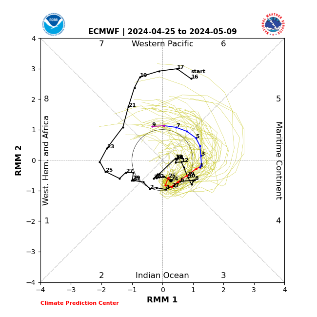
Now it says Phase 1 two days ago it was saying 8 and two before 7
_________________
Mugs
AKA:King: Snow Weenie
Self Proclaimed
WINTER 2014-15 : 55.12" +.02 for 6 coatings (avg. 35")
WINTER 2015-16 Total - 29.8" (Avg 35")
WINTER 2016-17 : 39.5" so far
amugs- Advanced Forecaster - Mod
- Posts : 15095
Reputation : 213
Join date : 2013-01-07
Age : 54
Location : Hillsdale,NJ
Re: Long Range Thread 27.0
![]() by Irish Fri Dec 15, 2023 8:19 am
by Irish Fri Dec 15, 2023 8:19 am
amugs wrote:MJO teles - can this ever chnage more than it has the last 7 days??
Now it says Phase 1 two days ago it was saying 8 and two before 7
I've learned that really, no one knows what they're doing!
We're all going into this, like walking into a blizzard, blind. 🤪
Irish- Pro Enthusiast
- Posts : 788
Reputation : 19
Join date : 2019-01-16
Age : 45
Location : Old Bridge, NJ
heehaw453 likes this post
Re: Long Range Thread 27.0
![]() by sroc4 Fri Dec 15, 2023 8:40 am
by sroc4 Fri Dec 15, 2023 8:40 am
Irish wrote:amugs wrote:MJO teles - can this ever chnage more than it has the last 7 days??
Now it says Phase 1 two days ago it was saying 8 and two before 7
I've learned that really, no one knows what they're doing!
We're all going into this, like walking into a blizzard, blind. 🤪
Given the past few years the appropriate analogy may be more like: driving in a torrential down pour with shitty wipers.
_________________
"In weather and in life, there's no winning and losing; there's only winning and learning."
WINTER 2012/2013 TOTALS 43.65"WINTER 2017/2018 TOTALS 62.85" WINTER 2022/2023 TOTALS 4.9"
WINTER 2013/2014 TOTALS 64.85"WINTER 2018/2019 TOTALS 14.25" WINTER 2023/2024 TOTALS 13.1"
WINTER 2014/2015 TOTALS 71.20"WINTER 2019/2020 TOTALS 6.35"
WINTER 2015/2016 TOTALS 35.00"WINTER 2020/2021 TOTALS 37.75"
WINTER 2016/2017 TOTALS 42.25"WINTER 2021/2022 TOTALS 31.65"
sroc4- Admin
- Posts : 8394
Reputation : 302
Join date : 2013-01-07
Location : Wading River, LI
amugs, Sparky Sparticles, SENJsnowman and Irish like this post
Re: Long Range Thread 27.0
![]() by heehaw453 Fri Dec 15, 2023 8:40 am
by heehaw453 Fri Dec 15, 2023 8:40 am
amugs wrote:MJO teles - can this ever chnage more than it has the last 7 days??
Now it says Phase 1 two days ago it was saying 8 and two before 7
IMO MJO propagation and amplitude is one of the most difficult and frustrating things to try and predict. Personally I'd rather just see it muted and get out of the way.
heehaw453- Advanced Forecaster
- Posts : 3906
Reputation : 86
Join date : 2014-01-20
Location : Bedminster Township, PA Elevation 600' ASL
Re: Long Range Thread 27.0
![]() by heehaw453 Fri Dec 15, 2023 8:50 am
by heehaw453 Fri Dec 15, 2023 8:50 am

heehaw453- Advanced Forecaster
- Posts : 3906
Reputation : 86
Join date : 2014-01-20
Location : Bedminster Township, PA Elevation 600' ASL
Re: Long Range Thread 27.0
![]() by Irish Fri Dec 15, 2023 9:01 am
by Irish Fri Dec 15, 2023 9:01 am
sroc4 wrote:Irish wrote:amugs wrote:MJO teles - can this ever chnage more than it has the last 7 days??
Now it says Phase 1 two days ago it was saying 8 and two before 7
I've learned that really, no one knows what they're doing!
We're all going into this, like walking into a blizzard, blind. 🤪
Given the past few years the appropriate analogy may be more like: driving in a torrential down pour with shitty wipers.
That's hysterical! And so true!
Irish- Pro Enthusiast
- Posts : 788
Reputation : 19
Join date : 2019-01-16
Age : 45
Location : Old Bridge, NJ
Page 13 of 40 • 1 ... 8 ... 12, 13, 14 ... 26 ... 40 ![]()
|
|
|