
 Search
Long Range Thread 27.0
Page 16 of 40 •  1 ... 9 ... 15, 16, 17 ... 28 ... 40
 ![]()
Re: Long Range Thread 27.0
![]() by sroc4 Mon Dec 18, 2023 9:34 am
by sroc4 Mon Dec 18, 2023 9:34 am
rb924119 wrote:sroc4 wrote:Frank_Wx wrote:
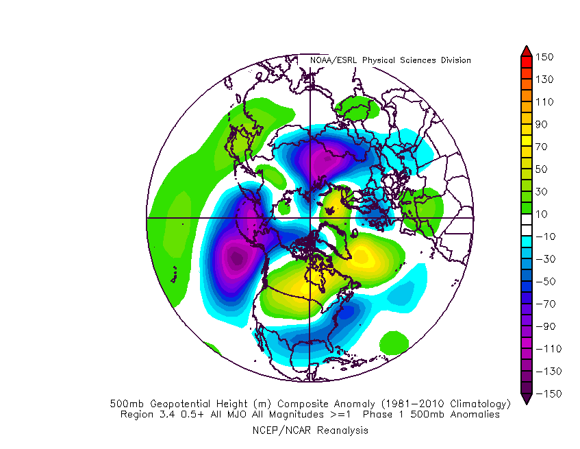
The MJO forecast suggests we will be entering predominately phase 1 later this month. Above is the upper level pattern combination for el nino and phase 1. This would definitely work, but I would have concerns about the cold air source again. However the psuedo blocking in the Atlantic combined with the active stj could definitely bring about snowfall. Just not sure how much northern stream interaction we would see as this shows verbatim.
Verbatim that look has the dreaded strong Pacific jet
Love ya, buddy, but

lol


You can angry emoji me all you want my good sir but this does not change what I said. Obv that image is a composite of multiple years combined. Its a mean of multiple looks.
And while it does not show a strong ridge in the SE CONUS, it does show a strong Pac jet. This is not a classic -EPO ridge over a south of Aleutian's trough; rather, it shows a +EPO with a strong Pac Jet as a part of that mean look that at times reaches the west coast, which dampens a PNA ridge at times. Combine that with an active STJ that unless the timing of some of the other pieces is right, you get over amplified southern stream systems that can raise heights out ahead; esp if the Pac jet ext reaches the west coast. And while it may be workable, a ridge over the Hudson Bay is less than ideal. With a ridge in that general region and a +EPO there is not much of a cold push, unless things line up. And this image also has the "pseudo" -NAO look. This is not a traditional -NAO. And while this too can be workable, it is less than ideal unless you have cooperation with timing and positioning of the other factors back west.

Now to be fair, this is truly a workable scenario. This isnt a foregone conclusion in either direction. It has snowed all the way to the coast in way worse set ups, but the idea that the Pac jet isn't a part of the means in this composite?? I dont think you can say that.
sroc4- Admin

- Posts : 8445
Join date : 2013-01-07
Re: Long Range Thread 27.0
![]() by sroc4 Mon Dec 18, 2023 9:40 am
by sroc4 Mon Dec 18, 2023 9:40 am
sroc4- Admin
- Posts : 8445
Join date : 2013-01-07
docstox12, CPcantmeasuresnow and kalleg like this post
Re: Long Range Thread 27.0
![]() by HectorO Mon Dec 18, 2023 10:17 am
by HectorO Mon Dec 18, 2023 10:17 am
sroc4 wrote:For the record I do think there is a period of legit cold enough and snow beginning after Xmas through new years and likely for a week to 10days into Jan. Then...we may get a Jan thaw. After that do we reload into the cold and snow for the end of Jan and Feb? Well I want to believe that based on the Strat info coming in, but its too far off.
A thaw to our already thawed, green, flooded surface.

HectorO- Pro Enthusiast

- Posts : 975
Reputation : 27
Join date : 2013-01-11
Irish likes this post


dkodgis- Senior Enthusiast

- Posts : 2669
Reputation : 98
Join date : 2013-12-29
Re: Long Range Thread 27.0
![]() by Koroptim Mon Dec 18, 2023 10:52 am
by Koroptim Mon Dec 18, 2023 10:52 am
Koroptim- Posts : 29
Reputation : 0
Join date : 2013-01-16
Re: Long Range Thread 27.0
![]() by sroc4 Mon Dec 18, 2023 10:56 am
by sroc4 Mon Dec 18, 2023 10:56 am
HectorO wrote:sroc4 wrote:For the record I do think there is a period of legit cold enough and snow beginning after Xmas through new years and likely for a week to 10days into Jan. Then...we may get a Jan thaw. After that do we reload into the cold and snow for the end of Jan and Feb? Well I want to believe that based on the Strat info coming in, but its too far off.
A thaw to our already thawed, green, flooded surface.

_________________
"In weather and in life, there's no winning and losing; there's only winning and learning."
WINTER 2012/2013 TOTALS 43.65"WINTER 2017/2018 TOTALS 62.85" WINTER 2022/2023 TOTALS 4.9"
WINTER 2013/2014 TOTALS 64.85"WINTER 2018/2019 TOTALS 14.25" WINTER 2023/2024 TOTALS 13.1"
WINTER 2014/2015 TOTALS 71.20"WINTER 2019/2020 TOTALS 6.35"
WINTER 2015/2016 TOTALS 35.00"WINTER 2020/2021 TOTALS 37.75"
WINTER 2016/2017 TOTALS 42.25"WINTER 2021/2022 TOTALS 31.65"

sroc4- Admin
- Posts : 8445
Reputation : 302
Join date : 2013-01-07
Location : Wading River, LI
HectorO and dkodgis like this post
Re: Long Range Thread 27.0
![]() by heehaw453 Mon Dec 18, 2023 11:46 am
by heehaw453 Mon Dec 18, 2023 11:46 am


heehaw453- Advanced Forecaster

- Posts : 3910
Reputation : 86
Join date : 2014-01-20
Location : Bedminster Township, PA Elevation 600' ASL
dkodgis likes this post
Re: Long Range Thread 27.0
![]() by Frank_Wx Mon Dec 18, 2023 12:17 pm
by Frank_Wx Mon Dec 18, 2023 12:17 pm
December 22nd
*In the words of my nonna, "fa schifo" which translates to "that is gross." I attempted to outline the pacific jet extension which has already been discussed here a couple of pages back. The country is flooded with mild air and there's nothing exciting to really talk about. However, pay attention to the areas I circled in green. One being the central canadian ridge. The other being the alaskan trough, also known as a +EPO.
December 26th
*Nonna is still not happy with this look but, if you play this on a loop, there's some optimism beginning to spread. The central canadian ridge I initially outlined is now "back building" in the west-northwest side of Canada. Also, the deepest blue (negative) anomalies of the alaskan trough began shifting more north-northwest. Both of these features are beginning their retrograde, which tells me the models are adjusting to an El Nino base state atmospheric upper level pattern. Some of this is being triggered by the MJO too, but I think El Nino is your driving factor here.
January 1st
*This is now a full-fledge El Nino looks. The trough over the south-southeast CONUS represents your "wet and cool" that you typically see on El Nino maps posted by the NWS. The upper midwest / PAC NW is under drier and milder conditions thanks to your +PNA/-EPO couplet. It's VERY nice to see a ridge over Alaska. That ridge I showed in my previous image has retrograded back far enough NW, that is allows the polar jet stream to sink into our part of the country. This combination of polar air and sub-tropical activity is exactly what we need to get colder and snowier conditions. The EPS has model support from the GEFS. And what I'm seeing play out in the Pacific with regards to El Nino, MJO, etc. makes me feel pretty good about this.
So, all this to say that we need to give this 3-4 more days and hope we continue to see consistency in the modeling. If we begin to see them waver, or keep pushing the timeline back, I would get a little worried that the only way to turn this pattern around is through the Stratosphere. Which may still happen regardless.
- Attachments

- 22nd.png You don't have permission to download attachments.(1.1 Mb) Downloaded 10 times
- 26th.png You don't have permission to download attachments.(1 Mb) Downloaded 6 times
- 1st.png You don't have permission to download attachments.(879 Kb) Downloaded 7 times
_________________
_______________________________________________________________________________________________________
CLICK HERE to view NJ Strong Snowstorm Classifications

Frank_Wx- Godzilla Seeker
- Posts : 21311
Reputation : 328
Join date : 2013-01-05
Age : 32
Location : Jersey City, NJ -

sroc4, kalleg, heehaw453, SENJsnowman and phil155 like this post
Re: Long Range Thread 27.0
![]() by frank 638 Mon Dec 18, 2023 12:32 pm
by frank 638 Mon Dec 18, 2023 12:32 pm
frank 638- Senior Enthusiast
- Posts : 2872
Reputation : 37
Join date : 2016-01-01
Age : 41
Location : bronx ny
Re: Long Range Thread 27.0
![]() by sroc4 Mon Dec 18, 2023 12:34 pm
by sroc4 Mon Dec 18, 2023 12:34 pm
frank 638 wrote:What are you guys think of AccuWeather ? In the long range they show colder and a couple snow chances for the month of January.
They see what we see.
_________________
"In weather and in life, there's no winning and losing; there's only winning and learning."
WINTER 2012/2013 TOTALS 43.65"WINTER 2017/2018 TOTALS 62.85" WINTER 2022/2023 TOTALS 4.9"
WINTER 2013/2014 TOTALS 64.85"WINTER 2018/2019 TOTALS 14.25" WINTER 2023/2024 TOTALS 13.1"
WINTER 2014/2015 TOTALS 71.20"WINTER 2019/2020 TOTALS 6.35"
WINTER 2015/2016 TOTALS 35.00"WINTER 2020/2021 TOTALS 37.75"
WINTER 2016/2017 TOTALS 42.25"WINTER 2021/2022 TOTALS 31.65"
sroc4- Admin
- Posts : 8445
Reputation : 302
Join date : 2013-01-07
Location : Wading River, LI
Re: Long Range Thread 27.0
![]() by rb924119 Mon Dec 18, 2023 2:39 pm
by rb924119 Mon Dec 18, 2023 2:39 pm
sroc4 wrote:rb924119 wrote:sroc4 wrote:Frank_Wx wrote:
The MJO forecast suggests we will be entering predominately phase 1 later this month. Above is the upper level pattern combination for el nino and phase 1. This would definitely work, but I would have concerns about the cold air source again. However the psuedo blocking in the Atlantic combined with the active stj could definitely bring about snowfall. Just not sure how much northern stream interaction we would see as this shows verbatim.
Verbatim that look has the dreaded strong Pacific jet
Love ya, buddy, but
You can angry emoji me all you want my good sir but this does not change what I said. Obv that image is a composite of multiple years combined. Its a mean of multiple looks.
And while it does not show a strong ridge in the SE CONUS, it does show a strong Pac jet. This is not a classic -EPO ridge over a south of Aleutian's trough; rather, it shows a +EPO with a strong Pac Jet as a part of that mean look that at times reaches the west coast, which dampens a PNA ridge at times. Combine that with an active STJ that unless the timing of some of the other pieces is right, you get over amplified southern stream systems that can raise heights out ahead; esp if the Pac jet ext reaches the west coast. And while it may be workable, a ridge over the Hudson Bay is less than ideal. With a ridge in that general region and a +EPO there is not much of a cold push, unless things line up. And this image also has the "pseudo" -NAO look. This is not a traditional -NAO. And while this too can be workable, it is less than ideal unless you have cooperation with timing and positioning of the other factors back west.
Now to be fair, this is truly a workable scenario. This isnt a foregone conclusion in either direction. It has snowed all the way to the coast in way worse set ups, but the idea that the Pac jet isn't a part of the means in this composite?? I dont think you can say that.
I never said that the Pacific jet doesn’t come into play, my man. But when you’re dealing with blocking, what happens? The jet cuts underneath the blocking ridge in the higher latitudes. In EVERY case. Take a -NAO, for example. Why do we like it so much? Because it forces the jet/storm track further south across the central Atlantic. In a +NAO, it fights to lift northward over the eastern U.S. unless there are other factors in play. When there’s blocking across Canada, what happens? Instead of allowing cutters, you end up with storms that make it to about our latitude and then are forced to transfer to the coast because they can’t fight through the block. When you have your -EPO, where’s the jet? It’s further south across the central Pacific. And, in most cases when there’s a +PNA, you have one of two things occur; either energy fights through the PNA ridge and amplifies downstream, or, it gets suppressed far enough so that it ends up in the sub-tropical jet. Look at the maps of a lot of your “great” winters and individual storms, and A LOT of them have a similar look.
I’ll end with this, because honestly, there’s no sense continuing to flog this dead horse. As long as you keep seeing that Hudson Bay block show up and be the dominant ridge, the models will respond accordingly with a colder overall look and more southerly storm track. It may take them time to “see” it, that’s why we forecast
rb924119- Meteorologist

- Posts : 7033
Reputation : 195
Join date : 2013-02-06
Age : 32
Location : Greentown, Pa
amugs likes this post
Re: Long Range Thread 27.0
![]() by heehaw453 Mon Dec 18, 2023 4:55 pm
by heehaw453 Mon Dec 18, 2023 4:55 pm


heehaw453- Advanced Forecaster
- Posts : 3910
Reputation : 86
Join date : 2014-01-20
Location : Bedminster Township, PA Elevation 600' ASL
sroc4 likes this post
Re: Long Range Thread 27.0
![]() by Frank_Wx Mon Dec 18, 2023 6:06 pm
by Frank_Wx Mon Dec 18, 2023 6:06 pm
_________________
_______________________________________________________________________________________________________
CLICK HERE to view NJ Strong Snowstorm Classifications
Frank_Wx- Godzilla Seeker
- Posts : 21311
Reputation : 328
Join date : 2013-01-05
Age : 32
Location : Jersey City, NJ -
Re: Long Range Thread 27.0
![]() by sroc4 Mon Dec 18, 2023 6:14 pm
by sroc4 Mon Dec 18, 2023 6:14 pm
heehaw453 wrote:Got to give some props to Rb and Sroc. The MJO seems to be coming into phase 8. I think it was sroc who called out 12/20 ish for better things to come.
One thing I will say though is that those temp composites is that they dont always correlate with El Nino years. This is what a phase 8 500mb mean pattern looks like in December when ENSO 3.4 is above 0.5 It actually alot like what the mean pattern is shaping up like over the next 3-4 days which jives with the MJO forecast above with ridging across NA.
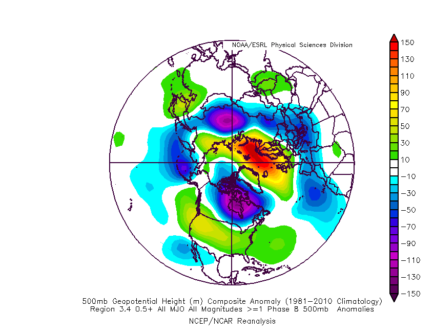


Then by Xmas eve and beyond into phase 1. Here is the Mean 550mb look during El Nino events during Dec phase 1, and what the mean pattern loosk like after Xmas eve. Looks very similar for sure.


_________________
"In weather and in life, there's no winning and losing; there's only winning and learning."
WINTER 2012/2013 TOTALS 43.65"WINTER 2017/2018 TOTALS 62.85" WINTER 2022/2023 TOTALS 4.9"
WINTER 2013/2014 TOTALS 64.85"WINTER 2018/2019 TOTALS 14.25" WINTER 2023/2024 TOTALS 13.1"
WINTER 2014/2015 TOTALS 71.20"WINTER 2019/2020 TOTALS 6.35"
WINTER 2015/2016 TOTALS 35.00"WINTER 2020/2021 TOTALS 37.75"
WINTER 2016/2017 TOTALS 42.25"WINTER 2021/2022 TOTALS 31.65"
sroc4- Admin
- Posts : 8445
Reputation : 302
Join date : 2013-01-07
Location : Wading River, LI
heehaw453 likes this post
Re: Long Range Thread 27.0
![]() by sroc4 Mon Dec 18, 2023 6:16 pm
by sroc4 Mon Dec 18, 2023 6:16 pm
Frank_Wx wrote:https://x.com/jhomenuk/status/1736848763673542913?s=46&t=khIuo-joMGhpKcLk0g9Y4g
So hes punting the time frame between now and the second half of Jan. Sweet.
_________________
"In weather and in life, there's no winning and losing; there's only winning and learning."
WINTER 2012/2013 TOTALS 43.65"WINTER 2017/2018 TOTALS 62.85" WINTER 2022/2023 TOTALS 4.9"
WINTER 2013/2014 TOTALS 64.85"WINTER 2018/2019 TOTALS 14.25" WINTER 2023/2024 TOTALS 13.1"
WINTER 2014/2015 TOTALS 71.20"WINTER 2019/2020 TOTALS 6.35"
WINTER 2015/2016 TOTALS 35.00"WINTER 2020/2021 TOTALS 37.75"
WINTER 2016/2017 TOTALS 42.25"WINTER 2021/2022 TOTALS 31.65"
sroc4- Admin
- Posts : 8445
Reputation : 302
Join date : 2013-01-07
Location : Wading River, LI
Re: Long Range Thread 27.0
![]() by heehaw453 Mon Dec 18, 2023 6:26 pm
by heehaw453 Mon Dec 18, 2023 6:26 pm
sroc4 wrote:Frank_Wx wrote:https://x.com/jhomenuk/status/1736848763673542913?s=46&t=khIuo-joMGhpKcLk0g9Y4g
So hes punting the time frame between now and the second half of Jan. Sweet.
I guess he's thinking cold air needs to be more deeply penetrated? Not sure, but cold enough is a matter of a strong H oozing down from CA and the AO going more neutral/negative with a +PNA can certainly help facilitate that before mid January.
heehaw453- Advanced Forecaster
- Posts : 3910
Reputation : 86
Join date : 2014-01-20
Location : Bedminster Township, PA Elevation 600' ASL
Re: Long Range Thread 27.0
![]() by Frank_Wx Mon Dec 18, 2023 6:37 pm
by Frank_Wx Mon Dec 18, 2023 6:37 pm
sroc4 wrote:Frank_Wx wrote:https://x.com/jhomenuk/status/1736848763673542913?s=46&t=khIuo-joMGhpKcLk0g9Y4g
So hes punting the time frame between now and the second half of Jan. Sweet.
The airmass isn’t ready before then, IMO. Maybe we squeeze out a minor event near the 30th
_________________
_______________________________________________________________________________________________________
CLICK HERE to view NJ Strong Snowstorm Classifications
Frank_Wx- Godzilla Seeker
- Posts : 21311
Reputation : 328
Join date : 2013-01-05
Age : 32
Location : Jersey City, NJ -
Re: Long Range Thread 27.0
![]() by tomsriversnowstorm Mon Dec 18, 2023 7:42 pm
by tomsriversnowstorm Mon Dec 18, 2023 7:42 pm
sroc4 wrote:Frank_Wx wrote:https://x.com/jhomenuk/status/1736848763673542913?s=46&t=khIuo-joMGhpKcLk0g9Y4g
So hes punting the time frame between now and the second half of Jan. Sweet.
tomsriversnowstorm- Posts : 101
Reputation : 0
Join date : 2021-02-06
Re: Long Range Thread 27.0
![]() by sroc4 Mon Dec 18, 2023 11:34 pm
by sroc4 Mon Dec 18, 2023 11:34 pm
tomsriversnowstorm wrote:There are other experts such as RB and Sroc who say the opposite. In my opinion both have more knowledge and are less arrogant. I am excited about what are RB was saying.sroc4 wrote:Frank_Wx wrote:https://x.com/jhomenuk/status/1736848763673542913?s=46&t=khIuo-joMGhpKcLk0g9Y4g
So hes punting the time frame between now and the second half of Jan. Sweet.
Me and Rb are not quite on the same page with everything upcoming although we do agree on several ideas. And I am anything but an expert. I’m just a winter weather weenie like everyone else.
_________________
"In weather and in life, there's no winning and losing; there's only winning and learning."
WINTER 2012/2013 TOTALS 43.65"WINTER 2017/2018 TOTALS 62.85" WINTER 2022/2023 TOTALS 4.9"
WINTER 2013/2014 TOTALS 64.85"WINTER 2018/2019 TOTALS 14.25" WINTER 2023/2024 TOTALS 13.1"
WINTER 2014/2015 TOTALS 71.20"WINTER 2019/2020 TOTALS 6.35"
WINTER 2015/2016 TOTALS 35.00"WINTER 2020/2021 TOTALS 37.75"
WINTER 2016/2017 TOTALS 42.25"WINTER 2021/2022 TOTALS 31.65"
sroc4- Admin
- Posts : 8445
Reputation : 302
Join date : 2013-01-07
Location : Wading River, LI
Re: Long Range Thread 27.0
![]() by amugs Mon Dec 18, 2023 11:36 pm
by amugs Mon Dec 18, 2023 11:36 pm
Let's hope this all comes to fruitin....MJO, Telescope, Maps!!


_________________
Mugs
AKA:King: Snow Weenie
Self Proclaimed
WINTER 2014-15 : 55.12" +.02 for 6 coatings (avg. 35")
WINTER 2015-16 Total - 29.8" (Avg 35")
WINTER 2016-17 : 39.5" so far

amugs- Advanced Forecaster - Mod

- Posts : 15130
Reputation : 213
Join date : 2013-01-07
Age : 54
Location : Hillsdale,NJ
sroc4 likes this post
Re: Long Range Thread 27.0
![]() by amugs Mon Dec 18, 2023 11:46 pm
by amugs Mon Dec 18, 2023 11:46 pm


_________________
Mugs
AKA:King: Snow Weenie
Self Proclaimed
WINTER 2014-15 : 55.12" +.02 for 6 coatings (avg. 35")
WINTER 2015-16 Total - 29.8" (Avg 35")
WINTER 2016-17 : 39.5" so far
amugs- Advanced Forecaster - Mod
- Posts : 15130
Reputation : 213
Join date : 2013-01-07
Age : 54
Location : Hillsdale,NJ
sroc4 likes this post
Re: Long Range Thread 27.0
![]() by tomsriversnowstorm Mon Dec 18, 2023 11:59 pm
by tomsriversnowstorm Mon Dec 18, 2023 11:59 pm
sroc4 wrote:tomsriversnowstorm wrote:There are other experts such as RB and Sroc who say the opposite. In my opinion both have more knowledge and are less arrogant. I am excited about what are RB was saying.sroc4 wrote:Frank_Wx wrote:https://x.com/jhomenuk/status/1736848763673542913?s=46&t=khIuo-joMGhpKcLk0g9Y4g
So hes punting the time frame between now and the second half of Jan. Sweet.
Me and Rb are not quite on the same page with everything upcoming although we do agree on several ideas. And I am anything but an expert. I’m just a winter weather weenie like everyone else.
tomsriversnowstorm- Posts : 101
Reputation : 0
Join date : 2021-02-06
sroc4 and SENJsnowman like this post
Re: Long Range Thread 27.0
![]() by heehaw453 Tue Dec 19, 2023 10:53 am
by heehaw453 Tue Dec 19, 2023 10:53 am

heehaw453- Advanced Forecaster
- Posts : 3910
Reputation : 86
Join date : 2014-01-20
Location : Bedminster Township, PA Elevation 600' ASL
sroc4, kalleg and SENJsnowman like this post
Re: Long Range Thread 27.0
![]() by sroc4 Tue Dec 19, 2023 11:00 am
by sroc4 Tue Dec 19, 2023 11:00 am
heehaw453 wrote:I'd be surprised if at least the interior doesn't get some snowfall before we close out December say from 27-31. This kind of split flow look has cold air oozing down and weak s/w pushing off the coast. It won't take much for a few inches in this setup. Coastal plain boundary layer issues but even there a strong banana H could do it with just a weak s/w.
I honestly couldn't agree more. Both modeling and observation has me excited actually. Longer write up coming today or tomorrow hopefully.
_________________
"In weather and in life, there's no winning and losing; there's only winning and learning."
WINTER 2012/2013 TOTALS 43.65"WINTER 2017/2018 TOTALS 62.85" WINTER 2022/2023 TOTALS 4.9"
WINTER 2013/2014 TOTALS 64.85"WINTER 2018/2019 TOTALS 14.25" WINTER 2023/2024 TOTALS 13.1"
WINTER 2014/2015 TOTALS 71.20"WINTER 2019/2020 TOTALS 6.35"
WINTER 2015/2016 TOTALS 35.00"WINTER 2020/2021 TOTALS 37.75"
WINTER 2016/2017 TOTALS 42.25"WINTER 2021/2022 TOTALS 31.65"
sroc4- Admin
- Posts : 8445
Reputation : 302
Join date : 2013-01-07
Location : Wading River, LI
docstox12, heehaw453, SENJsnowman and MattyICE like this post
Re: Long Range Thread 27.0
![]() by crippo84 Tue Dec 19, 2023 2:46 pm
by crippo84 Tue Dec 19, 2023 2:46 pm
sroc4 wrote:heehaw453 wrote:I'd be surprised if at least the interior doesn't get some snowfall before we close out December say from 27-31. This kind of split flow look has cold air oozing down and weak s/w pushing off the coast. It won't take much for a few inches in this setup. Coastal plain boundary layer issues but even there a strong banana H could do it with just a weak s/w.
I honestly couldn't agree more. Both modeling and observation has me excited actually. Longer write up coming today or tomorrow hopefully.
I sense a "We Track
 " incoming. Can't wait.
crippo84- Posts : 383
Reputation : 20
Join date : 2013-11-07
Age : 40
Location : East Village, NYC
docstox12 and dkodgis like this post
Re: Long Range Thread 27.0
![]() by SENJsnowman Tue Dec 19, 2023 2:57 pm
by SENJsnowman Tue Dec 19, 2023 2:57 pm
crippo84 wrote:sroc4 wrote:heehaw453 wrote:I'd be surprised if at least the interior doesn't get some snowfall before we close out December say from 27-31. This kind of split flow look has cold air oozing down and weak s/w pushing off the coast. It won't take much for a few inches in this setup. Coastal plain boundary layer issues but even there a strong banana H could do it with just a weak s/w.
I honestly couldn't agree more. Both modeling and observation has me excited actually. Longer write up coming today or tomorrow hopefully.
I sense a "We Track
Could not agree more, Crippo. And I hope you are right! It looks tracking season has begun, and for me…
“It’s the most wonderful time of the year!!”
SENJsnowman- Senior Enthusiast
- Posts : 1197
Reputation : 61
Join date : 2017-01-06
Age : 51
Location : Long Branch, NJ
docstox12 and heehaw453 like this post
Re: Long Range Thread 27.0
![]() by Frank_Wx Tue Dec 19, 2023 5:17 pm
by Frank_Wx Tue Dec 19, 2023 5:17 pm
heehaw453 wrote:I'd be surprised if at least the interior doesn't get some snowfall before we close out December say from 27-31. This kind of split flow look has cold air oozing down and weak s/w pushing off the coast. It won't take much for a few inches in this setup. Coastal plain boundary layer issues but even there a strong banana H could do it with just a weak s/w.
Agreed about interior. Coast is going to struggle, but, never know.
Taking a look at things again this afternoon, I feel good about the post I made yesterday with regards to JAN. Once we get to the 1st, we should have the right alignment at 500mb to move us in the right direction as it pertains to colder and stormier than normal weather. The 12z GEFS continue to push the idea of ridging over the EPO domain and a very active sub tropical jet streak along the south-southeastern U.S. Our area is squeezed in between both of these features. Call it the "battle zone" if you will. This zone is going to experience frequent storm activity with temperatures near the freezing mark. The way to stay on the cold side of these storms is all dependent on the storm track, which is dependent on other things like Atlantic blocking, 50/50 low, etc. But no sense in going into details on that yet. First, we need a storm!!!
_________________
_______________________________________________________________________________________________________
CLICK HERE to view NJ Strong Snowstorm Classifications
Frank_Wx- Godzilla Seeker
- Posts : 21311
Reputation : 328
Join date : 2013-01-05
Age : 32
Location : Jersey City, NJ -
docstox12, kalleg and heehaw453 like this post
Page 16 of 40 • 1 ... 9 ... 15, 16, 17 ... 28 ... 40 ![]()