
 Search
Long Range Thread 27.0
Page 30 of 40 •  1 ... 16 ... 29, 30, 31 ... 35 ... 40
 ![]()

amugs- Advanced Forecaster - Mod

- Posts : 15130
Join date : 2013-01-07
Re: Long Range Thread 27.0
![]() by docstox12 Sun Jan 07, 2024 8:43 am
by docstox12 Sun Jan 07, 2024 8:43 am
We need a lot colder air and a better storm track.
docstox12- Wx Statistician Guru

- Posts : 8597
Join date : 2013-01-07
weatherwatchermom likes this post
Re: Long Range Thread 27.0
![]() by Irish Sun Jan 07, 2024 9:10 am
by Irish Sun Jan 07, 2024 9:10 am
docstox12 wrote:Looks like the rainy and mild pattern in effect since Nov.1 returns this week with two rainstorms on tap.Actually , a lot of the Forum had rain with the storm last night.
We need a lot colder air and a better storm track.
Yup, just saw that as well. 2 rain storms - Tuesday and then Friday into Saturday. Then it gets cold. We'll see if anything can happen during that period or if it'll be just dry and cold...

Irish- Pro Enthusiast

- Posts : 788
Reputation : 19
Join date : 2019-01-16
Age : 46
Location : Old Bridge, NJ
weatherwatchermom likes this post
Re: Long Range Thread 27.0
![]() by heehaw453 Sun Jan 07, 2024 9:28 am
by heehaw453 Sun Jan 07, 2024 9:28 am
And I'm not saying there cannot be any frozen with this, but just not anything sig for the I95 and immediate area with that setup. So until that PNA relaxes I think snow chances wait.

heehaw453- Advanced Forecaster

- Posts : 3913
Reputation : 86
Join date : 2014-01-20
Location : Bedminster Township, PA Elevation 600' ASL
Re: Long Range Thread 27.0
![]() by CPcantmeasuresnow Sun Jan 07, 2024 10:40 am
by CPcantmeasuresnow Sun Jan 07, 2024 10:40 am
docstox12 wrote:Looks like the rainy and mild pattern in effect since Nov.1 returns this week with two rainstorms on tap.Actually , a lot of the Forum had rain with the storm last night.
We need a lot colder air and a better storm track.
Inside the bench mark is our track Doc, I realize it doesn't help the coasties but east of benchmark is best for them and that usually keeps us out of the heaviest stuff.
WTS the next two storms will suck for everyone forum wide.

CPcantmeasuresnow- Wx Statistician Guru
- Posts : 7274
Reputation : 230
Join date : 2013-01-07
Age : 103
Location : Eastern Orange County, NY
Re: Long Range Thread 27.0
![]() by docstox12 Sun Jan 07, 2024 10:52 am
by docstox12 Sun Jan 07, 2024 10:52 am
CPcantmeasuresnow wrote:docstox12 wrote:Looks like the rainy and mild pattern in effect since Nov.1 returns this week with two rainstorms on tap.Actually , a lot of the Forum had rain with the storm last night.
We need a lot colder air and a better storm track.
Inside the bench mark is our track Doc, I realize it doesn't help the coasties but east of benchmark is best for them and that usually keeps us out of the heaviest stuff.
WTS the next two storms will suck for everyone forum wide.
Right CP, Hudson Valley inside the BM special it was.
Hate to see our area after this deluge and warm up Tues and Weds.

docstox12- Wx Statistician Guru
- Posts : 8597
Reputation : 222
Join date : 2013-01-07
Age : 73
Location : Monroe NY
Re: Long Range Thread 27.0
![]() by heehaw453 Sun Jan 07, 2024 11:35 am
by heehaw453 Sun Jan 07, 2024 11:35 am
Let's get this look consistent for a few days and then tracking will be in full force IMO.


heehaw453- Advanced Forecaster
- Posts : 3913
Reputation : 86
Join date : 2014-01-20
Location : Bedminster Township, PA Elevation 600' ASL
CPcantmeasuresnow, kalleg and billg315 like this post
Re: Long Range Thread 27.0
![]() by heehaw453 Sun Jan 07, 2024 2:12 pm
by heehaw453 Sun Jan 07, 2024 2:12 pm

heehaw453- Advanced Forecaster
- Posts : 3913
Reputation : 86
Join date : 2014-01-20
Location : Bedminster Township, PA Elevation 600' ASL
amugs, kalleg, rb924119 and jmanley32 like this post
Re: Long Range Thread 27.0
![]() by rb924119 Sun Jan 07, 2024 5:22 pm
by rb924119 Sun Jan 07, 2024 5:22 pm
Hopefully you guys followed that lol as I said, it’s something that requires more thought, but that’s kind of where my head is at for the closing days of January and into a lot of February. We’ll see. If it does play out that way, though, I think we’d be in for one heck of a March and front half of April……and I mean 2018 style lol because then you’d have the MJO-induced Strat-warm constructively interfering with the ENSO state and MJO, plus the apparent tendency for true Atlantic domain blocking initiation and maintenance.
Last edited by rb924119 on Sun Jan 07, 2024 5:27 pm; edited 1 time in total
rb924119- Meteorologist

- Posts : 7037
Reputation : 195
Join date : 2013-02-06
Age : 32
Location : Greentown, Pa
Re: Long Range Thread 27.0
![]() by jmanley32 Sun Jan 07, 2024 5:26 pm
by jmanley32 Sun Jan 07, 2024 5:26 pm

jmanley32- Senior Enthusiast

- Posts : 20638
Reputation : 108
Join date : 2013-12-12
Age : 43
Location : Yonkers, NY
kalleg likes this post

Lnda23- Posts : 30
Reputation : 3
Join date : 2013-01-08
Location : Garwood, NJ
Re: Long Range Thread 27.0
![]() by nutleyblizzard Sun Jan 07, 2024 6:14 pm
by nutleyblizzard Sun Jan 07, 2024 6:14 pm
Enjoy the next 2-3 weeks? In the next 10 days we’re looking at two cutters. After that I don’t trust the models since they’ve been acting bipolar lately. Now your throwing hints that February might go in the crapper as well? It would no longer surprise me if Central Park gets shut out this winter.rb924119 wrote:We should enjoy these next two to three weeks, because I’m not sure how February is going to turn out, though I fear it won’t be too pretty. We might have to wait for another MJO-induced Strat-warm event to salvage March, because it looks to me like the MJO is gonna have some serious amplitude and staying power in unfavorable phases (4, 5, and 6). Where I’m uncertain, though, is how this is going to play with the central-based El Niño, which is a good ENSO situation to be in. What could end up happening, is you get what I’ll term as “home grown blocking”, where you get a highly amplified long wave pattern where a big ridge balloons over the eastern CONUS, but then is forced to cyclonically wave break in response to an amplifying storm coming out of the West. When that happens, yeah, you’ll get a cutter, but then with the ridge now draping across southern Canada, it could act like the late stages of a NAO block that comes back. So, following the cutter, you have all kinds of high pressure over Canada oozing cool air down, and with the tendency for the Pacific to dump troughs into the West when the MJO is in those unfavorable phases, it seeds the southern stream with a continuous supply of shortwaves that cut beneath the ridge. Granted, the air oozing southward from Canada wouldn’t be cold, but in peak climo and a suppressed storm track it could work. Then what would likely happen is that that “home grown block” would sync back up with a mid-latitude ridge that spikes east of the Rockies in response to a deepening shortwave in the West, and you could get a storm from energy that drops down the eastern flank of that ridge, amplifies, and then comes up with a better air source. After that, the pattern would progress, the ridge would come back to the East, and then it would rinse, wash, repeat until the MJO gets back in better phases and in sync with the auspicious ENSO support.
Hopefully you guys followed that lol as I said, it’s something that requires more thought, but that’s kind of where my head is at for the closing days of January and into a lot of February. We’ll see. If it does play out that way, though, I think we’d be in for one heck of a March and front half of April……and I mean 2018 style lol because then you’d have the MJO-induced Strat-warm constructively interfering with the ENSO state and MJO, plus the apparent tendency for true Atlantic domain blocking initiation and maintenance.

nutleyblizzard- Senior Enthusiast
- Posts : 1963
Reputation : 41
Join date : 2014-01-30
Age : 58
Location : Nutley, new jersey
jmanley32 likes this post
Re: Long Range Thread 27.0
![]() by jmanley32 Sun Jan 07, 2024 6:14 pm
by jmanley32 Sun Jan 07, 2024 6:14 pm
Could be seen that way but is also long range, maybe it's not typical forecasting but it is valid. If the mods feel its banter feel free to move it, not really a need to point it out, on a side note your avatar is holarious.Lnda23 wrote:Banter
jmanley32- Senior Enthusiast
- Posts : 20638
Reputation : 108
Join date : 2013-12-12
Age : 43
Location : Yonkers, NY
kalleg likes this post
Re: Long Range Thread 27.0
![]() by heehaw453 Sun Jan 07, 2024 8:25 pm
by heehaw453 Sun Jan 07, 2024 8:25 pm
rb924119 wrote:We should enjoy these next two to three weeks, because I’m not sure how February is going to turn out, though I fear it won’t be too pretty. We might have to wait for another MJO-induced Strat-warm event to salvage March, because it looks to me like the MJO is gonna have some serious amplitude and staying power in unfavorable phases (4, 5, and 6). Where I’m uncertain, though, is how this is going to play with the central-based El Niño, which is a good ENSO situation to be in. What could end up happening, is you get what I’ll term as “home grown blocking”, where you get a highly amplified long wave pattern where a big ridge balloons over the eastern CONUS, but then is forced to cyclonically wave break in response to an amplifying storm coming out of the West. When that happens, yeah, you’ll get a cutter, but then with the ridge now draping across southern Canada, it could act like the late stages of a NAO block that comes back. So, following the cutter, you have all kinds of high pressure over Canada oozing cool air down, and with the tendency for the Pacific to dump troughs into the West when the MJO is in those unfavorable phases, it seeds the southern stream with a continuous supply of shortwaves that cut beneath the ridge. Granted, the air oozing southward from Canada wouldn’t be cold, but in peak climo and a suppressed storm track it could work. Then what would likely happen is that that “home grown block” would sync back up with a mid-latitude ridge that spikes east of the Rockies in response to a deepening shortwave in the West, and you could get a storm from energy that drops down the eastern flank of that ridge, amplifies, and then comes up with a better air source. After that, the pattern would progress, the ridge would come back to the East, and then it would rinse, wash, repeat until the MJO gets back in better phases and in sync with the auspicious ENSO support.
Hopefully you guys followed that lol as I said, it’s something that requires more thought, but that’s kind of where my head is at for the closing days of January and into a lot of February. We’ll see. If it does play out that way, though, I think we’d be in for one heck of a March and front half of April……and I mean 2018 style lol because then you’d have the MJO-induced Strat-warm constructively interfering with the ENSO state and MJO, plus the apparent tendency for true Atlantic domain blocking initiation and maintenance.
Good analysis. I agree with you in that with this Nino state I'm not sure anymore how much the MJO phases/amplitudes will affect the sensible weather. So now that to me adds complexity to the equation if they go into Maritime as predicted.
heehaw453- Advanced Forecaster
- Posts : 3913
Reputation : 86
Join date : 2014-01-20
Location : Bedminster Township, PA Elevation 600' ASL
rb924119 likes this post
Re: Long Range Thread 27.0
![]() by heehaw453 Sun Jan 07, 2024 8:28 pm
by heehaw453 Sun Jan 07, 2024 8:28 pm
nutleyblizzard wrote:Enjoy the next 2-3 weeks? In the next 10 days we’re looking at two cutters. After that I don’t trust the models since they’ve been acting bipolar lately. Now your throwing hints that February might go in the crapper as well? It would no longer surprise me if Central Park gets shut out this winter.rb924119 wrote:We should enjoy these next two to three weeks, because I’m not sure how February is going to turn out, though I fear it won’t be too pretty. We might have to wait for another MJO-induced Strat-warm event to salvage March, because it looks to me like the MJO is gonna have some serious amplitude and staying power in unfavorable phases (4, 5, and 6). Where I’m uncertain, though, is how this is going to play with the central-based El Niño, which is a good ENSO situation to be in. What could end up happening, is you get what I’ll term as “home grown blocking”, where you get a highly amplified long wave pattern where a big ridge balloons over the eastern CONUS, but then is forced to cyclonically wave break in response to an amplifying storm coming out of the West. When that happens, yeah, you’ll get a cutter, but then with the ridge now draping across southern Canada, it could act like the late stages of a NAO block that comes back. So, following the cutter, you have all kinds of high pressure over Canada oozing cool air down, and with the tendency for the Pacific to dump troughs into the West when the MJO is in those unfavorable phases, it seeds the southern stream with a continuous supply of shortwaves that cut beneath the ridge. Granted, the air oozing southward from Canada wouldn’t be cold, but in peak climo and a suppressed storm track it could work. Then what would likely happen is that that “home grown block” would sync back up with a mid-latitude ridge that spikes east of the Rockies in response to a deepening shortwave in the West, and you could get a storm from energy that drops down the eastern flank of that ridge, amplifies, and then comes up with a better air source. After that, the pattern would progress, the ridge would come back to the East, and then it would rinse, wash, repeat until the MJO gets back in better phases and in sync with the auspicious ENSO support.
Hopefully you guys followed that lol as I said, it’s something that requires more thought, but that’s kind of where my head is at for the closing days of January and into a lot of February. We’ll see. If it does play out that way, though, I think we’d be in for one heck of a March and front half of April……and I mean 2018 style lol because then you’d have the MJO-induced Strat-warm constructively interfering with the ENSO state and MJO, plus the apparent tendency for true Atlantic domain blocking initiation and maintenance.
I doubt a shutout or even single digits, but certainly historical average of ~28" IMO is going to be difficult. It's going to take a big ticket item I think to get to it. Not based on hunches but past performance.
heehaw453- Advanced Forecaster
- Posts : 3913
Reputation : 86
Join date : 2014-01-20
Location : Bedminster Township, PA Elevation 600' ASL
Re: Long Range Thread 27.0
![]() by Frank_Wx Sun Jan 07, 2024 11:18 pm
by Frank_Wx Sun Jan 07, 2024 11:18 pm


_________________
_______________________________________________________________________________________________________
CLICK HERE to view NJ Strong Snowstorm Classifications

Frank_Wx- Godzilla Seeker

- Posts : 21311
Reputation : 328
Join date : 2013-01-05
Age : 32
Location : Jersey City, NJ -

Re: Long Range Thread 27.0
![]() by rb924119 Mon Jan 08, 2024 8:39 am
by rb924119 Mon Jan 08, 2024 8:39 am
Frank_Wx wrote:
Yeah, this is only the beginning, I think. But I think it’s going to be much slower to rotate through this time. I’d watch for trends of slowing the propagation down in subsequent runs. Not good.
rb924119- Meteorologist
- Posts : 7037
Reputation : 195
Join date : 2013-02-06
Age : 32
Location : Greentown, Pa
Re: Long Range Thread 27.0
![]() by tomsriversnowstorm Mon Jan 08, 2024 9:16 am
by tomsriversnowstorm Mon Jan 08, 2024 9:16 am
quote="rb924119"]
Frank_Wx wrote:
Yeah, this is only the beginning, I think. But I think it’s going to be much slower to rotate through this time. I’d watch for trends of slowing the propagation down in subsequent runs. Not good.[/quote]
tomsriversnowstorm- Posts : 101
Reputation : 0
Join date : 2021-02-06
Re: Long Range Thread 27.0
![]() by heehaw453 Mon Jan 08, 2024 9:30 am
by heehaw453 Mon Jan 08, 2024 9:30 am


heehaw453- Advanced Forecaster
- Posts : 3913
Reputation : 86
Join date : 2014-01-20
Location : Bedminster Township, PA Elevation 600' ASL
rb924119 likes this post
Re: Long Range Thread 27.0
![]() by amugs Mon Jan 08, 2024 9:31 am
by amugs Mon Jan 08, 2024 9:31 am
Frank_Wx wrote:
Devils advocate play here:
Okay talking to Jim Witt who taught and is friendds Dr. Alpert who rusn teh GSF said at out holiday wx club meeting that the GEFS have not been upgraded and suffer with the triopics, they know that and do not use it.
I really have not looked at the GEFS for MJO when learning this and use EURO and or BOMM.
Can the GEFS score one now and then sure as any model can here hoping to its not being that strong of a wave as the EURO is showing:
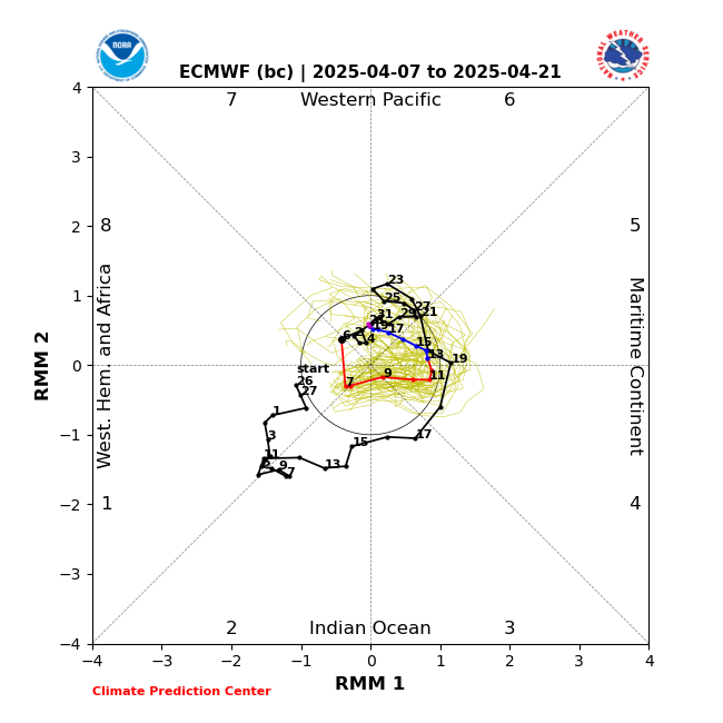
BOMM - has not updated yet from down under:
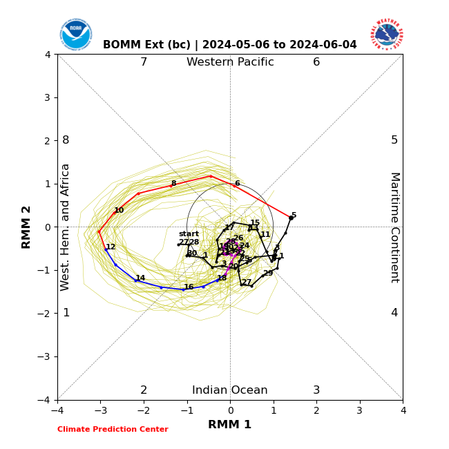
Could this happen and help us for February?? Absolutely but it must happen 1st.

Last edited by amugs on Mon Jan 08, 2024 11:09 am; edited 1 time in total
_________________
Mugs
AKA:King: Snow Weenie
Self Proclaimed
WINTER 2014-15 : 55.12" +.02 for 6 coatings (avg. 35")
WINTER 2015-16 Total - 29.8" (Avg 35")
WINTER 2016-17 : 39.5" so far

amugs- Advanced Forecaster - Mod
- Posts : 15130
Reputation : 213
Join date : 2013-01-07
Age : 54
Location : Hillsdale,NJ
Re: Long Range Thread 27.0
![]() by heehaw453 Mon Jan 08, 2024 10:36 am
by heehaw453 Mon Jan 08, 2024 10:36 am

heehaw453- Advanced Forecaster
- Posts : 3913
Reputation : 86
Join date : 2014-01-20
Location : Bedminster Township, PA Elevation 600' ASL
CPcantmeasuresnow and rb924119 like this post
Re: Long Range Thread 27.0
![]() by rb924119 Mon Jan 08, 2024 10:56 am
by rb924119 Mon Jan 08, 2024 10:56 am
[/quote]tomsriversnowstorm wrote:So Rb should we not expect any snow chances now for this winter. Nothing really looks great storm wise the next few weeks. Now yiur saying we have no chance after that. Is that correct?
quote="rb924119"]Frank_Wx wrote:
Yeah, this is only the beginning, I think. But I think it’s going to be much slower to rotate through this time. I’d watch for trends of slowing the propagation down in subsequent runs. Not good.
No, the next couple/three weeks should deliver more opportunities. As we close out January (say the transition starts around the 25th, give or take), that’s when I think it will start becoming more hostile for snow chances. But again, I want to take a better look at this before writing anything off completely, because there are other factors than just the MJO, and depending on how they interact, it may have more bark than bite.
rb924119- Meteorologist
- Posts : 7037
Reputation : 195
Join date : 2013-02-06
Age : 32
Location : Greentown, Pa
heehaw453 likes this post
Re: Long Range Thread 27.0
![]() by amugs Mon Jan 08, 2024 12:05 pm
by amugs Mon Jan 08, 2024 12:05 pm
N NAO, AO
N EPO and a PNA spike - ridge over the west coast and building east.

_________________
Mugs
AKA:King: Snow Weenie
Self Proclaimed
WINTER 2014-15 : 55.12" +.02 for 6 coatings (avg. 35")
WINTER 2015-16 Total - 29.8" (Avg 35")
WINTER 2016-17 : 39.5" so far
amugs- Advanced Forecaster - Mod
- Posts : 15130
Reputation : 213
Join date : 2013-01-07
Age : 54
Location : Hillsdale,NJ
rb924119, heehaw453 and Irish like this post
Re: Long Range Thread 27.0
![]() by dkodgis Mon Jan 08, 2024 2:58 pm
by dkodgis Mon Jan 08, 2024 2:58 pm

dkodgis- Senior Enthusiast
- Posts : 2671
Reputation : 98
Join date : 2013-12-29
Re: Long Range Thread 27.0
![]() by Irish Mon Jan 08, 2024 3:00 pm
by Irish Mon Jan 08, 2024 3:00 pm
15-16th, correct?amugs wrote:This is an exciting look for next Tuesdayish timeframe
N NAO, AO
N EPO and a PNA spike - ridge over the west coast and building east.
Irish- Pro Enthusiast
- Posts : 788
Reputation : 19
Join date : 2019-01-16
Age : 46
Location : Old Bridge, NJ
amugs and phil155 like this post
Re: Long Range Thread 27.0
![]() by amugs Mon Jan 08, 2024 3:31 pm
by amugs Mon Jan 08, 2024 3:31 pm
Irish wrote:15-16th, correct?amugs wrote:This is an exciting look for next Tuesdayish timeframe
N NAO, AO
N EPO and a PNA spike - ridge over the west coast and building east.
15th to 17th time frame
_________________
Mugs
AKA:King: Snow Weenie
Self Proclaimed
WINTER 2014-15 : 55.12" +.02 for 6 coatings (avg. 35")
WINTER 2015-16 Total - 29.8" (Avg 35")
WINTER 2016-17 : 39.5" so far
amugs- Advanced Forecaster - Mod
- Posts : 15130
Reputation : 213
Join date : 2013-01-07
Age : 54
Location : Hillsdale,NJ
Re: Long Range Thread 27.0
![]() by heehaw453 Mon Jan 08, 2024 4:43 pm
by heehaw453 Mon Jan 08, 2024 4:43 pm
heehaw453- Advanced Forecaster
- Posts : 3913
Reputation : 86
Join date : 2014-01-20
Location : Bedminster Township, PA Elevation 600' ASL
sroc4, CPcantmeasuresnow, Grselig and Brookster like this post
Page 30 of 40 • 1 ... 16 ... 29, 30, 31 ... 35 ... 40 ![]()