
 Search
January 2024 Observations and Discussion
Page 17 of 26 •  1 ... 10 ... 16, 17, 18 ... 21 ... 26
 ![]()
Re: January 2024 Observations and Discussion
![]() by jmanley32 Thu Jan 18, 2024 3:46 pm
by jmanley32 Thu Jan 18, 2024 3:46 pm
jmanley32- Senior Enthusiast

- Posts : 20595
Join date : 2013-12-12
Re: January 2024 Observations and Discussion
![]() by aiannone Thu Jan 18, 2024 3:47 pm
by aiannone Thu Jan 18, 2024 3:47 pm
heehaw453 wrote:The h5 trough is impressive and the key is the strengthening as it moves towards the coast. Heaviest with this IMO as shown would be south of I78. There is still is wiggle room 25-30 miles IMO

There is going to be nasty subsidence/dry air to the north of wherever this band sets up. Likely this will be north of I-78 as you said. I think NYC/LI and especially north of the city should really temper expectations and watch for subsidence/dry air to the north of the action down south
aiannone- Senior Enthusiast - Mod

- Posts : 4819
Join date : 2013-01-07
MattyICE and JT33 like this post
Re: January 2024 Observations and Discussion
![]() by tomsriversnowstorm Thu Jan 18, 2024 3:57 pm
by tomsriversnowstorm Thu Jan 18, 2024 3:57 pm
It is actually good for many on the board.
quote="aiannone"]ooof 18z nam is rough

[/quote]
tomsriversnowstorm- Posts : 90
Reputation : 0
Join date : 2021-02-06
Re: January 2024 Observations and Discussion
![]() by heehaw453 Thu Jan 18, 2024 4:09 pm
by heehaw453 Thu Jan 18, 2024 4:09 pm
Below is forecast discussion from Mt Holly. Even if it busts cannot fault them for going all in based on the setup IMO.

A closed H5 low will move into the Northern Plains, upper Midwest
and upper Great Lakes tonight, with a trough extending down through
the lower Great Lakes and into the Ohio Valley. One area of low
pressure will develop off the coast of Cape Hatteras, while a
secondary low will form several hundred miles west of that low. The
primary low drifts out to sea on Friday while the secondary low
works its way across the region Friday before merging with the
offshore low and then pulling out to sea. Meanwhile, as the upper
trough approaches from the west, it will take on a negative tilt as
it moves towards the Northeast. With the negatively tilted trough
over the Northeast, can expect bands of snow to continue to develop
through Friday afternoon and into Friday evening even with the
surface low offshore.
Based on the latest model guidance, snowfall totals have increased
over the area. A stripe of 5 to 6 inches of snow with locally higher
amounts will develop across the central portion of the forecast
area, from Chester county, through Philadelphia, and across the I-
195 corridor in New Jersey. For these areas, the Winter Weather
Advisory was upgraded to a Winter Storm Warning. For Monmouth
county, now expecting in excess of 6 inches of snow, so upgraded to
a Winter Storm Warning there as well. Went ahead and added Cape May
county and the coastal strip to the Winter Weather Advisory. Although
there will be rain mixed with the snow due to easterly flow ushering
relatively warmer air off the ocean, snowfall totals have increased
to around 2 inches.
What to watch out for: Bands of heavier snow may enhance the wet
bulb effect, resulting in colder surface temperatures and higher
liquid to snow ratios. This will result in locally higher snow
amounts. Overall, liquid to snow ratios will be on the order of 14:1
to 17:1, but could get as high as 20:1.
A cold front then moves across the area Friday night and
temperatures tumble into the teens. Any untreated surfaces will
become icy.
heehaw453- Advanced Forecaster

- Posts : 3906
Reputation : 86
Join date : 2014-01-20
Location : Bedminster Township, PA Elevation 600' ASL
SENJsnowman likes this post
Re: January 2024 Observations and Discussion
![]() by phil155 Thu Jan 18, 2024 4:11 pm
by phil155 Thu Jan 18, 2024 4:11 pm
phil155- Pro Enthusiast

- Posts : 487
Reputation : 4
Join date : 2019-12-16
essexcountypete and heehaw453 like this post
Re: January 2024 Observations and Discussion
![]() by essexcountypete Thu Jan 18, 2024 4:27 pm
by essexcountypete Thu Jan 18, 2024 4:27 pm
I'm thinking we get the same subsidence-shunted 1.25" we got here on Monday, and we'll be happy that it's not tainted with the lovely "light glaze".phil155 wrote:I am thinking 1-2 inches is a reasonable call here in Edison, I can see how we double that but I think that is reasonable as I think I will be to the north of that band,

essexcountypete- Pro Enthusiast
- Posts : 783
Reputation : 12
Join date : 2013-12-09
Location : Bloomfield, NJ
heehaw453 and Sparky Sparticles like this post
Re: January 2024 Observations and Discussion
![]() by hyde345 Thu Jan 18, 2024 5:10 pm
by hyde345 Thu Jan 18, 2024 5:10 pm

hyde345- Pro Enthusiast
- Posts : 1082
Reputation : 48
Join date : 2013-01-08
Location : Hyde Park, NY
Re: January 2024 Observations and Discussion
![]() by phil155 Thu Jan 18, 2024 5:19 pm
by phil155 Thu Jan 18, 2024 5:19 pm
essexcountypete wrote:I'm thinking we get the same subsidence-shunted 1.25" we got here on Monday, and we'll be happy that it's not tainted with the lovely "light glaze".phil155 wrote:I am thinking 1-2 inches is a reasonable call here in Edison, I can see how we double that but I think that is reasonable as I think I will be to the north of that band,
I am expecting 1 to maybe 2 inches but hoping for an upside surprise but definitely not expecting it
phil155- Pro Enthusiast
- Posts : 487
Reputation : 4
Join date : 2019-12-16
essexcountypete likes this post
Re: January 2024 Observations and Discussion
![]() by Irish Thu Jan 18, 2024 5:20 pm
by Irish Thu Jan 18, 2024 5:20 pm

Irish- Pro Enthusiast
- Posts : 788
Reputation : 19
Join date : 2019-01-16
Age : 45
Location : Old Bridge, NJ
Re: January 2024 Observations and Discussion
![]() by snowday111 Thu Jan 18, 2024 5:54 pm
by snowday111 Thu Jan 18, 2024 5:54 pm
snowday111- Posts : 92
Reputation : 1
Join date : 2013-01-07
Location : Monroe Twp. NJ (Middlesex County)
kalleg and weatherwatchermom like this post
Re: January 2024 Observations and Discussion
![]() by weatherwatchermom Thu Jan 18, 2024 5:57 pm
by weatherwatchermom Thu Jan 18, 2024 5:57 pm
fingers crossedsnowday111 wrote:State of NJ employees are closed. Remote work only. East Brunswick schools are closed. Monroe Twp has called an early dismissal. It's going to be a tough call with the timing of this storm. If schools do open, they run the risk of having difficulty getting children and staff home safely due to the fact that they must stay open for at least 4 hours of instructional time for it to count as a day. At 1:00 or 1:30 it may be treacherous. If my school doesn't close I'm going to take a half day just to be safe. Can't take the chance that they will worry about staff who have to travel to get back home.

weatherwatchermom- Senior Enthusiast
- Posts : 3829
Reputation : 78
Join date : 2014-11-25
Location : Hazlet Township, NJ
kalleg likes this post
Re: January 2024 Observations and Discussion
![]() by Irish Thu Jan 18, 2024 6:17 pm
by Irish Thu Jan 18, 2024 6:17 pm
snowday111 wrote:State of NJ employees are closed. Remote work only. East Brunswick schools are closed. Monroe Twp has called an early dismissal. It's going to be a tough call with the timing of this storm. If schools do open, they run the risk of having difficulty getting children and staff home safely due to the fact that they must stay open for at least 4 hours of instructional time for it to count as a day. At 1:00 or 1:30 it may be treacherous. If my school doesn't close I'm going to take a half day just to be safe. Can't take the chance that they will worry about staff who have to travel to get back home.
That's a dumb call, looking for trouble there.
Irish- Pro Enthusiast
- Posts : 788
Reputation : 19
Join date : 2019-01-16
Age : 45
Location : Old Bridge, NJ
Re: January 2024 Observations and Discussion
![]() by kalleg Thu Jan 18, 2024 6:24 pm
by kalleg Thu Jan 18, 2024 6:24 pm
Agree--hard to know what will be happening in NJ, wherever one lives...but keeping students and their busses off the roads should be a high priority when weather conditions are yet to be definitively determined...Irish wrote:snowday111 wrote:State of NJ employees are closed. Remote work only. East Brunswick schools are closed. Monroe Twp has called an early dismissal. It's going to be a tough call with the timing of this storm. If schools do open, they run the risk of having difficulty getting children and staff home safely due to the fact that they must stay open for at least 4 hours of instructional time for it to count as a day. At 1:00 or 1:30 it may be treacherous. If my school doesn't close I'm going to take a half day just to be safe. Can't take the chance that they will worry about staff who have to travel to get back home.
That's a dumb call, looking for trouble there.
kalleg- Posts : 156
Reputation : 2
Join date : 2013-01-15
Location : New Hope, PA
weatherwatchermom likes this post
Re: January 2024 Observations and Discussion
![]() by amugs Thu Jan 18, 2024 6:40 pm
by amugs Thu Jan 18, 2024 6:40 pm
_________________
Mugs
AKA:King: Snow Weenie
Self Proclaimed
WINTER 2014-15 : 55.12" +.02 for 6 coatings (avg. 35")
WINTER 2015-16 Total - 29.8" (Avg 35")
WINTER 2016-17 : 39.5" so far

amugs- Advanced Forecaster - Mod
- Posts : 15095
Reputation : 213
Join date : 2013-01-07
Age : 54
Location : Hillsdale,NJ
SENJsnowman likes this post
Re: January 2024 Observations and Discussion
![]() by jmanley32 Thu Jan 18, 2024 6:52 pm
by jmanley32 Thu Jan 18, 2024 6:52 pm

jmanley32- Senior Enthusiast
- Posts : 20595
Reputation : 108
Join date : 2013-12-12
Age : 43
Location : Yonkers, NY
SENJsnowman likes this post
Re: January 2024 Observations and Discussion
![]() by MattyICE Thu Jan 18, 2024 7:12 pm
by MattyICE Thu Jan 18, 2024 7:12 pm
amugs wrote:
Jeez mugs. You can literally SEE upton on that map. Lol. Wild.
MattyICE- Advanced Forecaster
- Posts : 249
Reputation : 6
Join date : 2017-11-10
Age : 39
Location : Clifton, NJ (Eastern Passaic County)
Re: January 2024 Observations and Discussion
![]() by silentwreck Thu Jan 18, 2024 7:26 pm
by silentwreck Thu Jan 18, 2024 7:26 pm
silentwreck- Posts : 45
Reputation : 0
Join date : 2023-12-18
Location : Queens, NY
essexcountypete likes this post
Re: January 2024 Observations and Discussion
![]() by jmanley32 Thu Jan 18, 2024 7:29 pm
by jmanley32 Thu Jan 18, 2024 7:29 pm
Love the wish comment, whats ur scientific backing that it would come more north? LOL totally kidding, I hope so too but my guess is 0-4.silentwreck wrote:Hopefully that axis of heavy snow moves a bit north to the NYC area! Wouldn’t be surprised to see that happen. Or wouldn’t be surprised if we get under 1 inch either lol
jmanley32- Senior Enthusiast
- Posts : 20595
Reputation : 108
Join date : 2013-12-12
Age : 43
Location : Yonkers, NY
Re: January 2024 Observations and Discussion
![]() by uanswer2me Thu Jan 18, 2024 7:30 pm
by uanswer2me Thu Jan 18, 2024 7:30 pm
silentwreck wrote:Hopefully that axis of heavy snow moves a bit north to the NYC area! Wouldn’t be surprised to see that happen. Or wouldn’t be surprised if we get under 1 inch either lol
Hopefully it doesn't, stop trying to steal my snow.
uanswer2me- Posts : 27
Reputation : 0
Join date : 2022-01-14
silentwreck likes this post
Re: January 2024 Observations and Discussion
![]() by jmanley32 Thu Jan 18, 2024 8:16 pm
by jmanley32 Thu Jan 18, 2024 8:16 pm
jmanley32- Senior Enthusiast
- Posts : 20595
Reputation : 108
Join date : 2013-12-12
Age : 43
Location : Yonkers, NY
Re: January 2024 Observations and Discussion
![]() by phil155 Thu Jan 18, 2024 8:23 pm
by phil155 Thu Jan 18, 2024 8:23 pm
phil155- Pro Enthusiast
- Posts : 487
Reputation : 4
Join date : 2019-12-16
Irish likes this post
Re: January 2024 Observations and Discussion
![]() by jmanley32 Thu Jan 18, 2024 8:36 pm
by jmanley32 Thu Jan 18, 2024 8:36 pm
NJ I get, many many schools in NJ are early dismissal, the WWA and WSW is for early morning to the evening so I am not sure why they are chancing that.phil155 wrote:Edison schools are closed tomorrow as well
jmanley32- Senior Enthusiast
- Posts : 20595
Reputation : 108
Join date : 2013-12-12
Age : 43
Location : Yonkers, NY
Re: January 2024 Observations and Discussion
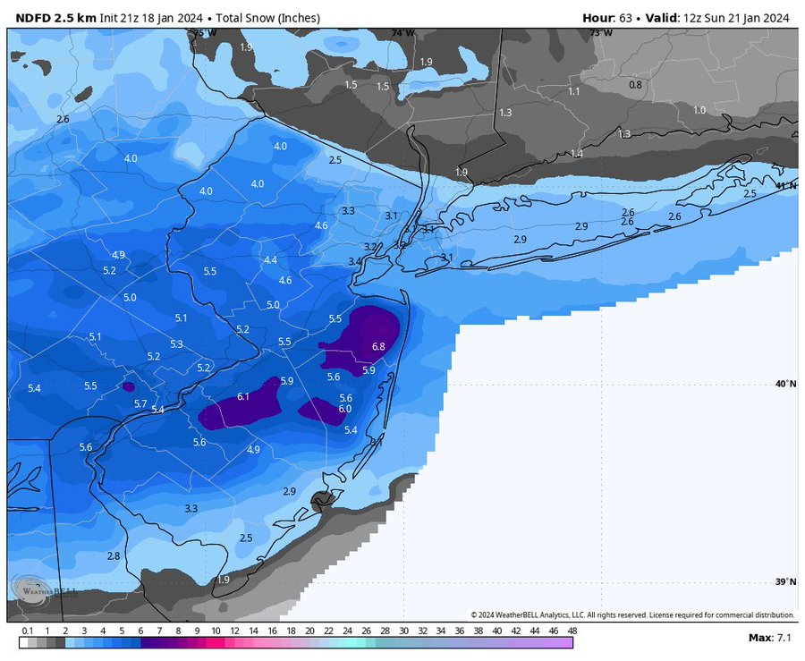
![]() by SENJsnowman Thu Jan 18, 2024 8:48 pm
by SENJsnowman Thu Jan 18, 2024 8:48 pm
Here are the goal posts for the Jersey Shore from about mid Ocean County on up to Sandy Hook and for most of those interior counties as well. This I’m feeling pretty sure of. I have no idea about anything as far as what to expect. So just hoping for the best for all of us.


SENJsnowman- Senior Enthusiast
- Posts : 1189
Reputation : 61
Join date : 2017-01-06
Age : 51
Location : Bayville, NJ
Re: January 2024 Observations and Discussion
![]() by jmanley32 Thu Jan 18, 2024 8:50 pm
by jmanley32 Thu Jan 18, 2024 8:50 pm

Last edited by jmanley32 on Thu Jan 18, 2024 8:53 pm; edited 1 time in total
jmanley32- Senior Enthusiast
- Posts : 20595
Reputation : 108
Join date : 2013-12-12
Age : 43
Location : Yonkers, NY
Re: January 2024 Observations and Discussion
![]() by phil155 Thu Jan 18, 2024 8:53 pm
by phil155 Thu Jan 18, 2024 8:53 pm
jmanley32 wrote:NJ I get, many many schools in NJ are early dismissal, the WWA and WSW is for early morning to the evening so I am not sure why they are chancing that.phil155 wrote:Edison schools are closed tomorrow as well
Kids are very happy, some of them don’t care if it snows they just want to sleep in and hang out. When i was young a snow day was an opportunity to make some money shoveling. No kids ever come around anymore looking to shovel. I don’t get it
phil155- Pro Enthusiast
- Posts : 487
Reputation : 4
Join date : 2019-12-16
Re: January 2024 Observations and Discussion
![]() by jmanley32 Thu Jan 18, 2024 8:54 pm
by jmanley32 Thu Jan 18, 2024 8:54 pm
Me too, I used to make bank. I understand why, way to dangerous to have kids just going to random houses nowadays. recipe for various things, good way to never see ur kids again. Plus I think you have to be at least 12 to go out on your own without an adult but not sure.phil155 wrote:jmanley32 wrote:NJ I get, many many schools in NJ are early dismissal, the WWA and WSW is for early morning to the evening so I am not sure why they are chancing that.phil155 wrote:Edison schools are closed tomorrow as well
Kids are very happy, some of them don’t care if it snows they just want to sleep in and hang out. When i was young a snow day was an opportunity to make some money shoveling. No kids ever come around anymore looking to shovel. I don’t get it
Last edited by jmanley32 on Thu Jan 18, 2024 9:13 pm; edited 1 time in total
jmanley32- Senior Enthusiast
- Posts : 20595
Reputation : 108
Join date : 2013-12-12
Age : 43
Location : Yonkers, NY
silentwreck likes this post
Re: January 2024 Observations and Discussion
![]() by Dunnzoo Thu Jan 18, 2024 8:56 pm
by Dunnzoo Thu Jan 18, 2024 8:56 pm
_________________
Janet
Snowfall winter of 2023-2024 17.5"
Snowfall winter of 2022-2023 6.0"
Snowfall winter of 2021-2022 17.6" 1" sleet 2/25/22
Snowfall winter of 2020-2021 51.1"
Snowfall winter of 2019-2020 8.5"
Snowfall winter of 2018-2019 25.1"
Snowfall winter of 2017-2018 51.9"
Snowfall winter of 2016-2017 45.6"
Snowfall winter of 2015-2016 29.5"
Snowfall winter of 2014-2015 50.55"
Snowfall winter of 2013-2014 66.5"

Dunnzoo- Senior Enthusiast - Mod
- Posts : 4912
Reputation : 68
Join date : 2013-01-11
Age : 62
Location : Westwood, NJ
jmanley32 likes this post
Page 17 of 26 • 1 ... 10 ... 16, 17, 18 ... 21 ... 26 ![]()
|
|
|