01/22/16-01/23/16 Update #1 - Historic Storm Possible
+45
nnjwxguy78
lglickman1
jwalsh
Teetghhuhnbhj
Sunflowers138
Dave1978
devsman
Cyanide02Z06
Grselig
track17
Dunnzoo
Dtone
CPcantmeasuresnow
weatherwatchermom
aiannone
jimv45
Biggin23
billg315
docstox12
Quietace
GreyBeard
RJB8525
Snowfall
frank 638
Joe Snow
SNOW MAN
jmanley32
chief7
rb924119
Artechmetals
Math23x7
algae888
Abba701
SoulSingMG
sroc4
mako460
skinsfan1177
nutleyblizzard
jake732
amugs
oldtimer
hyde345
snow247
NjWeatherGuy
Frank_Wx
49 posters
Page 10 of 26
Page 10 of 26 •  1 ... 6 ... 9, 10, 11 ... 18 ... 26
 Re: 01/22/16-01/23/16 Update #1 - Historic Storm Possible
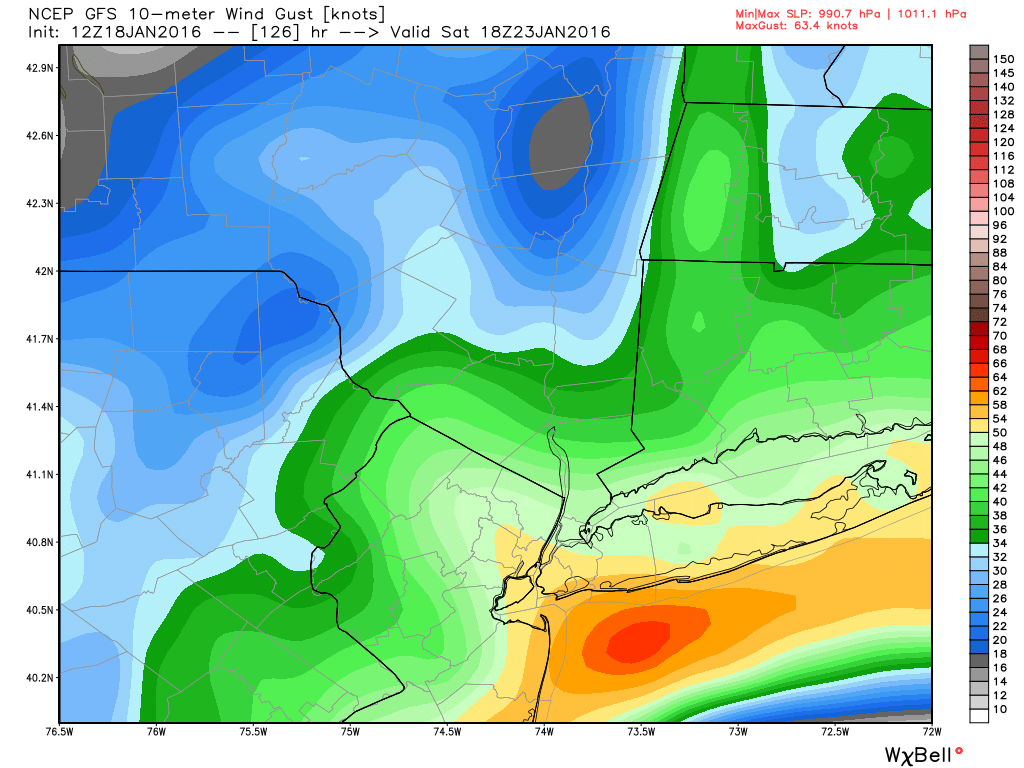
Frank_Wx wrote:Wind gusts at height of storm
Wow. Can't remember the last time I've seen the yellow like that over Manhattan in a winter storm.
SoulSingMG- Senior Enthusiast

- Posts : 2853
Join date : 2013-12-11
 Re: 01/22/16-01/23/16 Update #1 - Historic Storm Possible

_________________
_______________________________________________________________________________________________________
CLICK HERE to view NJ Strong Snowstorm Classifications
 Re: 01/22/16-01/23/16 Update #1 - Historic Storm Possible
Frank_Wx wrote:
that looks a little low
_________________
-Alex Iannone-

aiannone- Senior Enthusiast - Mod

- Posts : 4828
Reputation : 92
Join date : 2013-01-07
Location : Saint James, LI (Northwest Suffolk Co.)
 Re: 01/22/16-01/23/16 Update #1 - Historic Storm Possible
Frank_Wx wrote:Wind gusts at height of storm
EURO yesterday 12z had 50+ into CNJ but thats splitting hairs still impressive. Theres obviously a storm here but too much time on the clock to run down. Hopefully the models hold their ground, CMC up next. Ill calm down if we see the EURO come back NW today.
NjWeatherGuy- Advanced Forecaster

- Posts : 4100
Reputation : 28
Join date : 2013-01-06
Location : Belle Mead, NJ
 Re: 01/22/16-01/23/16 Update #1 - Historic Storm Possible
The CMC is about to show a Frankzilla.
_________________
_______________________________________________________________________________________________________
CLICK HERE to view NJ Strong Snowstorm Classifications
 Re: 01/22/16-01/23/16 Update #1 - Historic Storm Possible
CMC


_________________
_______________________________________________________________________________________________________
CLICK HERE to view NJ Strong Snowstorm Classifications
 Re: 01/22/16-01/23/16 Update #1 - Historic Storm Possible
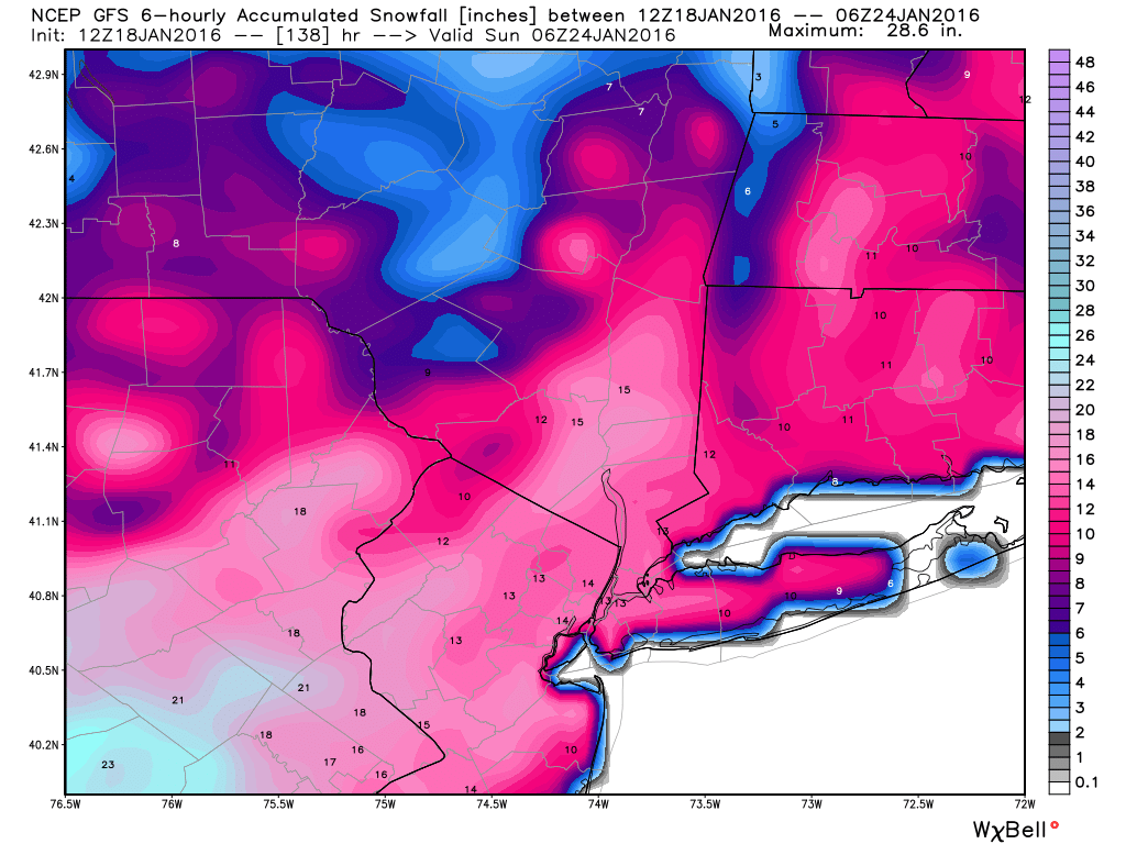
Assuming 15:1 ratio this is 18"-24" for all.

snow247- Pro Enthusiast

- Posts : 2417
Reputation : 0
Join date : 2014-08-27
Location : Mount Ivy, NY - Elevation 545'
 Re: 01/22/16-01/23/16 Update #1 - Historic Storm Possible
I cannot believe what I am seeing


_________________
_______________________________________________________________________________________________________
CLICK HERE to view NJ Strong Snowstorm Classifications
 Re: 01/22/16-01/23/16 Update #1 - Historic Storm Possible


_________________
_______________________________________________________________________________________________________
CLICK HERE to view NJ Strong Snowstorm Classifications
 Re: 01/22/16-01/23/16 Update #1 - Historic Storm Possible
That buries Binghamton too!
_________________
-Alex Iannone-

aiannone- Senior Enthusiast - Mod

- Posts : 4828
Reputation : 92
Join date : 2013-01-07
Location : Saint James, LI (Northwest Suffolk Co.)
 Re: 01/22/16-01/23/16 Update #1 - Historic Storm Possible
THE CMC HAS LOST ITS MIND!!!!!!!!!!!!!!!!!!!!!!!!!! FRANKZILLA!!!!!!!!!!!!!!!!!!!!!!!!!!!
_________________
_______________________________________________________________________________________________________
CLICK HERE to view NJ Strong Snowstorm Classifications
 Re: 01/22/16-01/23/16 Update #1 - Historic Storm Possible
We're looking at a 20-30 hour snowfall. Not those 8-12 hours events from last year.


_________________
_______________________________________________________________________________________________________
CLICK HERE to view NJ Strong Snowstorm Classifications
 Re: 01/22/16-01/23/16 Update #1 - Historic Storm Possible
And this is just a few days away. Wow.

snow247- Pro Enthusiast

- Posts : 2417
Reputation : 0
Join date : 2014-08-27
Location : Mount Ivy, NY - Elevation 545'
 Re: 01/22/16-01/23/16 Update #1 - Historic Storm Possible
snow247 wrote:Assuming 15:1 ratio this is 18"-24" for all.
Not gonna be that high for many. Looks like a pasty storm with temps in the low 30s for I95 probably upper 20s too. Where you are probably colder. Models dont seem to think this will be a high ratio event probably due to warm ocean and east flow but the tradeoff is a ton of QPF and potential monster storm. Id rather have that. Probably a 10:1 to 12:1 ratio event for most if it plays out as modeled.

NjWeatherGuy- Advanced Forecaster

- Posts : 4100
Reputation : 28
Join date : 2013-01-06
Location : Belle Mead, NJ
 Re: 01/22/16-01/23/16 Update #1 - Historic Storm Possible
Looking at models, there is a really tight gradient between the LP and where the R/S line is. While you can see the 32F line fairly north, most are at 33 degrees with every other column cool enough for snow. Almost everyone is ripping except SE NJ

Quietace- Meteorologist - Mod

- Posts : 3689
Reputation : 33
Join date : 2013-01-07
Age : 27
Location : Point Pleasant, NJ
 Re: 01/22/16-01/23/16 Update #1 - Historic Storm Possible
This storm is NOT far away. By 00z runs tonight, we're looking at things under 90 hours.
_________________
_______________________________________________________________________________________________________
CLICK HERE to view NJ Strong Snowstorm Classifications
 Re: 01/22/16-01/23/16 Update #1 - Historic Storm Possible
With 2 feet of snow maybe more and drifts of 10 feet.Frank_Wx wrote:The east winds are very strong. Jersey coast will see almost hurricane force winds.


skinsfan1177- Senior Enthusiast

- Posts : 4485
Reputation : 35
Join date : 2013-01-07
Age : 47
Location : Point Pleasant Boro
 Re: 01/22/16-01/23/16 Update #1 - Historic Storm Possible
Frank_Wx wrote:We're looking at a 20-30 hour snowfall. Not those 8-12 hours events from last year.
Worried about this because some events in the past years were progged to do this, can recall many and it turned out to be smoke and mirrors meanwhile it ended up a much quicker event as we got closer with less QPF. Something to look out for, also like the CMC where it is, usually a little too far NW and warm anyway.

NjWeatherGuy- Advanced Forecaster

- Posts : 4100
Reputation : 28
Join date : 2013-01-06
Location : Belle Mead, NJ
 Re: 01/22/16-01/23/16 Update #1 - Historic Storm Possible
Cnj coast will be getting hammered if this here ya weds sound the alarms

skinsfan1177- Senior Enthusiast

- Posts : 4485
Reputation : 35
Join date : 2013-01-07
Age : 47
Location : Point Pleasant Boro
 Re: 01/22/16-01/23/16 Update #1 - Historic Storm Possible
So constantly forecasted, reminds me of 96
Dtone- Wx Statistician Guru

- Posts : 1738
Reputation : 9
Join date : 2013-08-26
Location : Bronx, NY
 Re: 01/22/16-01/23/16 Update #1 - Historic Storm Possible
Quietace wrote:Looking at models, there is a really tight gradient between the LP and where the R/S line is. While you can see the 32F line fairly north, most are at 33 degrees with every other column cool enough for snow. Almost everyone is ripping except SE NJ
It'll be in NAM range soon and then we'll be able to see where these finer details are. Like the psu maps for those. Assuming the NAM can handle the setup...

NjWeatherGuy- Advanced Forecaster

- Posts : 4100
Reputation : 28
Join date : 2013-01-06
Location : Belle Mead, NJ
 Re: 01/22/16-01/23/16 Update #1 - Historic Storm Possible
SoulSingMG wrote:Frank_Wx wrote:Wind gusts at height of storm
Wow. Can't remember the last time I've seen the yellow like that over Manhattan in a winter storm.
How about Sandy??
_________________
Mugs
AKA:King: Snow Weenie
Self Proclaimed
WINTER 2014-15 : 55.12" +.02 for 6 coatings (avg. 35")
WINTER 2015-16 Total - 29.8" (Avg 35")
WINTER 2016-17 : 39.5" so far

amugs- Advanced Forecaster - Mod

- Posts : 15156
Reputation : 213
Join date : 2013-01-07
Age : 54
Location : Hillsdale,NJ
 Re: 01/22/16-01/23/16 Update #1 - Historic Storm Possible
LOL...I have been delirious with a high fever the last 2 days...am I hallucinating or are we really going to have a storm??

weatherwatchermom- Senior Enthusiast

- Posts : 3895
Reputation : 78
Join date : 2014-11-25
Location : Hazlet Township, NJ
 Re: 01/22/16-01/23/16 Update #1 - Historic Storm Possible
No model will really be able to handle the dynamics of a setup like this, the gradient is going to be extremely tight. Though with this storm, you may be at 33-34 degrees with accumulating snow on all surfaces with the rates shown, especially with the stronger confluence pressing down coller air into the area as shown on the GFS.NjWeatherGuy wrote:Quietace wrote:Looking at models, there is a really tight gradient between the LP and where the R/S line is. While you can see the 32F line fairly north, most are at 33 degrees with every other column cool enough for snow. Almost everyone is ripping except SE NJ
It'll be in NAM range soon and then we'll be able to see where these finer details are. Like the psu maps for those. Assuming the NAM can handle the setup...

Quietace- Meteorologist - Mod

- Posts : 3689
Reputation : 33
Join date : 2013-01-07
Age : 27
Location : Point Pleasant, NJ
 Re: 01/22/16-01/23/16 Update #1 - Historic Storm Possible
Frank_Wx wrote:
I'm HIGHLY intrigued by these two maps. Look at the double CCB banding that it is depicting. No, that's not incorrect. When you have systems that rapidly mature, especially at mid levels, you can actually get dual CCB banding. The method by which this is occurs is very hard to explain, but I have seen the CMC do this now for multiple runs, and demonstrates the explosive POTENTIAL of this system. That said, whoever gets trapped between the two bands gets the ultimate screw-job. Gonna be interesting to see where the models converge, because whoever gets under those two bands will jackpot, and I mean LARGELY.
rb924119- Meteorologist

- Posts : 7112
Reputation : 195
Join date : 2013-02-06
Age : 32
Location : Greentown, Pa
 Re: 01/22/16-01/23/16 Update #1 - Historic Storm Possible
weatherwatchermom wrote:LOL...I have been delirious with a high fever the last 2 days...am I hallucinating or are we really going to have a storm??
Sure looks like it.
My 2nd update will come tonight. Between 8-9pm.
I will begin talking a bit more specifics. Key EURO run this afternoon.
_________________
_______________________________________________________________________________________________________
CLICK HERE to view NJ Strong Snowstorm Classifications
Page 10 of 26 •  1 ... 6 ... 9, 10, 11 ... 18 ... 26
Page 10 of 26
Permissions in this forum:
You cannot reply to topics in this forum
 Home
Home