01/22/16-01/23/16 Update #1 - Historic Storm Possible
+45
nnjwxguy78
lglickman1
jwalsh
Teetghhuhnbhj
Sunflowers138
Dave1978
devsman
Cyanide02Z06
Grselig
track17
Dunnzoo
Dtone
CPcantmeasuresnow
weatherwatchermom
aiannone
jimv45
Biggin23
billg315
docstox12
Quietace
GreyBeard
RJB8525
Snowfall
frank 638
Joe Snow
SNOW MAN
jmanley32
chief7
rb924119
Artechmetals
Math23x7
algae888
Abba701
SoulSingMG
sroc4
mako460
skinsfan1177
nutleyblizzard
jake732
amugs
oldtimer
hyde345
snow247
NjWeatherGuy
Frank_Wx
49 posters
Page 11 of 26
Page 11 of 26 •  1 ... 7 ... 10, 11, 12 ... 18 ... 26
 Re: 01/22/16-01/23/16 Update #1 - Historic Storm Possible
Frank_Wx wrote:
I'm HIGHLY intrigued by these two maps. Look at the double CCB banding that it is depicting. No, that's not incorrect. When you have systems that rapidly mature, especially at mid levels, you can actually get dual CCB banding. The method by which this is occurs is very hard to explain, but I have seen the CMC do this now for multiple runs, and demonstrates the explosive POTENTIAL of this system. That said, whoever gets trapped between the two bands gets the ultimate screw-job. Gonna be interesting to see where the models converge, because whoever gets under those two bands will jackpot, and I mean LARGELY.
rb924119- Meteorologist

- Posts : 7110
Join date : 2013-02-06
 Re: 01/22/16-01/23/16 Update #1 - Historic Storm Possible
weatherwatchermom wrote:LOL...I have been delirious with a high fever the last 2 days...am I hallucinating or are we really going to have a storm??
Sure looks like it.
My 2nd update will come tonight. Between 8-9pm.
I will begin talking a bit more specifics. Key EURO run this afternoon.
 Re: 01/22/16-01/23/16 Update #1 - Historic Storm Possible
[quote="NjWeatherGuy"]
It'll be in NAM range soon and then we'll be able to see where these finer details are. Like the psu maps for those. Assuming the NAM can handle the setup...[/quote
The NAM HAHAHA dude and dude yes we go with the RGEM this will and always brings us the goods.
FN EPIC RUNS!
Juse got up(remember I am recouping from surgery no pop shots please!):and I am calm by the runs from the consistent BOMBS we r seeing. I say this no neg or ready to jump ship idmf we see a pull back or a hiccup models do this with these BEHEMOTHS yes that term so we be patience and persevere Carry on my NJ Strong Family.
]
Quietace wrote:Looking at models, there is a really tight gradient between the LP and where the R/S line is. While you can see the 32F line fairly north, most are at 33 degrees with every other column cool enough for snow. Almost everyone is ripping except SE NJ
It'll be in NAM range soon and then we'll be able to see where these finer details are. Like the psu maps for those. Assuming the NAM can handle the setup...[/quote
The NAM HAHAHA dude and dude yes we go with the RGEM this will and always brings us the goods.
FN EPIC RUNS!
Juse got up(remember I am recouping from surgery no pop shots please!):and I am calm by the runs from the consistent BOMBS we r seeing. I say this no neg or ready to jump ship idmf we see a pull back or a hiccup models do this with these BEHEMOTHS yes that term so we be patience and persevere Carry on my NJ Strong Family.
]
_________________
Mugs
AKA:King: Snow Weenie
Self Proclaimed
WINTER 2014-15 : 55.12" +.02 for 6 coatings (avg. 35")
WINTER 2015-16 Total - 29.8" (Avg 35")
WINTER 2016-17 : 39.5" so far

amugs- Advanced Forecaster - Mod

- Posts : 15154
Reputation : 213
Join date : 2013-01-07
Age : 54
Location : Hillsdale,NJ
 Re: 01/22/16-01/23/16 Update #1 - Historic Storm Possible
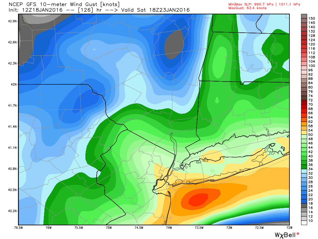
amugs wrote:SoulSingMG wrote:Frank_Wx wrote:Wind gusts at height of storm
Wow. Can't remember the last time I've seen the yellow like that over Manhattan in a winter storm.
How about Sandy??
"Winter storm." ;-)
I'd really like to point out that we have a FULL WOLF MOON on Sat night; if this pans out, coastal flooding in prone areas will be major.

SoulSingMG- Senior Enthusiast

- Posts : 2853
Reputation : 74
Join date : 2013-12-11
Location : Long Island City, NY
 Re: 01/22/16-01/23/16 Update #1 - Historic Storm Possible
Cnj coast is doomed

skinsfan1177- Senior Enthusiast

- Posts : 4485
Reputation : 35
Join date : 2013-01-07
Age : 47
Location : Point Pleasant Boro
 Re: 01/22/16-01/23/16 Update #1 - Historic Storm Possible
Quietace wrote:No model will really be able to handle the dynamics of a setup like this, the gradient is going to be extremely tight. Though with this storm, you may be at 33-34 degrees with accumulating snow on all surfaces with the rates shown, especially with the stronger confluence pressing down coller air into the area as shown on the GFS.NjWeatherGuy wrote:Quietace wrote:Looking at models, there is a really tight gradient between the LP and where the R/S line is. While you can see the 32F line fairly north, most are at 33 degrees with every other column cool enough for snow. Almost everyone is ripping except SE NJ
It'll be in NAM range soon and then we'll be able to see where these finer details are. Like the psu maps for those. Assuming the NAM can handle the setup...
When you have a storm bombing out like this one is forecast to do and a closed 500 MB low right near or south of us the sheer dynamics should cause temps to crash into the mid 20's no??????????????????????
Guest- Guest
 Re: 01/22/16-01/23/16 Update #1 - Historic Storm Possible
SoulSingMG wrote:amugs wrote:SoulSingMG wrote:Frank_Wx wrote:Wind gusts at height of storm
Wow. Can't remember the last time I've seen the yellow like that over Manhattan in a winter storm.
How about Sandy??
"Winter storm." ;-)
I'd really like to point out that we have a FULL WOLF MOON on Sat night; if this pans out, coastal flooding in prone areas will be major.
That's not good. We all love a good blizzard but none of us want to see flooding, extreme high winds, and coastal damage. Well maybe with the exception of Jman. JK

CPcantmeasuresnow- Wx Statistician Guru

- Posts : 7286
Reputation : 230
Join date : 2013-01-07
Age : 103
Location : Eastern Orange County, NY
 Re: 01/22/16-01/23/16 Update #1 - Historic Storm Possible
............and not to be too selfish, but with 2"+ qpf area wide at 10:1 minimum..........do the math!!!!!!!!!!!!!!
Guest- Guest
 Re: 01/22/16-01/23/16 Update #1 - Historic Storm Possible
There will also be a full moon this weekend.
_________________
_______________________________________________________________________________________________________
CLICK HERE to view NJ Strong Snowstorm Classifications
 Re: 01/22/16-01/23/16 Update #1 - Historic Storm Possible
Not with the mid and low level center so close to the coast. Water temps are also fairly warm still yet more nominal then earlier in the month. Probably will keep coastal sections on edge, yet with current placement only ACY area and immediate coastal sections look like they will have problems with the screaming East wind.syosnow94 wrote:Quietace wrote:No model will really be able to handle the dynamics of a setup like this, the gradient is going to be extremely tight. Though with this storm, you may be at 33-34 degrees with accumulating snow on all surfaces with the rates shown, especially with the stronger confluence pressing down coller air into the area as shown on the GFS.NjWeatherGuy wrote:Quietace wrote:Looking at models, there is a really tight gradient between the LP and where the R/S line is. While you can see the 32F line fairly north, most are at 33 degrees with every other column cool enough for snow. Almost everyone is ripping except SE NJ
It'll be in NAM range soon and then we'll be able to see where these finer details are. Like the psu maps for those. Assuming the NAM can handle the setup...
When you have a storm bombing out like this one is forecast to do and a closed 500 MB low right near or south of us the sheer dynamics should cause temps to crash into the mid 20's no??????????????????????

Quietace- Meteorologist - Mod

- Posts : 3689
Reputation : 33
Join date : 2013-01-07
Age : 27
Location : Point Pleasant, NJ
 Re: 01/22/16-01/23/16 Update #1 - Historic Storm Possible
CMC has R/S line getting as north as between I-95 and I-78 but its not there for long.
NjWeatherGuy- Advanced Forecaster

- Posts : 4100
Reputation : 28
Join date : 2013-01-06
Location : Belle Mead, NJ
 Re: 01/22/16-01/23/16 Update #1 - Historic Storm Possible
Like I said, whoever is lucky enough to get under one of those bands is going to jackpot lol


rb924119- Meteorologist

- Posts : 7110
Reputation : 195
Join date : 2013-02-06
Age : 32
Location : Greentown, Pa
 Re: 01/22/16-01/23/16 Update #1 - Historic Storm Possible
Quietace wrote:Not with the mid and low level center so close to the coast. Water temps are also fairly warm still yet more nominal then earlier in the month. Probably will keep coastal sections on edge, yet with current placement only ACY area and immediate coastal sections look like they will have problems with the screaming East wind.syosnow94 wrote:Quietace wrote:No model will really be able to handle the dynamics of a setup like this, the gradient is going to be extremely tight. Though with this storm, you may be at 33-34 degrees with accumulating snow on all surfaces with the rates shown, especially with the stronger confluence pressing down coller air into the area as shown on the GFS.NjWeatherGuy wrote:Quietace wrote:Looking at models, there is a really tight gradient between the LP and where the R/S line is. While you can see the 32F line fairly north, most are at 33 degrees with every other column cool enough for snow. Almost everyone is ripping except SE NJ
It'll be in NAM range soon and then we'll be able to see where these finer details are. Like the psu maps for those. Assuming the NAM can handle the setup...
When you have a storm bombing out like this one is forecast to do and a closed 500 MB low right near or south of us the sheer dynamics should cause temps to crash into the mid 20's no??????????????????????
I can see mixing as far north as, well, probably where the coastal plain transitions to piedmont with this setup and such warm anomalies off the coast, it may only mix for a short time in northern areas and more further south, there will be tight gradients from the mixing (seen on models) and NW cutoff.

NjWeatherGuy- Advanced Forecaster

- Posts : 4100
Reputation : 28
Join date : 2013-01-06
Location : Belle Mead, NJ
 Re: 01/22/16-01/23/16 Update #1 - Historic Storm Possible
NjWeatherGuy wrote:CMC has R/S line getting as north as between I-95 and I-78 but its not there for long.
One of my all time favorite METS, Mr. Lee Goldberg, often says, "sometimes you've gotta sniff the rain to get the heaviest snows."

SoulSingMG- Senior Enthusiast

- Posts : 2853
Reputation : 74
Join date : 2013-12-11
Location : Long Island City, NY
 Re: 01/22/16-01/23/16 Update #1 - Historic Storm Possible
Looks like my prediction of the GFS ensemble correcting further northwest is coming true lol Ridge is significantly more amplified as is the trough through 78 
rb924119- Meteorologist

- Posts : 7110
Reputation : 195
Join date : 2013-02-06
Age : 32
Location : Greentown, Pa
 Re: 01/22/16-01/23/16 Update #1 - Historic Storm Possible
SoulSingMG wrote:NjWeatherGuy wrote:CMC has R/S line getting as north as between I-95 and I-78 but its not there for long.
One of my all time favorite METS, Mr. Lee Goldberg, often says, "sometimes you've gotta sniff the rain to get the heaviest snows."
Yep

NjWeatherGuy- Advanced Forecaster

- Posts : 4100
Reputation : 28
Join date : 2013-01-06
Location : Belle Mead, NJ
 Re: 01/22/16-01/23/16 Update #1 - Historic Storm Possible
GEFS might be about ready to go AWOL....awaiting patiently haha
rb924119- Meteorologist

- Posts : 7110
Reputation : 195
Join date : 2013-02-06
Age : 32
Location : Greentown, Pa
 Re: 01/22/16-01/23/16 Update #1 - Historic Storm Possible
I wouldn't say that. Not with such a dynamic system. Per the GFS, their is no warm nose at any level except in SNJNjWeatherGuy wrote:Quietace wrote:Not with the mid and low level center so close to the coast. Water temps are also fairly warm still yet more nominal then earlier in the month. Probably will keep coastal sections on edge, yet with current placement only ACY area and immediate coastal sections look like they will have problems with the screaming East wind.syosnow94 wrote:Quietace wrote:No model will really be able to handle the dynamics of a setup like this, the gradient is going to be extremely tight. Though with this storm, you may be at 33-34 degrees with accumulating snow on all surfaces with the rates shown, especially with the stronger confluence pressing down coller air into the area as shown on the GFS.NjWeatherGuy wrote:Quietace wrote:Looking at models, there is a really tight gradient between the LP and where the R/S line is. While you can see the 32F line fairly north, most are at 33 degrees with every other column cool enough for snow. Almost everyone is ripping except SE NJ
It'll be in NAM range soon and then we'll be able to see where these finer details are. Like the psu maps for those. Assuming the NAM can handle the setup...
When you have a storm bombing out like this one is forecast to do and a closed 500 MB low right near or south of us the sheer dynamics should cause temps to crash into the mid 20's no??????????????????????
I can see mixing as far north as, well, probably where the coastal plain transitions to piedmont with this setup and such warm anomalies off the coast, it may only mix for a short time in northern areas and more further south, there will be tight gradients from the mixing (seen on models) and NW cutoff.

Quietace- Meteorologist - Mod

- Posts : 3689
Reputation : 33
Join date : 2013-01-07
Age : 27
Location : Point Pleasant, NJ
 Re: 01/22/16-01/23/16 Update #1 - Historic Storm Possible
Will take anything over another damn miss to the east... Man this is overdue if it verifies...

NjWeatherGuy- Advanced Forecaster

- Posts : 4100
Reputation : 28
Join date : 2013-01-06
Location : Belle Mead, NJ
 Re: 01/22/16-01/23/16 Update #1 - Historic Storm Possible
rb924119 wrote:Like I said, whoever is lucky enough to get under one of those bands is going to jackpot lol
Hey mugsy! Look! That's us!

_________________
Janet
Snowfall winter of 2023-2024 17.5"
Snowfall winter of 2022-2023 6.0"
Snowfall winter of 2021-2022 17.6" 1" sleet 2/25/22
Snowfall winter of 2020-2021 51.1"
Snowfall winter of 2019-2020 8.5"
Snowfall winter of 2018-2019 25.1"
Snowfall winter of 2017-2018 51.9"
Snowfall winter of 2016-2017 45.6"
Snowfall winter of 2015-2016 29.5"
Snowfall winter of 2014-2015 50.55"
Snowfall winter of 2013-2014 66.5"
Dunnzoo- Senior Enthusiast - Mod

- Posts : 4937
Reputation : 68
Join date : 2013-01-11
Age : 62
Location : Westwood, NJ
 Re: 01/22/16-01/23/16 Update #1 - Historic Storm Possible
The immense dynamics of this beast will make/produce cold air and will cause temps to crash into the mid low 20's with that banana high sitting to the NW don't forget that.
_________________
Mugs
AKA:King: Snow Weenie
Self Proclaimed
WINTER 2014-15 : 55.12" +.02 for 6 coatings (avg. 35")
WINTER 2015-16 Total - 29.8" (Avg 35")
WINTER 2016-17 : 39.5" so far

amugs- Advanced Forecaster - Mod

- Posts : 15154
Reputation : 213
Join date : 2013-01-07
Age : 54
Location : Hillsdale,NJ
 Re: 01/22/16-01/23/16 Update #1 - Historic Storm Possible
Got it Zoo - I called my buddy who owns a front bucket loader already - we may need it!!!!
_________________
Mugs
AKA:King: Snow Weenie
Self Proclaimed
WINTER 2014-15 : 55.12" +.02 for 6 coatings (avg. 35")
WINTER 2015-16 Total - 29.8" (Avg 35")
WINTER 2016-17 : 39.5" so far

amugs- Advanced Forecaster - Mod

- Posts : 15154
Reputation : 213
Join date : 2013-01-07
Age : 54
Location : Hillsdale,NJ
 Re: 01/22/16-01/23/16 Update #1 - Historic Storm Possible
Quietace wrote:I wouldn't say that. Not with such a dynamic system. Per the GFS, their is no warm nose at any level except in SNJNjWeatherGuy wrote:Quietace wrote:Not with the mid and low level center so close to the coast. Water temps are also fairly warm still yet more nominal then earlier in the month. Probably will keep coastal sections on edge, yet with current placement only ACY area and immediate coastal sections look like they will have problems with the screaming East wind.syosnow94 wrote:Quietace wrote:No model will really be able to handle the dynamics of a setup like this, the gradient is going to be extremely tight. Though with this storm, you may be at 33-34 degrees with accumulating snow on all surfaces with the rates shown, especially with the stronger confluence pressing down coller air into the area as shown on the GFS.NjWeatherGuy wrote:Quietace wrote:Looking at models, there is a really tight gradient between the LP and where the R/S line is. While you can see the 32F line fairly north, most are at 33 degrees with every other column cool enough for snow. Almost everyone is ripping except SE NJ
It'll be in NAM range soon and then we'll be able to see where these finer details are. Like the psu maps for those. Assuming the NAM can handle the setup...
When you have a storm bombing out like this one is forecast to do and a closed 500 MB low right near or south of us the sheer dynamics should cause temps to crash into the mid 20's no??????????????????????
I can see mixing as far north as, well, probably where the coastal plain transitions to piedmont with this setup and such warm anomalies off the coast, it may only mix for a short time in northern areas and more further south, there will be tight gradients from the mixing (seen on models) and NW cutoff.
Go to hour 126
http://mp1.met.psu.edu/~fxg1/GFS13PA_12z/gfsloop.html#picture
Verbatim rain south of Monmouth county along the coast.

NjWeatherGuy- Advanced Forecaster

- Posts : 4100
Reputation : 28
Join date : 2013-01-06
Location : Belle Mead, NJ
 Re: 01/22/16-01/23/16 Update #1 - Historic Storm Possible
Keep in mind this is THE 12z GFS ENSEMBLE MEAN:


rb924119- Meteorologist

- Posts : 7110
Reputation : 195
Join date : 2013-02-06
Age : 32
Location : Greentown, Pa
 Re: 01/22/16-01/23/16 Update #1 - Historic Storm Possible
UKIE - WOWOWOWOWOW!!!!


_________________
Mugs
AKA:King: Snow Weenie
Self Proclaimed
WINTER 2014-15 : 55.12" +.02 for 6 coatings (avg. 35")
WINTER 2015-16 Total - 29.8" (Avg 35")
WINTER 2016-17 : 39.5" so far

amugs- Advanced Forecaster - Mod

- Posts : 15154
Reputation : 213
Join date : 2013-01-07
Age : 54
Location : Hillsdale,NJ
 Re: 01/22/16-01/23/16 Update #1 - Historic Storm Possible
yeah I'm in that toy circle of two feet! Frank wind maps on wxbell not gr8 what is cmc showing for gusts in my area. I will need my ski goggles to go out in this with winds like the gfs wow for me looks like 50 to 55 plus or minus still nuts u won't see 10 feet in front u.rb924119 wrote:Like I said, whoever is lucky enough to get under one of those bands is going to jackpot lol

jmanley32- Senior Enthusiast

- Posts : 20646
Reputation : 108
Join date : 2013-12-12
Age : 43
Location : Yonkers, NY
 Re: 01/22/16-01/23/16 Update #1 - Historic Storm Possible
rb924119 wrote:Keep in mind this is THE 12z GFS ENSEMBLE MEAN:
THAT IS SICCCKKKKKKKKKKKKK!!!!!!!!!!!! A FRICKIN MEAN HOLY SMOKES!!
_________________
Mugs
AKA:King: Snow Weenie
Self Proclaimed
WINTER 2014-15 : 55.12" +.02 for 6 coatings (avg. 35")
WINTER 2015-16 Total - 29.8" (Avg 35")
WINTER 2016-17 : 39.5" so far

amugs- Advanced Forecaster - Mod

- Posts : 15154
Reputation : 213
Join date : 2013-01-07
Age : 54
Location : Hillsdale,NJ
Page 11 of 26 •  1 ... 7 ... 10, 11, 12 ... 18 ... 26
Page 11 of 26
Permissions in this forum:
You cannot reply to topics in this forum
 Home
Home


