01/22/16 - 01/23/16 Update #3 - Will Models Trend Back North?
+54
static2987
Sparky Sparticles
H.G. Rising
lglickman1
deadrabbit79
Taffy
gigs68
Scullybutcher
crippo84
aiannone
Radz
hyde345
essexcountypete
Quietace
sroc4
billg315
SNOW MAN
Snowfall
Snow88
Sunflowers138
oldtimer
mako460
Dtone
Abba701
jake732
HEATMISER
WeatherBob
algae888
Artechmetals
Dis2cruise
Ferndue21
jimv45
CPcantmeasuresnow
Vinnydula
Joe Snow
justin92
chief7
weatherwatchermom
SoulSingMG
Math23x7
nutleyblizzard
pdubz
frank 638
skinsfan1177
jmanley32
NjWeatherGuy
devsman
Biggin23
amugs
RJB8525
snow247
WeatherJeff1224
rb924119
Frank_Wx
58 posters
Page 22 of 35
Page 22 of 35 •  1 ... 12 ... 21, 22, 23 ... 28 ... 35
 Re: 01/22/16 - 01/23/16 Update #3 - Will Models Trend Back North?
12z JMA is a hit I'm hearing. For whatever that is good for. 
SoulSingMG- Senior Enthusiast

- Posts : 2853
Join date : 2013-12-11
 Re: 01/22/16 - 01/23/16 Update #3 - Will Models Trend Back North?
rb924119 wrote:CANADIAN BOUTTA GO THE PROVERBIAL HAM SWISS SALAMI AND CHEESE SANDWICH ON US
This is the best quote I've read in my many years of following you guys. I almost lost it at work.
Looks like a great run for the city, but all the comments on CFI have me very curious about it. Keep up the great work you guys.
crippo84- Posts : 383
Join date : 2013-11-07
 Re: 01/22/16 - 01/23/16 Update #3 - Will Models Trend Back North?
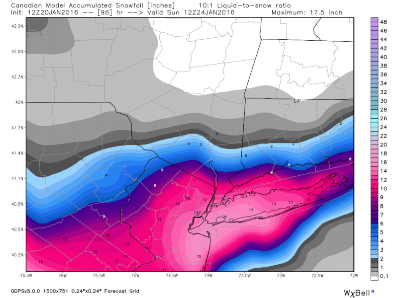
12z cmc snow map, but with possible issues do not worry about the SE movement. NYC, southern Westchester, NJ and LI still do very well, have been in the zone for all runs so far.

Last edited by jmanley32 on Wed Jan 20, 2016 11:48 am; edited 1 time in total

jmanley32- Senior Enthusiast

- Posts : 20648
Reputation : 108
Join date : 2013-12-12
Age : 43
Location : Yonkers, NY
 Re: 01/22/16 - 01/23/16 Update #3 - Will Models Trend Back North?
sroc4 wrote:Frank Rb do you guys not feel its possible that insted of CFI its actuallyt the redevelopment of a new LP center at the triple point in response to an occluded front via the original main LP center backing under the ULL??
Certainly possible. In fact, it's probably likely. But the other dynamics should override that for a while, I would think.
rb924119- Meteorologist

- Posts : 7117
Reputation : 195
Join date : 2013-02-06
Age : 32
Location : Greentown, Pa
 Re: 01/22/16 - 01/23/16 Update #3 - Will Models Trend Back North?
Have a question we were talking about how this storm could of possibly been historic is that off the table or is it still possible
Artechmetals- Pro Enthusiast

- Posts : 571
Reputation : 3
Join date : 2014-01-01
Age : 57
Location : Wayne , NJ
 Re: 01/22/16 - 01/23/16 Update #3 - Will Models Trend Back North?
Here's my issue with the CMC. The following maps depict 500 hPa heights and vorticity (energy), with what think should be going on based on the maps...
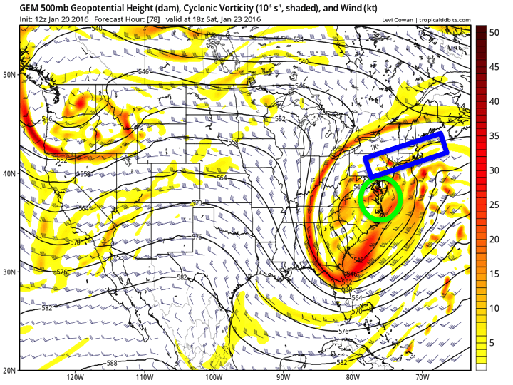
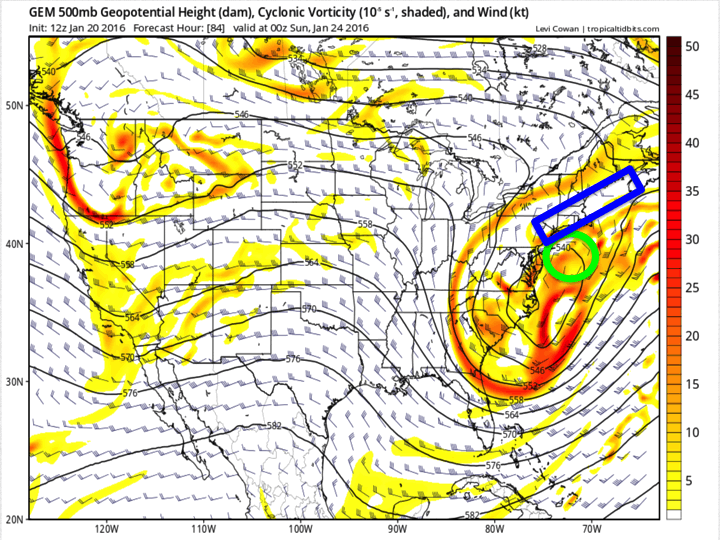
The green circle represents where I think the actual closed circulation should be based on the wind field, while the blue rectangle represents the area of best deformation, and forcing for the heaviest snows. This is what I think Frank is seeing too; the surface maps don't seem to be matching up with the synoptic (large-scale) areas of best ascent depicted in the mid- and upper-levels. It's almost like the surface is being disconnected from the other levels, and leading to the results we're seeing.


The green circle represents where I think the actual closed circulation should be based on the wind field, while the blue rectangle represents the area of best deformation, and forcing for the heaviest snows. This is what I think Frank is seeing too; the surface maps don't seem to be matching up with the synoptic (large-scale) areas of best ascent depicted in the mid- and upper-levels. It's almost like the surface is being disconnected from the other levels, and leading to the results we're seeing.
rb924119- Meteorologist

- Posts : 7117
Reputation : 195
Join date : 2013-02-06
Age : 32
Location : Greentown, Pa
 Re: 01/22/16 - 01/23/16 Update #3 - Will Models Trend Back North?
Artechmetals wrote:Have a question we were talking about how this storm could of possibly been historic is that off the table or is it still possible
DC is getting 25-35"
I'll say historic even if the higher amounts are not over our area. The NWS will surely rank this NESIS 4 or 5.
_________________
_______________________________________________________________________________________________________
CLICK HERE to view NJ Strong Snowstorm Classifications
 Re: 01/22/16 - 01/23/16 Update #3 - Will Models Trend Back North?
Artechmetals wrote:Have a question we were talking about how this storm could of possibly been historic is that off the table or is it still possible
It more than likely will be for mid atlantic vs our coverage area. Probably a MECS for us which is aight by me
_________________
"In weather and in life, there's no winning and losing; there's only winning and learning."
WINTER 2012/2013 TOTALS 43.65"WINTER 2017/2018 TOTALS 62.85" WINTER 2022/2023 TOTALS 4.9"
WINTER 2013/2014 TOTALS 64.85"WINTER 2018/2019 TOTALS 14.25" WINTER 2023/2024 TOTALS 13.1"
WINTER 2014/2015 TOTALS 71.20"WINTER 2019/2020 TOTALS 6.35" WINTER 2024/2025 TOTALS 0.00
WINTER 2015/2016 TOTALS 35.00"WINTER 2020/2021 TOTALS 37.75"
WINTER 2016/2017 TOTALS 42.25"WINTER 2021/2022 TOTALS 31.65"

sroc4- Admin

- Posts : 8463
Reputation : 302
Join date : 2013-01-07
Location : Wading River, LI
 Re: 01/22/16 - 01/23/16 Update #3 - Will Models Trend Back North?
Frank could those numbers move into our area or not likely

Artechmetals- Pro Enthusiast

- Posts : 571
Reputation : 3
Join date : 2014-01-01
Age : 57
Location : Wayne , NJ
 Re: 01/22/16 - 01/23/16 Update #3 - Will Models Trend Back North?
jmanley32 wrote:12z cmc snow map, but with possible issues do not worry about the SE movement. NYC, southern Westchester, NJ and LI still do very well, have been in the zone for all runs so far.
If you're in eastern orange county you are getting dizzy the last 48 hours. 3 inches, 12 inches, 24 inches 4 inches, 20 inches, 3 inches. That's why as Frank and others have said ignore the qpf for now. It does however appear pretty consistent that the HV especially 40 mile and up from NYC will be a battleground and sharp cuttoff somewhere. If I get another anti-virga storm I may lose it.

CPcantmeasuresnow- Wx Statistician Guru

- Posts : 7289
Reputation : 230
Join date : 2013-01-07
Age : 103
Location : Eastern Orange County, NY
 Re: 01/22/16 - 01/23/16 Update #3 - Will Models Trend Back North?
no chanceArtechmetals wrote:Frank could those numbers move into our area or not likely
 Re: 01/22/16 - 01/23/16 Update #3 - Will Models Trend Back North?
jmanley32 wrote:12z cmc snow map, but with possible issues do not worry about the SE movement. NYC, southern Westchester, NJ and LI still do very well, have been in the zone for all runs so far.
not sure what to think for NNJ or if i should not think about it at all if the QPF was screwy but that map so far has the lowest amount snow total up to date

RJB8525- Senior Enthusiast

- Posts : 1994
Reputation : 28
Join date : 2013-02-06
Age : 38
Location : Hackettstown, NJ
 Re: 01/22/16 - 01/23/16 Update #3 - Will Models Trend Back North?
cp hyde i will be happy with a 3-6 I know i want more who knows still got time but just something for my 2 Siberian Huskies to play around and of course me too!!!
jimv45- Senior Enthusiast

- Posts : 1168
Reputation : 36
Join date : 2013-09-20
Location : Hopewell jct.
 Re: 01/22/16 - 01/23/16 Update #3 - Will Models Trend Back North?
Jake don't worry about mixing we are in the jackpot let it play outjake732 wrote:no chanceArtechmetals wrote:Frank could those numbers move into our area or not likely

skinsfan1177- Senior Enthusiast

- Posts : 4485
Reputation : 35
Join date : 2013-01-07
Age : 47
Location : Point Pleasant Boro
 Re: 01/22/16 - 01/23/16 Update #3 - Will Models Trend Back North?
skinns ur in dream land im in reality land
 Re: 01/22/16 - 01/23/16 Update #3 - Will Models Trend Back North?
GFS ensembles are a non-event for us northern and western folks lol
rb924119- Meteorologist

- Posts : 7117
Reputation : 195
Join date : 2013-02-06
Age : 32
Location : Greentown, Pa
 Re: 01/22/16 - 01/23/16 Update #3 - Will Models Trend Back North?
jimv45 wrote:cp hyde i will be happy with a 3-6 I know i want more who knows still got time but just something for my 2 Siberian Huskies to play around and of course me too!!!
Jim, that's what I think we get in Dutchess county. You could get closer to 6 and I could get closer to 3. That's how sharp the precip cutoff will be.
hyde345- Pro Enthusiast

- Posts : 1084
Reputation : 48
Join date : 2013-01-08
Location : Hyde Park, NY
 Re: 01/22/16 - 01/23/16 Update #3 - Will Models Trend Back North?
Yea Rb still got time !! I am going to Hunter Mountain Sat with family so if we don't get much here at least I will get to see snow!!
jimv45- Senior Enthusiast

- Posts : 1168
Reputation : 36
Join date : 2013-09-20
Location : Hopewell jct.
 Re: 01/22/16 - 01/23/16 Update #3 - Will Models Trend Back North?
rb924119 wrote:GFS ensembles are a non-event for us northern and western folks lol

_________________
Mugs
AKA:King: Snow Weenie
Self Proclaimed
WINTER 2014-15 : 55.12" +.02 for 6 coatings (avg. 35")
WINTER 2015-16 Total - 29.8" (Avg 35")
WINTER 2016-17 : 39.5" so far

amugs- Advanced Forecaster - Mod

- Posts : 15157
Reputation : 213
Join date : 2013-01-07
Age : 54
Location : Hillsdale,NJ
 Re: 01/22/16 - 01/23/16 Update #3 - Will Models Trend Back North?
jake732 wrote:skinns ur in dream land im in reality land
Mixing is not likely to be an issue at this point. Should not supress any totals. Track is most important at this point boys
_________________
"In weather and in life, there's no winning and losing; there's only winning and learning."
WINTER 2012/2013 TOTALS 43.65"WINTER 2017/2018 TOTALS 62.85" WINTER 2022/2023 TOTALS 4.9"
WINTER 2013/2014 TOTALS 64.85"WINTER 2018/2019 TOTALS 14.25" WINTER 2023/2024 TOTALS 13.1"
WINTER 2014/2015 TOTALS 71.20"WINTER 2019/2020 TOTALS 6.35" WINTER 2024/2025 TOTALS 0.00
WINTER 2015/2016 TOTALS 35.00"WINTER 2020/2021 TOTALS 37.75"
WINTER 2016/2017 TOTALS 42.25"WINTER 2021/2022 TOTALS 31.65"

sroc4- Admin

- Posts : 8463
Reputation : 302
Join date : 2013-01-07
Location : Wading River, LI
 Re: 01/22/16 - 01/23/16 Update #3 - Will Models Trend Back North?
Yea hyde I think 3- 6 but lets get a big surprise and double that getting greedy!!!
jimv45- Senior Enthusiast

- Posts : 1168
Reputation : 36
Join date : 2013-09-20
Location : Hopewell jct.
 Re: 01/22/16 - 01/23/16 Update #3 - Will Models Trend Back North?
Where are you getting info bc it's not on here and these are the guys I listen toojake732 wrote:skinns ur in dream land im in reality land
Last edited by skinsfan1177 on Wed Jan 20, 2016 12:14 pm; edited 1 time in total

skinsfan1177- Senior Enthusiast

- Posts : 4485
Reputation : 35
Join date : 2013-01-07
Age : 47
Location : Point Pleasant Boro
 Re: 01/22/16 - 01/23/16 Update #3 - Will Models Trend Back North?
My personal opinion on Ensembles in this tight is like trying to look at something 6feet in front of you with Binoculars. Its time to put down the Binoculars and pick up the magify lense
Last edited by sroc4 on Wed Jan 20, 2016 12:14 pm; edited 1 time in total
_________________
"In weather and in life, there's no winning and losing; there's only winning and learning."
WINTER 2012/2013 TOTALS 43.65"WINTER 2017/2018 TOTALS 62.85" WINTER 2022/2023 TOTALS 4.9"
WINTER 2013/2014 TOTALS 64.85"WINTER 2018/2019 TOTALS 14.25" WINTER 2023/2024 TOTALS 13.1"
WINTER 2014/2015 TOTALS 71.20"WINTER 2019/2020 TOTALS 6.35" WINTER 2024/2025 TOTALS 0.00
WINTER 2015/2016 TOTALS 35.00"WINTER 2020/2021 TOTALS 37.75"
WINTER 2016/2017 TOTALS 42.25"WINTER 2021/2022 TOTALS 31.65"

sroc4- Admin

- Posts : 8463
Reputation : 302
Join date : 2013-01-07
Location : Wading River, LI
 Re: 01/22/16 - 01/23/16 Update #3 - Will Models Trend Back North?
rb924119 wrote:GFS ensembles are a non-event for us northern and western folks lol
I've been concerned with that from the beginning. There's a certain point north of the city that the heavy precip just cannot seem to penetrate. If it happens we root for everyone else in our area. However if DC and Baltimore get 25-35 and that seems likely from every run so far I will be ill.

CPcantmeasuresnow- Wx Statistician Guru

- Posts : 7289
Reputation : 230
Join date : 2013-01-07
Age : 103
Location : Eastern Orange County, NY
 Re: 01/22/16 - 01/23/16 Update #3 - Will Models Trend Back North?
CPcantmeasuresnow wrote:rb924119 wrote:GFS ensembles are a non-event for us northern and western folks lol
I've been concerned with that from the beginning. There's a certain point north of the city that the heavy precip just cannot seem to penetrate. If it happens we root for everyone else in our area. However if DC and Baltimore get 25-35 and that seems likely from every run so far I will be ill.
Euro will make a lot of people happy and kill off others IMO
nervous about this run lol

RJB8525- Senior Enthusiast

- Posts : 1994
Reputation : 28
Join date : 2013-02-06
Age : 38
Location : Hackettstown, NJ
 Re: 01/22/16 - 01/23/16 Update #3 - Will Models Trend Back North?
yea Cp that's the way its been Like I was saying I will take 3-6 at this point the heavy stuff stays south but it will be colder so we hope for something!
jimv45- Senior Enthusiast

- Posts : 1168
Reputation : 36
Join date : 2013-09-20
Location : Hopewell jct.
 Re: 01/22/16 - 01/23/16 Update #3 - Will Models Trend Back North?
Frank_Wx wrote:Artechmetals wrote:Have a question we were talking about how this storm could of possibly been historic is that off the table or is it still possible
DC is getting 25-35"
I'll say historic even if the higher amounts are not over our area. The NWS will surely rank this NESIS 4 or 5.
NESIS 4 or 5?
Scullybutcher- Pro Enthusiast

- Posts : 544
Reputation : 16
Join date : 2013-02-06
Location : North Smithtown, western Suffolk county, long island
Page 22 of 35 •  1 ... 12 ... 21, 22, 23 ... 28 ... 35
Page 22 of 35
Permissions in this forum:
You cannot reply to topics in this forum
 Home
Home