
 Search
Long Range Thread 12.0
Page 4 of 40 •  1, 2, 3, 4, 5 ... 22 ... 40
 ![]()
Re: Long Range Thread 12.0
![]() by amugs Wed Sep 07, 2016 8:34 am
by amugs Wed Sep 07, 2016 8:34 am
amugs- Advanced Forecaster - Mod

- Posts : 15157
Join date : 2013-01-07
Re: Long Range Thread 12.0
![]() by amugs Wed Sep 07, 2016 9:06 pm
by amugs Wed Sep 07, 2016 9:06 pm

And from the great meterological historian
UNC W
the neutral and weak la nina winters after an el nino are listed below...1978-79 was the only true neutral winter with an oni of 0.0 for DJF...1992-93 and 2003-04 never hit negative numbers...I'm leaning towards an oni of -0.9 or higher at its lowest point and maybe an official weak la nina...the three weak la nina's listed below the neutrals came after weak el nino's...1966 and 1983 and 1995 are the lead analogs as of now...
season...DJF ONI...
1959-60....-0.1
1966-67....-0.4
1978-79.....0.0
1980-81....-0.2
1983-84....-0.5
1992-93.....0.2
2003-04.....0.3
2005-06....-0.7
...............................................................................................
1954-55....-0.6
1964-65....-0.5
1995-96.[[/b]...-0.9
amugs- Advanced Forecaster - Mod
- Posts : 15157
Join date : 2013-01-07
Re: Long Range Thread 12.0
![]() by amugs Wed Sep 07, 2016 9:13 pm
by amugs Wed Sep 07, 2016 9:13 pm
_________________
Mugs
AKA:King: Snow Weenie
Self Proclaimed
WINTER 2014-15 : 55.12" +.02 for 6 coatings (avg. 35")
WINTER 2015-16 Total - 29.8" (Avg 35")
WINTER 2016-17 : 39.5" so far

amugs- Advanced Forecaster - Mod
- Posts : 15157
Reputation : 213
Join date : 2013-01-07
Age : 54
Location : Hillsdale,NJ
Re: Long Range Thread 12.0
![]() by nutleyblizzard Wed Sep 07, 2016 9:28 pm
by nutleyblizzard Wed Sep 07, 2016 9:28 pm

nutleyblizzard- Senior Enthusiast

- Posts : 1964
Reputation : 41
Join date : 2014-01-30
Age : 58
Location : Nutley, new jersey
Re: Long Range Thread 12.0
![]() by amugs Wed Sep 07, 2016 10:04 pm
by amugs Wed Sep 07, 2016 10:04 pm
1.2 is positive
3 slight neg
3.4 negative
4 neutral
http://www.cpc.ncep.noaa.gov/data/indices/wksst8110.for
_________________
Mugs
AKA:King: Snow Weenie
Self Proclaimed
WINTER 2014-15 : 55.12" +.02 for 6 coatings (avg. 35")
WINTER 2015-16 Total - 29.8" (Avg 35")
WINTER 2016-17 : 39.5" so far
amugs- Advanced Forecaster - Mod
- Posts : 15157
Reputation : 213
Join date : 2013-01-07
Age : 54
Location : Hillsdale,NJ
Re: Long Range Thread 12.0
![]() by nutleyblizzard Thu Sep 08, 2016 11:33 am
by nutleyblizzard Thu Sep 08, 2016 11:33 am
nutleyblizzard- Senior Enthusiast
- Posts : 1964
Reputation : 41
Join date : 2014-01-30
Age : 58
Location : Nutley, new jersey
Re: Long Range Thread 12.0
![]() by frank 638 Thu Sep 08, 2016 1:58 pm
by frank 638 Thu Sep 08, 2016 1:58 pm
frank 638- Senior Enthusiast
- Posts : 2882
Reputation : 37
Join date : 2016-01-01
Age : 41
Location : bronx ny
Re: Long Range Thread 12.0
![]() by nutleyblizzard Thu Sep 08, 2016 2:52 pm
by nutleyblizzard Thu Sep 08, 2016 2:52 pm
When there is a neutral ENSO present, all that means is that feature will not be the driving force of our winter. We are then dependent on other features to decide our fate. The PDO, AO, NAO, EPO, and to an extent the QBO come into play. The more of those that work in our favor, the better chance to have a great winter. As of now we may very well have most if not all of them on our side. I'm tempering my excitement for now, after all its only September.frank 638 wrote:Meaning to a above average snowfall I hope
nutleyblizzard- Senior Enthusiast
- Posts : 1964
Reputation : 41
Join date : 2014-01-30
Age : 58
Location : Nutley, new jersey
Re: Long Range Thread 12.0
![]() by amugs Thu Sep 08, 2016 3:11 pm
by amugs Thu Sep 08, 2016 3:11 pm
nutleyblizzard wrote:When there is a neutral ENSO present, all that means is that feature will not be the driving force of our winter. We are then dependent on other features to decide our fate. The PDO, AO, NAO, EPO, and to an extent the QBO come into play. The more of those that work in our favor, the better chance to have a great winter. As of now we may very well have most if not all of them on our side. I'm tempering my excitement for now, after all its only September.frank 638 wrote:Meaning to a above average snowfall I hope
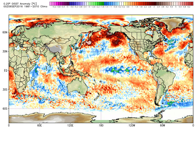
We are having an El Nino hangover and there is still good warmth in the Pac and the IOD is cool very cool like as Sroc showed in 14-15 - so what is now in our favor:
PDO is Positive and the warm blob in the GOA will/should prodcue an EPO Negative
QBO is Positive from what I see
2015 -26.70 -28.62 -28.15 -24.38 -12.33 2.18 7.45 10.97 12.07 13.38 12.79 11.39
2016 9.34 6.77 3.16 0.64 2.37 3.86 6.25 10.07
I personally think we are in a La Nina weak state as we head into winter
Solar low as evidence in this chart

We shall see
_________________
Mugs
AKA:King: Snow Weenie
Self Proclaimed
WINTER 2014-15 : 55.12" +.02 for 6 coatings (avg. 35")
WINTER 2015-16 Total - 29.8" (Avg 35")
WINTER 2016-17 : 39.5" so far
amugs- Advanced Forecaster - Mod
- Posts : 15157
Reputation : 213
Join date : 2013-01-07
Age : 54
Location : Hillsdale,NJ
Re: Long Range Thread 12.0
![]() by NjWeatherGuy Thu Sep 08, 2016 8:27 pm
by NjWeatherGuy Thu Sep 08, 2016 8:27 pm
http://www.cpc.ncep.noaa.gov/products/analysis_monitoring/enso_advisory/figure7.gif
As you can see, we are in a weak Nina state at the moment, and will likely remain here and creep up towards neutral as we head into fall and winter, towards the end of winter, may actually hit winter or technically become a weak Nino, but again, basically neutral.

NjWeatherGuy- Advanced Forecaster

- Posts : 4100
Reputation : 28
Join date : 2013-01-06
Location : Belle Mead, NJ
Re: Long Range Thread 12.0
![]() by amugs Thu Sep 08, 2016 10:20 pm
by amugs Thu Sep 08, 2016 10:20 pm
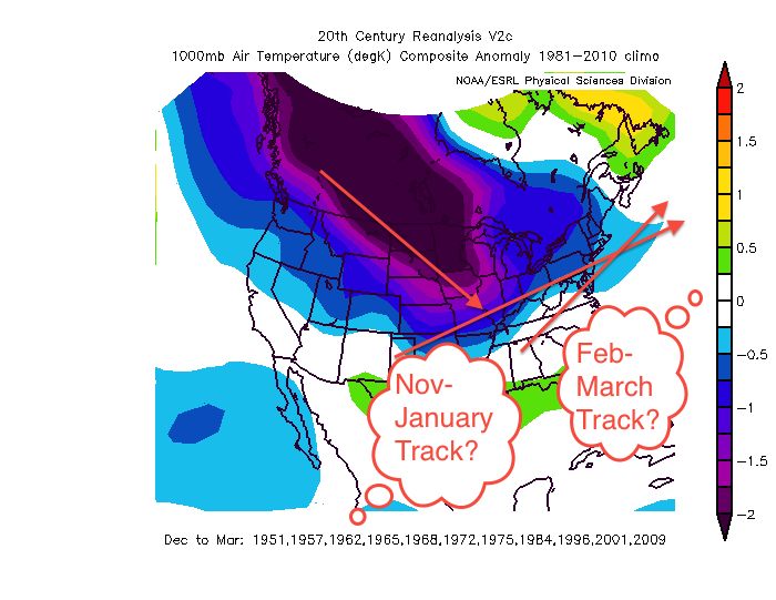
A good look at this range.
JB wrote up it had the same kind of look in 2013 bit more so 2014 and u need to push the cold east with the warm PDO and GOA argues for a protracted block on both sides from the sst, we like.blocky pattens over the pac and more so over the atlantic this remains to be seen

NAO block look
_________________
Mugs
AKA:King: Snow Weenie
Self Proclaimed
WINTER 2014-15 : 55.12" +.02 for 6 coatings (avg. 35")
WINTER 2015-16 Total - 29.8" (Avg 35")
WINTER 2016-17 : 39.5" so far
amugs- Advanced Forecaster - Mod
- Posts : 15157
Reputation : 213
Join date : 2013-01-07
Age : 54
Location : Hillsdale,NJ
Re: Long Range Thread 12.0
![]() by sroc4 Fri Sep 09, 2016 9:05 am
by sroc4 Fri Sep 09, 2016 9:05 am
nutleyblizzard wrote:https://twitter.com/NWS/status/773870561151758336 It's looking more likely folks we're going to have neutral ENSO conditions this winter.
I really find this interesting. I'm not sure I'm sold on this idea of La Nina cancel just yet. If I have some time I may try to elaborate as to why.
_________________
"In weather and in life, there's no winning and losing; there's only winning and learning."
WINTER 2012/2013 TOTALS 43.65"WINTER 2017/2018 TOTALS 62.85" WINTER 2022/2023 TOTALS 4.9"
WINTER 2013/2014 TOTALS 64.85"WINTER 2018/2019 TOTALS 14.25" WINTER 2023/2024 TOTALS 13.1"
WINTER 2014/2015 TOTALS 71.20"WINTER 2019/2020 TOTALS 6.35" WINTER 2024/2025 TOTALS 0.00
WINTER 2015/2016 TOTALS 35.00"WINTER 2020/2021 TOTALS 37.75"
WINTER 2016/2017 TOTALS 42.25"WINTER 2021/2022 TOTALS 31.65"

sroc4- Admin

- Posts : 8458
Reputation : 302
Join date : 2013-01-07
Location : Wading River, LI
Re: Long Range Thread 12.0
![]() by amugs Sun Sep 11, 2016 9:04 am
by amugs Sun Sep 11, 2016 9:04 am
_________________
Mugs
AKA:King: Snow Weenie
Self Proclaimed
WINTER 2014-15 : 55.12" +.02 for 6 coatings (avg. 35")
WINTER 2015-16 Total - 29.8" (Avg 35")
WINTER 2016-17 : 39.5" so far
amugs- Advanced Forecaster - Mod
- Posts : 15157
Reputation : 213
Join date : 2013-01-07
Age : 54
Location : Hillsdale,NJ
Re: Long Range Thread 12.0
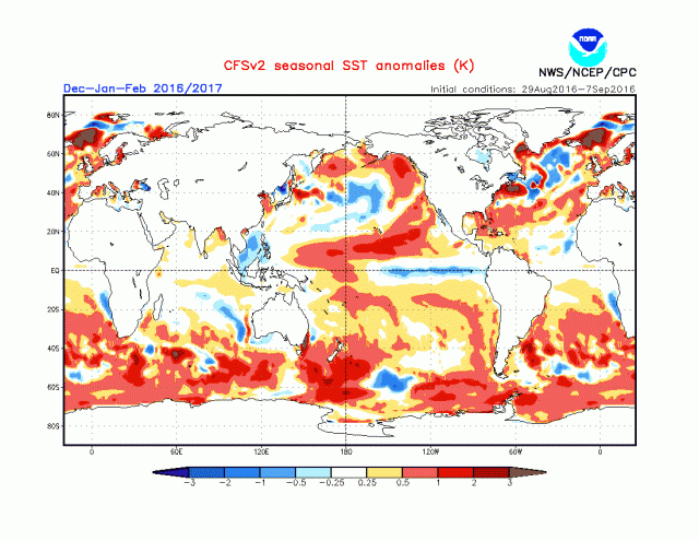
![]() by amugs Sun Sep 11, 2016 3:50 pm
by amugs Sun Sep 11, 2016 3:50 pm
.gif)
.gif)
CFSv2 has gone from this
.gif)
to this
.gif)
It is starting to ingest the BLOB and PDO warmth in the PAC
_________________
Mugs
AKA:King: Snow Weenie
Self Proclaimed
WINTER 2014-15 : 55.12" +.02 for 6 coatings (avg. 35")
WINTER 2015-16 Total - 29.8" (Avg 35")
WINTER 2016-17 : 39.5" so far
amugs- Advanced Forecaster - Mod
- Posts : 15157
Reputation : 213
Join date : 2013-01-07
Age : 54
Location : Hillsdale,NJ
Re: Long Range Thread 12.0
![]() by nutleyblizzard Sun Sep 11, 2016 4:20 pm
by nutleyblizzard Sun Sep 11, 2016 4:20 pm
nutleyblizzard- Senior Enthusiast
- Posts : 1964
Reputation : 41
Join date : 2014-01-30
Age : 58
Location : Nutley, new jersey
Re: Long Range Thread 12.0
![]() by sroc4 Sun Sep 11, 2016 6:37 pm
by sroc4 Sun Sep 11, 2016 6:37 pm
amugs wrote:From JB A slight CHANGE IN Nina - NWS/NOAA may have jumped the gun
CFSv2 has gone from this
to this
It is starting to ingest the BLOB and PDO warmth in the PAC
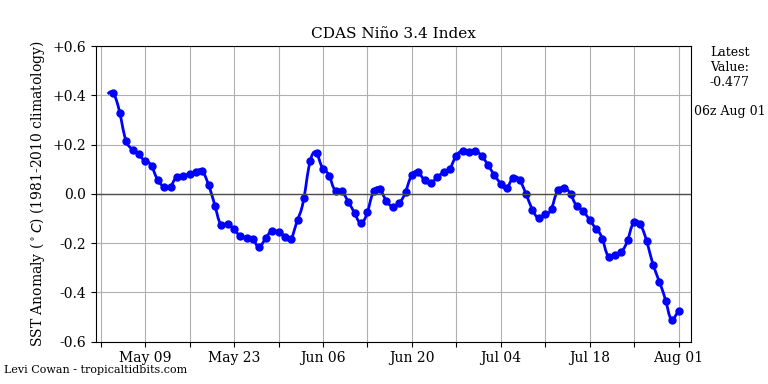
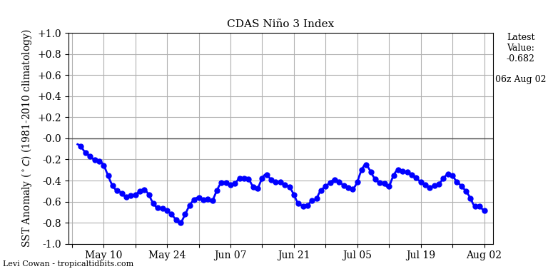
That and the fact that the ONI sits at -0.3 with the month of sept looking to bring the SOI running means close to +8.0. Although sub surface temps have cooled some over the last two months they are still cool.
_________________
"In weather and in life, there's no winning and losing; there's only winning and learning."
WINTER 2012/2013 TOTALS 43.65"WINTER 2017/2018 TOTALS 62.85" WINTER 2022/2023 TOTALS 4.9"
WINTER 2013/2014 TOTALS 64.85"WINTER 2018/2019 TOTALS 14.25" WINTER 2023/2024 TOTALS 13.1"
WINTER 2014/2015 TOTALS 71.20"WINTER 2019/2020 TOTALS 6.35" WINTER 2024/2025 TOTALS 0.00
WINTER 2015/2016 TOTALS 35.00"WINTER 2020/2021 TOTALS 37.75"
WINTER 2016/2017 TOTALS 42.25"WINTER 2021/2022 TOTALS 31.65"
sroc4- Admin
- Posts : 8458
Reputation : 302
Join date : 2013-01-07
Location : Wading River, LI
Re: Long Range Thread 12.0
![]() by sroc4 Mon Sep 12, 2016 9:18 am
by sroc4 Mon Sep 12, 2016 9:18 am
SOI values for 12 Sep 2016
Average for last 30 days
8.21
Average for last 90 days
5.36
Daily contribution to SOI calculation
18.25
https://www.longpaddock.qld.gov.au/seasonalclimateoutlook/southernoscillationindex/30daysoivalues/
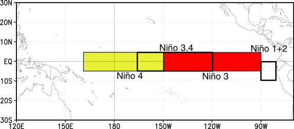
Nino 3.4 & 3
Nino 1.2 & 4


On Avg the ONI value has dropped by 0.4-0.6 over the last 5 months. If that trend continues then after Sept the ONI will be below -0.5 which in part characterizes a La Nina conditions. Oceanic Niño Index (ONI) (3 month running mean SST anomalies in the Niño 3.4 region)
_________________
"In weather and in life, there's no winning and losing; there's only winning and learning."
WINTER 2012/2013 TOTALS 43.65"WINTER 2017/2018 TOTALS 62.85" WINTER 2022/2023 TOTALS 4.9"
WINTER 2013/2014 TOTALS 64.85"WINTER 2018/2019 TOTALS 14.25" WINTER 2023/2024 TOTALS 13.1"
WINTER 2014/2015 TOTALS 71.20"WINTER 2019/2020 TOTALS 6.35" WINTER 2024/2025 TOTALS 0.00
WINTER 2015/2016 TOTALS 35.00"WINTER 2020/2021 TOTALS 37.75"
WINTER 2016/2017 TOTALS 42.25"WINTER 2021/2022 TOTALS 31.65"
sroc4- Admin
- Posts : 8458
Reputation : 302
Join date : 2013-01-07
Location : Wading River, LI
Re: Long Range Thread 12.0
![]() by amugs Mon Sep 12, 2016 2:29 pm
by amugs Mon Sep 12, 2016 2:29 pm
Latest #'s 1.2 3 3.4 4
03AUG2016 21.5 0.5 24.7-0.5 26.4-0.5 28.8 0.1
10AUG2016 21.0 0.1 24.5-0.7 26.3-0.6 28.6-0.1
17AUG2016 21.1 0.5 24.5-0.5 26.3-0.5 28.7 0.0
24AUG2016 20.8 0.2 24.4-0.5 26.2-0.6 28.6-0.1
31AUG2016 20.9 0.3 24.6-0.3 26.0-0.7 28.5-0.1
07SEP2016 20.8 0.3 24.6-0.3 26.1-0.7 28.6-0.1

_________________
Mugs
AKA:King: Snow Weenie
Self Proclaimed
WINTER 2014-15 : 55.12" +.02 for 6 coatings (avg. 35")
WINTER 2015-16 Total - 29.8" (Avg 35")
WINTER 2016-17 : 39.5" so far
amugs- Advanced Forecaster - Mod
- Posts : 15157
Reputation : 213
Join date : 2013-01-07
Age : 54
Location : Hillsdale,NJ
Re: Long Range Thread 12.0
![]() by amugs Mon Sep 12, 2016 3:20 pm
by amugs Mon Sep 12, 2016 3:20 pm

_________________
Mugs
AKA:King: Snow Weenie
Self Proclaimed
WINTER 2014-15 : 55.12" +.02 for 6 coatings (avg. 35")
WINTER 2015-16 Total - 29.8" (Avg 35")
WINTER 2016-17 : 39.5" so far
amugs- Advanced Forecaster - Mod
- Posts : 15157
Reputation : 213
Join date : 2013-01-07
Age : 54
Location : Hillsdale,NJ
Re: Long Range Thread 12.0
![]() by Frank_Wx Mon Sep 12, 2016 9:08 pm
by Frank_Wx Mon Sep 12, 2016 9:08 pm
sroc4 wrote:SOI rise continues which is going to cont to cause cooling in the Trop Pac:
SOI values for 12 Sep 2016
Average for last 30 days
8.21
Average for last 90 days
5.36
Daily contribution to SOI calculation
18.25
https://www.longpaddock.qld.gov.au/seasonalclimateoutlook/southernoscillationindex/30daysoivalues/
Nino 3.4 & 3
Nino 1.2 & 4
On Avg the ONI value has dropped by 0.4-0.6 over the last 5 months. If that trend continues then after Sept the ONI will be below -0.5 which in part characterizes a La Nina conditions. Oceanic Niño Index (ONI) (3 month running mean SST anomalies in the Niño 3.4 region)
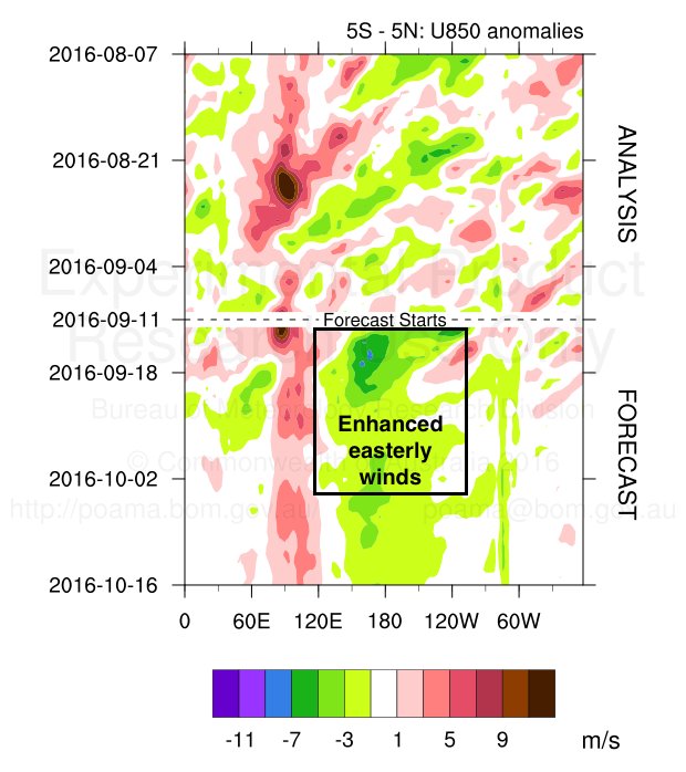
Easterly winds at the Dateline are expected to take off in a week and last into October. This should especially jumpstart La Nina.
_________________
_______________________________________________________________________________________________________
CLICK HERE to view NJ Strong Snowstorm Classifications

Frank_Wx- Godzilla Seeker
- Posts : 21325
Reputation : 328
Join date : 2013-01-05
Age : 32
Location : Jersey City, NJ -

Re: Long Range Thread 12.0
![]() by track17 Mon Sep 12, 2016 9:22 pm
by track17 Mon Sep 12, 2016 9:22 pm
track17- Posts : 454
Reputation : 4
Join date : 2016-01-09
Re: Long Range Thread 12.0
![]() by Frank_Wx Mon Sep 12, 2016 9:49 pm
by Frank_Wx Mon Sep 12, 2016 9:49 pm
1) The behaviour of the QBO this summer has been interesting. Westerly winds were very strong winter 2015-2016. If you recall, the Stratospheric PV was anomalous and even though it battled a couple of warming events it remained very stubborn over the Pole. Westerly winds at 30mb remain pretty strong (not to the extent of this past winter though) and this has cut-off the downward propagation of easterly winds. According to Holton & Tan, SSWE are more likely to occur when the QBO is in an easterly phase and the stubbornness of the QBO to stay westerly to this point is worth noting.
2) 850mb wind anomalies are forecasted to bring strong easterly winds to the Dateline. This event will begin later this weekend and last into the beginning of October. There is a good chance this jump starts La Nina and helps cool temps fairly rapidly at ENSO 3.4 region. I would expect a weak La Nina to form despite the hesitancy some dynamical models are showing. We're exiting one of the strongest El Nino episodes on record. Historically, the Equatorial Pacific balances itself out by following up with a La Nina event. NOAA actually removed the ENSO watch and dropped chances of La Nina to form to 40%. The next update is not until October 14th. If this surge of easterly winds does not cool the Tropical Pac, then we're likely to see ENSO-Neutral conditions this winter.
3. Sea surface temps in the northern Pacific are warm. The warm "blob" has returned and it does not show signs of letting up. Granted it's still very early before we get to Meteorological winter, but I would think if La Nina does begin to come on strong then that could detract some of the warming in the NPAC. Regardless, we're still in a +PDO phase and that should not chance as we head into winter. So, expect warmer than normal SST's off the west coast and toward the north-central PAC this winter. How anomalous the warmth is will determine whether or not we see strong -EPO/+PNA episodes to help counteract the +NAO (yes, I do not like the prospects of a -NAO this winter but still early). Meanwhile, SST's in the northern Atlantic have been on a cooling trend the last 10 days, but overall they've warmed significantly since the winter and it will be interesting to see if SST's remain above normal off our coast.
4. Solar activity is on the decline and we're headed to our minimum in the year 2020. The relationship between the QBO and solar cycle is an interesting one and I'll look to uncover additional detail by the time my winter outlook comes out.
Lots more to come...
_________________
_______________________________________________________________________________________________________
CLICK HERE to view NJ Strong Snowstorm Classifications
Frank_Wx- Godzilla Seeker
- Posts : 21325
Reputation : 328
Join date : 2013-01-05
Age : 32
Location : Jersey City, NJ -
Re: Long Range Thread 12.0
![]() by Isotherm Mon Sep 12, 2016 11:45 pm
by Isotherm Mon Sep 12, 2016 11:45 pm
I do notice cooling in the Indian Ocean recently; that will be interesting to track insofar as CCKWs, MJO and tropical forcing propagation. We'll probably have more classic Nina forcing this year, even if we don't manage to officially cross the weak Nina threshold.
I posted last month that I didn't like the early signals for a -NAO winter either. As you noted, there are other factors to examine as the autumn progresses, so this can change. There are some smoke and mirror correlations associated with NAO forecasting as well, and I think some of those have become more evident over recent autumns.
The QBO is in uncharted territory, so it's difficult to assert whether it'll normalize over the coming months or not. The extreme burst of westerly momentum via the troposphere probably induced by the super Nino event ended up decelerating the downwelling stratospheric easterlies. In any event, yes, the interplay of the QBO/Solar activity is something I monitor too. There are sometimes aberrations; however, due to other exogenous variables, which can either promote less or more blocking than expected.
If I was forced to make a call right now, it would be poleward Aleutian ridge in conjunction with a stronger than average polar vortex, yielding a cold Rockies/Mid-west and tight gradient across the Northeast with areas further north performing better cold/snow wise.
Isotherm- Advanced Forecaster
- Posts : 231
Reputation : 4
Join date : 2014-09-01
Age : 34
Location : Monmouth County, NJ -
Re: Long Range Thread 12.0
![]() by sroc4 Tue Sep 13, 2016 9:58 am
by sroc4 Tue Sep 13, 2016 9:58 am
track17 wrote:Can someone translate this. Does this mean we are going to have a bad winter now with little snow? Please explain
Track...These statements alone cannot be translated yet into what it means for our upcoming winter. In general when you see the SOI increase as it is currently, and forecast to do over most of the this month it typicaly means a stronger easterly(coming from the east moving west) component to the winds over the Tropical Pac. Picture the Tropical Pac like a big bath tub with the western side where the warm water is running. In general the western Trop Pac has warmer water temps than the eastern half.

Now picture you have a giant Fan blowing over the surface of the bathtub(Trop Pac). If the Fan is placed on the western side (westerly winds) faceing east towards the Americas then you might visualize the warmer waters being pushed east. If those westerly winds persist long enough(which will often times be seen when the SOI is strongly negative) and strong enough, then the warmer western Pac ends up mixing with the cooler waters to the east warming them to above normal temps relative to average....El Nino conditions. Currently the SOi is such that Easterly winds are predicted to be anomalously strong over the next month. Place the Fan on the eatern side of the Pac and push the warmer waters back west and aloww the cooler sub surface waters to rise to replace the water being pushed west cooling the Trop Pac...La Nina conditions. Of course this is very simply put but the overall idea is there.
In general the Trop Pac, because its such a huge body of water relative to the rest of the globe, plays one of the most important roles in setting up the pattern going into winter months; however, its not the only piece to the puzzle. This discussion is simply monitoring one parameter that will influence the outcome of the winter. Patience for now is needed as we still have a few more months to see where all the different drivers to the weather system, Trop Pacific, indian ocean, Northern Pac, Atlantic SST, snow cover in Siberia, stratosphere to name but a few) set up before making predictions on how the winter unfolds in a specific region.
_________________
"In weather and in life, there's no winning and losing; there's only winning and learning."
WINTER 2012/2013 TOTALS 43.65"WINTER 2017/2018 TOTALS 62.85" WINTER 2022/2023 TOTALS 4.9"
WINTER 2013/2014 TOTALS 64.85"WINTER 2018/2019 TOTALS 14.25" WINTER 2023/2024 TOTALS 13.1"
WINTER 2014/2015 TOTALS 71.20"WINTER 2019/2020 TOTALS 6.35" WINTER 2024/2025 TOTALS 0.00
WINTER 2015/2016 TOTALS 35.00"WINTER 2020/2021 TOTALS 37.75"
WINTER 2016/2017 TOTALS 42.25"WINTER 2021/2022 TOTALS 31.65"
sroc4- Admin
- Posts : 8458
Reputation : 302
Join date : 2013-01-07
Location : Wading River, LI
Re: Long Range Thread 12.0
![]() by amugs Tue Sep 13, 2016 5:31 pm
by amugs Tue Sep 13, 2016 5:31 pm
Will post official forecast come Oct if any changes need to be made
Temps - D-M
Precip

Where do I sign????
_________________
Mugs
AKA:King: Snow Weenie
Self Proclaimed
WINTER 2014-15 : 55.12" +.02 for 6 coatings (avg. 35")
WINTER 2015-16 Total - 29.8" (Avg 35")
WINTER 2016-17 : 39.5" so far
amugs- Advanced Forecaster - Mod
- Posts : 15157
Reputation : 213
Join date : 2013-01-07
Age : 54
Location : Hillsdale,NJ
Re: Long Range Thread 12.0
![]() by NjWeatherGuy Tue Sep 13, 2016 5:48 pm
by NjWeatherGuy Tue Sep 13, 2016 5:48 pm
NjWeatherGuy- Advanced Forecaster
- Posts : 4100
Reputation : 28
Join date : 2013-01-06
Location : Belle Mead, NJ
Re: Long Range Thread 12.0
![]() by amugs Tue Sep 13, 2016 7:55 pm
by amugs Tue Sep 13, 2016 7:55 pm

Look st the subsurface - not that cool
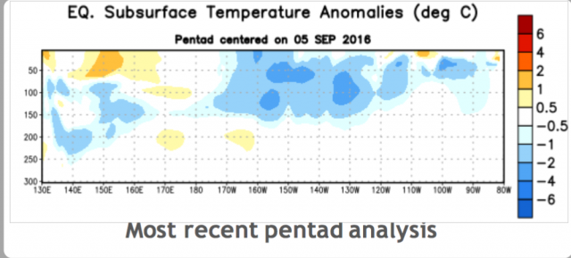
This is subsiding by my eye and the SOI is I would say in response to some other weather event - read that seasonal pressure changes in this SPAC region ten to cause these Rosby Waves to occur - could be wrong but time will tell.
Lets compare this years blob
currrent
.png)
to 2014-15 Winter season
.png)
Lets hope it holds and deepens as we move through the fall - no upwelling by recurving typhoons please!!
JB posted this 500mb CFSv2
.png)
_________________
Mugs
AKA:King: Snow Weenie
Self Proclaimed
WINTER 2014-15 : 55.12" +.02 for 6 coatings (avg. 35")
WINTER 2015-16 Total - 29.8" (Avg 35")
WINTER 2016-17 : 39.5" so far
amugs- Advanced Forecaster - Mod
- Posts : 15157
Reputation : 213
Join date : 2013-01-07
Age : 54
Location : Hillsdale,NJ
Page 4 of 40 • 1, 2, 3, 4, 5 ... 22 ... 40 ![]()