Long Range Thread 16.0
+44
snowday111
HectorO
Grselig
essexcountypete
Snow88
mwilli5783
WeatherBob
NjWeatherGuy
Dunnzoo
jake732
aiannone
crippo84
bobjohnsonforthehall
Scullybutcher
algae888
dsix85
dkodgis
sroc4
emokid51783
Math23x7
Sanchize06
docstox12
billg315
oldtimer
CPcantmeasuresnow
skinsfan1177
Quietace
SENJsnowman
lglickman1
hyde345
MattyICE
Carter bk
RJB8525
jimv45
amugs
GreyBeard
weatherwatchermom
SoulSingMG
nutleyblizzard
mikeypizano
rb924119
frank 638
jmanley32
Frank_Wx
48 posters
Page 28 of 40
Page 28 of 40 •  1 ... 15 ... 27, 28, 29 ... 34 ... 40
 Re: Long Range Thread 16.0
Basically Ukie, Euro, EPS, RGEM, CMC have thisbticking west as all of our seasonal trends have gine. The 1st wave amplifies and when it does it will strengthen the WAR and push this sicker west that is the coa st al. We have two storms the lier and then the coastal. We want the clipper to amplify so it strengthens the Ar.
Now some EPS individual members have that amplifing to the degree where it stalls the storm off the NJ coast which would cause a sharp cut off N& w and the city again. If kle set up but very intruining and exciting at the same time.
Off to my sons hi key game check back after the game peeps.
Great trends at h5 today.
amugs- Advanced Forecaster - Mod

- Posts : 15150
Join date : 2013-01-07
 Re: Long Range Thread 16.0
Like I mentioned earlier the 12zNAM and euro close off H5 whereas the rest do not. 18z NAM just went to the progressive soln. As seen by the stronger kicker knocking down the PNA ridge. I would not count on wave 2 as the pattern just simple does not call for it. This would be for wed to Thursday. It’s not impossible but not likely. IMO
sroc4- Admin

- Posts : 8458
Join date : 2013-01-07
 Re: Long Range Thread 16.0
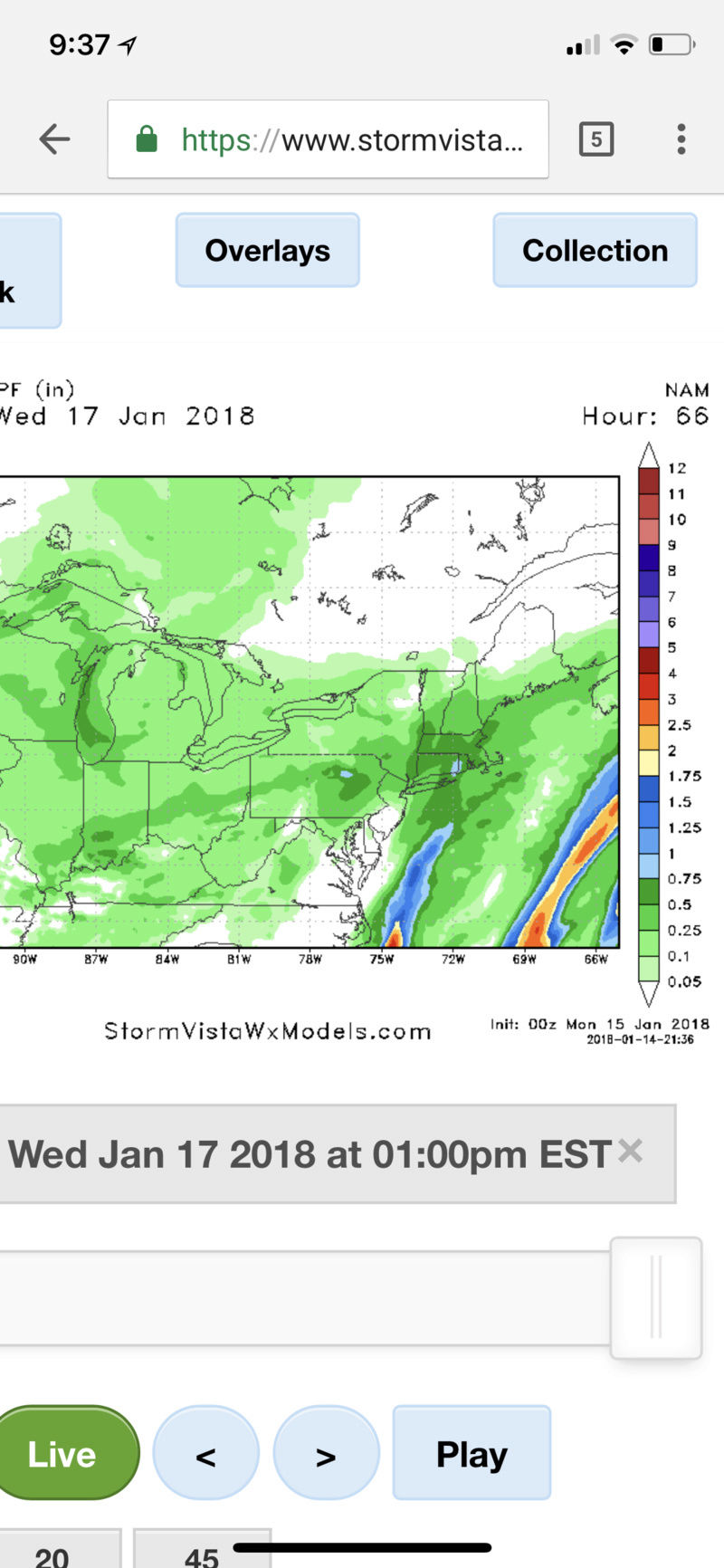
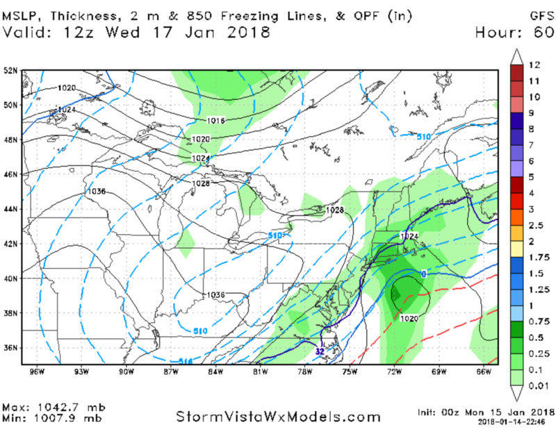
18z GFS is wetter and further west with the coastal low
_________________
-Alex Iannone-

aiannone- Senior Enthusiast - Mod

- Posts : 4828
Reputation : 92
Join date : 2013-01-07
Location : Saint James, LI (Northwest Suffolk Co.)
 Re: Long Range Thread 16.0
aiannone wrote:18z GFS is wetter and further west with the coastal low
Still looks like only a 1-3” event though right?

billg315- Advanced Forecaster - Mod

- Posts : 4562
Reputation : 185
Join date : 2015-01-24
Age : 50
Location : Flemington, NJ
 Re: Long Range Thread 16.0
This type of set-up never seems to deliver much for this area so I can’t see us doing more than a couple inches on this.

billg315- Advanced Forecaster - Mod

- Posts : 4562
Reputation : 185
Join date : 2015-01-24
Age : 50
Location : Flemington, NJ
 Re: Long Range Thread 16.0
Cover the ground I’ll be happy
Scullybutcher- Pro Enthusiast

- Posts : 544
Reputation : 16
Join date : 2013-02-06
Location : North Smithtown, western Suffolk county, long island
 Re: Long Range Thread 16.0
There are two possible events. The first one is for later Tuesday into very early Wed. This is from a gradient type set up with weak surface LP forming along a frontal boundary just south of us. This event looks likely to me but is going to be a light event with mostly a C-2”Maybe some eastern section might see max 3-4” if there is any enhancement with the Atlantic Ocean. Temps will be marginal along the coast and this system is moving fast so we’ll see.
The second event would be for late wed into Thursday. This will only happen for us if the flow slows down and we can get the energy to consolidate in the base of the trough. I have outlined what likely needs to happen ie 500mb close off which only happens if the kicker trends weaker in the west which prevents the flattening of the PNa ridge. Unfort this looks highly unlikely to me but I won’t put this to bed just yet. Even though the 18z looked wetter on the surface the H5 still was very positively tilted and fast moving
The second event would be for late wed into Thursday. This will only happen for us if the flow slows down and we can get the energy to consolidate in the base of the trough. I have outlined what likely needs to happen ie 500mb close off which only happens if the kicker trends weaker in the west which prevents the flattening of the PNa ridge. Unfort this looks highly unlikely to me but I won’t put this to bed just yet. Even though the 18z looked wetter on the surface the H5 still was very positively tilted and fast moving
_________________
"In weather and in life, there's no winning and losing; there's only winning and learning."
WINTER 2012/2013 TOTALS 43.65"WINTER 2017/2018 TOTALS 62.85" WINTER 2022/2023 TOTALS 4.9"
WINTER 2013/2014 TOTALS 64.85"WINTER 2018/2019 TOTALS 14.25" WINTER 2023/2024 TOTALS 13.1"
WINTER 2014/2015 TOTALS 71.20"WINTER 2019/2020 TOTALS 6.35" WINTER 2024/2025 TOTALS 0.00
WINTER 2015/2016 TOTALS 35.00"WINTER 2020/2021 TOTALS 37.75"
WINTER 2016/2017 TOTALS 42.25"WINTER 2021/2022 TOTALS 31.65"

sroc4- Admin

- Posts : 8458
Reputation : 302
Join date : 2013-01-07
Location : Wading River, LI

aiannone- Senior Enthusiast - Mod

- Posts : 4828
Reputation : 92
Join date : 2013-01-07
Location : Saint James, LI (Northwest Suffolk Co.)

aiannone- Senior Enthusiast - Mod

- Posts : 4828
Reputation : 92
Join date : 2013-01-07
Location : Saint James, LI (Northwest Suffolk Co.)
 Re: Long Range Thread 16.0
HV gets a good storm on this as does Ct.
Bobby M maps
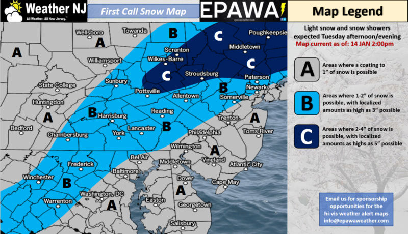
Bobby M maps

_________________
Mugs
AKA:King: Snow Weenie
Self Proclaimed
WINTER 2014-15 : 55.12" +.02 for 6 coatings (avg. 35")
WINTER 2015-16 Total - 29.8" (Avg 35")
WINTER 2016-17 : 39.5" so far

amugs- Advanced Forecaster - Mod

- Posts : 15150
Reputation : 213
Join date : 2013-01-07
Age : 54
Location : Hillsdale,NJ
 Re: Long Range Thread 16.0
12K NAM


_________________
Mugs
AKA:King: Snow Weenie
Self Proclaimed
WINTER 2014-15 : 55.12" +.02 for 6 coatings (avg. 35")
WINTER 2015-16 Total - 29.8" (Avg 35")
WINTER 2016-17 : 39.5" so far

amugs- Advanced Forecaster - Mod

- Posts : 15150
Reputation : 213
Join date : 2013-01-07
Age : 54
Location : Hillsdale,NJ
 Re: Long Range Thread 16.0
Models look warm for the immediate coast at the sfc, but coming out of this arctic airmass with snow falling, should keep temps cold enough
_________________
-Alex Iannone-

aiannone- Senior Enthusiast - Mod

- Posts : 4828
Reputation : 92
Join date : 2013-01-07
Location : Saint James, LI (Northwest Suffolk Co.)

aiannone- Senior Enthusiast - Mod

- Posts : 4828
Reputation : 92
Join date : 2013-01-07
Location : Saint James, LI (Northwest Suffolk Co.)
 Re: Long Range Thread 16.0
aiannone wrote:0z GFS!
Only a Long Island guy could be excited about this model. Lol. ;-)

billg315- Advanced Forecaster - Mod

- Posts : 4562
Reputation : 185
Join date : 2015-01-24
Age : 50
Location : Flemington, NJ
 Re: Long Range Thread 16.0
The 0Z EURO has virtually no snow for NYC/LI this week.
Math23x7- Wx Statistician Guru

- Posts : 2382
Reputation : 68
Join date : 2013-01-08
 Re: Long Range Thread 16.0
Wave 1 showing signs of some possible weak amplification as weak LP hits the coast. Of course this could lead to a warm nose trying to poke its way into the mid levels for the coast. Briefly Looking at soundings GFS and CMC are warmest making mixing from NYC on east a possible issue, but NAM is colder. There is a 1050mb HP in SE Canada which may keep the Low Level cold(LLC) in place. Its actually possible that if we get a little enhancement to LP development and precip that N&W areas could do a little better; whereas, I believe this would hurt the coast with mixing issues and or very low ratios. The typical S&E gets the better QPF but N&W gets the better ratio scenario.
Regarding wave two: CMC tried to bring the second wave back. Basically 3 days out and look at the differences between 3 diff models at H5. Of course H5 closed off on CMC. As I have cont to outline this has to happen for wave two to materialize : result wave two coastal affecting the area. Also pay attention at where the kicker is. GFS furthest south, CMC furthest N and NAM in the middle. I'm still on board with the progressive soln, but the kicker energy wont be onshore for at least 24-48hrs, so we have to cont to watch this.

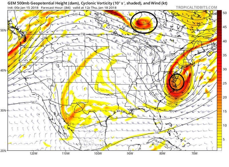
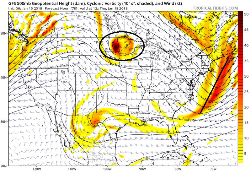
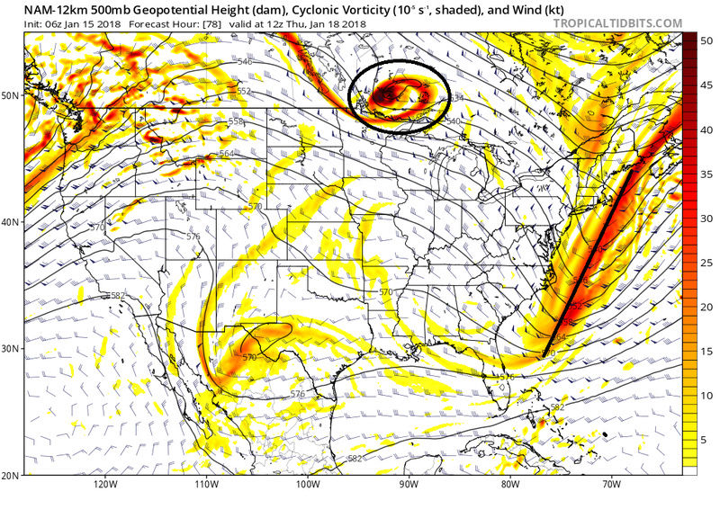
Regarding wave two: CMC tried to bring the second wave back. Basically 3 days out and look at the differences between 3 diff models at H5. Of course H5 closed off on CMC. As I have cont to outline this has to happen for wave two to materialize : result wave two coastal affecting the area. Also pay attention at where the kicker is. GFS furthest south, CMC furthest N and NAM in the middle. I'm still on board with the progressive soln, but the kicker energy wont be onshore for at least 24-48hrs, so we have to cont to watch this.


_________________
"In weather and in life, there's no winning and losing; there's only winning and learning."
WINTER 2012/2013 TOTALS 43.65"WINTER 2017/2018 TOTALS 62.85" WINTER 2022/2023 TOTALS 4.9"
WINTER 2013/2014 TOTALS 64.85"WINTER 2018/2019 TOTALS 14.25" WINTER 2023/2024 TOTALS 13.1"
WINTER 2014/2015 TOTALS 71.20"WINTER 2019/2020 TOTALS 6.35" WINTER 2024/2025 TOTALS 0.00
WINTER 2015/2016 TOTALS 35.00"WINTER 2020/2021 TOTALS 37.75"
WINTER 2016/2017 TOTALS 42.25"WINTER 2021/2022 TOTALS 31.65"

sroc4- Admin

- Posts : 8458
Reputation : 302
Join date : 2013-01-07
Location : Wading River, LI
 Re: Long Range Thread 16.0
sroc4 wrote:Wave 1 showing signs of some possible weak amplification as weak LP hits the coast. Of course this could lead to a warm nose trying to poke its way into the mid levels for the coast. Briefly Looking at soundings GFS and CMC are warmest making mixing from NYC on east a possible issue, but NAM is colder. There is a 1050mb HP in SE Canada which may keep the Low Level cold(LLC) in place. Its actually possible that if we get a little enhancement to LP development and precip that N&W areas could do a little better; whereas, I believe this would hurt the coast with mixing issues and or very low ratios. The typical S&E gets the better QPF but N&W gets the better ratio scenario.
Regarding wave two: CMC tried to bring the second wave back. Basically 3 days out and look at the differences between 3 diff models at H5. Of course H5 closed off on CMC: result wave two coastal affecting the area. Also pay attention at where the kicker is. GFS furthest south, CMC furthest N and NAM in the middle. I'm still on board with the progressive soln, but the kicker energy wont be onshore for at least 24-48hrs, so we have to cont to watch this.
Thank you Doc for your fine work here.NWS has me for 2 to 4 total so I'm happy with that and maybe a sweetner if that coastal comes across.Stay tuned! Anyhoo, it will be good to see a snow covered ground before the next 'thaw".

docstox12- Wx Statistician Guru

- Posts : 8615
Reputation : 222
Join date : 2013-01-07
Age : 74
Location : Monroe NY
 Re: Long Range Thread 16.0
For Mike AKA Warmiscist - just for your eye - the THAW!!!
.png)
.png)
_________________
Mugs
AKA:King: Snow Weenie
Self Proclaimed
WINTER 2014-15 : 55.12" +.02 for 6 coatings (avg. 35")
WINTER 2015-16 Total - 29.8" (Avg 35")
WINTER 2016-17 : 39.5" so far

amugs- Advanced Forecaster - Mod

- Posts : 15150
Reputation : 213
Join date : 2013-01-07
Age : 54
Location : Hillsdale,NJ
 Re: Long Range Thread 16.0
amugs wrote:For Mike AKA Warmiscist - just for your eye - the THAW!!!
UGH.To me that's like showing Dracula a mirror or garlic!!!!!! GO AWAY, BLAH!!!!

docstox12- Wx Statistician Guru

- Posts : 8615
Reputation : 222
Join date : 2013-01-07
Age : 74
Location : Monroe NY
 Re: Long Range Thread 16.0
docstox12 wrote:amugs wrote:For Mike AKA Warmiscist - just for your eye - the THAW!!!
UGH.To me that's like showing Dracula a mirror or garlic!!!!!! GO AWAY, BLAH!!!!
I know but we reload winter after this and it looks to have some staying power through early March as per latest info/data.
_________________
Mugs
AKA:King: Snow Weenie
Self Proclaimed
WINTER 2014-15 : 55.12" +.02 for 6 coatings (avg. 35")
WINTER 2015-16 Total - 29.8" (Avg 35")
WINTER 2016-17 : 39.5" so far

amugs- Advanced Forecaster - Mod

- Posts : 15150
Reputation : 213
Join date : 2013-01-07
Age : 54
Location : Hillsdale,NJ
 Re: Long Range Thread 16.0
To kick off the reloading of winter - don't take the rain/snow verbatim - LP in this position in January = Snow for CNJ North


_________________
Mugs
AKA:King: Snow Weenie
Self Proclaimed
WINTER 2014-15 : 55.12" +.02 for 6 coatings (avg. 35")
WINTER 2015-16 Total - 29.8" (Avg 35")
WINTER 2016-17 : 39.5" so far

amugs- Advanced Forecaster - Mod

- Posts : 15150
Reputation : 213
Join date : 2013-01-07
Age : 54
Location : Hillsdale,NJ
 Re: Long Range Thread 16.0
amugs wrote:docstox12 wrote:amugs wrote:For Mike AKA Warmiscist - just for your eye - the THAW!!!
UGH.To me that's like showing Dracula a mirror or garlic!!!!!! GO AWAY, BLAH!!!!
I know but we reload winter after this and it looks to have some staying power through early March as per latest info/data.
I will gladly offer a sacrifice, perhaps Math,to the Warmacist Gods and offer up this weekend if the pattern re loads to winter through early March.

docstox12- Wx Statistician Guru

- Posts : 8615
Reputation : 222
Join date : 2013-01-07
Age : 74
Location : Monroe NY
 Re: Long Range Thread 16.0
docstox12 wrote:amugs wrote:docstox12 wrote:amugs wrote:For Mike AKA Warmiscist - just for your eye - the THAW!!!
UGH.To me that's like showing Dracula a mirror or garlic!!!!!! GO AWAY, BLAH!!!!
I know but we reload winter after this and it looks to have some staying power through early March as per latest info/data.
I will gladly offer a sacrifice, perhaps Math,to the Warmacist Gods and offer up this weekend if the pattern re loads to winter through early March.
LOL yea, temps in the 50's this weekend. It will be a beautiful day for football. For those that know me, you knew that I lived in Jacksonville FL for quite some time so the Jags have been my team since 1995. Pittsburgh was their coldest game and going forward the pats game will feel like a cold front in FL for them. Considering how cold the month started, these warm spells have been pretty high. 60 last weekend and wouldn't be surprised if we get to the high 50's this weekend.

HectorO- Pro Enthusiast

- Posts : 976
Reputation : 27
Join date : 2013-01-11
 Re: Long Range Thread 16.0
GFS has a miller B at 204 hours
Ensembles have a cold pattern starting from hour 174 through the end of the run with a storm signal near the 29-29th.
Not a big thaw at all
Ensembles have a cold pattern starting from hour 174 through the end of the run with a storm signal near the 29-29th.
Not a big thaw at all

Snow88- Senior Enthusiast

- Posts : 2193
Reputation : 4
Join date : 2013-01-09
Age : 36
Location : Brooklyn, NY
 Re: Long Range Thread 16.0
Snow88 wrote:GFS has a miller B at 204 hours
Ensembles have a cold pattern starting from hour 174 through the end of the run with a storm signal near the 29-29th.
Not a big thaw at all
thats 7 days of warm weather thats pretty long.

jmanley32- Senior Enthusiast

- Posts : 20646
Reputation : 108
Join date : 2013-12-12
Age : 43
Location : Yonkers, NY
 Re: Long Range Thread 16.0
The torch that some were saying would be from the 12thish to the endish of the month has been delayed as we can see. Question now becomes what will teh next 10 days look like as well relax teh pattern and look to reload and get our winter arses back in gear for teh final stretch coem February into March.
40's and dasy around 50 will be for some 2-3 day stretches with a cold day or two in between. Nights will be cold.
I hate to sound like this but looking at NYC yuo can claim I am wrong - I dont live on or in that furnace that has a 4-6* temperature differences at night that my neck of the woods by is about 17 miles by a crows flight from the tip of Manhattan. except summe rtiem of course.
Hope the MJO for GEFS verifies over the Euro - phase 6 is furnace for us

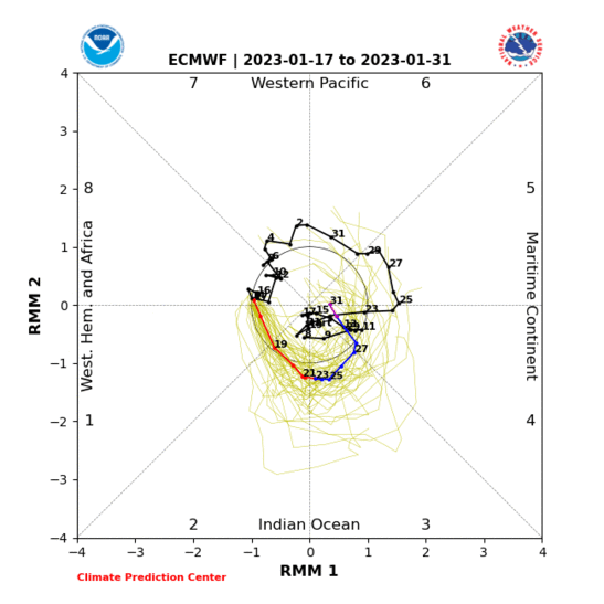
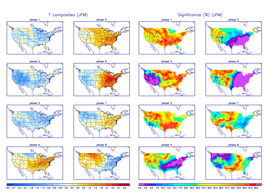
Albeit weak thank god but we have other variables that may help override this wave to an extent
40's and dasy around 50 will be for some 2-3 day stretches with a cold day or two in between. Nights will be cold.
I hate to sound like this but looking at NYC yuo can claim I am wrong - I dont live on or in that furnace that has a 4-6* temperature differences at night that my neck of the woods by is about 17 miles by a crows flight from the tip of Manhattan. except summe rtiem of course.
Hope the MJO for GEFS verifies over the Euro - phase 6 is furnace for us


Albeit weak thank god but we have other variables that may help override this wave to an extent
_________________
Mugs
AKA:King: Snow Weenie
Self Proclaimed
WINTER 2014-15 : 55.12" +.02 for 6 coatings (avg. 35")
WINTER 2015-16 Total - 29.8" (Avg 35")
WINTER 2016-17 : 39.5" so far

amugs- Advanced Forecaster - Mod

- Posts : 15150
Reputation : 213
Join date : 2013-01-07
Age : 54
Location : Hillsdale,NJ
Page 28 of 40 •  1 ... 15 ... 27, 28, 29 ... 34 ... 40
Page 28 of 40
Permissions in this forum:
You cannot reply to topics in this forum
 Home
Home
