Long Range Thread 16.0
+44
snowday111
HectorO
Grselig
essexcountypete
Snow88
mwilli5783
WeatherBob
NjWeatherGuy
Dunnzoo
jake732
aiannone
crippo84
bobjohnsonforthehall
Scullybutcher
algae888
dsix85
dkodgis
sroc4
emokid51783
Math23x7
Sanchize06
docstox12
billg315
oldtimer
CPcantmeasuresnow
skinsfan1177
Quietace
SENJsnowman
lglickman1
hyde345
MattyICE
Carter bk
RJB8525
jimv45
amugs
GreyBeard
weatherwatchermom
SoulSingMG
nutleyblizzard
mikeypizano
rb924119
frank 638
jmanley32
Frank_Wx
48 posters
Page 29 of 40
Page 29 of 40 •  1 ... 16 ... 28, 29, 30 ... 34 ... 40
 Re: Long Range Thread 16.0
Snow88 wrote:GFS has a miller B at 204 hours
Ensembles have a cold pattern starting from hour 174 through the end of the run with a storm signal near the 29-29th.
Not a big thaw at all
thats 7 days of warm weather thats pretty long.
jmanley32- Senior Enthusiast

- Posts : 20645
Join date : 2013-12-12
 Re: Long Range Thread 16.0
The torch that some were saying would be from the 12thish to the endish of the month has been delayed as we can see. Question now becomes what will teh next 10 days look like as well relax teh pattern and look to reload and get our winter arses back in gear for teh final stretch coem February into March.
40's and dasy around 50 will be for some 2-3 day stretches with a cold day or two in between. Nights will be cold.
I hate to sound like this but looking at NYC yuo can claim I am wrong - I dont live on or in that furnace that has a 4-6* temperature differences at night that my neck of the woods by is about 17 miles by a crows flight from the tip of Manhattan. except summe rtiem of course.
Hope the MJO for GEFS verifies over the Euro - phase 6 is furnace for us

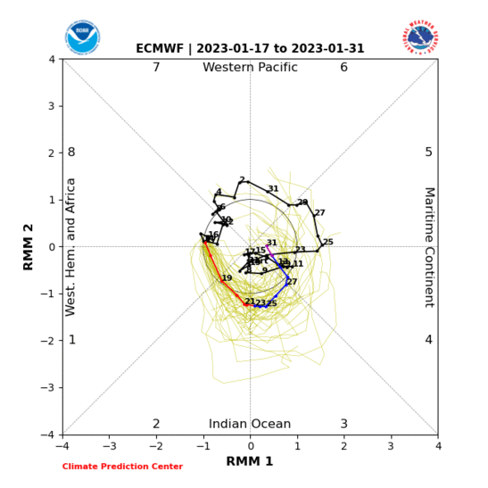
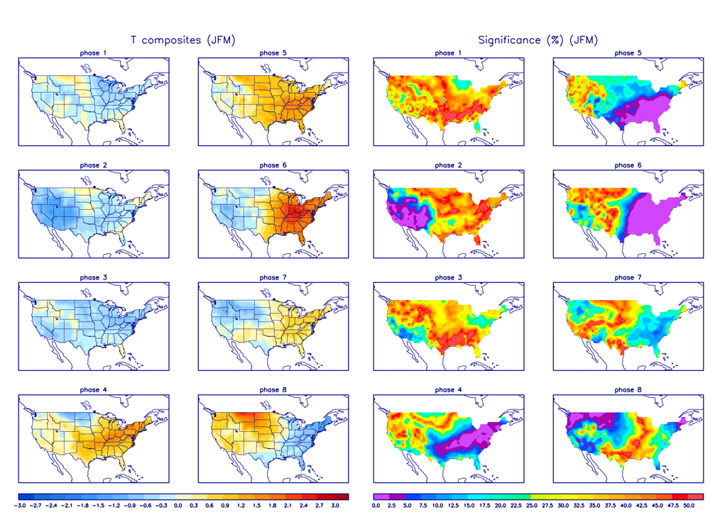
Albeit weak thank god but we have other variables that may help override this wave to an extent
40's and dasy around 50 will be for some 2-3 day stretches with a cold day or two in between. Nights will be cold.
I hate to sound like this but looking at NYC yuo can claim I am wrong - I dont live on or in that furnace that has a 4-6* temperature differences at night that my neck of the woods by is about 17 miles by a crows flight from the tip of Manhattan. except summe rtiem of course.
Hope the MJO for GEFS verifies over the Euro - phase 6 is furnace for us


Albeit weak thank god but we have other variables that may help override this wave to an extent
amugs- Advanced Forecaster - Mod

- Posts : 15149
Join date : 2013-01-07
 Re: Long Range Thread 16.0
We have had some decent snow events the past month and a half. Unfortunately, it appears that will be without another decent snow event for weeks, perhaps longer. That's not pessimism, that's reality.
Math23x7- Wx Statistician Guru

- Posts : 2382
Reputation : 68
Join date : 2013-01-08
 Re: Long Range Thread 16.0
Math23x7 wrote:We have had some decent snow events the past month and a half. Unfortunately, it appears that will be without another decent snow event for weeks, perhaps longer. That's not pessimism, that's reality.
What’s happened to you since you moved to NYC? Love ya but
 Your pessimism is scary buddy.
Guest- Guest
 Re: Long Range Thread 16.0
syosnow94 wrote:Math23x7 wrote:We have had some decent snow events the past month and a half. Unfortunately, it appears that will be without another decent snow event for weeks, perhaps longer. That's not pessimism, that's reality.
What’s happened to you since you moved to NYC? Love ya butYour pessimism is scary buddy.
I lived in NYC before I moved last month
Math23x7- Wx Statistician Guru

- Posts : 2382
Reputation : 68
Join date : 2013-01-08
 Re: Long Range Thread 16.0
math ya need to move to FL, then you can get all the warmth you want with the occassional snow like this year lolMath23x7 wrote:syosnow94 wrote:Math23x7 wrote:We have had some decent snow events the past month and a half. Unfortunately, it appears that will be without another decent snow event for weeks, perhaps longer. That's not pessimism, that's reality.
What’s happened to you since you moved to NYC? Love ya butYour pessimism is scary buddy.
I lived in NYC before I moved last month
Totally kidding but you seemed to used to be much more into wishing for snow.
Anyways who thinks this warm up will bust because I recall a bit over or around a week ago we were talking 50s or 60s starting around the 16th... Ummm, ya didnt happen.

jmanley32- Senior Enthusiast

- Posts : 20645
Reputation : 108
Join date : 2013-12-12
Age : 43
Location : Yonkers, NY
 Re: Long Range Thread 16.0
jmanley32 wrote:math ya need to move to FL, then you can get all the warmth you want with the occassional snow like this year lolMath23x7 wrote:syosnow94 wrote:Math23x7 wrote:We have had some decent snow events the past month and a half. Unfortunately, it appears that will be without another decent snow event for weeks, perhaps longer. That's not pessimism, that's reality.
What’s happened to you since you moved to NYC? Love ya butYour pessimism is scary buddy.
I lived in NYC before I moved last month
Totally kidding but you seemed to used to be much more into wishing for snow.
Anyways who thinks this warm up will bust because I recall a bit over or around a week ago we were talking 50s or 60s starting around the 16th... Ummm, ya didnt happen.
Good point Ajman these big thaws seemto keep changing into a few days of 40’s and low 50’s which are 10-15 degrees above normal and annoying but not the early spring many people onmany boards keep declaring. Math our friend has unfortunately become a proud card carrying Warmist. I do t think we can deny that anymore. It would be like denying your chronicWind Mania or my obsessive measuritis, or Syos over measuritis or RBs under measuritis. We all have chronic ailments but we still remain friends. It’s a beautiful thing. Let’s sing kumbaya.

CPcantmeasuresnow- Wx Statistician Guru

- Posts : 7284
Reputation : 230
Join date : 2013-01-07
Age : 103
Location : Eastern Orange County, NY
 Re: Long Range Thread 16.0
yeah I do not what has gotten into mike. he wasn't like this. I just think he is a spoiled child. he is young and he hasn't lived through the snowless years (decades) like the 80's. all I know is that the last decade or so it wants to snow here even with the warming climate and well above normal monthly departures. I will say this of our upcoming pattern watch out right after any cold shots. we have managed to snow in crappy patterns the last few years almost every time it got cold between the extreme warmth.CPcantmeasuresnow wrote:jmanley32 wrote:math ya need to move to FL, then you can get all the warmth you want with the occassional snow like this year lolMath23x7 wrote:syosnow94 wrote:Math23x7 wrote:We have had some decent snow events the past month and a half. Unfortunately, it appears that will be without another decent snow event for weeks, perhaps longer. That's not pessimism, that's reality.
What’s happened to you since you moved to NYC? Love ya butYour pessimism is scary buddy.
I lived in NYC before I moved last month
Totally kidding but you seemed to used to be much more into wishing for snow.
Anyways who thinks this warm up will bust because I recall a bit over or around a week ago we were talking 50s or 60s starting around the 16th... Ummm, ya didnt happen.
Good point Ajman these big thaws seemto keep changing into a few days of 40’s and low 50’s which are 10-15 degrees above normal and annoying but not the early spring many people onmany boards keep declaring. Math our friend has unfortunately become a proud card carrying Warmist. I do t think we can deny that anymore. It would be like denying your chronicWind Mania or my obsessive measuritis, or Syos over measuritis or RBs under measuritis. We all have chronic ailments but we still remain friends. It’s a beautiful thing. Let’s sing kumbaya.

algae888- Advanced Forecaster

- Posts : 5311
Reputation : 46
Join date : 2013-02-05
Age : 62
Location : mt. vernon, new york
 Re: Long Range Thread 16.0
A "January Thaw" ( why do I hate this terminology) happens even in the most brutal of winters.So far in my area I just see the mid to high 40's which is above normal but not torching.One thing I have noticed in winter is the "payback effect".It seems that right after a short period of above normal temps a snow event occurs.Sometimes it happens a little later.Case in point was last winter.I was walking in a park near where my Mom's house is last February and trees were budding out with some leafs already opening.One would have thought the winter was going to be over.Shortly afterwards in March, up here we had a 20 inch snowstorm.Another classic example was the 1888 March Blizzard where a few days before, people were on blankets in Central Park sunning themselves.As our beloved Yogi Berra said "it ain't over til it's over) and I offer the early April snowstorm on 1982 as an example or the late March snowstorm of 1970, I think the 30th, of nearly one foot as examples.We have 2 1/2 solid months of snow time with an early April kicker in there, so any brief warm spell should be disregarded .

docstox12- Wx Statistician Guru

- Posts : 8612
Reputation : 222
Join date : 2013-01-07
Age : 74
Location : Monroe NY
 Re: Long Range Thread 16.0
So far this "January thaw" has been way overblown. I had 2 or 3 days this month above 45, one was 60, but thats it. I stand at 1* as I'm writing this with 8 inches OTG. My forecast highs for the next 5 days are 30,36,46,43,38. Not exactly tropical.

hyde345- Pro Enthusiast

- Posts : 1083
Reputation : 48
Join date : 2013-01-08
Location : Hyde Park, NY
 Re: Long Range Thread 16.0
hyde345 wrote:So far this "January thaw" has been way overblown. I had 2 or 3 days this month above 45, one was 60, but thats it. I stand at 1* as I'm writing this with 8 inches OTG. My forecast highs for the next 5 days are 30,36,46,43,38. Not exactly tropical.
And remember that high of 60 that did happen through a lot of our area was not even a one day thing it was about a six hour long thing.
The average high temperatures this time of year are anywhere from 33 to 35 in the Hudson Valley, to the high 30s around the New York City area and in New York City itself. When I look on my long-range and I see a couple of highs projected out there in the mid to high 40s it's annoying that is 10 to 15° above normal for this time of year but if that's the January thaw so be it.
What has been annoying in recent winters is some of these ridiculous streaks of temperatures in the 50s and even some low 60s which are full-blown torches but it doesn't seem like we are headed towards. At least I hope not, but our experts here could answer that much better than I.

CPcantmeasuresnow- Wx Statistician Guru

- Posts : 7284
Reputation : 230
Join date : 2013-01-07
Age : 103
Location : Eastern Orange County, NY
 Re: Long Range Thread 16.0
The only way I see 60° getting back into our area is the 6 to 12 hours prior to a cutter/ cold frontal Passage. otherwise the best way to describe the upcoming pattern is seasonably mild with brief cooldownsCPcantmeasuresnow wrote:hyde345 wrote:So far this "January thaw" has been way overblown. I had 2 or 3 days this month above 45, one was 60, but thats it. I stand at 1* as I'm writing this with 8 inches OTG. My forecast highs for the next 5 days are 30,36,46,43,38. Not exactly tropical.
And remember that high of 60 that did happen through a lot of our area was not even a one day thing it was about a six hour long thing.
The average high temperatures this time of year are anywhere from 33 to 35 in the Hudson Valley, to the high 30s around the New York City area and in New York City itself. When I look on my long-range and I see a couple of highs projected out there in the mid to high 40s it's annoying that is 10 to 15° above normal for this time of year but if that's the January thaw so be it.
What has been annoying in recent winters is some of these ridiculous streaks of temperatures in the 50s and even some low 60s which are full-blown torches but it doesn't seem like we are headed towards. At least I hope not, but our experts here could answer that much better than I.

algae888- Advanced Forecaster

- Posts : 5311
Reputation : 46
Join date : 2013-02-05
Age : 62
Location : mt. vernon, new york
 Re: Long Range Thread 16.0
Also if the temperature spread is say 47 / 32 and we get a system to go underneath us at night it will snow in late January

algae888- Advanced Forecaster

- Posts : 5311
Reputation : 46
Join date : 2013-02-05
Age : 62
Location : mt. vernon, new york
 Re: Long Range Thread 16.0
jmanley32 wrote:math ya need to move to FL, then you can get all the warmth you want with the occassional snow like this year lolMath23x7 wrote:syosnow94 wrote:Math23x7 wrote:We have had some decent snow events the past month and a half. Unfortunately, it appears that will be without another decent snow event for weeks, perhaps longer. That's not pessimism, that's reality.
What’s happened to you since you moved to NYC? Love ya butYour pessimism is scary buddy.
I lived in NYC before I moved last month
Totally kidding but you seemed to used to be much more into wishing for snow.
Anyways who thinks this warm up will bust because I recall a bit over or around a week ago we were talking 50s or 60s starting around the 16th... Ummm, ya didnt happen.
Perhaps it's "winter warlock" from the old ABC days..... I kid

HectorO- Pro Enthusiast

- Posts : 976
Reputation : 27
Join date : 2013-01-11
 Re: Long Range Thread 16.0
Math23x7 wrote:We have had some decent snow events the past month and a half. Unfortunately, it appears that will be without another decent snow event for weeks, perhaps longer. That's not pessimism, that's reality.
Mikey wth happens to you??
We can snow in a sht pattern - be 60* one day and snowstorm the next so throw this out the window.
There is a lot going on and we need to use ens mean smoothed out to HELP not forecast what will happen,
Pro Met forecaster is harping on 1-27 to 2/4 for a storm.
Isotherm is looking at a stretch from Feb 8thish to teh 25th for cold and storminess - give or take a couple of days.
The MJO phase is not the end of all of be all with making forecasts.
This in itself will fluctuate and as AL said all we need is a SW to undercut and BAM we have a snowstorm at this time of teh year with a frigid Canada waiting to drop us the cold.
The models are from what a pro met said biased to MJO phases especially in LR and will correct as they near - haven't we seen this a number of times?
Just sit back and let';s get through this weekend and see were things are headed.
_________________
Mugs
AKA:King: Snow Weenie
Self Proclaimed
WINTER 2014-15 : 55.12" +.02 for 6 coatings (avg. 35")
WINTER 2015-16 Total - 29.8" (Avg 35")
WINTER 2016-17 : 39.5" so far

amugs- Advanced Forecaster - Mod

- Posts : 15149
Reputation : 213
Join date : 2013-01-07
Age : 54
Location : Hillsdale,NJ
 Re: Long Range Thread 16.0
GEFS in the LR - 1 week out not bad
Maybe something track next week-like i said get past this weekend and we go from there - Mikey y7ou pissed off big momma!!!


Maybe something track next week-like i said get past this weekend and we go from there - Mikey y7ou pissed off big momma!!!


_________________
Mugs
AKA:King: Snow Weenie
Self Proclaimed
WINTER 2014-15 : 55.12" +.02 for 6 coatings (avg. 35")
WINTER 2015-16 Total - 29.8" (Avg 35")
WINTER 2016-17 : 39.5" so far

amugs- Advanced Forecaster - Mod

- Posts : 15149
Reputation : 213
Join date : 2013-01-07
Age : 54
Location : Hillsdale,NJ
 Re: Long Range Thread 16.0
amugs wrote:GEFS in the LR - 1 week out not bad
Maybe something track next week-like i said get past this weekend and we go from there - Mikey y7ou pissed off big momma!!!
I just went to hr 180 of the 1/18 12Z GFS-ENS on tropicaltidbits. I wouldn't exactly say favorable for snow unfortunately:
MLSP Anomaly:
https://www.tropicaltidbits.com/analysis/models/?model=gfs-ens®ion=namer&pkg=mslpaNorm&runtime=2018011812&fh=180
500 mb height Anomaly:
https://www.tropicaltidbits.com/analysis/models/?model=gfs-ens®ion=namer&pkg=z500a&runtime=2018011812&fh=180
Notice the howling Pacific jet in the latter link. Don't like the look of that.
Math23x7- Wx Statistician Guru

- Posts : 2382
Reputation : 68
Join date : 2013-01-08
 Re: Long Range Thread 16.0
Math23x7 wrote:amugs wrote:GEFS in the LR - 1 week out not bad
Maybe something track next week-like i said get past this weekend and we go from there - Mikey y7ou pissed off big momma!!!
I just went to hr 180 of the 1/18 12Z GFS-ENS on tropicaltidbits. I wouldn't exactly say favorable for snow unfortunately:
MLSP Anomaly:
https://www.tropicaltidbits.com/analysis/models/?model=gfs-ens®ion=namer&pkg=mslpaNorm&runtime=2018011812&fh=180
500 mb height Anomaly:
https://www.tropicaltidbits.com/analysis/models/?model=gfs-ens®ion=namer&pkg=z500a&runtime=2018011812&fh=180
Notice the howling Pacific jet in the latter link. Don't like the look of that.
That is hardley a howling Pac jet at the time frame your looking at.

_________________
"In weather and in life, there's no winning and losing; there's only winning and learning."
WINTER 2012/2013 TOTALS 43.65"WINTER 2017/2018 TOTALS 62.85" WINTER 2022/2023 TOTALS 4.9"
WINTER 2013/2014 TOTALS 64.85"WINTER 2018/2019 TOTALS 14.25" WINTER 2023/2024 TOTALS 13.1"
WINTER 2014/2015 TOTALS 71.20"WINTER 2019/2020 TOTALS 6.35" WINTER 2024/2025 TOTALS 0.00
WINTER 2015/2016 TOTALS 35.00"WINTER 2020/2021 TOTALS 37.75"
WINTER 2016/2017 TOTALS 42.25"WINTER 2021/2022 TOTALS 31.65"

sroc4- Admin

- Posts : 8458
Reputation : 302
Join date : 2013-01-07
Location : Wading River, LI
 Re: Long Range Thread 16.0
Mike for the luv of god I never said " favorable for snow " I just said it is something we may be able to track.
That PAC Jet has a buckle and needs some work BUT IF we get the heights to rise on the West Coast it could bring us something IF timed right.
It maybe nothing a cutter or something of interest.
That PAC Jet has a buckle and needs some work BUT IF we get the heights to rise on the West Coast it could bring us something IF timed right.
It maybe nothing a cutter or something of interest.
_________________
Mugs
AKA:King: Snow Weenie
Self Proclaimed
WINTER 2014-15 : 55.12" +.02 for 6 coatings (avg. 35")
WINTER 2015-16 Total - 29.8" (Avg 35")
WINTER 2016-17 : 39.5" so far

amugs- Advanced Forecaster - Mod

- Posts : 15149
Reputation : 213
Join date : 2013-01-07
Age : 54
Location : Hillsdale,NJ
 Re: Long Range Thread 16.0
Keep it going Mike. Love watching these weenies squirm.

moleson- Posts : 34
Reputation : 0
Join date : 2013-01-07
 Re: Long Range Thread 16.0
What kind of bizarre post is that. That really is a bad way to use one of your 1.9 posts per year.moleson wrote:Keep it going Mike. Love watching these weenies squirm.
Guest- Guest
 Re: Long Range Thread 16.0
syosnow94 wrote:What kind of bizarre post is that. That really is a bad way to use one of your 1.9 posts per year.moleson wrote:Keep it going Mike. Love watching these weenies squirm.
5 years a member and 9 posts total equal 1.8 posts per year.
Bad at measuring snow and at division, but an excellent Director of Mental Health Services.

CPcantmeasuresnow- Wx Statistician Guru

- Posts : 7284
Reputation : 230
Join date : 2013-01-07
Age : 103
Location : Eastern Orange County, NY
 Re: Long Range Thread 16.0
Okay guys lets chill (pun intended). I know we kid but things are get a bit off track, so back to the LR whats going to happen after the weekend? Do we see snow through march or is it going to at some pt be an early spring? I really would like to see one really solid snowstorm though the "bomb cyclone" was not the worst but there have been much better.CPcantmeasuresnow wrote:syosnow94 wrote:What kind of bizarre post is that. That really is a bad way to use one of your 1.9 posts per year.moleson wrote:Keep it going Mike. Love watching these weenies squirm.
5 years a member and 9 posts total equal 1.8 posts per year.
Bad at measuring snow and at division, but an excellent Director of Mental Health Services.

jmanley32- Senior Enthusiast

- Posts : 20645
Reputation : 108
Join date : 2013-12-12
Age : 43
Location : Yonkers, NY
 Re: Long Range Thread 16.0
I still stand firmly behind my thoughts that we will return to the same type of pattern we saw in December and the first half of this month once we get through the first seven to ten days of February. I think we reload, lock, and rock right through the middle to end of March this year. The Strat continues to take a big hit from a strong and coordinated Wave -1 attack, which should begin to manifest itself around the same time I outlined for the switch. This will also be coordinated with what is likely to be an amplified MJO pulse emerging into the cold phases concomitantly, and amplification of the entire Northern Hemispheric Rossby Wave train as the pattern shifts in response. Our winter should not be over by a long shot, and I'm actually pretty excited for beyond February 10th.
rb924119- Meteorologist

- Posts : 7107
Reputation : 195
Join date : 2013-02-06
Age : 32
Location : Greentown, Pa
 Re: Long Range Thread 16.0
rb924119 wrote:I still stand firmly behind my thoughts that we will return to the same type of pattern we saw in December and the first half of this month once we get through the first seven to ten days of February. I think we reload, lock, and rock right through the middle to end of March this year. The Strat continues to take a big hit from a strong and coordinated Wave -1 attack, which should begin to manifest itself around the same time I outlined for the switch. This will also be coordinated with what is likely to be an amplified MJO pulse emerging into the cold phases concomitantly, and amplification of the entire Northern Hemispheric Rossby Wave train as the pattern shifts in response. Our winter should not be over by a long shot, and I'm actually pretty excited for beyond February 10th.
Agree 100%. That said we are still contingent upon the actual response by the strat from the most recent and soon to be follow up wave 1 attack. There is also a rumbling of a significant wave 2 attack for late Jan into first week of Feb which hopefully finishes the job and set us up for what could be a wild 3-6 week period to end our season. Unfort between now and early to mid Feb in addition to getting through the actual “thaw” we will have to get through the whiningfrom those who claim “winter is over” as well as the warm weenie comments. Such is life I suppose. I do see a possible window in the 7-10day that could evolve over time to a possible chance at snow but it’s not very obvious in the modeling. You would have to read between the lines in the ensemble forecasts to see what I’m talking about. If you look at operations you won’t see it. Again it may be a reach but at least it’s something to watch.
_________________
"In weather and in life, there's no winning and losing; there's only winning and learning."
WINTER 2012/2013 TOTALS 43.65"WINTER 2017/2018 TOTALS 62.85" WINTER 2022/2023 TOTALS 4.9"
WINTER 2013/2014 TOTALS 64.85"WINTER 2018/2019 TOTALS 14.25" WINTER 2023/2024 TOTALS 13.1"
WINTER 2014/2015 TOTALS 71.20"WINTER 2019/2020 TOTALS 6.35" WINTER 2024/2025 TOTALS 0.00
WINTER 2015/2016 TOTALS 35.00"WINTER 2020/2021 TOTALS 37.75"
WINTER 2016/2017 TOTALS 42.25"WINTER 2021/2022 TOTALS 31.65"

sroc4- Admin

- Posts : 8458
Reputation : 302
Join date : 2013-01-07
Location : Wading River, LI
 Re: Long Range Thread 16.0
Oh yeah, Scott, definitely agree with a sneaky threat or two.....or three lol with such a strongly negative AO and an overall progressive pattern, it will not take much for one of these spokes rotating in through the main trough in the west to actually cut beneath and/or behind western Atlantic/North American ridging. If you're looking for ways it can snow in an overall ugly pattern, that's how. It won't last long, but it would be something. Plus, in this type of setup, progressiveness will limit the extent to which we get above normal; though by the same token will also limit how cool we can get with any quick shots from those sneaky short waves.
rb924119- Meteorologist

- Posts : 7107
Reputation : 195
Join date : 2013-02-06
Age : 32
Location : Greentown, Pa
 Re: Long Range Thread 16.0
Here is what I'm talking about for the end of the month on the ensembles. What seems to be consistent on both GEFS and EPS is the development of a strong -WPO blocking ridge by day 7 +/- a day or two. This will likely have down stream effects on the 500mb pattern that this far out the will likely be hidden in the means. What I mean by this is that recall the ensemble mean 500mb charts are a smoothed out average of all its individual members. The actual soln is hidden among the mean, but because there is still such a wide spread of solns within all the individual members of an ensemble mean forecast that far out in time, the result of what your looking at now in the 7-10day and beyond could be off by a significant margin from the end soln. The mean forecast on an ensemble ends up correcting as we get closer in time and more and more individual members start converging/correcting towards the actual soln.
Again with a strong -WPO by day 7 or so AND a -AO, 2-3days later we may see a piece of energy release from the west coast as hopefully a transient ridge in the PNA and/or EPO region occurs in response to the -WPO/-AO block. IF this happens the "possibility" of a Canadian HP dropping far enough south such that this energy comes underneath towards the EC having a cold air source to tap into. Remember this is a long way off in a pattern that is not overtly conducive to a storm, but there are ways for it to happen. This has been proven over the last two winters. It would have to be the preverbal the pieces have to come together "just right" scenario so for now odds are certainly against this from happening, BUT....for now at least its something to monitor. Update on the evolution of the ensemble forecast in a few days.
GEFS:


EPS:

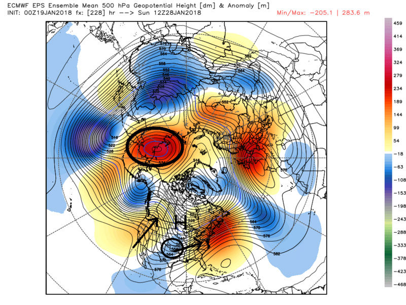
Again with a strong -WPO by day 7 or so AND a -AO, 2-3days later we may see a piece of energy release from the west coast as hopefully a transient ridge in the PNA and/or EPO region occurs in response to the -WPO/-AO block. IF this happens the "possibility" of a Canadian HP dropping far enough south such that this energy comes underneath towards the EC having a cold air source to tap into. Remember this is a long way off in a pattern that is not overtly conducive to a storm, but there are ways for it to happen. This has been proven over the last two winters. It would have to be the preverbal the pieces have to come together "just right" scenario so for now odds are certainly against this from happening, BUT....for now at least its something to monitor. Update on the evolution of the ensemble forecast in a few days.
GEFS:


EPS:


Last edited by sroc4 on Tue Jan 30, 2018 6:41 am; edited 1 time in total
_________________
"In weather and in life, there's no winning and losing; there's only winning and learning."
WINTER 2012/2013 TOTALS 43.65"WINTER 2017/2018 TOTALS 62.85" WINTER 2022/2023 TOTALS 4.9"
WINTER 2013/2014 TOTALS 64.85"WINTER 2018/2019 TOTALS 14.25" WINTER 2023/2024 TOTALS 13.1"
WINTER 2014/2015 TOTALS 71.20"WINTER 2019/2020 TOTALS 6.35" WINTER 2024/2025 TOTALS 0.00
WINTER 2015/2016 TOTALS 35.00"WINTER 2020/2021 TOTALS 37.75"
WINTER 2016/2017 TOTALS 42.25"WINTER 2021/2022 TOTALS 31.65"

sroc4- Admin

- Posts : 8458
Reputation : 302
Join date : 2013-01-07
Location : Wading River, LI
Page 29 of 40 •  1 ... 16 ... 28, 29, 30 ... 34 ... 40
Page 29 of 40
Permissions in this forum:
You cannot reply to topics in this forum
 Home
Home