Long Range Thread 16.0
+44
snowday111
HectorO
Grselig
essexcountypete
Snow88
mwilli5783
WeatherBob
NjWeatherGuy
Dunnzoo
jake732
aiannone
crippo84
bobjohnsonforthehall
Scullybutcher
algae888
dsix85
dkodgis
sroc4
emokid51783
Math23x7
Sanchize06
docstox12
billg315
oldtimer
CPcantmeasuresnow
skinsfan1177
Quietace
SENJsnowman
lglickman1
hyde345
MattyICE
Carter bk
RJB8525
jimv45
amugs
GreyBeard
weatherwatchermom
SoulSingMG
nutleyblizzard
mikeypizano
rb924119
frank 638
jmanley32
Frank_Wx
48 posters
Page 30 of 40
Page 30 of 40 •  1 ... 16 ... 29, 30, 31 ... 35 ... 40
 Re: Long Range Thread 16.0
Oh yeah, Scott, definitely agree with a sneaky threat or two.....or three lol with such a strongly negative AO and an overall progressive pattern, it will not take much for one of these spokes rotating in through the main trough in the west to actually cut beneath and/or behind western Atlantic/North American ridging. If you're looking for ways it can snow in an overall ugly pattern, that's how. It won't last long, but it would be something. Plus, in this type of setup, progressiveness will limit the extent to which we get above normal; though by the same token will also limit how cool we can get with any quick shots from those sneaky short waves.
rb924119- Meteorologist

- Posts : 7103
Join date : 2013-02-06
 Re: Long Range Thread 16.0
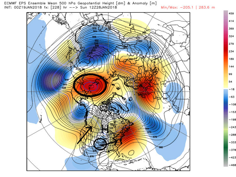
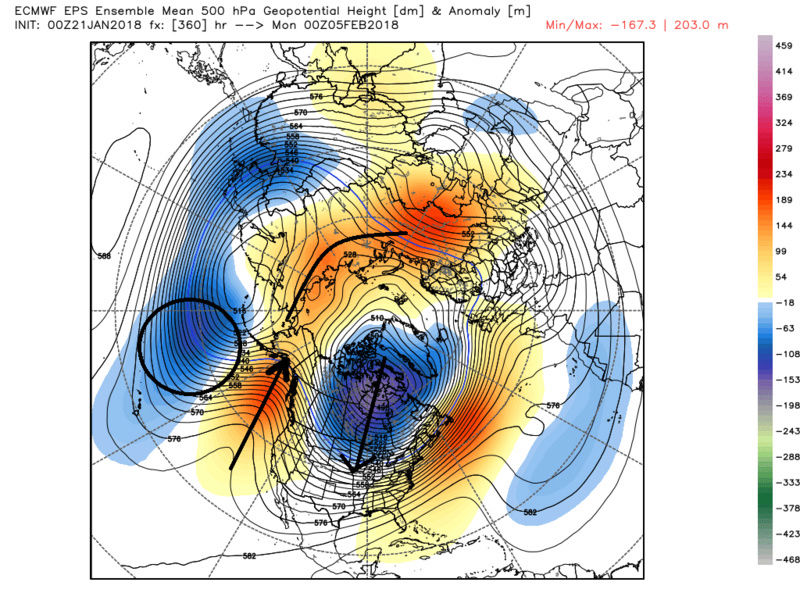
Here is what I'm talking about for the end of the month on the ensembles. What seems to be consistent on both GEFS and EPS is the development of a strong -WPO blocking ridge by day 7 +/- a day or two. This will likely have down stream effects on the 500mb pattern that this far out the will likely be hidden in the means. What I mean by this is that recall the ensemble mean 500mb charts are a smoothed out average of all its individual members. The actual soln is hidden among the mean, but because there is still such a wide spread of solns within all the individual members of an ensemble mean forecast that far out in time, the result of what your looking at now in the 7-10day and beyond could be off by a significant margin from the end soln. The mean forecast on an ensemble ends up correcting as we get closer in time and more and more individual members start converging/correcting towards the actual soln.
Again with a strong -WPO by day 7 or so AND a -AO, 2-3days later we may see a piece of energy release from the west coast as hopefully a transient ridge in the PNA and/or EPO region occurs in response to the -WPO/-AO block. IF this happens the "possibility" of a Canadian HP dropping far enough south such that this energy comes underneath towards the EC having a cold air source to tap into. Remember this is a long way off in a pattern that is not overtly conducive to a storm, but there are ways for it to happen. This has been proven over the last two winters. It would have to be the preverbal the pieces have to come together "just right" scenario so for now odds are certainly against this from happening, BUT....for now at least its something to monitor. Update on the evolution of the ensemble forecast in a few days.
GEFS:


EPS:


Again with a strong -WPO by day 7 or so AND a -AO, 2-3days later we may see a piece of energy release from the west coast as hopefully a transient ridge in the PNA and/or EPO region occurs in response to the -WPO/-AO block. IF this happens the "possibility" of a Canadian HP dropping far enough south such that this energy comes underneath towards the EC having a cold air source to tap into. Remember this is a long way off in a pattern that is not overtly conducive to a storm, but there are ways for it to happen. This has been proven over the last two winters. It would have to be the preverbal the pieces have to come together "just right" scenario so for now odds are certainly against this from happening, BUT....for now at least its something to monitor. Update on the evolution of the ensemble forecast in a few days.
GEFS:


EPS:


Last edited by sroc4 on Tue Jan 30, 2018 6:41 am; edited 1 time in total
sroc4- Admin

- Posts : 8458
Join date : 2013-01-07
 Re: Long Range Thread 16.0
rb924119 wrote:Oh yeah, Scott, definitely agree with a sneaky threat or two.....or three lol with such a strongly negative AO and an overall progressive pattern, it will not take much for one of these spokes rotating in through the main trough in the west to actually cut beneath and/or behind western Atlantic/North American ridging. If you're looking for ways it can snow in an overall ugly pattern, that's how. It won't last long, but it would be something. Plus, in this type of setup, progressiveness will limit the extent to which we get above normal; though by the same token will also limit how cool we can get with any quick shots from those sneaky short waves.
Whats the saying??? Great minds......
_________________
"In weather and in life, there's no winning and losing; there's only winning and learning."
WINTER 2012/2013 TOTALS 43.65"WINTER 2017/2018 TOTALS 62.85" WINTER 2022/2023 TOTALS 4.9"
WINTER 2013/2014 TOTALS 64.85"WINTER 2018/2019 TOTALS 14.25" WINTER 2023/2024 TOTALS 13.1"
WINTER 2014/2015 TOTALS 71.20"WINTER 2019/2020 TOTALS 6.35" WINTER 2024/2025 TOTALS 0.00
WINTER 2015/2016 TOTALS 35.00"WINTER 2020/2021 TOTALS 37.75"
WINTER 2016/2017 TOTALS 42.25"WINTER 2021/2022 TOTALS 31.65"

sroc4- Admin

- Posts : 8458
Reputation : 302
Join date : 2013-01-07
Location : Wading River, LI
 Re: Long Range Thread 16.0
THE N WPO and BIG Time at that will do one thing for sure - OH CANADA - will be frozen and this cold air will be waiting to enter into the US.
OP's Scott will do poop with this progressive set up to find a storm that can undercut and gives us white gold in such a pattern.
Is it going to be 60* warm - I am not seeing such, a few days we hit 50, all depends on where you live in this area in this vast area of members on tis board. I am thinking that by the first week of Feb we reload the pattern. The N WPO usually helps pump the EPO and tehre are signs of wave breaks heading into that region in the time frame. Once it goes N the EPO then it wont take 5 -6 days to get cold here due to s cold Canada. The press will happen sooner like in 3 - I know what the difference well it can mean rain or white gold.
_________________
Mugs
AKA:King: Snow Weenie
Self Proclaimed
WINTER 2014-15 : 55.12" +.02 for 6 coatings (avg. 35")
WINTER 2015-16 Total - 29.8" (Avg 35")
WINTER 2016-17 : 39.5" so far

amugs- Advanced Forecaster - Mod

- Posts : 15148
Reputation : 213
Join date : 2013-01-07
Age : 54
Location : Hillsdale,NJ
 Re: Long Range Thread 16.0
syosnow94 wrote:AREA WIDE FRANKZILLA INCOMMING FEBRUARY 14th PER SYS!!!


_________________
Mugs
AKA:King: Snow Weenie
Self Proclaimed
WINTER 2014-15 : 55.12" +.02 for 6 coatings (avg. 35")
WINTER 2015-16 Total - 29.8" (Avg 35")
WINTER 2016-17 : 39.5" so far

amugs- Advanced Forecaster - Mod

- Posts : 15148
Reputation : 213
Join date : 2013-01-07
Age : 54
Location : Hillsdale,NJ
 Re: Long Range Thread 16.0
hey
_________________
"In weather and in life, there's no winning and losing; there's only winning and learning."
WINTER 2012/2013 TOTALS 43.65"WINTER 2017/2018 TOTALS 62.85" WINTER 2022/2023 TOTALS 4.9"
WINTER 2013/2014 TOTALS 64.85"WINTER 2018/2019 TOTALS 14.25" WINTER 2023/2024 TOTALS 13.1"
WINTER 2014/2015 TOTALS 71.20"WINTER 2019/2020 TOTALS 6.35" WINTER 2024/2025 TOTALS 0.00
WINTER 2015/2016 TOTALS 35.00"WINTER 2020/2021 TOTALS 37.75"
WINTER 2016/2017 TOTALS 42.25"WINTER 2021/2022 TOTALS 31.65"

sroc4- Admin

- Posts : 8458
Reputation : 302
Join date : 2013-01-07
Location : Wading River, LI
 Re: Long Range Thread 16.0
frankzilla on v-day,good cause i'll be home cause ill be retired by then(1/26)
mwilli5783- Posts : 146
Reputation : 9
Join date : 2013-01-23
Age : 70
Location : hempstead n.y
 Re: Long Range Thread 16.0
mwilli5783 wrote:frankzilla on v-day,good cause i'll be home cause ill be retired by then(1/26)
Happy Retirement!!! I hope you love it as much as I do. We should have a Retirement Club section on NJ Strong.One small little problem...now when a snowstorm is coming, you will be spending a LOT of time on this site,LOL.ENJOY!!!

docstox12- Wx Statistician Guru

- Posts : 8611
Reputation : 222
Join date : 2013-01-07
Age : 74
Location : Monroe NY
 Re: Long Range Thread 16.0
thanks doc..10 yrs with tgt..i can now spend more time here observing and reading comments on the weather
mwilli5783- Posts : 146
Reputation : 9
Join date : 2013-01-23
Age : 70
Location : hempstead n.y
 Re: Long Range Thread 16.0
Lets get back to the weather. Here is the first sign of the pattern shifting back to more sustained cold. Its long range so grain of salt for now but fits very nicely with the anticipated start to the sustained cold and snow chances. You can see a trough showing up S of the Aleutian islands which lends itself to a ridge then a full lat trough over NA showing up in the means of the ens. If you look at the MSLP anomalies when you start to see the HP building in this configuration the cold is coming. Verbatim the ridge axis is likely too far west for a snow storm for the east coast, but if I had to guess there would be a decent system develop from this look around the 4th-8th time frame that would prob cut but be the key to unlock the cold shortly after this from the 8th-12th time frame. Images are saved so we can follow along with the evolution a we go along in time.
Update on the 27th-30th time frame coming early this week.


Update on the 27th-30th time frame coming early this week.


_________________
"In weather and in life, there's no winning and losing; there's only winning and learning."
WINTER 2012/2013 TOTALS 43.65"WINTER 2017/2018 TOTALS 62.85" WINTER 2022/2023 TOTALS 4.9"
WINTER 2013/2014 TOTALS 64.85"WINTER 2018/2019 TOTALS 14.25" WINTER 2023/2024 TOTALS 13.1"
WINTER 2014/2015 TOTALS 71.20"WINTER 2019/2020 TOTALS 6.35" WINTER 2024/2025 TOTALS 0.00
WINTER 2015/2016 TOTALS 35.00"WINTER 2020/2021 TOTALS 37.75"
WINTER 2016/2017 TOTALS 42.25"WINTER 2021/2022 TOTALS 31.65"

sroc4- Admin

- Posts : 8458
Reputation : 302
Join date : 2013-01-07
Location : Wading River, LI
 Re: Long Range Thread 16.0
I peeped the 27th-30th period of which you speak. It's certainly a close call, but I don't like the ridge configuration. We need the Pacific ridge to be stronger than the Atlantic ridge, and given the background of the NH pattern I don't see that happening.
rb924119- Meteorologist

- Posts : 7103
Reputation : 195
Join date : 2013-02-06
Age : 32
Location : Greentown, Pa
 Re: Long Range Thread 16.0
rb924119 wrote:I peeped the 27th-30th period of which you speak. It's certainly a close call, but I don't like the ridge configuration. We need the Pacific ridge to be stronger than the Atlantic ridge, and given the background of the NH pattern I don't see that happening.
I hear ya. I said it before and I’ll reiterate it now. The odds and pattern def do not favor it. As of now it looks like the negatives crash the west coast of Canada right as the PNA ridge is maybe making a move and while our energy is releasing across the country. I’m not updating much because again we are still far enough out where the exact positions and timing of certain features still may be off due to the means so I need a few more days to see how it evolves and ensemble members tighten up. Again it’s at least a glimmer of something to track.
_________________
"In weather and in life, there's no winning and losing; there's only winning and learning."
WINTER 2012/2013 TOTALS 43.65"WINTER 2017/2018 TOTALS 62.85" WINTER 2022/2023 TOTALS 4.9"
WINTER 2013/2014 TOTALS 64.85"WINTER 2018/2019 TOTALS 14.25" WINTER 2023/2024 TOTALS 13.1"
WINTER 2014/2015 TOTALS 71.20"WINTER 2019/2020 TOTALS 6.35" WINTER 2024/2025 TOTALS 0.00
WINTER 2015/2016 TOTALS 35.00"WINTER 2020/2021 TOTALS 37.75"
WINTER 2016/2017 TOTALS 42.25"WINTER 2021/2022 TOTALS 31.65"

sroc4- Admin

- Posts : 8458
Reputation : 302
Join date : 2013-01-07
Location : Wading River, LI
 Re: Long Range Thread 16.0
For the record I am merely wishing upon a Star for a snow storm to happen in this time frame. I am NOT wish casting a storm. I want to be clear on that in case anyone was confused.
_________________
"In weather and in life, there's no winning and losing; there's only winning and learning."
WINTER 2012/2013 TOTALS 43.65"WINTER 2017/2018 TOTALS 62.85" WINTER 2022/2023 TOTALS 4.9"
WINTER 2013/2014 TOTALS 64.85"WINTER 2018/2019 TOTALS 14.25" WINTER 2023/2024 TOTALS 13.1"
WINTER 2014/2015 TOTALS 71.20"WINTER 2019/2020 TOTALS 6.35" WINTER 2024/2025 TOTALS 0.00
WINTER 2015/2016 TOTALS 35.00"WINTER 2020/2021 TOTALS 37.75"
WINTER 2016/2017 TOTALS 42.25"WINTER 2021/2022 TOTALS 31.65"

sroc4- Admin

- Posts : 8458
Reputation : 302
Join date : 2013-01-07
Location : Wading River, LI
 Re: Long Range Thread 16.0
rb924119 wrote:I peeped the 27th-30th period of which you speak. It's certainly a close call, but I don't like the ridge configuration. We need the Pacific ridge to be stronger than the Atlantic ridge, and given the background of the NH pattern I don't see that happening.
It's close on the GFS
The wave keeps shifting east
Remember when this was a huge cutter ?

Snow88- Senior Enthusiast

- Posts : 2193
Reputation : 4
Join date : 2013-01-09
Age : 36
Location : Brooklyn, NY
 Re: Long Range Thread 16.0
From Douglas Fresh 33&rain
250 looks.good delicate set up but may have a chance here as Tont Ronzoni has been tracking

EPO tanking as I was saying a few days ago with PAC wave breaks and an LP over N Hawaii that will help.pump this and the PNA ridge. This is around the 5th time frame that i have been taking about wr shift back to winter. It may also rise the heights over the top and connect the Atlantic if we're lucky .

250 looks.good delicate set up but may have a chance here as Tont Ronzoni has been tracking

EPO tanking as I was saying a few days ago with PAC wave breaks and an LP over N Hawaii that will help.pump this and the PNA ridge. This is around the 5th time frame that i have been taking about wr shift back to winter. It may also rise the heights over the top and connect the Atlantic if we're lucky .

_________________
Mugs
AKA:King: Snow Weenie
Self Proclaimed
WINTER 2014-15 : 55.12" +.02 for 6 coatings (avg. 35")
WINTER 2015-16 Total - 29.8" (Avg 35")
WINTER 2016-17 : 39.5" so far

amugs- Advanced Forecaster - Mod

- Posts : 15148
Reputation : 213
Join date : 2013-01-07
Age : 54
Location : Hillsdale,NJ
 Re: Long Range Thread 16.0
The GEFS and other models do not look thrilled for a snowy pattern anytime soon. We're likely to see more cold than mild days once we get passed tomorrow's rainstorm, however, it looks set-up to be a cutter pattern followed by cold behind it. +AO/+NAO/-EPO would keep the main trough axis confined to the west-central U.S.
_________________
_______________________________________________________________________________________________________
CLICK HERE to view NJ Strong Snowstorm Classifications
 Re: Long Range Thread 16.0
Need some friendly WAR here if we want this puppy to come N

Timing is everything for this one


Timing is everything for this one

_________________
Mugs
AKA:King: Snow Weenie
Self Proclaimed
WINTER 2014-15 : 55.12" +.02 for 6 coatings (avg. 35")
WINTER 2015-16 Total - 29.8" (Avg 35")
WINTER 2016-17 : 39.5" so far

amugs- Advanced Forecaster - Mod

- Posts : 15148
Reputation : 213
Join date : 2013-01-07
Age : 54
Location : Hillsdale,NJ
 Re: Long Range Thread 16.0
Frank_Wx wrote:The GEFS and other models do not look thrilled for a snowy pattern anytime soon. We're likely to see more cold than mild days once we get passed tomorrow's rainstorm, however, it looks set-up to be a cutter pattern followed by cold behind it. +AO/+NAO/-EPO would keep the main trough axis confined to the west-central U.S.
True once we get past the end of the month into early Feb we'll see more action as the EPO will press and send SW after SW (short wave) down.
.png.abbc7f636705481a252e0253fd7d8579.png)
_________________
Mugs
AKA:King: Snow Weenie
Self Proclaimed
WINTER 2014-15 : 55.12" +.02 for 6 coatings (avg. 35")
WINTER 2015-16 Total - 29.8" (Avg 35")
WINTER 2016-17 : 39.5" so far

amugs- Advanced Forecaster - Mod

- Posts : 15148
Reputation : 213
Join date : 2013-01-07
Age : 54
Location : Hillsdale,NJ
 Re: Long Range Thread 16.0
Frank_Wx wrote:The GEFS and other models do not look thrilled for a snowy pattern anytime soon. We're likely to see more cold than mild days once we get passed tomorrow's rainstorm, however, it looks set-up to be a cutter pattern followed by cold behind it. +AO/+NAO/-EPO would keep the main trough axis confined to the west-central U.S.
UGH!!! I can deal with a couple of weeks of a January thaw. But what you just posted is THE ABSOLUTE WORST CASE SCENARIO POST FOR A SNOW LOVER. Go back to not posting. Sheesh
Guest- Guest
 Re: Long Range Thread 16.0
syosnow94 wrote:Frank_Wx wrote:The GEFS and other models do not look thrilled for a snowy pattern anytime soon. We're likely to see more cold than mild days once we get passed tomorrow's rainstorm, however, it looks set-up to be a cutter pattern followed by cold behind it. +AO/+NAO/-EPO would keep the main trough axis confined to the west-central U.S.
UGH!!! I can deal with a couple of weeks of a January thaw. But what you just posted is THE ABSOLUTE WORST CASE SCENARIO POST FOR A SNOW LOVER. Go back to not posting. Sheesh
Frank has been a busy man. “Any time soon” can mean a lot of things. LR between 1st-5th/7th will begin the step down to what we are looking for. It right there here in the ensembles. The strat is cooperating. There is no reason to panic with a single Frank post.
_________________
"In weather and in life, there's no winning and losing; there's only winning and learning."
WINTER 2012/2013 TOTALS 43.65"WINTER 2017/2018 TOTALS 62.85" WINTER 2022/2023 TOTALS 4.9"
WINTER 2013/2014 TOTALS 64.85"WINTER 2018/2019 TOTALS 14.25" WINTER 2023/2024 TOTALS 13.1"
WINTER 2014/2015 TOTALS 71.20"WINTER 2019/2020 TOTALS 6.35" WINTER 2024/2025 TOTALS 0.00
WINTER 2015/2016 TOTALS 35.00"WINTER 2020/2021 TOTALS 37.75"
WINTER 2016/2017 TOTALS 42.25"WINTER 2021/2022 TOTALS 31.65"

sroc4- Admin

- Posts : 8458
Reputation : 302
Join date : 2013-01-07
Location : Wading River, LI
 Re: Long Range Thread 16.0
Yea my post is valid through the rest of January. I have not looked into February at all yet.
_________________
_______________________________________________________________________________________________________
CLICK HERE to view NJ Strong Snowstorm Classifications
 Re: Long Range Thread 16.0
sroc4 wrote:syosnow94 wrote:Frank_Wx wrote:The GEFS and other models do not look thrilled for a snowy pattern anytime soon. We're likely to see more cold than mild days once we get passed tomorrow's rainstorm, however, it looks set-up to be a cutter pattern followed by cold behind it. +AO/+NAO/-EPO would keep the main trough axis confined to the west-central U.S.
UGH!!! I can deal with a couple of weeks of a January thaw. But what you just posted is THE ABSOLUTE WORST CASE SCENARIO POST FOR A SNOW LOVER. Go back to not posting. Sheesh
Frank has been a busy man. “Any time soon” can mean a lot of things. LR between 1st-5th/7th will begin the step down to what we are looking for. It right there here in the ensembles. The strat is cooperating. There is no reason to panic with a single Frank post.
OK, steady as she goes, all is well! February is a great month for snow in these parts.Not too far away.

docstox12- Wx Statistician Guru

- Posts : 8611
Reputation : 222
Join date : 2013-01-07
Age : 74
Location : Monroe NY
 Re: Long Range Thread 16.0
AO is forecasted to crash in the 1st week of February
http://www.cpc.ncep.noaa.gov/products/precip/CWlink/daily_ao_index/ao.sprd2.gif
PNA is also rising
NAO is dropping towards neutral
http://www.cpc.ncep.noaa.gov/products/precip/CWlink/daily_ao_index/ao.sprd2.gif
PNA is also rising
NAO is dropping towards neutral

Snow88- Senior Enthusiast

- Posts : 2193
Reputation : 4
Join date : 2013-01-09
Age : 36
Location : Brooklyn, NY
 Re: Long Range Thread 16.0
GFS is looking good starting Super Bowl Weekend
Nice PNA ridge

Snow88- Senior Enthusiast

- Posts : 2193
Reputation : 4
Join date : 2013-01-09
Age : 36
Location : Brooklyn, NY
Page 30 of 40 •  1 ... 16 ... 29, 30, 31 ... 35 ... 40
Page 30 of 40
Permissions in this forum:
You cannot reply to topics in this forum
 Home
Home