Long Range Discussion 20(20) (Ha!)
+43
toople
TheAresian
Koroptim
Bkdude
essexcountypete
chief7
GreyBeard
crippo84
hyde345
lglickman1
Zhukov1945
bloc1357
SENJsnowman
Snow88
CPcantmeasuresnow
bobjohnsonforthehall
weatherwatchermom
skinsfan1177
billg315
SoulSingMG
phil155
aiannone
nutleyblizzard
Math23x7
Wheezer
Irish
Frank_Wx
mwilli
Grselig
Isotherm
heehaw453
jimv45
frank 638
docstox12
rb924119
sroc4
HectorO
algae888
dkodgis
Radz
jmanley32
amugs
Dunnzoo
47 posters
Page 5 of 30
Page 5 of 30 •  1, 2, 3, 4, 5, 6 ... 17 ... 30
 Re: Long Range Discussion 20(20) (Ha!)
Forgot to add in the discussion about the EPO
Eric Webb
@webberweather
Already starting to see hints of the aforementioned potential -EPO on the GEFS & EPS as we near mid-Dec. Highly amplified planetary waves like this, esp when they're over the N Pacific, where the jet stream is zonal asymmetric, love to retrograde westward (planetary vort adv).
Eric Webb
@webberweather
Classic positive E Asia Mtn Torque (+EAMT) being shown here as a cold sfc high descends into China. +EAMT signals strong/extensive N Pac jet & enhanced W Pac convection in early Dec >> NINO-ish pattern in N America, perhaps eventually morphing to -EPO (as @antmasiello alluded to)
Eric Webb
@webberweather
Already starting to see hints of the aforementioned potential -EPO on the GEFS & EPS as we near mid-Dec. Highly amplified planetary waves like this, esp when they're over the N Pacific, where the jet stream is zonal asymmetric, love to retrograde westward (planetary vort adv).
Eric Webb
@webberweather
Classic positive E Asia Mtn Torque (+EAMT) being shown here as a cold sfc high descends into China. +EAMT signals strong/extensive N Pac jet & enhanced W Pac convection in early Dec >> NINO-ish pattern in N America, perhaps eventually morphing to -EPO (as @antmasiello alluded to)
algae888- Advanced Forecaster

- Posts : 5311
Join date : 2013-02-05
 Re: Long Range Discussion 20(20) (Ha!)
Thanks Al for posting those
People in the weather works are getting excited about December’s pattern. I am too! But not sold on any significant snow just yet
People in the weather works are getting excited about December’s pattern. I am too! But not sold on any significant snow just yet
 Re: Long Range Discussion 20(20) (Ha!)
Interesting analysis from another very good met on a different board also very level-headed and not into hype.
Long range and especially seasonal is getting increasingly difficult because we are seeing some influencers configured in ways we’ve never seen before. The pacific sst is completely out of wack and the QBO has been behaving odd the last several years. Add in warming across the board and historical analogs are less useful.
I am guarded but getting somewhat optimistic this ninoesque pattern is real. It’s pretty consistent across all guidance and getting closer everyday. It’s being driven by IO convection and the retrograde of the AK vortex, both of which is well underway.
But I think 2 factors determine if we end up with a December that produces and doesn’t just tease. We’ve had some decent patterns in Dec recently that did us no good. The first 10 days I think might be a challenge due to the lack of any true cold air source. The recent pattern has prevented any cold from building on our side of the pole. It will take a while to fix that and initially the ridge in Canada is a bit too far southeast to allow cold into the equation. That may change as the pna ridge retrogrades in response to the AK vortex retrogression. In the meantime we’re dealing with a crap airmass. It could work with a perfect track and timing but it could be frustrating if things don’t come together perfectly.
The last factor is what happens after Dec 10. I think the MJO will give a big clue as we get closer. There are signs it may finally try to propagate through the Maritime Continent mid December. Those are the warm phases for us. However...I’ve found that when you get a weak or fast wave through phases in conflict with the base state it doesn’t have as much impact. That’s why some weak MJO waves in cold phases didn’t save us the last few years and it’s why some warm phases didn’t kill us in colder years. As we get closer if we see signs the mjo is racing through the MC at a weak amplitude that is a very good sign this pattern may persist. If we start to see signs it wants to stall and amplify while near the MC that would hint this was just a very temporary blip and the base state to the winter pattern is likely to be hostile. It’s too soon to say right now. We will start to get hints soon.
Happy Thanksgiving

algae888- Advanced Forecaster

- Posts : 5311
Reputation : 46
Join date : 2013-02-05
Age : 62
Location : mt. vernon, new york
 Re: Long Range Discussion 20(20) (Ha!)
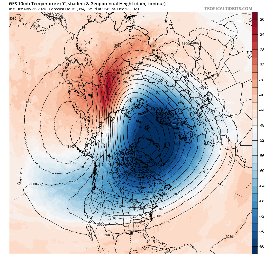
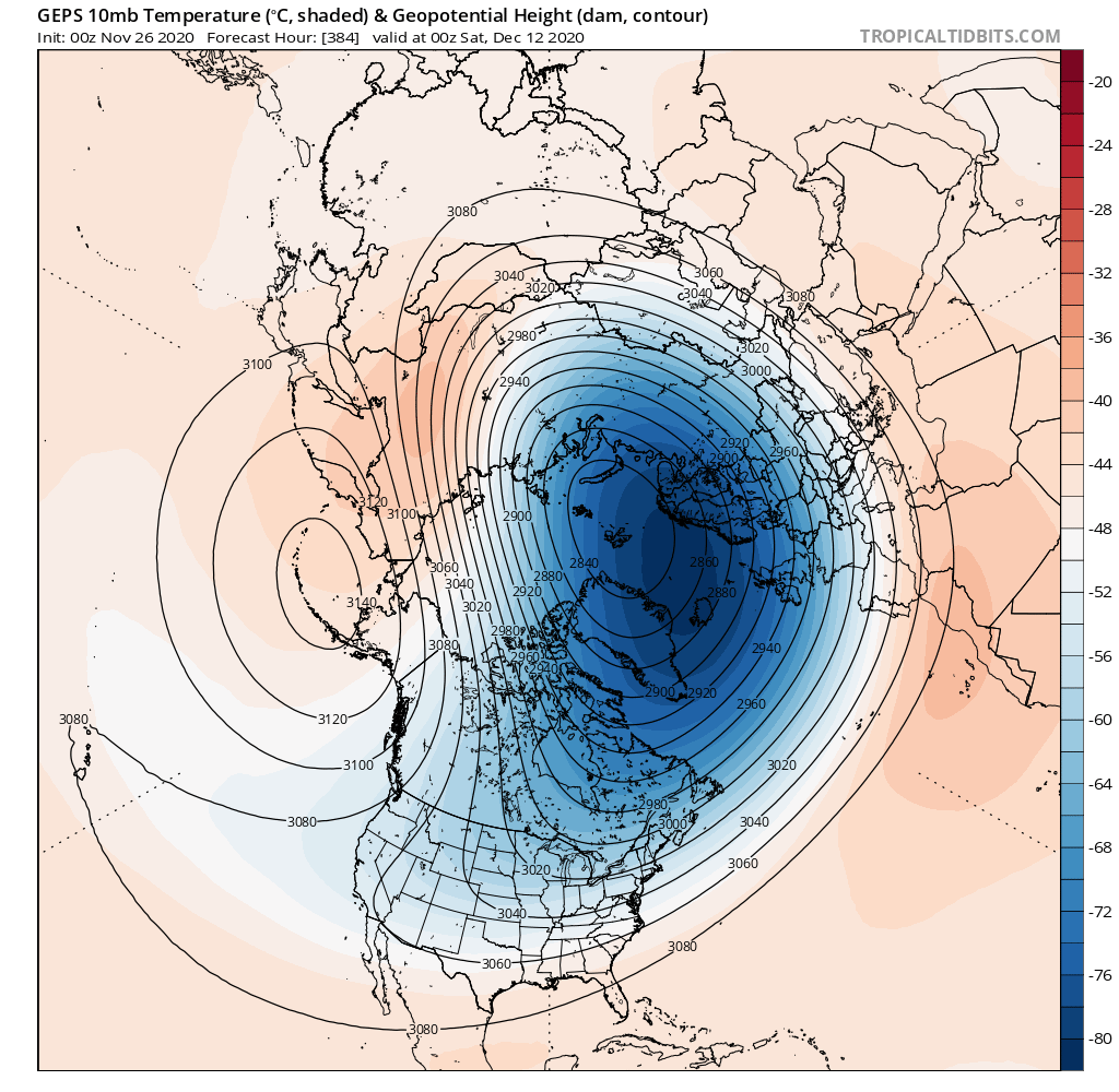
Dr Cohen showing the PV getting knocked around a bit and elongation in Dec. GfS 0Z and 6Z as u can see it getting more elongated and stronger in this depiction. So what does this mean, allowing for cold to overtake
Exciting I must say.and invade Canada and the US. A very good sign if TRUE!
@ALGAE that is great to see and read. Great Pro Mets info there. Hugo is from Britain I believe.
Exciting I must say.and invade Canada and the US. A very good sign if TRUE!


@ALGAE that is great to see and read. Great Pro Mets info there. Hugo is from Britain I believe.
_________________
Mugs
AKA:King: Snow Weenie
Self Proclaimed
WINTER 2014-15 : 55.12" +.02 for 6 coatings (avg. 35")
WINTER 2015-16 Total - 29.8" (Avg 35")
WINTER 2016-17 : 39.5" so far

amugs- Advanced Forecaster - Mod

- Posts : 15147
Reputation : 213
Join date : 2013-01-07
Age : 54
Location : Hillsdale,NJ
 Re: Long Range Discussion 20(20) (Ha!)
Today's 12z GFFS are drool-worthy day 10 to 16 that's an epic pattern if it materializes we will have plenty of snow chances during that time frame let's hope it's not a head fake but haven't seen anything like that in years

algae888- Advanced Forecaster

- Posts : 5311
Reputation : 46
Join date : 2013-02-05
Age : 62
Location : mt. vernon, new york
 Re: Long Range Discussion 20(20) (Ha!)
Happy Thanksgiving, all! I hope everybody had a wonderful holiday! Unfortunately, there are not enough hours in the day, and I didn’t have time for my discussion. Even more regrettably, I won’t be able to get to it until possibly Tuesday. I sincerely apologize for not being able to deliver this when I said I would, but will do my best to make up for it.
As a prelude, though, and building off of my previous posts, here are my concerns:
1. MJO should now begin gaining amplitude through Phases 4-7 as it constructively interferes with a low frequency standing wave that has been established for months in and around the Maritime Continent, which will help to set up an overall unfavorable pattern of lower and upper-level ridging to sustain any cold air and prevent unfavorable storm tracks
2. Equatorial SST anomaly configuration argues against favorable tropical forcing separately from the MJO for sustained cold in eastern North America
3. There is entirely way too much momentum in the mid-latitudes which will continue to influence our pattern by continuously working to eject shortwaves from the Alaskan/Aleutian trough, thereby destructively interfering with any western North American ridge amplification *with a favorable axis orientation* by repeatedly forcing any amplifying ridge to roll over/anticyclonically wavebreak. As a direct consequence, this fits with the above points quite well, and leads to me to even less confidence of any sustained cold/favorable storm tracks, as well as the next point
4. While my understanding of troposphere-stratosphere interactions is still admittedly limited, it seems to me that the wave breaking events are not occurring in prime areas for substantial PV disruption - we’d rather see these events further west and at higher latitudes in the Pacific domain, and at higher latitudes in the Atlantic domain. As current indications suggest to me, what we should see is a general steady-state or slight weakening of the PV, as the the vertical flux from the tropospheric wave breaking only yields glancing blows to the vortex’s periphery. The lack of further strengthening and possible slight degradation from the above would, however, constructively interfere with observed and theoretical effects of the propagating MJO wave through the Maritime Continent, but with a westerly QBO background state, I still think the PV will remain generally unreceptive to these attacks and will likely remain largely intact.
Again, I fully intend to lay these arguments out in detail so they can be demonstrated and visualized, but time is not permitting it right now, and I apologize.
rb924119- Meteorologist

- Posts : 7091
Reputation : 195
Join date : 2013-02-06
Age : 32
Location : Greentown, Pa
 Re: Long Range Discussion 20(20) (Ha!)
Sounds good Ray.
However, there is a lot of model support at this juncture to say with high confidence cold temperatures are going to invade our side of the country beginning mid next week and possibly last the first several days of December. That is a clear pattern change from where we are now. I’m not buying any snow yet, but the +PNA pattern that is modeled will definitely change things up around here.
However, there is a lot of model support at this juncture to say with high confidence cold temperatures are going to invade our side of the country beginning mid next week and possibly last the first several days of December. That is a clear pattern change from where we are now. I’m not buying any snow yet, but the +PNA pattern that is modeled will definitely change things up around here.
_________________
_______________________________________________________________________________________________________
CLICK HERE to view NJ Strong Snowstorm Classifications
 Re: Long Range Discussion 20(20) (Ha!)
Frank_Wx wrote:Sounds good Ray.
However, there is a lot of model support at this juncture to say with high confidence cold temperatures are going to invade our side of the country beginning mid next week and possibly last the first several days of December. That is a clear pattern change from where we are now. I’m not buying any snow yet, but the +PNA pattern that is modeled will definitely change things up around here.
I’m not saying that we won’t see cold shots, but I think the negative temperature anomalies in the time mean will likely end up to be south of the Mason-Dixon, with us averaging near to slightly above average (i.e. somewhere along the lines of 0 to +2, for example). In my opinion, this will be achieved by warm surges as storms ball up to our west and southwest beneath the blocking thereby allowing warm advection to race out in front. Then, as systems drift east-northeastward, likely remaining to our west, they have nothing to work with but stale Maritime air.
rb924119- Meteorologist

- Posts : 7091
Reputation : 195
Join date : 2013-02-06
Age : 32
Location : Greentown, Pa
 Re: Long Range Discussion 20(20) (Ha!)
_________________
_______________________________________________________________________________________________________
CLICK HERE to view NJ Strong Snowstorm Classifications
 Re: Long Range Discussion 20(20) (Ha!)
rb924119 wrote:Frank_Wx wrote:Sounds good Ray.
However, there is a lot of model support at this juncture to say with high confidence cold temperatures are going to invade our side of the country beginning mid next week and possibly last the first several days of December. That is a clear pattern change from where we are now. I’m not buying any snow yet, but the +PNA pattern that is modeled will definitely change things up around here.
I’m not saying that we won’t see cold shots, but I think the negative temperature anomalies in the time mean will likely end up to be south of the Mason-Dixon, with us averaging near to slightly above average (i.e. somewhere along the lines of 0 to +2, for example). In my opinion, this will be achieved by warm surges as storms ball up to our west and southwest beneath the blocking thereby allowing warm advection to race out in front. Then, as systems drift east-northeastward, likely remaining to our west, they have nothing to work with but stale Maritime air.
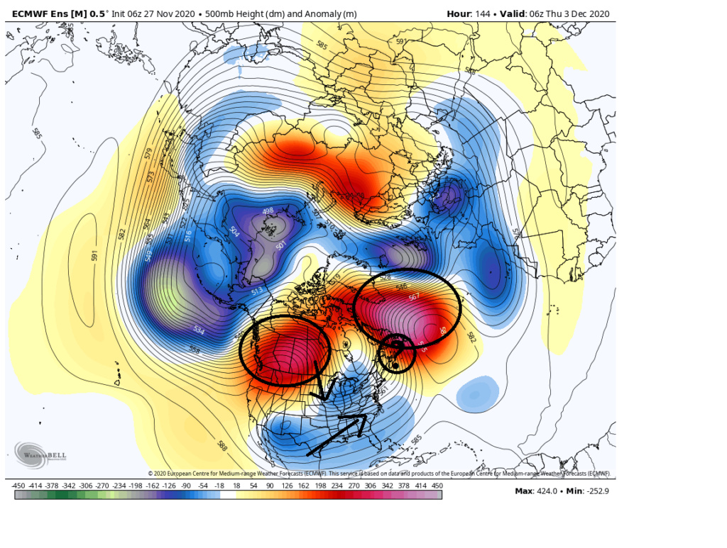
With a +PNA, And bear in mind a bit of a -NAO is showing up in the means, with an initial piece of balled up energy surging NW of the region if there is any enegy left behind, the initial wave may act as a 50/50 low since there def appears to be blocking setting up in the N. Atlantic. As is always the case timing, strength and positioning of key players is everything but if we can get some of the lead energy out in front in the 50/50 region, which isnt out of the question given the current look, and there is energy left behind with the right wave spacing then voila... it's at least a possibility. Best so far anyhow.
The devil is in the details of course. Right now its all just big picture
_________________
"In weather and in life, there's no winning and losing; there's only winning and learning."
WINTER 2012/2013 TOTALS 43.65"WINTER 2017/2018 TOTALS 62.85" WINTER 2022/2023 TOTALS 4.9"
WINTER 2013/2014 TOTALS 64.85"WINTER 2018/2019 TOTALS 14.25" WINTER 2023/2024 TOTALS 13.1"
WINTER 2014/2015 TOTALS 71.20"WINTER 2019/2020 TOTALS 6.35" WINTER 2024/2025 TOTALS 0.00
WINTER 2015/2016 TOTALS 35.00"WINTER 2020/2021 TOTALS 37.75"
WINTER 2016/2017 TOTALS 42.25"WINTER 2021/2022 TOTALS 31.65"

sroc4- Admin

- Posts : 8458
Reputation : 302
Join date : 2013-01-07
Location : Wading River, LI
 Re: Long Range Discussion 20(20) (Ha!)
sroc4 wrote:rb924119 wrote:Frank_Wx wrote:Sounds good Ray.
However, there is a lot of model support at this juncture to say with high confidence cold temperatures are going to invade our side of the country beginning mid next week and possibly last the first several days of December. That is a clear pattern change from where we are now. I’m not buying any snow yet, but the +PNA pattern that is modeled will definitely change things up around here.
I’m not saying that we won’t see cold shots, but I think the negative temperature anomalies in the time mean will likely end up to be south of the Mason-Dixon, with us averaging near to slightly above average (i.e. somewhere along the lines of 0 to +2, for example). In my opinion, this will be achieved by warm surges as storms ball up to our west and southwest beneath the blocking thereby allowing warm advection to race out in front. Then, as systems drift east-northeastward, likely remaining to our west, they have nothing to work with but stale Maritime air.
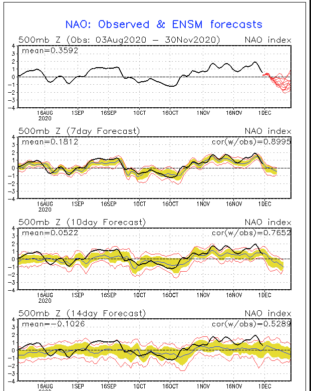
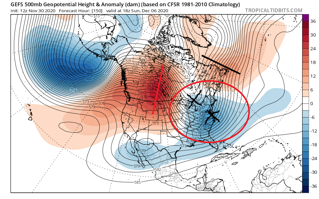
With a +PNA, And bear in mind a bit of a -NAO is showing up in the means, with an initial piece of balled up energy surging NW of the region if there is any enegy left behind, the initial wave may act as a 50/50 low since there def appears to be blocking setting up in the N. Atlantic. As is always the case timing, strength and positioning of key players is everything but if we can get some of the lead energy out in front in the 50/50 region, which isnt out of the question given the current look, and there is energy left behind with the right wave spacing then voila... it's at least a possibility. Best so far anyhow.
The devil is in the details of course. Right now its all just big picture
I’ll grant you that timing is always a key, and you raise a valid point with a possible 50/50 low, look closely, and you’ll find that it’s not really a -NAO. It’s more of an amplified ridge in a zonal pattern. If it was a true -NAO, the axis would be wanting to fold over and pinch off, not stay upright. The difference in this orientation has tremendous implications on our sensible weather. As for the PNA, yes, it’s there, but it’s much less than optimal in my opinion given what continues to go on upstream of it.
rb924119- Meteorologist

- Posts : 7091
Reputation : 195
Join date : 2013-02-06
Age : 32
Location : Greentown, Pa
 Re: Long Range Discussion 20(20) (Ha!)
rb924119 wrote:sroc4 wrote:rb924119 wrote:Frank_Wx wrote:Sounds good Ray.
However, there is a lot of model support at this juncture to say with high confidence cold temperatures are going to invade our side of the country beginning mid next week and possibly last the first several days of December. That is a clear pattern change from where we are now. I’m not buying any snow yet, but the +PNA pattern that is modeled will definitely change things up around here.
I’m not saying that we won’t see cold shots, but I think the negative temperature anomalies in the time mean will likely end up to be south of the Mason-Dixon, with us averaging near to slightly above average (i.e. somewhere along the lines of 0 to +2, for example). In my opinion, this will be achieved by warm surges as storms ball up to our west and southwest beneath the blocking thereby allowing warm advection to race out in front. Then, as systems drift east-northeastward, likely remaining to our west, they have nothing to work with but stale Maritime air.
With a +PNA, And bear in mind a bit of a -NAO is showing up in the means, with an initial piece of balled up energy surging NW of the region if there is any energy left behind, the initial wave may act as a 50/50 low since there def appears to be blocking setting up in the N. Atlantic. As is always the case timing, strength and positioning of key players is everything but if we can get some of the lead energy out in front in the 50/50 region, which isnt out of the question given the current look, and there is energy left behind with the right wave spacing then voila... it's at least a possibility. Best so far anyhow.
The devil is in the details of course. Right now its all just big picture
I’ll grant you that timing is always a key, and you raise a valid point with a possible 50/50 low, look closely, and you’ll find that it’s not really a -NAO. It’s more of an amplified ridge in a zonal pattern. If it was a true -NAO, the axis would be wanting to fold over and pinch off, not stay upright. The difference in this orientation has tremendous implications on our sensible weather. As for the PNA, yes, it’s there, but it’s much less than optimal in my opinion given what continues to go on upstream of it.
Ray, believe me you I hear what your saying. Do not overthink my overall level of enthusiasm here. Hence the verbiage "a bit" of a -NAO, and "the DEVIL is in the details" and "just big picture" for now.
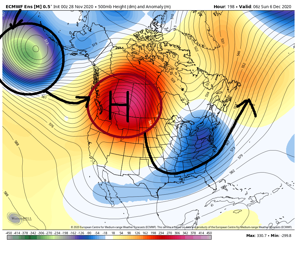
Bottom line is this. IF the early December pattern looked like this........
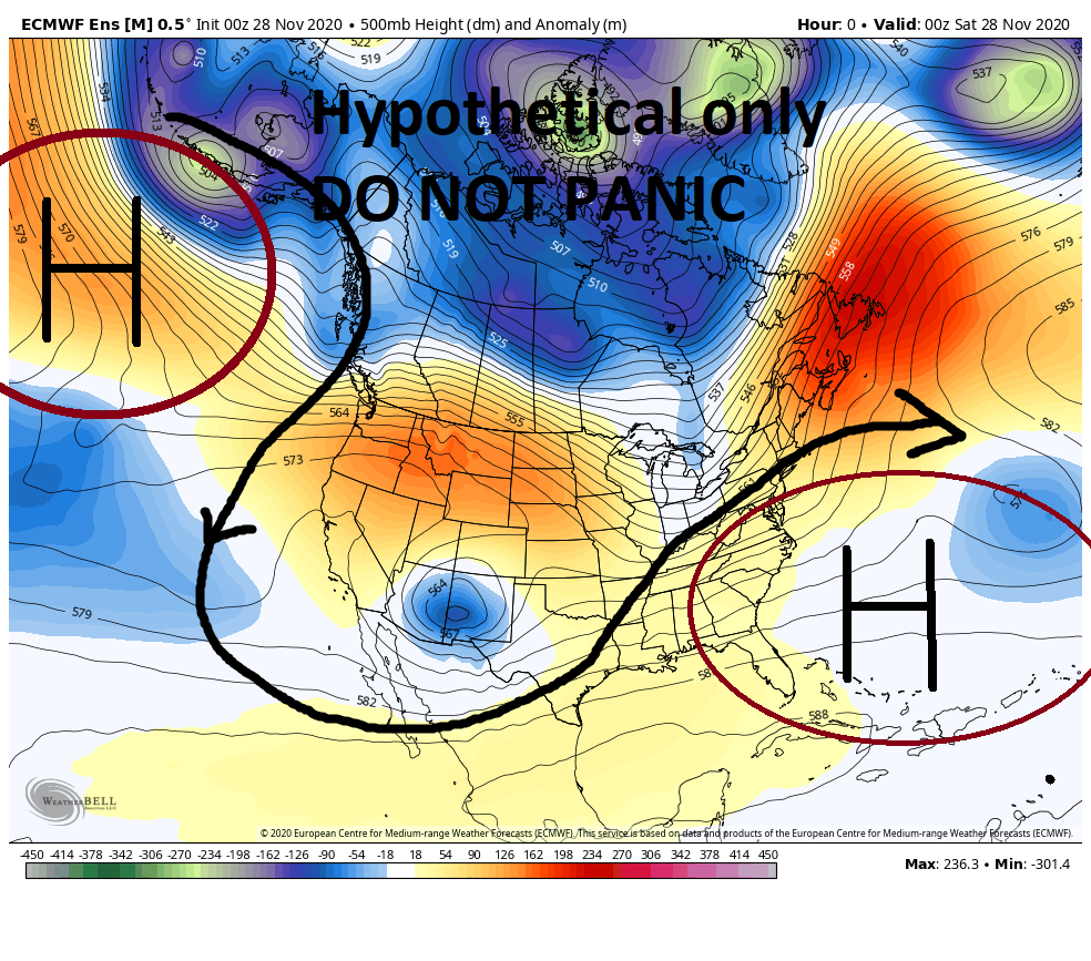
There wouldn't even be a discussion right now. Unless the discussion was about your favorite golf course.
However; when you're talking about 7-10days out the pattern below at least warrants the discussion for "the potential" for cooler temps, and possible white stuff; much more so than the above depicted pattern. Again the "devils in the details" and "just big picture" for now. It may not be perfect but its at least workable when considering its only early December we are talking about.
_________________
"In weather and in life, there's no winning and losing; there's only winning and learning."
WINTER 2012/2013 TOTALS 43.65"WINTER 2017/2018 TOTALS 62.85" WINTER 2022/2023 TOTALS 4.9"
WINTER 2013/2014 TOTALS 64.85"WINTER 2018/2019 TOTALS 14.25" WINTER 2023/2024 TOTALS 13.1"
WINTER 2014/2015 TOTALS 71.20"WINTER 2019/2020 TOTALS 6.35" WINTER 2024/2025 TOTALS 0.00
WINTER 2015/2016 TOTALS 35.00"WINTER 2020/2021 TOTALS 37.75"
WINTER 2016/2017 TOTALS 42.25"WINTER 2021/2022 TOTALS 31.65"

sroc4- Admin

- Posts : 8458
Reputation : 302
Join date : 2013-01-07
Location : Wading River, LI
 Re: Long Range Discussion 20(20) (Ha!)
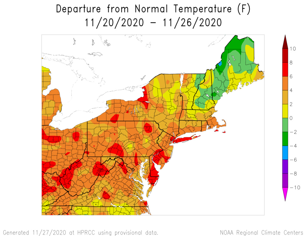
There’s no doubt the absence of blocking in the North Atlantic and Arctic is the reason we’re forecasted to be more wet than white the first 7 days of December. It’s looking like even the storm on December 5th-6th is trending to track similarly to this Monday’s storm - west into PA which floods the coast with warmth. I’ll keep the SCI very low at 5% still but don’t be surprised to see it removed come Monday.
That said, what I’m seeing in the longer range is the potential for low amplitude of high latitude arctic blocking (-AO) to develop. The persistent eastern Pacific ridge that is forecasted to develop will distribute warm air into the Stratosphere, likely purturbing the strat PV and sending arctic air in the polar region down into the eastern portions of the CONUS.
The time frame this would happen is after December 8th, and it wouldn’t shock me to see some models show fantasy snowstorms between the 10th-18th of the month. If the AO does NOT come to fruition, then the mid part of December is likely going to look like the first 7 days, with storms tracking west of our area and bringing rain. I’m not putting much if any faith in the NAO - expect that region to be mostly positive through all of December.
It’s still far far out into the future and a lot will change on models between now and then. Let’s just see how the next week unfolds.
_________________
_______________________________________________________________________________________________________
CLICK HERE to view NJ Strong Snowstorm Classifications
 Re: Long Range Discussion 20(20) (Ha!)
Frank_Wx wrote:Everyone is familiar with Isotherm. Here is his winter outlook. Probably one of the only forecasters I pay most attention to.
https://www.lightinthestorm.com/
His outlook touches on some of the things from my last post. The cold is going to stay bottled up in the Arctic. Wildcard being a SSWE, but likelihood appears very low.
Just seeing this now - many thanks for the kind words, Frank (and to others who responded as well). I realize it has merely been about 3 weeks since I issued the outlook, but at this juncture, I see no compelling reason to depart from the outlook ideas. I expected December to average positive PNA, but with a mostly hostile pattern for sustained cold or snow on the coast most of the month. My progression in the outlook would tend to feature gradual improvement deeper/later in December, and particularly January, with neutralization of the arctic parameters in concert w/ PNA. I know there have been some maps floating around the internet re: weakening of the SPV late in December. I don't assign much value to such model data, but a temporarily weaker or somewhat displaced vortex in January (There is some seasonal & sub-seasonal support for that) would tend to accord with my outlook thoughts re: January offering the best winter opportunities in the Northeast.
sroc4 and rb924119 like this post
 Re: Long Range Discussion 20(20) (Ha!)
Let’s beat these models like they owe us money

dkodgis- Senior Enthusiast

- Posts : 2688
Reputation : 98
Join date : 2013-12-29
amugs likes this post
 Re: Long Range Discussion 20(20) (Ha!)
This would be helpful if we keep teh MJO wave muted - hey if it comes out in 6 we have a warm push but maybe muted since it is a low wave.

Time will tell - lots of perturbations in the atmosphere as we transition into winter.
I think after the 2nd storm we see some flakes on teh backside.

Time will tell - lots of perturbations in the atmosphere as we transition into winter.
I think after the 2nd storm we see some flakes on teh backside.
_________________
Mugs
AKA:King: Snow Weenie
Self Proclaimed
WINTER 2014-15 : 55.12" +.02 for 6 coatings (avg. 35")
WINTER 2015-16 Total - 29.8" (Avg 35")
WINTER 2016-17 : 39.5" so far

amugs- Advanced Forecaster - Mod

- Posts : 15147
Reputation : 213
Join date : 2013-01-07
Age : 54
Location : Hillsdale,NJ
 Re: Long Range Discussion 20(20) (Ha!)
amugs wrote:This would be helpful if we keep teh MJO wave muted - hey if it comes out in 6 we have a warm push but maybe muted since it is a low wave.
Time will tell - lots of perturbations in the atmosphere as we transition into winter.
I think after the 2nd storm we see some flakes on teh backside.
The JMA predicts sinking air returns over the dateline and pushes west by weeks 3 and 4 of December. That likely means bad news for the MJO and our pattern.
_________________
_______________________________________________________________________________________________________
CLICK HERE to view NJ Strong Snowstorm Classifications
heehaw453- Advanced Forecaster

- Posts : 3929
Reputation : 86
Join date : 2014-01-20
Location : Bedminster Township, PA Elevation 600' ASL
 Re: Long Range Discussion 20(20) (Ha!)
_________________
Mugs
AKA:King: Snow Weenie
Self Proclaimed
WINTER 2014-15 : 55.12" +.02 for 6 coatings (avg. 35")
WINTER 2015-16 Total - 29.8" (Avg 35")
WINTER 2016-17 : 39.5" so far

amugs- Advanced Forecaster - Mod

- Posts : 15147
Reputation : 213
Join date : 2013-01-07
Age : 54
Location : Hillsdale,NJ
 Re: Long Range Discussion 20(20) (Ha!)
Yes that is the first period to watch as we move into a more favorable pattern today's ensembles look fantastic on all three major Global models. Haven't seen that look on the eps in a few years. The latest weekly are cold through 20th then turn back to a more Nina look with an Eastern Ridge but something tells me that will be delayed as the polar vortex looks to be weakened and the mjo stays out of the maritime continent could be some interesting times ahead we shall see

algae888- Advanced Forecaster

- Posts : 5311
Reputation : 46
Join date : 2013-02-05
Age : 62
Location : mt. vernon, new york
 Re: Long Range Discussion 20(20) (Ha!)
algae888 wrote:
Yes that is the first period to watch as we move into a more favorable pattern today's ensembles look fantastic on all three major Global models. Haven't seen that look on the eps in a few years. The latest weekly are cold through 20th then turn back to a more Nina look with an Eastern Ridge but something tells me that will be delayed as the polar vortex looks to be weakened and the mjo stays out of the maritime continent could be some interesting times ahead we shall see
Algae _ I said before in post here that this warming over teh top maybe enough to perturb that PV and there is a new chart out showing the 10MB winds declining - I know it is one level BUT it is a good sign for now. These HP over the top will help with this but time will tell.
From BAMWX:
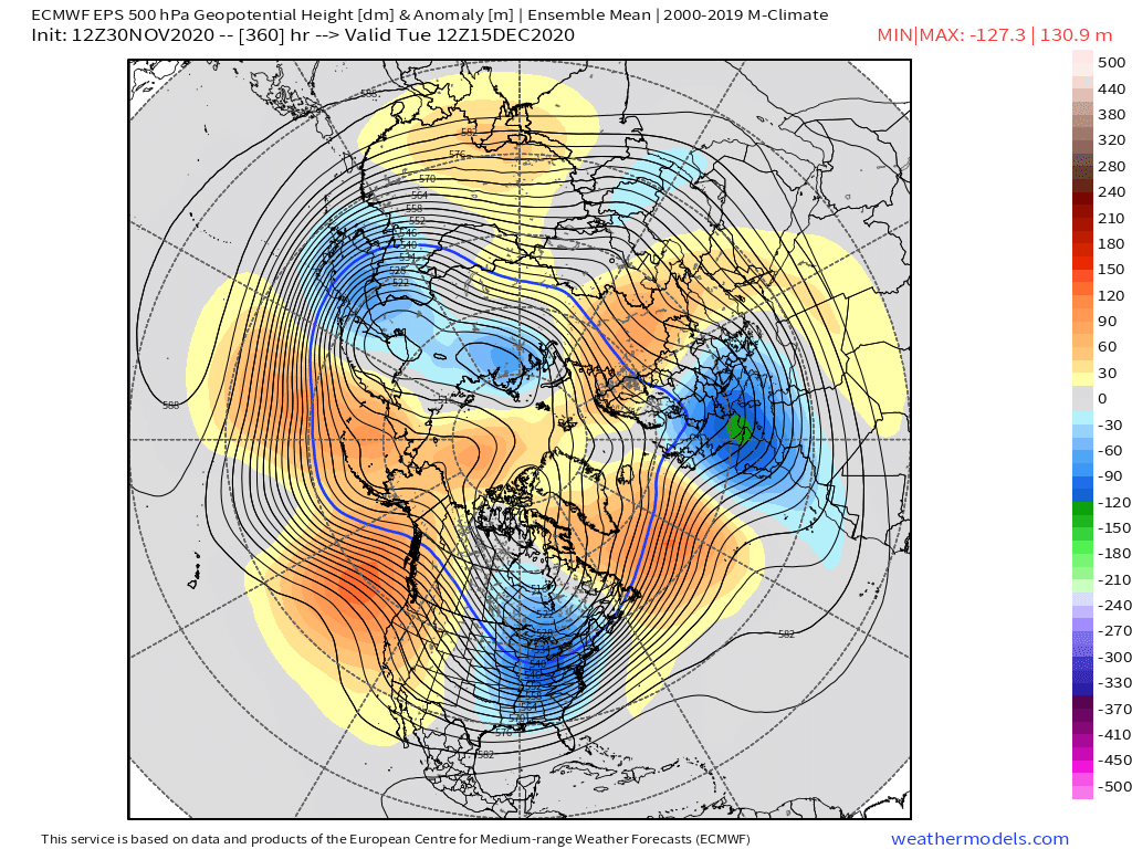
From another board 33&rain
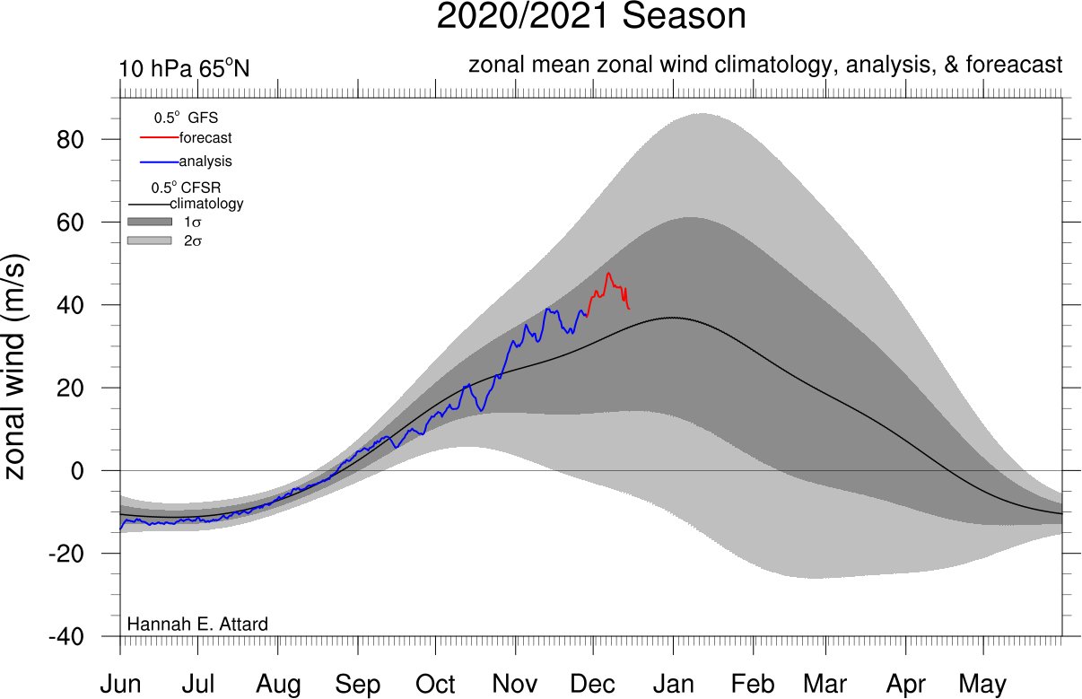
Anthony Masiello Wrote
18z GFS 10mb height and 2 PVU theta forecast through 126h. Watch how the anticyclonic wave break over Scandinavia/Barents teams up with the Aleutian Low pattern to squeeze the vortex all the way up to 10mb.
Guidance in the extended range is rapidly intensifying the Aleutian High in stratosphere/wave 1 configuration.
https://twitter.com/antmasiello/status/1333231500523941888?s=20
_________________
Mugs
AKA:King: Snow Weenie
Self Proclaimed
WINTER 2014-15 : 55.12" +.02 for 6 coatings (avg. 35")
WINTER 2015-16 Total - 29.8" (Avg 35")
WINTER 2016-17 : 39.5" so far

amugs- Advanced Forecaster - Mod

- Posts : 15147
Reputation : 213
Join date : 2013-01-07
Age : 54
Location : Hillsdale,NJ
 Re: Long Range Discussion 20(20) (Ha!)
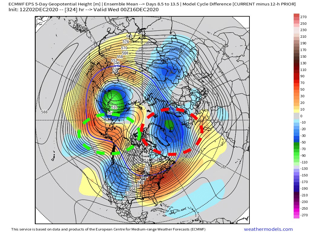
I'll take this in teh means - cold air abound in this pattern as modelled by teh EPS
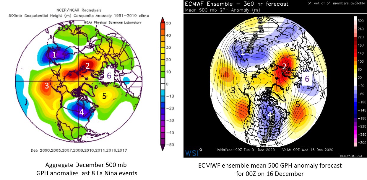

_________________
Mugs
AKA:King: Snow Weenie
Self Proclaimed
WINTER 2014-15 : 55.12" +.02 for 6 coatings (avg. 35")
WINTER 2015-16 Total - 29.8" (Avg 35")
WINTER 2016-17 : 39.5" so far

amugs- Advanced Forecaster - Mod

- Posts : 15147
Reputation : 213
Join date : 2013-01-07
Age : 54
Location : Hillsdale,NJ
 Re: Long Range Discussion 20(20) (Ha!)
Mixed signals in the longer range....
_________________
_______________________________________________________________________________________________________
CLICK HERE to view NJ Strong Snowstorm Classifications
 Re: Long Range Discussion 20(20) (Ha!)
_________________
Mugs
AKA:King: Snow Weenie
Self Proclaimed
WINTER 2014-15 : 55.12" +.02 for 6 coatings (avg. 35")
WINTER 2015-16 Total - 29.8" (Avg 35")
WINTER 2016-17 : 39.5" so far

amugs- Advanced Forecaster - Mod

- Posts : 15147
Reputation : 213
Join date : 2013-01-07
Age : 54
Location : Hillsdale,NJ
 Re: Long Range Discussion 20(20) (Ha!)
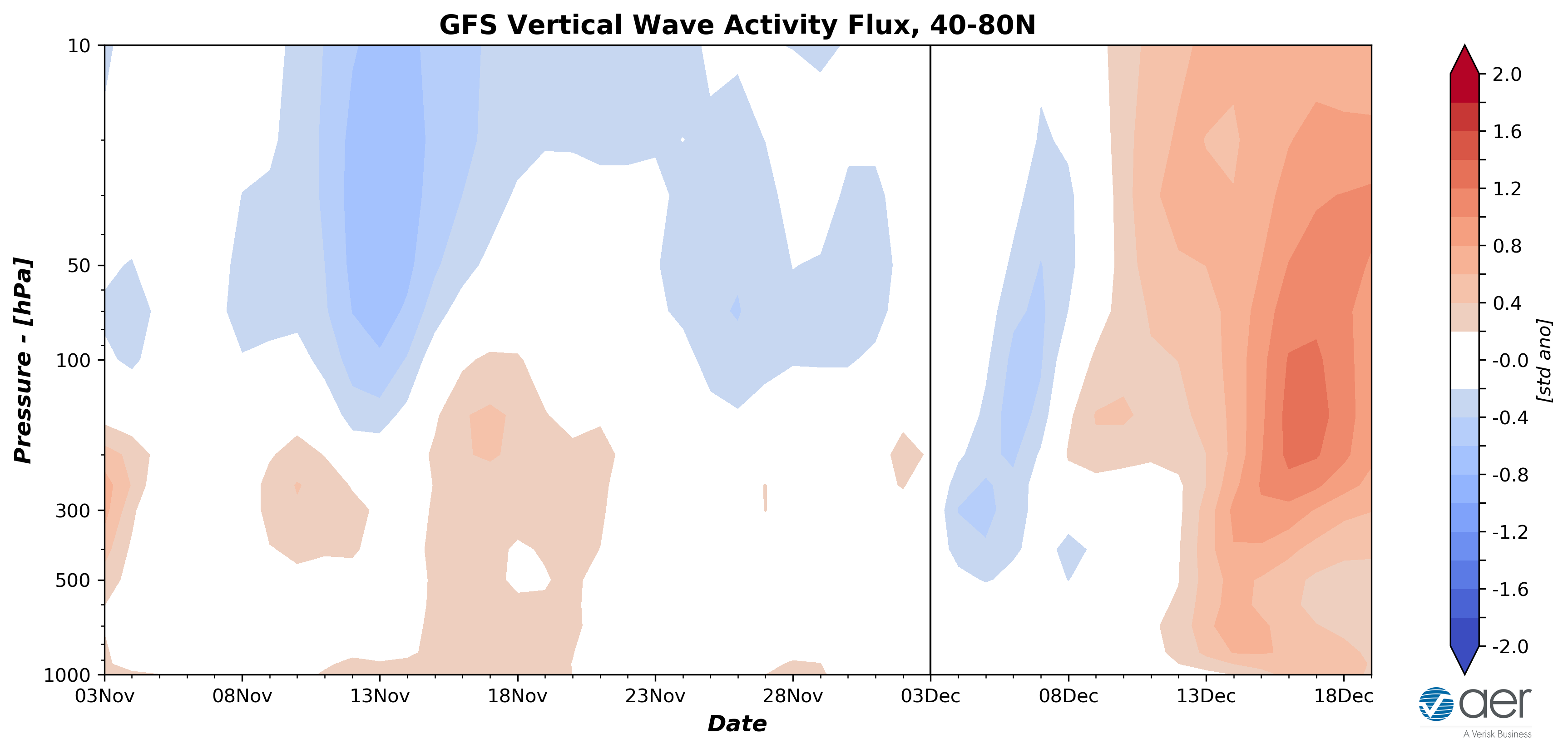
We have a Start Warming event taking place as per the GFS from the EPO heat transport over the Alaska region, longer term colder solution?

_________________
Mugs
AKA:King: Snow Weenie
Self Proclaimed
WINTER 2014-15 : 55.12" +.02 for 6 coatings (avg. 35")
WINTER 2015-16 Total - 29.8" (Avg 35")
WINTER 2016-17 : 39.5" so far

amugs- Advanced Forecaster - Mod

- Posts : 15147
Reputation : 213
Join date : 2013-01-07
Age : 54
Location : Hillsdale,NJ
 Re: Long Range Discussion 20(20) (Ha!)
amugs wrote:We have a Start Warming event taking place as per the GFS from the EPO heat transport over the Alaska region, longer term colder solution?
So here’s my opinion on any **potential** SSW event, and this was ripped from another discussion with a fellow poster, as well as from a post elsewhere:
“....if we can really get the MJO to gain serious amplitude and propagate SLOWLY through the Maritime Continent, that’s a precursor to a true SSW event with favorable alignment (for our region) thanks to the thermodynamics involved. But, we’d have to both take it on the proverbial chin and deal with another torch of a December and probably first half of January AND THEN hope that it’s enough to seriously weaken the anomalously strong stratospheric vortex in a background/QBO state that lessens the overall receptivity to such perturbation. But I think that would really be our best shot at seeing any prolonged winter regime in the eastern CONUS, and have for some time, as at least conceptually, the conditions are mildly decent for the tropospheric evolution.”
With regard to what is being shown on the GFS Op at hour 384, this will likely continue to be mainly overdone, at least for the foreseeable future unless we get a very impressive tropical forcing response for an extended period (i.e. the MJO/standing wave reach 2-sigma or greater deviation for several weeks). IF I start seeing that, again, it’s PLAUSIBLE that this occurs given the likely positive interference that I think will occur between the standing wave and MJO pulse, but I’m not sure if the verified amplitude will be enough given the pre-existing strength of the PV. That said, ANY positive interference between the tropical convective modes will help to weaken it some if it’s sustained long enough. The question is: Would it be enough to give us hope for prolonged winter weather? Without a true SSW, I honestly don’t think so.
P.S. Yes, my other write up is still in the works - I’ve been forced chip away at it rather than blast it out all at once.
rb924119- Meteorologist

- Posts : 7091
Reputation : 195
Join date : 2013-02-06
Age : 32
Location : Greentown, Pa
 Re: Long Range Discussion 20(20) (Ha!)
Looking forward to more long range discussions.
Can someone explain what in blue blazes we need to have a sustained -EPO . With the difference of this years IOD(neutral) and now a moderate LA Nina , why can't the tropical forcing give us a sustained -EPO . I know there's no easy answer, but there has to be something that lends for a more likely -EPO
Can someone explain what in blue blazes we need to have a sustained -EPO . With the difference of this years IOD(neutral) and now a moderate LA Nina , why can't the tropical forcing give us a sustained -EPO . I know there's no easy answer, but there has to be something that lends for a more likely -EPO
Wheezer- Posts : 30
Reputation : 6
Join date : 2017-11-08
Location : Cincinnati, Oh
Page 5 of 30 •  1, 2, 3, 4, 5, 6 ... 17 ... 30
Page 5 of 30
Permissions in this forum:
You cannot reply to topics in this forum
 Home
Home