Long Range Discussion 20(20) (Ha!)
+43
toople
TheAresian
Koroptim
Bkdude
essexcountypete
chief7
GreyBeard
crippo84
hyde345
lglickman1
Zhukov1945
bloc1357
SENJsnowman
Snow88
CPcantmeasuresnow
bobjohnsonforthehall
weatherwatchermom
skinsfan1177
billg315
SoulSingMG
phil155
aiannone
nutleyblizzard
Math23x7
Wheezer
Irish
Frank_Wx
mwilli
Grselig
Isotherm
heehaw453
jimv45
frank 638
docstox12
rb924119
sroc4
HectorO
algae888
dkodgis
Radz
jmanley32
amugs
Dunnzoo
47 posters
Page 26 of 30
Page 26 of 30 •  1 ... 14 ... 25, 26, 27, 28, 29, 30
 Re: Long Range Discussion 20(20) (Ha!)
Well it all comes down to whether anything verifies as always. But the encouraging thing is I remember looking at the models two or three weeks ago and there was nothing of interest for the entire runs. Zippo. Not anything to even get excited about. Actually I’d say in that sense they were right on target because they didn’t show anything interesting and we got nothing interesting. Now at least they are hinting at - or actually showing - activity. That activity may or may not pan out, but it’s better than looking at a two week run with vast nothingness like earlier this month. Lol.
billg315- Advanced Forecaster - Mod

- Posts : 4558
Join date : 2015-01-24
 Re: Long Range Discussion 20(20) (Ha!)
Heck even if I only get 2” of snow Monday, that combined with the 1” I got this past Wednesday morning probably tops last January, not to mention the December storm. So I’ll take this winter over last already.
billg315- Advanced Forecaster - Mod

- Posts : 4558
Join date : 2015-01-24
 Re: Long Range Discussion 20(20) (Ha!)
Heehaw, I have a friend who lives in Glenmore, Pa. i think that is maybe 38 miles from you? He has had a few dustings and a few inches 2x along with one drop of four inches. He is in Chester County. Amazing how some get a bit and some get nothing. Doc and CP in winters past have gotten good snow and at the same time I got bupkis just 25 miles away. I wish we could move around God’s little acre to where the snow is.

dkodgis- Senior Enthusiast

- Posts : 2688
Reputation : 98
Join date : 2013-12-29
 Re: Long Range Discussion 20(20) (Ha!)
dkodgis wrote:Heehaw, I have a friend who lives in Glenmore, Pa. i think that is maybe 38 miles from you? He has had a few dustings and a few inches 2x along with one drop of four inches. He is in Chester County. Amazing how some get a bit and some get nothing. Doc and CP in winters past have gotten good snow and at the same time I got bupkis just 25 miles away. I wish we could move around God’s little acre to where the snow is.
Your friend is about 55-60 miles to my southwest. The elevated parts of Chester County can exceed 850' ASL and those areas probably average close to 40" of snow per year. I'm to the east of Lake Nockamixon at about 600' or so ASL. I average about 35" or so. I was happy with December other than the Grinch Storm of course, but January has been tough on us snow lovers past several years.
But to your point it's amazing how just 50 miles can make all the difference sometimes.
heehaw453- Advanced Forecaster

- Posts : 3931
Reputation : 86
Join date : 2014-01-20
Location : Bedminster Township, PA Elevation 600' ASL
 Re: Long Range Discussion 20(20) (Ha!)
12Z Euro definitely took some steps towards a bigger event. Too late in terms of development, but the 500 mb looks better. Just have to watch it. Shortwave should be coming ashore within next 36 hours or so...
The ridge which blows up the storm is a bit too far east for my liking and of course the TPV lobe is above the trough. If it can just move up or back a bit might be more room for northerly adjustment. Let's see what EPS looks like in a bit...

The ridge which blows up the storm is a bit too far east for my liking and of course the TPV lobe is above the trough. If it can just move up or back a bit might be more room for northerly adjustment. Let's see what EPS looks like in a bit...

heehaw453- Advanced Forecaster

- Posts : 3931
Reputation : 86
Join date : 2014-01-20
Location : Bedminster Township, PA Elevation 600' ASL
 Re: Long Range Discussion 20(20) (Ha!)
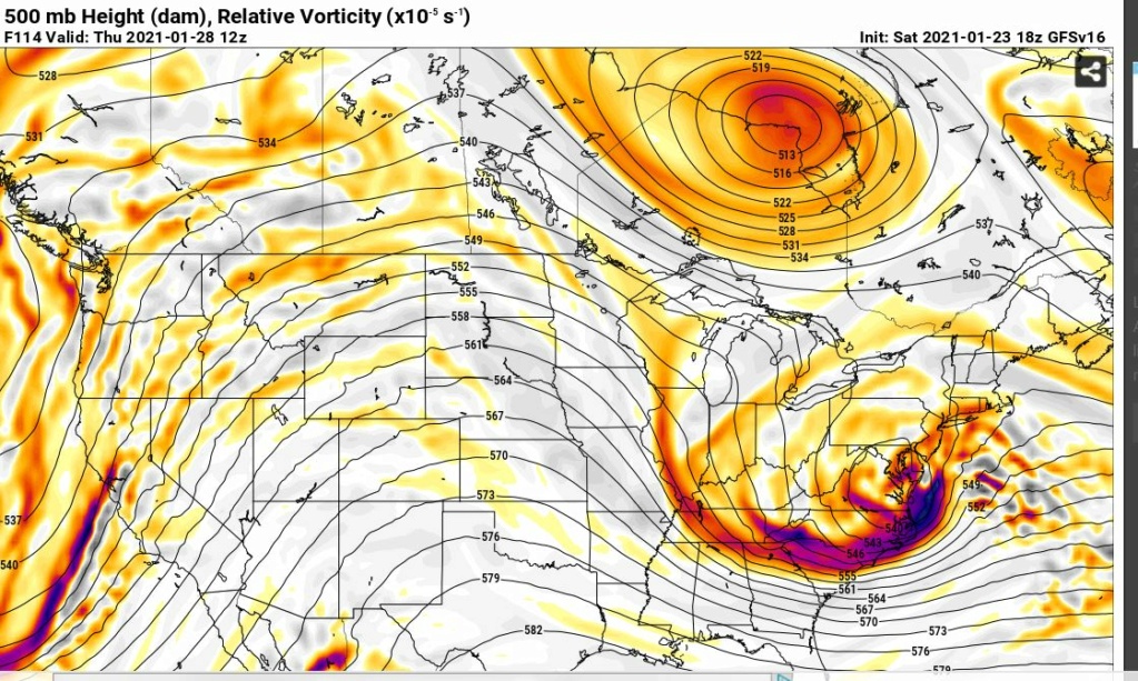
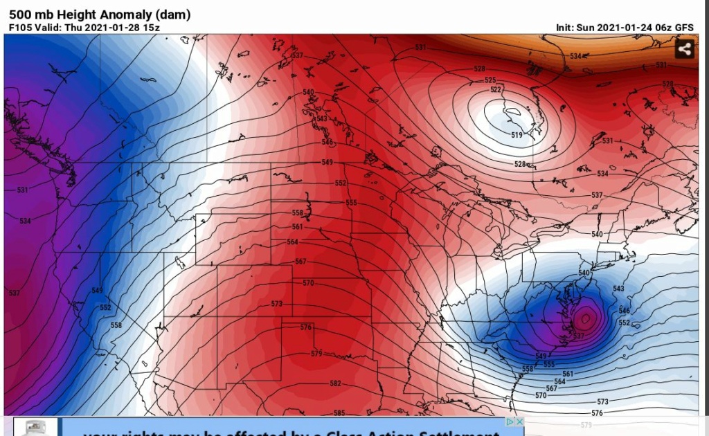
The GFS family still tries to keep Thursday interesting. We have seen many such cases of ULL energy making it much further north than originally modeled as of late. Dunno if that applies to this, but this is damn healthy looking with a closed off ULL underneath us. Basically if the storm can mature and close off like this then we'd be in for something especially if it nudges north. 4+ days out still so who knows...


heehaw453- Advanced Forecaster

- Posts : 3931
Reputation : 86
Join date : 2014-01-20
Location : Bedminster Township, PA Elevation 600' ASL
 Re: Long Range Discussion 20(20) (Ha!)
Pretty consistent with 1/28. GFS and CMC still showing a big storm. If we can get the ULL to exit closer to Ocean City MD instead of VA Beach that'd be pretty big I think. The TPV lobe in Quebec CA will probably make or break this. 4+ days out so adjustments are likely.
As it is now I'd say SE Jersey might be looking good. You guys deserve it down there and pulling for you.
As it is now I'd say SE Jersey might be looking good. You guys deserve it down there and pulling for you.
heehaw453- Advanced Forecaster

- Posts : 3931
Reputation : 86
Join date : 2014-01-20
Location : Bedminster Township, PA Elevation 600' ASL
 Re: Long Range Discussion 20(20) (Ha!)
heehaw453 wrote:Pretty consistent with 1/28. GFS and CMC still showing a big storm. If we can get the ULL to exit closer to Ocean City MD instead of VA Beach that'd be pretty big I think. The TPV lobe in Quebec CA will probably make or break this. 4+ days out so adjustments are likely.
As it is now I'd say SE Jersey might be looking good. You guys deserve it down there and pulling for you.
If I remember correctly, the storm in Jan 26th was modeled to go south of here and than eventually trended north. Do you think the storm in Jan 28th could trend north too or do you think the storm is alot different than the Jan 26th storm?
toople- Posts : 67
Reputation : 0
Join date : 2015-01-01
Location : Nutley, NJ
 Re: Long Range Discussion 20(20) (Ha!)
I think DC to Philly is the bullseye for the Thursday storm, and some models last night came in even more south that would take Philly out of the big snows. Clearly not a good trend for our area. However, we have plenty of board members here from southern NJ and it’s definitely likely they’ll see something from this. We’ll still track it regardless 
_________________
_______________________________________________________________________________________________________
CLICK HERE to view NJ Strong Snowstorm Classifications
larryrock72 likes this post
 Re: Long Range Discussion 20(20) (Ha!)
toople wrote:heehaw453 wrote:Pretty consistent with 1/28. GFS and CMC still showing a big storm. If we can get the ULL to exit closer to Ocean City MD instead of VA Beach that'd be pretty big I think. The TPV lobe in Quebec CA will probably make or break this. 4+ days out so adjustments are likely.
As it is now I'd say SE Jersey might be looking good. You guys deserve it down there and pulling for you.
If I remember correctly, the storm in Jan 26th was modeled to go south of here and than eventually trended north. Do you think the storm in Jan 28th could trend north too or do you think the storm is alot different than the Jan 26th storm?
The GEFS is very consistent about blowing up a big storm that tracks north of VA Beach. At this range and with such consistency I'm starting to believe it. How much precip gets thrown NW of the I95 corridor is tough to say now, but points SE of that towards the Jersey coast are in the game for this one IMO. The Euro is starting to get more inline IMO.
In order for the precip to be more expansive I want to see the trough tilt more negatively and a bit more ridging to the trough west. What you have shown here is a very powerful closed off bomb. When it closes off it can be difficult to predict actually which way it goes as it's more independent. As shown here there is a some room to come up a bit.

heehaw453- Advanced Forecaster

- Posts : 3931
Reputation : 86
Join date : 2014-01-20
Location : Bedminster Township, PA Elevation 600' ASL
larryrock72 likes this post
 Re: Long Range Discussion 20(20) (Ha!)
Frank_Wx wrote:I think DC to Philly is the bullseye for the Thursday storm, and some models last night came in even more south that would take Philly out of the big snows. Clearly not a good trend for our area. However, we have plenty of board members here from southern NJ and it’s definitely likely they’ll see something from this. We’ll still track it regardless
I definitely live in the wrong place for snow. Most times the heavier stuff is N&W of me and most times my area ends up mixing. Then we get the rate occasion where it's cold enough for snow and the storm system stays too far south. Just can't win. Oh well, hope someone gets popped on Thursday. Meanwhile, maybe it's time for me to move to the Caribbean, lol.

Irish- Pro Enthusiast

- Posts : 788
Reputation : 19
Join date : 2019-01-16
Age : 46
Location : Old Bridge, NJ
 Re: Long Range Discussion 20(20) (Ha!)
Irish wrote:Frank_Wx wrote:I think DC to Philly is the bullseye for the Thursday storm, and some models last night came in even more south that would take Philly out of the big snows. Clearly not a good trend for our area. However, we have plenty of board members here from southern NJ and it’s definitely likely they’ll see something from this. We’ll still track it regardless
I definitely live in the wrong place for snow. Most times the heavier stuff is N&W of me and most times my area ends up mixing. Then we get the rate occasion where it's cold enough for snow and the storm system stays too far south. Just can't win. Oh well, hope someone gets popped on Thursday. Meanwhile, maybe it's time for me to move to the Caribbean, lol.
These past 2 winters have been tough. There is no doubt about it. This year stings more as the AO and NAO are favorable but lack of cold air has really hurt us. Last year you just knew there was absolutely no chance so you didn't even have to bother tracking much.
But consider this DC has not had measurable snow in over 1 year! I believe they are days away from breaking a record that has stood for 150 years. So if they get hammered and Philly and NJ coast gets a taste then it's well deserved. At least we had December 17.
heehaw453- Advanced Forecaster

- Posts : 3931
Reputation : 86
Join date : 2014-01-20
Location : Bedminster Township, PA Elevation 600' ASL
 Re: Long Range Discussion 20(20) (Ha!)
Irish, try living in southern ocean county, we really haven't seen anything in 2 years. Lol. It all depends how far north that low with be off Virginia Beach if it could be closer to ocean city Maryland most of this on the be board would be in the game. It's a big jump 125-140 miles north. I hope SENJ snowman is keeping a close eye on this.
larryrock72- Posts : 141
Reputation : 5
Join date : 2017-01-03
Age : 52
Location : Barnegat, NJ
heehaw453 likes this post
 Re: Long Range Discussion 20(20) (Ha!)
Yeah DC and Southern Jersey has definitely been worse. I guess, in my mind though, that's just expected being further south and closer to water.
Last edited by Irish on Sun Jan 24, 2021 8:46 am; edited 1 time in total

Irish- Pro Enthusiast

- Posts : 788
Reputation : 19
Join date : 2019-01-16
Age : 46
Location : Old Bridge, NJ
 Re: Long Range Discussion 20(20) (Ha!)
I’ve mentioned it before but this area is just such a tough area for snow because you have so many variables. We’re blessed to be in a spot where the potential for big snow is often there but cursed by how darn frustrating it can be to get it just right. You have to have just the right track, a perfectly placed/tilted trough, often deal with energy transfers (or fickle Miller B’s), proximity to the warmer ocean and upper level warm air intrusions, as heehaw often mentions we’re right on the fall line. So many factors.
Thursday has big potential it’s just a matter of who jackpots. I could see it trending further north because I think that trend is out there minus this mornings runs. I don’t think we can say anything with certainty on Thursday until the Tuesday system has fully played out and had its impact on the atmosphere.
Thursday has big potential it’s just a matter of who jackpots. I could see it trending further north because I think that trend is out there minus this mornings runs. I don’t think we can say anything with certainty on Thursday until the Tuesday system has fully played out and had its impact on the atmosphere.

billg315- Advanced Forecaster - Mod

- Posts : 4558
Reputation : 185
Join date : 2015-01-24
Age : 50
Location : Flemington, NJ
 Re: Long Range Discussion 20(20) (Ha!)
Larry, I tend to tense up at these times, and hit radio silence. I don’t want to jinx nothing or upset any karmic balance etc...But, I am cautiously optimistic at the moment. The next big moment for me will be how the models react when all the energy is onshore, which I think happens today-ish.
I totally believe in the concept of mean reversion, and I think we at the shore are way on the negative side of the mean for the past 2+ winters, albeit, that follows two Godzillas in a 2 month span in ‘18. Another thing is that every big storm Coastal Ocean gets comes with the same forecast of 1-3 inches from twc, and that’s what we have now, so...that’s a good sign, too! Usually, the forecast is either for mixing or to be out of zone for the heavy snow or both. For Thursday there is no call for mixing. And the models favor a coastal low popping. I’m worried that if that northern trend starts though, it won’t stop and we’ll get another warm side of a storm. Sounds crazy now, but for this winter once that train starts moving north, it’s hard to stop. As the Mon-Tue storm shows.
All I really want is to wake up Thurs am on the cold side of the low, that hasn’t happened around here in a while. And ultimately Irish is 100% correct, Bill too, the shore is a boom or bust snow town and the totality of the factors favor bust far more often than not.
Putting it altogether, only thing I can do is track. And keep my mouth shut... lol!
SENJsnowman- Senior Enthusiast

- Posts : 1199
Reputation : 61
Join date : 2017-01-06
Age : 51
Location : Long Branch, NJ
larryrock72 likes this post
 Re: Long Range Discussion 20(20) (Ha!)
I'm still liking the February 1st threat It's on all operational an ensemble guidance. We will have our coldest air of the season next weekend and then a storm system tries to cut and redevelops along the coast. One thing we are not lacking the next few weeks is systems to track hopefully a few of them will work out for us

algae888- Advanced Forecaster

- Posts : 5311
Reputation : 46
Join date : 2013-02-05
Age : 62
Location : mt. vernon, new york
 Re: Long Range Discussion 20(20) (Ha!)
algae888 wrote:I'm still liking the February 1st threat It's on all operational an ensemble guidance. We will have our coldest air of the season next weekend and then a storm system tries to cut and redevelops along the coast. One thing we are not lacking the next few weeks is systems to track hopefully a few of them will work out for us
I really hope so algae that we can cash in on something. It'd be a pretty bad fail if we can't cash in on something with the favorable Atlantic and arctic and now some cold air in place. Not unprecedented to come out empty handed unfortunately.
heehaw453- Advanced Forecaster

- Posts : 3931
Reputation : 86
Join date : 2014-01-20
Location : Bedminster Township, PA Elevation 600' ASL
 Re: Long Range Discussion 20(20) (Ha!)
I know the 1/31 time period is showing something on the models. But at this point I'll wait another 3 days or so to really look at it.
heehaw453- Advanced Forecaster

- Posts : 3931
Reputation : 86
Join date : 2014-01-20
Location : Bedminster Township, PA Elevation 600' ASL
 Re: Long Range Discussion 20(20) (Ha!)
...and yet Accuweather has a snow accumulation map out today showing me with 3-6 inches for tomorrow. Go figure.
https://dailyvoice.com/new-york/ramapo/weather/here-are-latest-snowfall-projections-new-change-in-time-frame-for-storm-system/801999/?emh=e17f9d52b398447a91c751f64094075eb2cf9591&utm_source=breaking-email-weather-alert&utm_medium=email&utm_campaign=breaking-ramapo-81677
https://dailyvoice.com/new-york/ramapo/weather/here-are-latest-snowfall-projections-new-change-in-time-frame-for-storm-system/801999/?emh=e17f9d52b398447a91c751f64094075eb2cf9591&utm_source=breaking-email-weather-alert&utm_medium=email&utm_campaign=breaking-ramapo-81677

dkodgis- Senior Enthusiast

- Posts : 2688
Reputation : 98
Join date : 2013-12-29
 Re: Long Range Discussion 20(20) (Ha!)
Looks like things might try to warm up to near or over 50 by late next week.

Irish- Pro Enthusiast

- Posts : 788
Reputation : 19
Join date : 2019-01-16
Age : 46
Location : Old Bridge, NJ
 Re: Long Range Discussion 20(20) (Ha!)
The GFS twin which will become the new gf S on February 5th I believe Has snow Sunday evening through Tuesday evening next week. This set up continues to look good with a rising PNA 5050 low and a nao Rising towards neutral with a cold Arctic high over quebec. This is the best setup we've had all Winter except for the December 16th snowstorm.

algae888- Advanced Forecaster

- Posts : 5311
Reputation : 46
Join date : 2013-02-05
Age : 62
Location : mt. vernon, new york
heehaw453- Advanced Forecaster

- Posts : 3931
Reputation : 86
Join date : 2014-01-20
Location : Bedminster Township, PA Elevation 600' ASL
 Re: Long Range Discussion 20(20) (Ha!)
That's basically missing my area and will probably only tend north as we go anyhow. See you in February...
ETA - Right after I type this I check TWC and they dropped the high temps for Sunday- Monday and are now calling for snow with 2-6 inches listed.
Interesting, yet again...
Last edited by Irish on Mon Jan 25, 2021 7:34 pm; edited 1 time in total

Irish- Pro Enthusiast

- Posts : 788
Reputation : 19
Join date : 2019-01-16
Age : 46
Location : Old Bridge, NJ
 Re: Long Range Discussion 20(20) (Ha!)
_________________
Mugs
AKA:King: Snow Weenie
Self Proclaimed
WINTER 2014-15 : 55.12" +.02 for 6 coatings (avg. 35")
WINTER 2015-16 Total - 29.8" (Avg 35")
WINTER 2016-17 : 39.5" so far

amugs- Advanced Forecaster - Mod

- Posts : 15148
Reputation : 213
Join date : 2013-01-07
Age : 54
Location : Hillsdale,NJ
 Re: Long Range Discussion 20(20) (Ha!)
Lol @ "I'm not falling for the banana in the tailpipe again." Great movie reference.
But yes, this 1/31 to 2/1 system does seem to have a more favorable set-up and is beginning to generate some chatter. We'll see how it plays out as the week progresses because I Won't Get Fooled Again.
But yes, this 1/31 to 2/1 system does seem to have a more favorable set-up and is beginning to generate some chatter. We'll see how it plays out as the week progresses because I Won't Get Fooled Again.

billg315- Advanced Forecaster - Mod

- Posts : 4558
Reputation : 185
Join date : 2015-01-24
Age : 50
Location : Flemington, NJ
 Re: Long Range Discussion 20(20) (Ha!)
billg315 wrote:Lol @ "I'm not falling for the banana in the tailpipe again." Great movie reference.
But yes, this 1/31 to 2/1 system does seem to have a more favorable set-up and is beginning to generate some chatter. We'll see how it plays out as the week progresses because I Won't Get Fooled Again.
But do you prefer the banana in the tailpipe?

Irish- Pro Enthusiast

- Posts : 788
Reputation : 19
Join date : 2019-01-16
Age : 46
Location : Old Bridge, NJ
Page 26 of 30 •  1 ... 14 ... 25, 26, 27, 28, 29, 30
Page 26 of 30
Permissions in this forum:
You cannot reply to topics in this forum
 Home
Home

