
 Search
2024 Tropics Season Lets Track!
Page 2 of 8 •  1, 2, 3, 4, 5, 6, 7, 8
 ![]()


sroc4- Admin

- Posts : 8390
Join date : 2013-01-07
Re: 2024 Tropics Season Lets Track!
![]() by sroc4 Mon Jul 01, 2024 7:32 am
by sroc4 Mon Jul 01, 2024 7:32 am


sroc4- Admin
- Posts : 8390
Join date : 2013-01-07
Re: 2024 Tropics Season Lets Track!
![]() by sroc4 Mon Jul 01, 2024 11:58 am
by sroc4 Mon Jul 01, 2024 11:58 am
sroc4 wrote:There is a second low level recon in there as well currently passing through the NE Quad
Beryl down to 950mb. Looks like winds as high as 145-150kts (166-172mph) as it passed over Carriacou, and the couple of smaller islands just to the north. Will be pretty catastrophic down there for sure.
https://www.tropicaltidbits.com/sat/satlooper.php?region=02L&product=vis
_________________
"In weather and in life, there's no winning and losing; there's only winning and learning."
WINTER 2012/2013 TOTALS 43.65"WINTER 2017/2018 TOTALS 62.85" WINTER 2022/2023 TOTALS 4.9"
WINTER 2013/2014 TOTALS 64.85"WINTER 2018/2019 TOTALS 14.25" WINTER 2023/2024 TOTALS 13.1"
WINTER 2014/2015 TOTALS 71.20"WINTER 2019/2020 TOTALS 6.35"
WINTER 2015/2016 TOTALS 35.00"WINTER 2020/2021 TOTALS 37.75"
WINTER 2016/2017 TOTALS 42.25"WINTER 2021/2022 TOTALS 31.65"

sroc4- Admin
- Posts : 8390
Reputation : 302
Join date : 2013-01-07
Location : Wading River, LI
Re: 2024 Tropics Season Lets Track!
![]() by sroc4 Mon Jul 01, 2024 5:25 pm
by sroc4 Mon Jul 01, 2024 5:25 pm
_________________
"In weather and in life, there's no winning and losing; there's only winning and learning."
WINTER 2012/2013 TOTALS 43.65"WINTER 2017/2018 TOTALS 62.85" WINTER 2022/2023 TOTALS 4.9"
WINTER 2013/2014 TOTALS 64.85"WINTER 2018/2019 TOTALS 14.25" WINTER 2023/2024 TOTALS 13.1"
WINTER 2014/2015 TOTALS 71.20"WINTER 2019/2020 TOTALS 6.35"
WINTER 2015/2016 TOTALS 35.00"WINTER 2020/2021 TOTALS 37.75"
WINTER 2016/2017 TOTALS 42.25"WINTER 2021/2022 TOTALS 31.65"
sroc4- Admin
- Posts : 8390
Reputation : 302
Join date : 2013-01-07
Location : Wading River, LI
docstox12 and jmanley32 like this post
Re: 2024 Tropics Season Lets Track!
![]() by jmanley32 Tue Jul 02, 2024 8:23 am
by jmanley32 Tue Jul 02, 2024 8:23 am

jmanley32- Senior Enthusiast

- Posts : 20593
Reputation : 108
Join date : 2013-12-12
Age : 43
Location : Yonkers, NY
Re: 2024 Tropics Season Lets Track!
![]() by jmanley32 Tue Jul 02, 2024 12:17 pm
by jmanley32 Tue Jul 02, 2024 12:17 pm
jmanley32- Senior Enthusiast
- Posts : 20593
Reputation : 108
Join date : 2013-12-12
Age : 43
Location : Yonkers, NY
Re: 2024 Tropics Season Lets Track!
![]() by rb924119 Tue Jul 02, 2024 9:12 pm
by rb924119 Tue Jul 02, 2024 9:12 pm
rb924119- Meteorologist

- Posts : 6995
Reputation : 195
Join date : 2013-02-06
Age : 32
Location : Greentown, Pa
Re: 2024 Tropics Season Lets Track!
![]() by jmanley32 Tue Jul 02, 2024 11:35 pm
by jmanley32 Tue Jul 02, 2024 11:35 pm
hey rb lol I more meant a cat 4 hitting them. Imo even if beryl crosses Yucatan it's going to have some time to refuel.rb924119 wrote:Hey Jman! I didn’t say that I didn’t think it would hit the Yucatán Peninsula, I just said that the one GEM run was showing that, and IF IT WAS A LEGITIMATE OPTION, that it would be bad news for the Gulf Coast. But I haven’t actually provided any opinion on that because I’ve not been looking too closely haha Scott would probably be the better person to ask about the track. As for the hits to Jamaica, I’d imagine that their frequency is relatively high since they are exposed in all three stages of the hurricane season. If I was to guess, I’d say probably a return period of once every 5-7 years or so….?
jmanley32- Senior Enthusiast
- Posts : 20593
Reputation : 108
Join date : 2013-12-12
Age : 43
Location : Yonkers, NY
Re: 2024 Tropics Season Lets Track!
![]() by rb924119 Wed Jul 03, 2024 7:15 am
by rb924119 Wed Jul 03, 2024 7:15 am
rb924119- Meteorologist
- Posts : 6995
Reputation : 195
Join date : 2013-02-06
Age : 32
Location : Greentown, Pa
kalleg likes this post
Re: 2024 Tropics Season Lets Track!
![]() by sroc4 Wed Jul 03, 2024 12:45 pm
by sroc4 Wed Jul 03, 2024 12:45 pm
jmanley32 wrote:hey rb lol I more meant a cat 4 hitting them. Imo even if beryl crosses Yucatan it's going to have some time to refuel.rb924119 wrote:Hey Jman! I didn’t say that I didn’t think it would hit the Yucatán Peninsula, I just said that the one GEM run was showing that, and IF IT WAS A LEGITIMATE OPTION, that it would be bad news for the Gulf Coast. But I haven’t actually provided any opinion on that because I’ve not been looking too closely haha Scott would probably be the better person to ask about the track. As for the hits to Jamaica, I’d imagine that their frequency is relatively high since they are exposed in all three stages of the hurricane season. If I was to guess, I’d say probably a return period of once every 5-7 years or so….?
Here is everything you need to know about historical Tropical systems hitting Jamaica.
https://jis.gov.jm/media/2021/05/History-of-Hurricanes-and-Floods-in-Jamaica.pdf
As far as on the other side of the Yucatan there will be more or less time to "refuel" Beryl depending on exactly just how far N or S he crosses which is still uncertain. And then exactly how far NW the track turns vs WNW is also still uncertain. Many factors in play, first and foremost will be just how much the mountainous terrain disrupts the circulation as t cross Jamaica today. Then we have to see how the upper level TUTT feature out ahead of the system behaves. This is what has weakened him some last night into today. It imparted some vertical shear. Bottom line still alot of intricacies to monitor over the next 5days
_________________
"In weather and in life, there's no winning and losing; there's only winning and learning."
WINTER 2012/2013 TOTALS 43.65"WINTER 2017/2018 TOTALS 62.85" WINTER 2022/2023 TOTALS 4.9"
WINTER 2013/2014 TOTALS 64.85"WINTER 2018/2019 TOTALS 14.25" WINTER 2023/2024 TOTALS 13.1"
WINTER 2014/2015 TOTALS 71.20"WINTER 2019/2020 TOTALS 6.35"
WINTER 2015/2016 TOTALS 35.00"WINTER 2020/2021 TOTALS 37.75"
WINTER 2016/2017 TOTALS 42.25"WINTER 2021/2022 TOTALS 31.65"
sroc4- Admin
- Posts : 8390
Reputation : 302
Join date : 2013-01-07
Location : Wading River, LI
docstox12 and rb924119 like this post
Re: 2024 Tropics Season Lets Track!
![]() by dkodgis Tue Jul 09, 2024 10:32 am
by dkodgis Tue Jul 09, 2024 10:32 am

dkodgis- Senior Enthusiast
- Posts : 2618
Reputation : 98
Join date : 2013-12-29
Re: 2024 Tropics Season Lets Track!
![]() by dkodgis Tue Jul 09, 2024 10:40 am
by dkodgis Tue Jul 09, 2024 10:40 am
dkodgis- Senior Enthusiast
- Posts : 2618
Reputation : 98
Join date : 2013-12-29
Re: 2024 Tropics Season Lets Track!
![]() by billg315 Tue Jul 09, 2024 11:41 am
by billg315 Tue Jul 09, 2024 11:41 am
dkodgis wrote:By this weekend, not that I am smart enough to connect the dots, I see by late Sunday evening and Mon-Tues, lots of rain from Beryl. Does anyone else see heavy, heavy rain coming?
So, at the moment, looks like the bulk of Beryl's remnants will pass well to our west heading into the Great Lakes and then eastern Canada. At the most it could provide a little extra moisture to any thunderstorms that form here late Wednesday into Thursday to enhance the rain, but frankly the atmosphere is so moisture laden right now not sure that will factor much. For the Sunday into Tuesday time period, looks like (slightly) coolER (not "cool" by any means) weather may try to drop down from Canada and with the very hot, humid air in place this weekend that could produce some scattered storms/downpours early next week.

billg315- Advanced Forecaster - Mod

- Posts : 4511
Reputation : 185
Join date : 2015-01-24
Age : 50
Location : Flemington, NJ
weatherwatchermom likes this post
Re: 2024 Tropics Season Lets Track!
![]() by rb924119 Tue Jul 09, 2024 6:20 pm
by rb924119 Tue Jul 09, 2024 6:20 pm
rb924119- Meteorologist
- Posts : 6995
Reputation : 195
Join date : 2013-02-06
Age : 32
Location : Greentown, Pa
sroc4 likes this post
Re: 2024 Tropics Season Lets Track!
![]() by weatherwatchermom Tue Jul 09, 2024 6:40 pm
by weatherwatchermom Tue Jul 09, 2024 6:40 pm
It wasn't that cool up there either..lol I always thought the closer to the border would bring us cooler more comfortable air...every camp ground they complained how unusually hot the weather is..we left Pinecrest campground today(absolutely beautiful place) today I think that was Ulster PA and it was 87*billg315 wrote:dkodgis wrote:By this weekend, not that I am smart enough to connect the dots, I see by late Sunday evening and Mon-Tues, lots of rain from Beryl. Does anyone else see heavy, heavy rain coming?
So, at the moment, looks like the bulk of Beryl's remnants will pass well to our west heading into the Great Lakes and then eastern Canada. At the most it could provide a little extra moisture to any thunderstorms that form here late Wednesday into Thursday to enhance the rain, but frankly the atmosphere is so moisture laden right now not sure that will factor much. For the Sunday into Tuesday time period, looks like (slightly) coolER (not "cool" by any means) weather may try to drop down from Canada and with the very hot, humid air in place this weekend that could produce some scattered storms/downpours early next week.

weatherwatchermom- Senior Enthusiast
- Posts : 3826
Reputation : 78
Join date : 2014-11-25
Location : Hazlet Township, NJ
Re: 2024 Tropics Season Lets Track!
![]() by sroc4 Wed Jul 10, 2024 11:30 am
by sroc4 Wed Jul 10, 2024 11:30 am
sroc4 wrote:sroc4 wrote:weatherwatchermom wrote:dkodgis wrote:Such a beautiful morning...73 now but I see 86 on tap today and it looks like a good dose of rain Thursday. I am waiting for the mid-June warmup and keeping an eye on the Tropics.
Speaking of the tropics saw this today
Important to point out te difference between hype and reality. And mom please dont take this as a knock on your post.
Id like to make a few points. First: nothing is boiling. The Caribbean as a whole is sitting about 1*C above Avg (between about 84-86*F or 29-30*C); keeping in mind avg is created by averaging routine above and below the "avg" value year after year, decade after decade.
Second point:
These temps DO NOT go down 300 feet! Any significant storm WILL cause up welling in its wake the extent of which is yet to be determined.
Third: SST is only one of MANY factors in determining IF a trop storm will develop, strengthen or weaken despite how warm the water is beneath it.
In here throughout the tropical season regardless of how many named storms there are, let us remain level headed and not bring in unproven narratives cloaked as truths. Instead lets focus on what is actually happening in front of us.


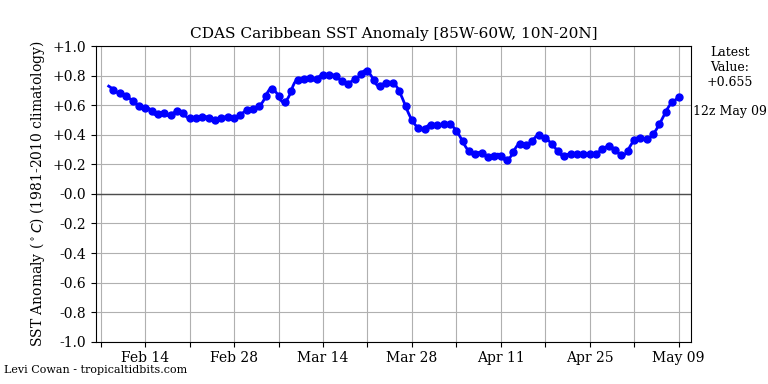
Since there is a lull, figured now would be a great time to bring this post back up from Jun5th. When speaking in hyperbole you often get exposed for pushing a narrative or exposing your bias'. Now truth be told I am certainly guilty of this at times as well, but lets pointy out a couple of things.
Not only did Beryl pass right through the "..ungodly scorching hot...boiling..." water temps of the Caribbean, but it actually weakened as it did so. On top of that it did in fact cause upwelling such that there has been considerable cooling in its wake. Below are the current water temps. Beryl's track is pretty much telegraphed by the shift to cooler than normal SSTA. And as you can see by the maps below and the graph above from the prev post, the Caribbean as a whole is now down to only about 0.5*c above normal. Obv a long way to go in the trop season and a lull in trop activity could lead to temps in the Caribbean and MDR(which are below normal between the African Coast and the Lesser Antilles') to warm back up.


_________________
"In weather and in life, there's no winning and losing; there's only winning and learning."
WINTER 2012/2013 TOTALS 43.65"WINTER 2017/2018 TOTALS 62.85" WINTER 2022/2023 TOTALS 4.9"
WINTER 2013/2014 TOTALS 64.85"WINTER 2018/2019 TOTALS 14.25" WINTER 2023/2024 TOTALS 13.1"
WINTER 2014/2015 TOTALS 71.20"WINTER 2019/2020 TOTALS 6.35"
WINTER 2015/2016 TOTALS 35.00"WINTER 2020/2021 TOTALS 37.75"
WINTER 2016/2017 TOTALS 42.25"WINTER 2021/2022 TOTALS 31.65"
sroc4- Admin
- Posts : 8390
Reputation : 302
Join date : 2013-01-07
Location : Wading River, LI
docstox12 and rb924119 like this post
Re: 2024 Tropics Season Lets Track!
![]() by docstox12 Wed Jul 10, 2024 3:08 pm
by docstox12 Wed Jul 10, 2024 3:08 pm

docstox12- Wx Statistician Guru

- Posts : 8557
Reputation : 222
Join date : 2013-01-07
Age : 73
Location : Monroe NY
sroc4 likes this post
Re: 2024 Tropics Season Lets Track!
![]() by Dunnzoo Wed Jul 10, 2024 3:38 pm
by Dunnzoo Wed Jul 10, 2024 3:38 pm
weatherwatchermom wrote:It wasn't that cool up there either..lol I always thought the closer to the border would bring us cooler more comfortable air...every camp ground they complained how unusually hot the weather is..we left Pinecrest campground today(absolutely beautiful place) today I think that was Ulster PA and it was 87*billg315 wrote:dkodgis wrote:By this weekend, not that I am smart enough to connect the dots, I see by late Sunday evening and Mon-Tues, lots of rain from Beryl. Does anyone else see heavy, heavy rain coming?
So, at the moment, looks like the bulk of Beryl's remnants will pass well to our west heading into the Great Lakes and then eastern Canada. At the most it could provide a little extra moisture to any thunderstorms that form here late Wednesday into Thursday to enhance the rain, but frankly the atmosphere is so moisture laden right now not sure that will factor much. For the Sunday into Tuesday time period, looks like (slightly) coolER (not "cool" by any means) weather may try to drop down from Canada and with the very hot, humid air in place this weekend that could produce some scattered storms/downpours early next week...we only had one cold night in old forge NY and then back to hot..
Mom,
Hope you guys are ok up there! terrible storms rolling through NYS! Please check in and let us know how you made out!
_________________
Janet
Snowfall winter of 2023-2024 17.5"
Snowfall winter of 2022-2023 6.0"
Snowfall winter of 2021-2022 17.6" 1" sleet 2/25/22
Snowfall winter of 2020-2021 51.1"
Snowfall winter of 2019-2020 8.5"
Snowfall winter of 2018-2019 25.1"
Snowfall winter of 2017-2018 51.9"
Snowfall winter of 2016-2017 45.6"
Snowfall winter of 2015-2016 29.5"
Snowfall winter of 2014-2015 50.55"
Snowfall winter of 2013-2014 66.5"

Dunnzoo- Senior Enthusiast - Mod
- Posts : 4910
Reputation : 68
Join date : 2013-01-11
Age : 62
Location : Westwood, NJ
weatherwatchermom likes this post
Re: 2024 Tropics Season Lets Track!
![]() by weatherwatchermom Wed Jul 10, 2024 6:37 pm
by weatherwatchermom Wed Jul 10, 2024 6:37 pm
Dunnzoo wrote:weatherwatchermom wrote:It wasn't that cool up there either..lol I always thought the closer to the border would bring us cooler more comfortable air...every camp ground they complained how unusually hot the weather is..we left Pinecrest campground today(absolutely beautiful place) today I think that was Ulster PA and it was 87*billg315 wrote:dkodgis wrote:By this weekend, not that I am smart enough to connect the dots, I see by late Sunday evening and Mon-Tues, lots of rain from Beryl. Does anyone else see heavy, heavy rain coming?
So, at the moment, looks like the bulk of Beryl's remnants will pass well to our west heading into the Great Lakes and then eastern Canada. At the most it could provide a little extra moisture to any thunderstorms that form here late Wednesday into Thursday to enhance the rain, but frankly the atmosphere is so moisture laden right now not sure that will factor much. For the Sunday into Tuesday time period, looks like (slightly) coolER (not "cool" by any means) weather may try to drop down from Canada and with the very hot, humid air in place this weekend that could produce some scattered storms/downpours early next week.
Mom,
Hope you guys are ok up there! terrible storms rolling through NYS! Please check in and let us know how you made out!
Thank you,
we are good and got home last night..we would have been smack in the middle of it if we were there still..glad we did not extend..but home to tons of laundry..lol Thank you for thinking of us..what a beautiful trip we had I will post pictures when I get a chance.
At 614 PM EDT, a severe thunderstorm was located over South Branch, or 8 miles south of Towanda, moving northeast at 30 mph.
HAZARD...60 mph wind gusts and quarter size hail.
SOURCE...Radar indicated.
IMPACT...Hail damage to vehicles is expected. Expect wind damage to roofs, siding, and trees.
Locations impacted include... Rush, Towanda, Wysox, Dimock, Orwell, North Towanda, Herrick, Wyalusing, Monroe, and Rome.
PRECAUTIONARY/PREPAREDNESS ACTIONS...
Remain alert for a possible tornado! Tornadoes can develop quickly from severe thunderstorms. If you spot a tornado go at once into the basement or small central room in a sturdy structure.
For your protection move to an interior room on the lowest floor of a building.
A Tornado Watch remains in effect until 900 PM EDT for northeastern Pennsylvania.
TORNADO...POSSIBLE; HAIL THREAT...RADAR INDICATED; MAX HAIL SIZE...1.00 IN; WIND THREAT...RADAR INDICATED; MAX WIND GUST...60 MPH
This is where we were!!
weatherwatchermom- Senior Enthusiast
- Posts : 3826
Reputation : 78
Join date : 2014-11-25
Location : Hazlet Township, NJ
Re: 2024 Tropics Season Lets Track!
![]() by rb924119 Thu Jul 11, 2024 10:24 pm
by rb924119 Thu Jul 11, 2024 10:24 pm
rb924119 wrote:We may have something to track for ourselves during the last 7-10 days of July......
This is gaining momentum, in my opinion. Watch for models like the GFS and EURO Control to start picking up on this idea over the coming days. Preliminary track idea would be something that comes off Africa, has that classic slow west then west-northwestward movement as it gets closer, aimed at the Southeast Coast. Then, as it gets within, say, 100-250 miles makes a sharp bend back out to sea/parallel or quartering away from the Carolina Coasts, but then makes a northward turn toward New England. From there, the possibilities would diverge. Climatology would suggest a subsequent curve back out to sea, but I am not so sure it's that easy, and worry at least a partial bend back toward the Northeast Coast would be possible late. I don't think that it would be an overly strong system, but I can see a tropical storm or even category 1 as its peak intensity.
Please keep in mind that this is all extremely preliminary, but I feel that it's enough of a potential threat for me to point it out at this time. We will see how this evolves, but here's a quick rendition of my above thoughts:

rb924119- Meteorologist
- Posts : 6995
Reputation : 195
Join date : 2013-02-06
Age : 32
Location : Greentown, Pa
Re: 2024 Tropics Season Lets Track!
![]() by jmanley32 Thu Jul 11, 2024 11:14 pm
by jmanley32 Thu Jul 11, 2024 11:14 pm
How is this gaining momentum? How can we see that far out even GFS fantasyland does not go that far out. Where are your exclusive past 384 hr maps found lol. Curious as to what makes you think something will even develop off africa in that time frame, let alone steer up EC (very preliminarily of course).rb924119 wrote:rb924119 wrote:We may have something to track for ourselves during the last 7-10 days of July......
This is gaining momentum, in my opinion. Watch for models like the GFS and EURO Control to start picking up on this idea over the coming days. Preliminary track idea would be something that comes off Africa, has that classic slow west then west-northwestward movement as it gets closer, aimed at the Southeast Coast. Then, as it gets within, say, 100-250 miles makes a sharp bend back out to sea/parallel or quartering away from the Carolina Coasts, but then makes a northward turn toward New England. From there, the possibilities would diverge. Climatology would suggest a subsequent curve back out to sea, but I am not so sure it's that easy, and worry at least a partial bend back toward the Northeast Coast would be possible late. I don't think that it would be an overly strong system, but I can see a tropical storm or even category 1 as its peak intensity.
Please keep in mind that this is all extremely preliminary, but I feel that it's enough of a potential threat for me to point it out at this time. We will see how this evolves, but here's a quick rendition of my above thoughts:
jmanley32- Senior Enthusiast
- Posts : 20593
Reputation : 108
Join date : 2013-12-12
Age : 43
Location : Yonkers, NY
Re: 2024 Tropics Season Lets Track!
![]() by rb924119 Fri Jul 12, 2024 12:08 am
by rb924119 Fri Jul 12, 2024 12:08 am
jmanley32 wrote:How is this gaining momentum? How can we see that far out even GFS fantasyland does not go that far out. Where are your exclusive past 384 hr maps found lol. Curious as to what makes you think something will even develop off africa in that time frame, let alone steer up EC (very preliminarily of course).rb924119 wrote:rb924119 wrote:We may have something to track for ourselves during the last 7-10 days of July......
This is gaining momentum, in my opinion. Watch for models like the GFS and EURO Control to start picking up on this idea over the coming days. Preliminary track idea would be something that comes off Africa, has that classic slow west then west-northwestward movement as it gets closer, aimed at the Southeast Coast. Then, as it gets within, say, 100-250 miles makes a sharp bend back out to sea/parallel or quartering away from the Carolina Coasts, but then makes a northward turn toward New England. From there, the possibilities would diverge. Climatology would suggest a subsequent curve back out to sea, but I am not so sure it's that easy, and worry at least a partial bend back toward the Northeast Coast would be possible late. I don't think that it would be an overly strong system, but I can see a tropical storm or even category 1 as its peak intensity.
Please keep in mind that this is all extremely preliminary, but I feel that it's enough of a potential threat for me to point it out at this time. We will see how this evolves, but here's a quick rendition of my above thoughts:
I am just looking at the evolution of the pattern, Jman, both in the Northern Hemisphere and in the tropics, and it is only my opinion that the idea is gaining momentum based on what I am seeing haha Secondly, the GFS and all of the ensembles get into the first few days of the period of interest (last 7-10 days means from the 20th of July onward, which is only 9 days out, and well within the temporal range of medium-range guidance). Lastly, I think it would most likely remain an open wave until it got to around 60W longitude, basically until it reaches the longitude of the Antilles/northeaster Caribbean, though I think it would stay to the north of those islands.
What I am seeing is the following:
1. Northern Hemispheric pattern that is progressive, but supports an anomalous trough digging into the eastern/southeastern CONUS thanks to an anomalous ridge that builds into central Canada/western shore of Hudson Bay. This also allows surface high pressure to build across the northern and northeastern U.S. (think of things that we look for in the Winter, this is a classic sign!)
2. Due to the progressiveness of the pattern, the above trough gets cut off from the mean flow and remains positively tilted while it slowly fades over the eastern/southeastern U.S., and also sets up a west-east elongated ridge across northern New England, southern Canada and the Northwestern Atlantic (what I will call a "Poor man's Newfoundland Wheel")
3. The presence of this trough/ridge orientation is supported by two things: 1) What should be a pretty stout downturn in the SOI over the next week or so, which tends to correlate with troughing over the eastern/southeastern CONUS, and 2) attempt of a MJO pulse to emerge in Phase 5 or 6, which correlates with a trough in the same area during this time of year with ridging over the top.
4. A sharp increase of the SST anomalies in Niño region 1.2 over the last few weeks well in excess of the 1ºC threshold that I like to use, which corresponds to ridging over the eastern CONUS 2-3 weeks later, and supports the idea of the central Canadian ridge toppling eastward over the trough in the progressive pattern.
5. A signature of upper-level divergence favorably located over the Atlantic Basin, albeit relatively weak, but with the presence of the trough over the southeastern U.S., and surface high pressure to the north, this is why I can see development later in the game as it comes into an area with better low-level inflow and more venting aloft (though asymmetric). Remember, the weaker a system is to start, the relatively fewer things it needs to start gaining mild levels of strength relative to what it was before.
Initially, the Atlantic ridge will continue to steer the wave briskly to the west-northwest, but as the trough settles into the eastern and southeastern CONUS and the higher-latitude ridge progresses above it, I think a window will open on the western flank of the Atlantic ridge just as the wave is approaching ~60W, which allow it to start to turn more northward before actually coming ashore in the southeastern U.S.. Initially, it will try to recurve, but my fear is that the trough will be strong enough not only enhance the development of the wave a bit, but also interact with it to some degree, which is where I am getting my idea of the possibility of a due north track, or even a track slightly west of that. Keep in mind, not only will it possibly be affected by the trough, but as that ridge comes across northern New England and southeastern Canada, that will also start to impart a resistance to the climatological recurve and southwesterly steering flow downstream of the trough.
This is all preliminary, Jman, so I'm not sounding the alarms to batten down all the hatches yet, but I do think that this is a legitimate possibility at this time, that's all. I can probably do a video over the weekend to better demonstrate this idea in real time if I feel that it's still warranted haha
rb924119- Meteorologist
- Posts : 6995
Reputation : 195
Join date : 2013-02-06
Age : 32
Location : Greentown, Pa
sroc4, docstox12, jmanley32 and weatherwatchermom like this post
Re: 2024 Tropics Season Lets Track!
![]() by sroc4 Fri Jul 12, 2024 8:10 am
by sroc4 Fri Jul 12, 2024 8:10 am
_________________
"In weather and in life, there's no winning and losing; there's only winning and learning."
WINTER 2012/2013 TOTALS 43.65"WINTER 2017/2018 TOTALS 62.85" WINTER 2022/2023 TOTALS 4.9"
WINTER 2013/2014 TOTALS 64.85"WINTER 2018/2019 TOTALS 14.25" WINTER 2023/2024 TOTALS 13.1"
WINTER 2014/2015 TOTALS 71.20"WINTER 2019/2020 TOTALS 6.35"
WINTER 2015/2016 TOTALS 35.00"WINTER 2020/2021 TOTALS 37.75"
WINTER 2016/2017 TOTALS 42.25"WINTER 2021/2022 TOTALS 31.65"
sroc4- Admin
- Posts : 8390
Reputation : 302
Join date : 2013-01-07
Location : Wading River, LI
rb924119 and weatherwatchermom like this post
Re: 2024 Tropics Season Lets Track!
![]() by Dunnzoo Tue Jul 16, 2024 1:49 pm
by Dunnzoo Tue Jul 16, 2024 1:49 pm
_________________
Janet
Snowfall winter of 2023-2024 17.5"
Snowfall winter of 2022-2023 6.0"
Snowfall winter of 2021-2022 17.6" 1" sleet 2/25/22
Snowfall winter of 2020-2021 51.1"
Snowfall winter of 2019-2020 8.5"
Snowfall winter of 2018-2019 25.1"
Snowfall winter of 2017-2018 51.9"
Snowfall winter of 2016-2017 45.6"
Snowfall winter of 2015-2016 29.5"
Snowfall winter of 2014-2015 50.55"
Snowfall winter of 2013-2014 66.5"
Dunnzoo- Senior Enthusiast - Mod
- Posts : 4910
Reputation : 68
Join date : 2013-01-11
Age : 62
Location : Westwood, NJ
weatherwatchermom likes this post
Re: 2024 Tropics Season Lets Track!
![]() by dkodgis Tue Jul 16, 2024 1:51 pm
by dkodgis Tue Jul 16, 2024 1:51 pm
dkodgis- Senior Enthusiast
- Posts : 2618
Reputation : 98
Join date : 2013-12-29
weatherwatchermom likes this post
Re: 2024 Tropics Season Lets Track!
![]() by rb924119 Wed Jul 17, 2024 1:58 pm
by rb924119 Wed Jul 17, 2024 1:58 pm
Dunnzoo wrote:Thanks Ray, but what about the Saharan dust blowing across the Atlantic? Do you see that decreasing in this time frame you are looking at?
I don't think it would be a factor in the sense that I don't think that the pattern will support much development before (east of) 60W longitude anyway. If something does develop, it will be much closer to the U.S. East Coast, and by that point, the impact of the dust/dry air will be pretty well mixed out and mitigated.
rb924119- Meteorologist
- Posts : 6995
Reputation : 195
Join date : 2013-02-06
Age : 32
Location : Greentown, Pa
Dunnzoo and weatherwatchermom like this post
Re: 2024 Tropics Season Lets Track!
![]() by rb924119 Wed Jul 17, 2024 1:59 pm
by rb924119 Wed Jul 17, 2024 1:59 pm
rb924119- Meteorologist
- Posts : 6995
Reputation : 195
Join date : 2013-02-06
Age : 32
Location : Greentown, Pa
Dunnzoo and weatherwatchermom like this post
Page 2 of 8 • 1, 2, 3, 4, 5, 6, 7, 8 ![]()
|
|
|