Long Range Thread 16.0
+53
dad4twoboys
toople
Aiosamoney21
Vinnydula
jimv45
petep10
Taffy
lglickman1
mikeypizano
SNOW MAN
Sanchize06
devsman
Nyi1058
mwilli5783
Sparky Sparticles
Smittyaj623
adamfitz1969
essexcountypete
weatherwatchermom
rb924119
oldtimer
sabamfa
Radz
GreyBeard
Scullybutcher
SnowForest
dkodgis
WeatherBob
Carter bk
Math23x7
SENJsnowman
RJB8525
Quietace
nutleyblizzard
docstox12
NjWeatherGuy
Dunnzoo
frank 638
jmanley32
billg315
skinsfan1177
SoulSingMG
Grselig
aiannone
algae888
Snow88
sroc4
MattyICE
Frank_Wx
crippo84
CPcantmeasuresnow
track17
amugs
57 posters
Page 15 of 34
Page 15 of 34 •  1 ... 9 ... 14, 15, 16 ... 24 ... 34
 Re: Long Range Thread 16.0
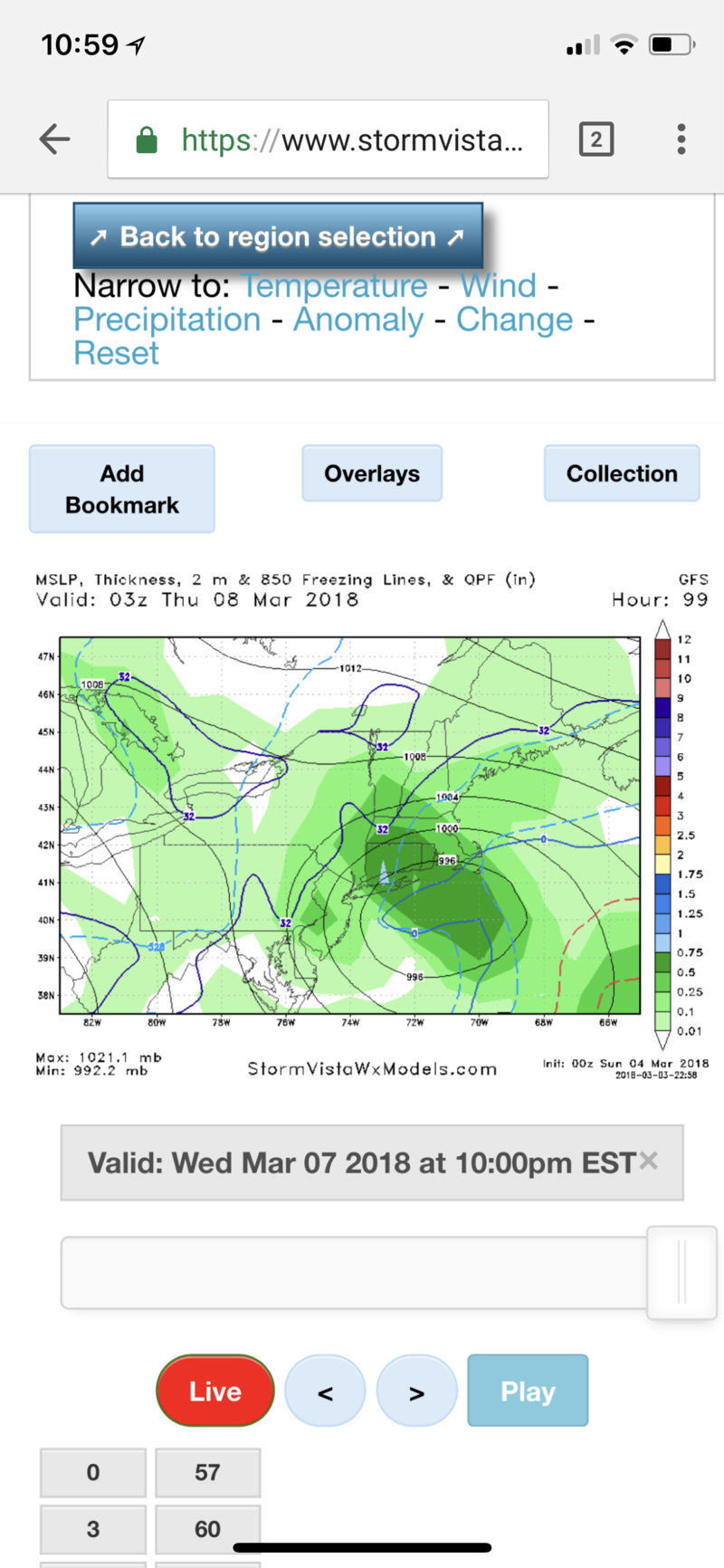
Math total snow nyc 0.8 in? thats qpf right so 8 in? That map is way diff than the wxbell, why?
jmanley32- Senior Enthusiast

- Posts : 20645
Join date : 2013-12-12
 Re: Long Range Thread 16.0
Just saw the NWS discussion. This far out it seems fairly positive. Sees a possibility of a plowable snow.
"This next shortwave/closed upper low pivots as energy to the north
in Canada dives southward along the backside of the low by mid week.
Many questions arise on exact details as this low pivots east across
the Great Lakes region tracks toward the northeast by Wednesday. How
this eventually evolves is critical, with sfc low
development/placement Wednesday and Wednesday night. Confidence
growing in coastal low development per ensemble members and
operational model solutions. However, placement of coastal low
remains in big question, with various ensemble members forecast a
coastal low, but varying between offshore of LI, or over the local
CWA.
This obviously impacts ptype, but will generally forecast snow, or a
rain/snow mix closer to the coast. Still plenty of time to iron
out any details. A plowable snow is possible."
Grselig- Senior Enthusiast

- Posts : 1410
Join date : 2013-03-04
 Re: Long Range Thread 16.0
You gotta love Bernie R. I am not going to get excited with tonight’s run or tmrw mornings run if it looks good. I will wait till Sunday nights run based on all the moving parts Bernie has mentioned, to form my opinion. By then, the storm will be 48 hrs away from starting the potential snowfall. Plain and simple

WeatherBob- Meteorologist

- Posts : 683
Reputation : 83
Join date : 2013-12-13
Location : Caldwell, NJ - NW Essex County - Altitude 500 FT
 Re: Long Range Thread 16.0
Sam champion was saying for the next storm we will see more white than wet and it's a colder storm to
frank 638- Senior Enthusiast

- Posts : 2880
Reputation : 37
Join date : 2016-01-01
Age : 41
Location : bronx ny
 Re: Long Range Thread 16.0
Craig Allen was on tv earlier and said he likes a plowable snow event for all on Wednesday.

nutleyblizzard- Senior Enthusiast

- Posts : 1963
Reputation : 41
Join date : 2014-01-30
Age : 58
Location : Nutley, new jersey
 Re: Long Range Thread 16.0
When Syos gets drawn back in here, which should be about noon tomorrow if the threat holds, that's when I'll know this threat is real.
Love what it's showing now. Let's see the same tomorrow night.
Love what it's showing now. Let's see the same tomorrow night.

CPcantmeasuresnow- Wx Statistician Guru

- Posts : 7283
Reputation : 230
Join date : 2013-01-07
Age : 103
Location : Eastern Orange County, NY
 Re: Long Range Thread 16.0
CPcantmeasuresnow wrote:When Syos gets drawn back in here, which should be about noon tomorrow if the threat holds, that's when I'll know this threat is real.
Love what it's showing now. Let's see the same tomorrow night.
Wow, CP, NWS went from rain/snow mix to rain now to all snow for the event.Mugsy, Doc and the rest of the long range crew saw all this a few weeks ago and a tip o' the hat to them!!! Looks very interesting for this upcoming storm!!!

docstox12- Wx Statistician Guru

- Posts : 8611
Reputation : 222
Join date : 2013-01-07
Age : 74
Location : Monroe NY
 Re: Long Range Thread 16.0
With regard to Mike’s comments on warm surface issues, I understand the concern. I’m one of the first on here to raise the “stickage” issue with late season storms. But there is a big difference between this storm and the one that just past. Low temperature Tuesday morning is forecast to be 27* where I am. The high in the mid-40s. Low Wednesday morning 32*. Last week the low never got below freezing, the high the day before was 60* and the temp at daybreak Friday was 41*. So the ground should be significantly colder, as well as the air temps, at the outset of the storm. Now the storm will still be fighting March sun angle and marginal temps, but there is MUCH colder air at the surface leading up to this - 15 degrees colder at least.

billg315- Advanced Forecaster - Mod

- Posts : 4558
Reputation : 185
Join date : 2015-01-24
Age : 50
Location : Flemington, NJ
 Re: Long Range Thread 16.0
Well by the looks of it, the system is not going anywhere too fast. Look at the blocking to the north and east ( courtesy of our monster still churning out there )

WeatherBob- Meteorologist

- Posts : 683
Reputation : 83
Join date : 2013-12-13
Location : Caldwell, NJ - NW Essex County - Altitude 500 FT
 Re: Long Range Thread 16.0
Looks like the NAM is digging the 500;mb farther south this run.

WeatherBob- Meteorologist

- Posts : 683
Reputation : 83
Join date : 2013-12-13
Location : Caldwell, NJ - NW Essex County - Altitude 500 FT
 Re: Long Range Thread 16.0
billg315 wrote:With regard to Mike’s comments on warm surface issues, I understand the concern. I’m one of the first on here to raise the “stickage” issue with late season storms. But there is a big difference between this storm and the one that just past. Low temperature Tuesday morning is forecast to be 27* where I am. The high in the mid-40s. Low Wednesday morning 32*. Last week the low never got below freezing, the high the day before was 60* and the temp at daybreak Friday was 41*. So the ground should be significantly colder, as well as the air temps, at the outset of the storm. Now the storm will still be fighting March sun angle and marginal temps, but there is MUCH colder air at the surface leading up to this - 15 degrees colder at least.
Regarding what you mentioned above, I think my personal favorite post-February snowstorm was March 5th, 2015. As you probably know, in the weeks prior, it was bitterly cold. Then, the day before, we had a warm front ahead of a cold front which brought temperatures in the mid 40s. But we still had a very deep snowpack and the cold front was accompanied by a very strong arctic blast with some good qpf. In the early morning hours of the 5th, the temperatures dropped dramatically so that by daybreak, it was in the upper 20s. By midday, it was in the low 20s! In addition, the snowfall rates were up to an inch per hour. So even with March daylight, the high rates and brutal cold temperatures overrode it. 7.5" in CPK, 8" in Bellerose. It was right after this event that we had the deepest snowpack of the winter. It was breathtaking!
Here is the Thread from this forum for that event: https://www.njstrongweatherforum.com/t507-march-4-5-2015-storm-final-call-obs
Here are the NWS pages:
Upton: https://www.weather.gov/okx/storm03052015
Mount Holly (you need to scroll to the year 2015, then March 5): https://www.weather.gov/phi/archives
Math23x7- Wx Statistician Guru

- Posts : 2382
Reputation : 68
Join date : 2013-01-08
 Re: Long Range Thread 16.0
My “first call map” for 3/7/18
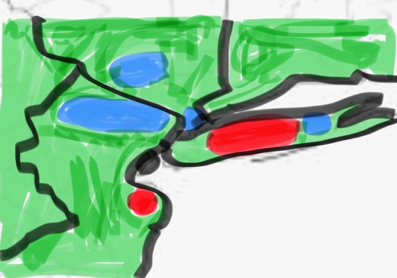
Green is 4-8” snow
Red is 8-12” locally 14”+ on LI
Blue is <1” mixed with rain

Green is 4-8” snow
Red is 8-12” locally 14”+ on LI
Blue is <1” mixed with rain
Guest- Guest
 Re: Long Range Thread 16.0
syosnow94 wrote:My “first call map” for 3/7/18
Green is 4-8” snow
Red is 8-12” locally 14”+ on LI
Blue is <1” mixed with rain
Glad to see your map skills are improving. I love the red right over my area
Scullybutcher- Pro Enthusiast

- Posts : 544
Reputation : 16
Join date : 2013-02-06
Location : North Smithtown, western Suffolk county, long island
 Re: Long Range Thread 16.0
Syos - I have to admit that I like your sense of humor. 

WeatherBob- Meteorologist

- Posts : 683
Reputation : 83
Join date : 2013-12-13
Location : Caldwell, NJ - NW Essex County - Altitude 500 FT
 Re: Long Range Thread 16.0
This should be in banter as its syo's passive agressive way of scrrewing me, scroc and a few in NJ, it can't be for real. And the crayon work, man my 4 year old does better. Yes syo I know its a joke but to new posters they may mistake it as real, was why my suggestion was actually legit.syosnow94 wrote:My “first call map” for 3/7/18
Green is 4-8” snow
Red is 8-12” locally 14”+ on LI
Blue is <1” mixed with rain

jmanley32- Senior Enthusiast

- Posts : 20645
Reputation : 108
Join date : 2013-12-12
Age : 43
Location : Yonkers, NY
 Re: Long Range Thread 16.0
wasn’t trying to screw anyone. It’s just my call. This storm will have its warm tounges too so I’m guessing where they will bejmanley32 wrote:This should be in banter as its syo's passive agressive way of scrrewing me, scroc and a few in NJ, it can't be for real. And the crayon work, man my 4 year old does better. Yes syo I know its a joke but to new posters they may mistake it as real, was why my suggestion was actually legit.syosnow94 wrote:My “first call map” for 3/7/18
Green is 4-8” snow
Red is 8-12” locally 14”+ on LI
Blue is <1” mixed with rain
Guest- Guest
 Re: Long Range Thread 16.0
damn you Syo Damn you. 
 You are probably right. I will be in the screw zone
Grselig- Senior Enthusiast

- Posts : 1410
Reputation : 140
Join date : 2013-03-04
Age : 54
Location : Wayne NJ
 Re: Long Range Thread 16.0
Okayyyy....I do not see your basis on this at all as models are showing pretty solid snows everywhere (as of now, knock on wood), but heck you were right more so than others last time so, let it fly and good luck! But I am those in blue I am pretty sure agree that we hope your dead wrong.syosnow94 wrote:wasn’t trying to screw anyone. It’s just my call. This storm will have its warm tounges too so I’m guessing where they will bejmanley32 wrote:This should be in banter as its syo's passive agressive way of scrrewing me, scroc and a few in NJ, it can't be for real. And the crayon work, man my 4 year old does better. Yes syo I know its a joke but to new posters they may mistake it as real, was why my suggestion was actually legit.syosnow94 wrote:My “first call map” for 3/7/18
Green is 4-8” snow
Red is 8-12” locally 14”+ on LI
Blue is <1” mixed with rain

jmanley32- Senior Enthusiast

- Posts : 20645
Reputation : 108
Join date : 2013-12-12
Age : 43
Location : Yonkers, NY

aiannone- Senior Enthusiast - Mod

- Posts : 4827
Reputation : 92
Join date : 2013-01-07
Location : Saint James, LI (Northwest Suffolk Co.)
 Re: Long Range Thread 16.0
jmanley32 wrote:Okayyyy....I do not see your basis on this at all as models are showing pretty solid snows everywhere (as of now, knock on wood), but heck you were right more so than others last time so, let it fly and good luck! But I am those in blue I am pretty sure agree that we hope your dead wrong.syosnow94 wrote:wasn’t trying to screw anyone. It’s just my call. This storm will have its warm tounges too so I’m guessing where they will bejmanley32 wrote:This should be in banter as its syo's passive agressive way of scrrewing me, scroc and a few in NJ, it can't be for real. And the crayon work, man my 4 year old does better. Yes syo I know its a joke but to new posters they may mistake it as real, was why my suggestion was actually legit.syosnow94 wrote:My “first call map” for 3/7/18
Green is 4-8” snow
Red is 8-12” locally 14”+ on LI
Blue is <1” mixed with rain
Based upon my gut and more importantly, this year's experience, I would increase the red to 18-14, increase the green to 12 plus and downgrade the blue to just fog. Just cold damp black ice fog.

Grselig- Senior Enthusiast

- Posts : 1410
Reputation : 140
Join date : 2013-03-04
Age : 54
Location : Wayne NJ
 Re: Long Range Thread 16.0
gfs not good look forcoast or about 25 miles inland everywhere and even fyrther for 6+

jmanley32- Senior Enthusiast

- Posts : 20645
Reputation : 108
Join date : 2013-12-12
Age : 43
Location : Yonkers, NY
 Re: Long Range Thread 16.0
Can this storm bomb out like last or whole diffent setup?
Carter bk- Posts : 73
Reputation : 5
Join date : 2017-12-07
 Re: Long Range Thread 16.0
LMAO, 18-14 and ice fog.Grselig wrote:jmanley32 wrote:Okayyyy....I do not see your basis on this at all as models are showing pretty solid snows everywhere (as of now, knock on wood), but heck you were right more so than others last time so, let it fly and good luck! But I am those in blue I am pretty sure agree that we hope your dead wrong.syosnow94 wrote:wasn’t trying to screw anyone. It’s just my call. This storm will have its warm tounges too so I’m guessing where they will bejmanley32 wrote:This should be in banter as its syo's passive agressive way of scrrewing me, scroc and a few in NJ, it can't be for real. And the crayon work, man my 4 year old does better. Yes syo I know its a joke but to new posters they may mistake it as real, was why my suggestion was actually legit.syosnow94 wrote:My “first call map” for 3/7/18
Green is 4-8” snow
Red is 8-12” locally 14”+ on LI
Blue is <1” mixed with rain
Based upon my gut and more importantly, this year's experience, I would increase the red to 18-14, increase the green to 12 plus and downgrade the blue to just fog. Just cold damp black ice fog.

jmanley32- Senior Enthusiast

- Posts : 20645
Reputation : 108
Join date : 2013-12-12
Age : 43
Location : Yonkers, NY
 Re: Long Range Thread 16.0
Not go be a crazy huge storm like this past one, its small and only gets to about 990mb, this run of GFS 987 but as its moving NE.Carter bk wrote:Can this storm bomb out like last or whole diffent setup?

jmanley32- Senior Enthusiast

- Posts : 20645
Reputation : 108
Join date : 2013-12-12
Age : 43
Location : Yonkers, NY
 Re: Long Range Thread 16.0
We will see how later runs look, I am waiting for Sunday nights run on all models, again this is a close call on low level temps.

WeatherBob- Meteorologist

- Posts : 683
Reputation : 83
Join date : 2013-12-13
Location : Caldwell, NJ - NW Essex County - Altitude 500 FT
 Re: Long Range Thread 16.0
Serve me some cmc please!! Euro was too far east hammers you know where. Not concerned 4 days out. But 00z cmc was the best run 12 plus smack over NYC and surrounding areas.

jmanley32- Senior Enthusiast

- Posts : 20645
Reputation : 108
Join date : 2013-12-12
Age : 43
Location : Yonkers, NY
 Re: Long Range Thread 16.0
Can you post maps pleasejmanley32 wrote:Serve me some cmc please!! Euro was too far east hammers you know where. Not concerned 4 days out. But 00z cmc was the best run 12 plus smack over NYC and surrounding areas.

weatherwatchermom- Senior Enthusiast

- Posts : 3893
Reputation : 78
Join date : 2014-11-25
Location : Hazlet Township, NJ
Page 15 of 34 •  1 ... 9 ... 14, 15, 16 ... 24 ... 34
Page 15 of 34
Permissions in this forum:
You cannot reply to topics in this forum
 Home
Home